Gujarati Newspaper puts up this article on 2nd August..those interested can read it here...and was put up headlines here..
City Wise city performance till July 31st 2012 with diagrams..Current weather Page.
Taking into consideration all the parameters and possibilities, and without going into the details of each place mentioned, i would summerise and estimate the amount of rainfall for August in selected Cities as follows:
Estimate for August Only:
Mumbai : 320-370 mms (Avg of Scruz and Colaba). Normal 496 mms.
Pune: 210 mms (Please note the 87 mms measured on 1st July is taken in August quota as per norms). Normal: 125 mms.
Thane: 470-500 mms. Normal: 637 mms
Ahmadnagar: 50-60 mms. Normal: 98 mms
Surat: 180-200 mms. Normal 260 mms.
New Delhi: 150-170 mms. Normal 258 mms
Bangalore: 100-120 mms. Normal 142 mms
Chennai: 80-100 mms. Normal 140 mms.
As I have mentioned, the All India rains will be around 20-22% deficient for the Month, and the Over All Seasonal deficit end August may be around -18% to-21%.
Special Monsoon Watch for August:-
Deviating from the routine, This additional MW has become necessary due to the SW Monsoon's poor performance in June and July 2012.
Seasonal Rainfall from 1st June - 31st July 2012;
Indian Regions:
NE -10% NW -36% Central -15% South Peninsula -23%.
 India: -19%.
 Analysis of India as a whole shows: 89% of India is in the deficient range (deficient range is -1% and below. Not -20% as taken by IMD.).
11% is in the normal range. (Normal means actually in the positve range).
The best performance yet is Sikkim and adjoining W.Bengal at +16%.
Most deficient is Saurashtra and Kutch at -79% followed by Punjab at -67%.
What has gone wrong this year?
The reasons for deficient rainfall could be attributed to the late arrival and subsequent weak monsoon conditions over the country, the axis of monsoon trough remaining shifted to the north of its normal position, and non-occurrence of low pressure areas (or land lows) across the country.
Also, uneven spatial and temporal variability within the season may result in deficits in the seasonal mean all-India rainfall (AIR) which can have profound social and economical consequences.
What actually plays an important part for a good Monsoon?
The years 1965 and 1972 were years of severe drought over India and its surrounding area. The dynamical and thermal features of these seasons are contrasted with those of the normal monsoon. The main local abnormality during drought years is the shift of the monsoon trough northwards and the development of anticyclones over central India in the lower troposphere.
Drought years are associated with lower chances of low pressure areas to intensity into depressions, less westward movement, more horizontal extent, intense pressure departure from normal in comparison with flood years. However, more monsoon disturbances tilt significantly during flood years. The rainfall associated with these disturbances is highly variable and does not depend on the intensity, horizontal and vertical extent of the individual system. More number of lows intensify into depressions during strong monsoon conditions compared to those of weak monsoon conditions. Lows and depressions during strong monsoons have more westward movement and longer life period. Generally, very few lows form during break monsoon and none of them intensify into depression.
Hence, the presence of mid-tropospheric heating during strong and weak monsoons is essential for the formation of depression.
Parameters that will influence the August Rainfall:
The main and holding parameter is the location of the Monsoon Axis (Trough). Depending on the alighnment of this axis, the following vary and fluctuate:
1. Systems form The Bay:-
It is the depressions and cyclonic circulations/storms that play an important role in the distribution of rainfall over the Sub-Continent.
This year, we have had BB1 and BB2 and in reality BB1 was as good as a non starter.
It is, therefore, of interest to know to what extent the absence of these synoptic systems causes deficient rainfall during the individual monsoon months. This aspect has been examined by computing the average rainfall of the different meteorological subdivisions of the Indian plains north of 15 degrees N lat. for monsoon months that were free from depressions and cyclonic storms.
During the period 1891-1980, there have been 25, 13, 7, and 4 occasions of June, July, Aug., and Sept., respectively, when no depressions or cyclonic storms moved through the Indian land area.
A study also shows that the absence of monsoon depressions and cyclonic storms is not the main factor that causes deficient rainfall and consequent drought conditions in India.
Another study had shown that the occurrence of moderate to heavy rainfall mainly depends upon their frequency, life span, track followed and origin of these disturbances provided there are no inhibiting meteorological factors like `break' monsoon situations.
Initially, no system from the Bay is expected in the first week/10 days of August. A system BB3, is possible later. (See below)
Indicator for this August: Overall Favourable.
2. MJO:-
The MJO wave shows weakness initially till the 12th at least, as it travels Eastwards. Currently it is still "within the weak circle".
While moving eastwards, it can trigger more typhoons in the West Pacific Ocean, and send a couple of more "pulses" into the Bay..around 12th/13th?
After the 15th of August, forecasts say the MJO picks up again in the Indian Seas.
Indicator for this August: Favourable for 2/3 systems from the Bay in the second half.
3. ENSO:-
The ENSO conditions are likely to run through the Neutral conditions throughout August. As El-Nino is just on the "threshold" it is not expected to establish itself in August.
For most of month of July, the El Niño-Southern Oscillation (ENSO) demonstrated neutral values. The end of July, saw Niño3.4 at just threshold value. Nino 3 is the only sector above El_Nino threshold.
Suspicion that the episode now developing in the Central Pacific may not be a normal El Niño and instead could be its variant El Niño Modokai (pseudo-El Niño). However, the latter can be confirmed as an episode only in September.
During an El Niño Modokai episode, seasonally, it is the North-West region of India that usually bear the brunt of drought, followed distantly by peninsular or South India. Interestingly, this is how exactly the deficiency pattern is panning out this monsoon season.
Tropical cyclones formed during the year prior to the El-Nino years [El-Nino (-1) year] are seen crossing mostly (in 79% of cases) either north of 17 degrees N or recurving in northeastward direction. In other years this kind of behavior is not generally observed.
Indicator for August: Getting Un favourable by the 3rd week of August.
4. SOI
The SOI is showing the latest as +0.9.
Indicator for August: Favourable for just about Normal rains.
4. SST:-
A preliminary study of synoptic sea surface temperature (SST) measurements made by ships plying over the north Indian Ocean has revealed the existence of an interesting ocean-atmosphere interaction. Large-scale monsoon failures over India during 1965 and 1966 caused an increase in SST in the Arabian Sea and Bay of Bengal. The warm seas may have been the cause of a persistent anticyclone that formed in the upper troposphere over the Indian seas immediately after the 1966 monsoon and persisted there until the monsoon of 1967, which was a normal monsoon.
This is one parameter linked to the IOD and the IOD is predicted to be neutral..or mildly positive at +0.18...SST in the Arabian Seas are high presently, and high in the West/SW of the Bay...
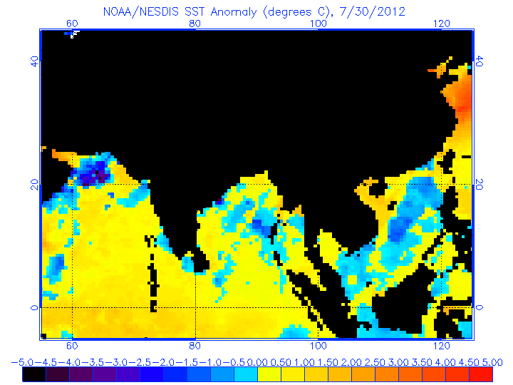
Intensity of upwelling over the coastal waters of Somalia and Arabia (which is apparently regulated by the strength of the monsoon) is a factor with a major role in this interaction. These large-scale changes are found to affect the cyclone tracks also. This mechanism could, therefore, be the cause of the 3-yr oscillation in subtropical westerlies /tropical easterlies over south Asia, Indian monsoon rainfall, and tracks of the post monsoon severe cyclones of the Bay of Bengal observed during the decade 1965-1974 and reported by Joseph (1975, 1976).
Indicator for August: Again, just favourable for the Monsoon to "survive" not really "revive"
5. Jet Streams:-
During 1972, a year of large-scale drought in the Indian summer monsoon rainfall, the mean u-field at 150 mb shows a weaker than normal tropical easterly jet stream over south Asia and a stronger than normal subtropical westerly jet stream over Australia; the mean v-field shows that the cross-equatorial northerlies are weaker and displaced eastward by similar to 20 degrees long.
The two years (1970 and 1975) of highest monsoon rainfall for India of the decade 1970-1979 were compared with the two years (1972 and 1979) of lowest monsoon rainfall in the strength of the subtropical jet stream (STJ) over Australia as seen from an analysis of monthly mean u-fields of July and Aug. It is seen that, during the poor rainfall years, the STJ is similar to 20% stronger than in the good monsoon years.

It will be interesting if we find any similar occurrences this year. As yet the Jet Streams over Australia are much stronger. Easterly Jet Streams in the upper Himalayan regions are also very strong. Could possibly lead to rains in Northern Pakistan, possibly if they slide down a bit.
Indicator for August: Negative for good flow.
Forecast for August:
If we see and study all the factors, it’s quite puzzling and not leaning towards any one side..its something like "yes and No'. But that does not answer our question.
To summarise:
The negative indicators may just about disrupt an ongoing monsoon process, but the the positive parameters, which may ensue later, may be able to at least keep up with the normal tempo.
Initially, the Axis mves North, and possibly brings about a "break Monsoon" condition in the 1st week. Excessive rains in the Hill states and Upper UP. But east and west off shore trough becomes weak.
A couple of systems are possible from the Bay after the 12th, due to the MJO moving eastwards into the S.China Sea.
An eastward propagation may lead the MJO into a weak phase during the first half of the month. The MJO phase, seeing its periodical wave, stands a chance of strenghtening after 15th August.
By end Augaust, El-Nino could rear its head, but meekly.
Consequently, NW India, Interior Southern Peninsula and Gujarat would get deficit rains in the Month of August.
Central India and NE would be normal, while West coast, Karnataka and Konkan could end up with slightly deficit rains during the month.
Over all, on the ALL India Level, August can just about get the normal August quota. This means, the carry forward deficiency could end up around -17% to-21% level..
Pakistan: North Punjab can get normal/ slightly excess rains in the first half of August. We see no meaningfull increase in the Central (South Punjab and Sindh) regions till then.
If, as mentioned above, the couple of systems from the bay develop enough energy to generate rains along its track upto Pakistan (thru India), there is hope of a fairly reasonable revival of the monsoon in sindh and the southern coastal regions.
First half of the month will see very good precipitations in Nepal. Subsequently, normal rainfall will prevail. Nepal is already in excess, and August will further boost the surplus.
Compiled by Rajesh Kapadia with very useful contributions from Rajan Alexander.
Curiosity Landing on Mars..A Huge Event !..4 days from Mars !..See Space News Page.


37 comments:
Awesome Sir,
Such a lengthy note...on freelance...
Shows your passion and your service.
AGREED WITH MR PRADIP, sir i want to knw it addition to meterology wat are ur hobbies and job profile because evn after 4 decades of dedication sometimes its difficult to get perfection in ths field but u succeded,
જય શ્રી કૃષ્ણ
@ Rajesh Sir. Superb analysis. Got to know many technical factors which are responsible for Monsoon behaviour. Hats off Sir for your work.
Yes Rajesh. Looks awesome. Congrats.
One correction: deficient range is -19% (not 1%) and below
A good idea would be to update the forecast if necessary after receiving comments - make it sort of a people's forecast as opposed to the IMD or pvt agency.
I am sure readers will have many tit bits of information; data and information.
I am sure they will react after digesting the "lengthy note" and contents.
Thanks Pradeep, abhijit, Pavan and Rajan:
Rajan, thats not a correction. I know IMD considers even -19% as "normal". But, i have put -1% and below as deficit. Its much more practical.
Sure, i have requested all, and i really want each and every reader to put in his views.
Thanks for the report Rajesh sir and Rajan..
One thing that I am unable to understand is the following statement..
"During the period 1891-1980, there have been 25, 13, 7, and 4 occasions of June, July, Aug., and Sept., respectively, when no depressions or cyclonic storms moved through the Indian land area"
Did you intend to add something to this point because I see no follow up in the report to the above para, or have I missed it? Can you explain..
Sir, regarding 3yr oscilatn of westerlies and easterlies, whether this situation wil continue for next year, whether there may be a stronger low or depression aftr swm? As it happend in 2001 ,02 and 03
After heavy rains for 3 days, yesterday intensity of rain reduced considerably. Just few spells with sun out over Badlapur noted. So past 24hrs recorded 12mm rain here.(i.e yesterday 8.30am to today 8.30am.)
GSB: In short, it explains that lack of depressions or systems are not the only factor which may bring in a drought year. Deficit rains may be due to other parameters also. Last 2 years we had a surplus monsoon, but hardly any lows from the bay.
Readers from Mumbai: Check Mumbai Page for current weather for next 2 days. Will not publish "over" this article for 2 days.
Other readers also may please see Current weather page for 2 days..Thanks.
Rajesh,
Wow! So much valuable data. Thanks a lot for sharing them.
Rajesh Bhai,
In a normal year for Bay systems entering from east, they get to feed off only water logged land areas to sustain intensity upto Gujarat. This year as initial intensity did not mark up to create much amount of water on land, probably whatever systems arrived did not sustain. Do I have a factor in the assessment ?
Awesome job done Rajesh. You have also given hope of post Monsoon cyclone year
Thankyou Rajesh sir for posting such a knowledgeable content.One thing I like the most in this site is the lenghthy blog and simple language. By reading your blog I have gained much knowledge about meterology.
"During the period 1891-1980, there have been 25, 13, 7, and 4 occasions of June, July, Aug., and Sept., respectively, when no depressions or cyclonic storms moved through the Indian land area"
This means that the probability of having Depressions / Storms increases in August with the best probaility in September.
Good analysis Rajeshbhai
Thanks Rajesh for such detailed analysis with such a good analysis.
Here Badlapur was having cloudy & windy conditions with light showers. So Max temp was 29.5d C today here. And at 4.30pm medium to heavy rain spell of 40mins reduce temp to 26d C now. So 11mm rain measured here from 8.30am to 5.30pm period today. So pleasent weather conditions here.
Dear Rajesh,
Congrads. It is a painstaking analysis. You have come out with appropriate reasons. Hats off.
(1) The traditional monsoon trough line off shore of Kerala, Karnataka coast is missing.
(2) Instead at many occasions RIDGE was noticed along the said coast.
(3) The power house of SWM namely the Mascarene High is NOT located to its normal position; but seen oscillating east-west.
(4) Even though not monsoon troughs/lows formed in the Bay, invariably CB clouds with considerable vertical extend formed in the Bay & inland closed to coast.
(5) I do not know how IMD is categorizing [a]Deficient [b] scanty or [c] normal rainfall.
But in all catchment area of major rivers in India whether it is EAST flowing or WEST flowing, the amount of rainfall is drastically low than normal.
{But hope that it will improve in Aug & Sep}
Sir, why stil the maxm temp are above 40deg in places like sriganganagar (41.4), madurai (40.4) and the minm temp of int kar and some places in maratwada is below 20deg
Yesterday an overcast day & windy conditions with in between spells noted in Badlapur. So past 24hrs recorded 16mm rain here.(i.e yesterday 8.30am to today 8.30am.)
After a break of 4 days...Agumbe records 8 cms yesterday. Bhagamandala and other regions of coorg continues to disappoint. KRS level would not improve until coorg gets consistent heavy rain.
Temperature in TN very high. Chennai at 37.3 , Pondi at 38.8 and Madurai at 40.3. For this time of the year its a bit surprising. Bangalore at 28.7. But its very dry.
Thanks Rajesh Sir for detailed analysis.
This year the Bay of Bengal (BB) branch was quiet normal. The let down was from Arabian Sea (AS) branch. We had BB's but no AS, Hence no rain in Kutch, Saurashtra, Punjab and Pakistan.
When BB enters Indian sub-continent it requires support from AS to sustain and that was missing this year. Even today I see Arabian Sea without any meaningful clouds or depression.
If these conditions does not change for a month or two then there are very high chances of a cyclone forming over Arabian sea and hitting Gujrat and Pakistan coast.
Very good analysis Rajesh. Even IMD just now have announced that Rainfall btw August to October will be deficient. But IMD havent given detailed analysis like you, they just considering El Nino factor. Btw its looking like Mumbai and north konkan will get heavy rains from saturday to monday. Sunday rain could be really heavy. Any particular reason for strengthening of off shore through off north konkan?
svt- A low is forming over Bay at 20N-87E today, due to this there is a possibility of increase in rainfall over North Konkan on Sunday
Here in Badlapur just now localized cloudburst type torrential rain noted . 20mm rain in just 20mins torrential spell. And frequent spells from morning too there. So today from 8.30am to 3.30pm, 32mm rain measured here( in that 20mm in just 20mins. )
Rajesh sir,
This is an excellent analysis. Ideal for those us trying to learn more about the subject.
Thank you
Vivek
Raining in South Bangalore for the last 15 minutes. Its light rain.
@Bhavik, Yeah bay low have formed off Orissa coast. But so far this season bay low havent attracted good moisture from Arabian sea off Mumbai coast. Hopefully this time vortex forms.
Rajesh sir made similar microscopic analysis during start of monsoon and now it is after 2 months. I need to still figure out the difference.
Mahableshwar is getting excellent torrential downpours - due to which North Karnataka can benefit.
Entire south peninsula completely dry. Probably this is first time when for largest number of days with no rain.
http://timesofindia.indiatimes.com/india/India-confirms-drought-as-El-Nino-looms/articleshow/15335714.cms
Viravanalluran: Thanks, and your observations are abs correct..of course the ridge is visible off the west coast, but actual ridge effect is minimum, like NW winds.
and for the same reason, as yours, i put -1% as deficient for my analysis.
Today humidity was at much higher level. From the last few days I have not seen even a single drop of rain. In short if I want to conclude I will like to conclude with this statement " There is absolutely no difference between the weather which normally prevails during the may month and the weather which is prevailing today. Rajesh sir I am eagerly waiting for some good news. This year I have seen only some drizzles and light rain and not heavy rain. When the heavy rain will occur in Surat????
To all readers: Report as on 1500 UTC does not show any prominent development of a low in the Bay of Bengal..BB3 IS NOT yet formed...there is an extension of the monsoon axis, and at 996 mb, stretches right along the axis till Bihar.
Will update Saturday morning..
Friday was the ELEVENTH above average All India rainfall for the season.
Till date we have had 11 (17%) above average days and 53 (83%) below average days.
why is it so windy in mumbai?Any reasons??
Badlapur measured 40mm rain in past 24hrs.(i.e from yesterday 8.30am till today 8.30am )
Rajesh Sir,
Some mild rains occurred in Chennai areas ending 8.30 am today and the temperature was 3 to 4C below normal.
in mm
Poondi - 5
Tamaraipakkam - 5
Korattur Anicut - 5
Chennnai City (Nungambakkam) - 3
Avadi - 3
Poonamalle - 2
Chennnai AP (Meenambakkam) - 2
Redhills -2
Guindy -2
Cholavaram - 2
Chembarbakkam - 2
Tiruvallur - 2
wow spot on rajesh sir...heavy rain since 10:30am...
Thanks a lot.
Post a Comment