Thursday, February 28, 2013


Yes ! The Konkan Strip heating has started ! And all along the "dark yellow" belt put up by Vagaries.
Hottest (also in India) on Friday was Ratnagiri at 38.5c, followed by Panjim at 37.2c. Tiruchirapalli at 37.0c, Mumbai SCruz closely behind at 36.8c ( at +4.7c, seems to be in a hurry to achieve what i thought would take till Sunday).
However, not all Konkan is heating up. Alibag was 31.2c and Dahanu was 31.0c. 
New Delhi Sjung was a comfortable 25.1c, while Pune was 33.7c. Kolkata rose till 33.6c Friday....
Highest in Asia was in Thailand, Lamphun at 39c..


March Outlook on Current Weather Page....

The last day of the month of February saw light rain/snow restricted to Kashmir and HP hills.

But, from the 1st of March, In the absence of any active systems, the weather is expected to be dry all over the India, Pakistan and Nepal from 28th February for the next 5 days, till 4th March.
Light rains in Kashmir and HP hills on 5th March.

Warming up from first Day of March:
No system dominates, so, the Upper Northern palins of the regions will have strong to gusty NW winds.
This will encourage the day temperatures to rise gradually. 


Delhi NCR: Clear skies.  
From the 1st of March, thereafter, a gradual rise to reach 29c by the 4th of March. Nights will be remaining pleasant around 12/13c till 4th.

First 4 days of March are forecasted to warm up in Central India due to Easterly winds. similar east winds will warm up the Gujarat and Konkan coast. 

Mumbai SCruz: Mumbai Colaba was a pleasant 30.2c today (Thursday), and Scruz was 33.8c..However, 
1st March to 4th March will see Easterly winds causing the days to rise regularly to reach 36c by 2nd/3rd March (Scruz). Low temperature will be around 20c.
Outer townships may touch 38c by the 2nd or 3rd of March.

Pune: Warm days with the days touching 37c by the 2nd or 3rd of March. Nights will also hover around 17/18c.

Region in the North Konkan, Madhya Maharashtra or Gujarat may soon see the first 40c of this year.
Vidarbha sees a rise to 37/38c in the first week. Goa should see a rise to 36/37c by Sunday.


Surat: Thursday Surat reached 34.2c. Warming gradually to reach 37/38c by the 2nd or 3rd of March. Bharuch also likely to warm up and reach 37/38 by the 2nd of March.

Kolkata: Seeing Thursday's high of 31.4c, we notice around 31c since last 3 days. I estimate the first 4 days of March will be maintained around 32/33c.

In Pakistan, Karachi will remain warm around 31/32c till 4th March, but we see Hyderabad (Sindh) heating up to 36c by Sunday.


Vagaries' views on March Weather for the Sub Continent later tonite

Monday, February 25, 2013

NEW SUMMER COMPETITION OPEN FOR ENTRIES>>SEE MARCH COMPETITION PAGE FOR RULES:

Highest in India on 26th,Tuesday was at Kurnool, 37.2c.
Maharashtra's highs: Satara 36.9c, Pune Lohgaon 35.5c, Colaba 29.9c vagaries 31.4c, and lowest was 12.2c at Nasik.
Vidharbha nights are cooler than normal as Yeotmal was 14.8c (-3.9c) and Amraoti at 14.8c (-3.4c).


An exuberant Birding trip to Thol, Gujarat, has been a very good experaince with a few lifers (seeing the bird for the first time)..an exotic water body with numerous water birds and the only place in India, where, in one location we get the big five, Storks, Cranes, Pelicans, Flamingoes and Geese. 
Album link put up in the "links" on the right of this page.

Weather:

From Wednesday 27th, rising trend in day temperatures will be observed in Northern plains, Central, Eastern and Southern parts of the country. Central and Western India, see a marked rise from Thursday and Friday.
The first 40c of this season is likely in the country around after Friday on this weekend.
A vagaries map will be put up on Wednesday evening...

Major heating is not seen in Pakistan though.
Across the border, Islamabad remains pleasant due to rains, and Karachi will be around 30/31c next few days. Even Sindh regions remain reasonably within the normal range.Hyderabad remains in the 29c-14c range.

Mumbai Scruz: Tuesday/Wed/Thursday: Clear and warm. These 3 days days will be around 33/34c and nights will remain around 17c. Expecting a very warm begining to the first day of March for Mumbai and outer towns. (Maybe 38/39 in outer towns)
Outer townships will be warm and around 34/35c rising to 36c on Thursday.

Pune: Warm and sunny. Days around 34/35c and nights around 14/15c.

Delhi NCR: Light rains possible in some parts on Late Tuesday night or early Wednesday morning. Days around the 25/26c- 12c range.

Kolkata: Day temperatures will rise from today's 31c to 32/33con Tuesday/Wed and further 34c on Thursday 28th.

Surat: Warm and sunny, with the highs around 33/34c. 

Chennai too will see days getting warmer from Thursday 28th.

F-4 moves into Northern Pakistan on Tuesday, 26th. 
From Tuesday evening, rainfall increases in the Punjab region of Pakistan and good rainfall for Islamabad from Tuesday night into Wednesday daytime.

Precipitation in Kashmir and HP.Tuesday night sees light rain in Punjab and adjoining Haryana. Amritsar may see light rains on Tuesday night and Wednesday.

On Wednesday, rainfall continues in the above plains. Delhi NCR can become cloudy from Tuesday evening and get light rains early Wednesday morning.
Good rains for Ludhiana and Chandigarh regions.

An extreme High pressure region, of 1040 mb, will form over the Ladakh region, and can "break up "the WD.


Friday, February 22, 2013

Do not miss Video at the end of this article

The 06UTC chart from PMD NMCC, shows F-3 getting "organised" and active over Pakistan. The trough, (WD) with the main primary Low is over Pakistan Sindh region, with the Northerly trough in the NE forming clouds over the North Indian regions. 


And Yes. Islamabad and surroundings had good rainfall last 9Thursday) night as mentioned, with 28 mms measured overnight. In the region, Mianwali was higher with 46 mms. Murree (35 kms away from the capital) received an inch of snow.

As expected, system will move into India tonite. Precipitation and cloudiness will increase as the moisture incursion towards the trough moves Eastwards. 
Saturday/Sunday map (below)on vagaries should tally (for rain and clouds).
The Low over Maharshtra is seen in the region also.
The Southern low over Kerala is short lived and may bring light showers in the Lakshdweep Islands region.
So, it seems, events may move as per yesterday's (below)estimate, and no changes in the forecast may be needed.

F-4 is also seen in the West, and the isobars are getting organised, almost to 2 mb difference between them..indicating the low getting strengthened. But, that is still vague, though entering into the Northern regions of the sub continent by the 26th seems certain.

There will be no blog published till Monday. I am away on a Nature and birding trip to Thol Bird Sanctuary, Mehsana, Gujarat next 3 days. 
FB inter actio will also be very much restricted. Vagarians requested to continue their inter action and keep other readers informed thru comments on blog.


In the meantime, I must share this amazing and absolutely superb video taken from the International Space Station. Another Incredible Timelapse from the ISS.
Covers so many aspects of our Earth's weather, and portraits a Space view of a silvery Moon setting into the Earth’s atmosphere, the dazzling Milky Way rising into a brilliant sunrise, airglow of all colors, popping lightning , shimmering aurorae, and incredible views of the stunning space station and our gorgeous planet.
Request all meteorologists and those who love Nature to watch this till the end....mark the lightning starting at 0.45 secs, Milky Way at 1.45, (i am sure you will not be able to leave it half way thru)


Thursday, February 21, 2013


F-3 expectedly  moving in with gathering force:

F-3 currently (Thursday Evening) at 65E and around 35N, has now an induced Low at 28N and 60E, around Central Sindh region...An elongated trough extends SE wards into Western Rajasthan...

F-4 is seen as a 1012 low over 55E and 35N...close isobars in the East of the system and an extended trough sloping SE indicates its Eastward movement.....Arriving around Tuesday 26th...

The other Low in S.Maharashtra is now at 1010 mb and may persist or move NE...

Heavy rains for Islamabad tonite.(Thursday Night)

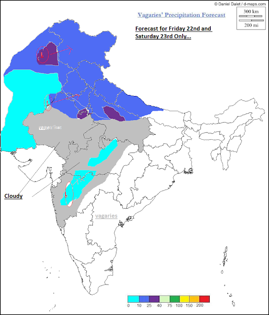
Next Few Days : (Map above refers to Friday and Saturday Only)

Friday 22nd: F-3 into Northern Pakistan and Pak Punjab. Rains over Sindh (including Southern regions), and light rains around Karachi. 
Rain/snow over Kashmir, HP, Punjab and Northern Haryana. Cloudy over Northern Rajasthan and partly cloudy for Delhi. A Shower late night in some parts of NCR.

Low in the Mah region brings some evening rain and thunder in S.Madhya Maharashtra in Pune and Solapur Districts. Thundery developments around Pune on Friday night with rain in the vicinity.
Light rains to Northern Mah (Nasik and Akola) and adjoining Southern most MP (Nimar and Betul regions) and cloudy weather in Marathwada and West Vidarbha.

Saturday 23rd: Rainfall moves into Delhi NCR. Rainfall be be heavier in South of Delhi, the Delhi-Jaipur belt getting some heavy showers. 
Delhi City avg rainfall: 15 mms (till Sunday morning), and Saturday /Sunday days will fall to a maximum of 21/22c.
Lucknow and the UP region West of Lucknow get showers, and Utteranchal gets rain/snow.
Mah.Low dissolves.

Sunday 24th:  F-3 moves away to the East, and covers Nepal, but the strength has reduced. Kathmandu gets some rains on Sunday, keeping the temperatures low.
Faster movement occurs under the influence of mid- or upper tropospheric trough. 
For Delhi NCR, Day gradually getting brighter, Clear Sunday night for Delhi. Monday morning low around 10c.

Monday 25th: A rainless day for the sub-continent.

Southern staes of Karnataka and TN remain dry all days.

Kolkata clear, and weekend warming up to 31c with nights around 18/19c.

Mumbai: Partly cloudy on 23rd Saturday/ 24thSunday. Not really cooling down much now. Saturday and Sunday will be in the 32-19c range. 
Mumbai's Outer townships will get partly cloudy with cumulus heads popping up on 22nd Friday. 23rd Saturday and 24th Sunday will be almost clear and warm, with days around 34/35c and nights around 18c. E/SEwinds on Monday will show further rise in day temperatures.

Pune weekend getting hot, with the maximum attempting to touch 36c.


Tuesday, February 19, 2013

19th and 20th..the 2 dry days forecasted shown in the rain accumulation image below..Now, as per estimate...F-3 moves into India on Thursday 21st...


and F-3 has now moved and taken over......


Seems the Low** (the low referred see below in yesterday's article) in the Arabian Sea off the Kerala/Karnataka coast  has also moved NE inland. Estimated to move N/NE from 20th..(it is a day earlier than what was said in yesterday's article)...
Forecast same as given below...F-3 over Pakistan on 21st, 22nd over India and 23rd precipitation for Delhi NCR..city forecast as below...

Southern TN , mainly the Coimbatore District, got torrential rains on Monday night. Periyanaickenpalayam got 110 mms, Annur 80 mms.
A 24 hr record breaking 98.5 mms was measured in Coimbatore AP, its highest for a 24 hr period in February, beating the previous record of 61.4 mms of 25th Feb 2000. 

---------------------------------------------------------------------------------------------------------

Published on Monday Night 12 mid Night:
Weather Now :
Now, with another WD on its way, this month too seems wet and cold. 
The next in line ,F-3, would reach and precipitate over Northern Pakistan and Central Sindh on 21st of Feb On 21st, Karachi will be cloudy, and rains expected in Southern Sindh region. 
19th and 20th would be almost dry for India, 21st, precipitation over the Kashmir and West Raj would resume , though light.

By 22nd, F-3 would be over India, initially covering Kashmir, HP, Punjab and Haryana. A East -West trough along the 20N line, could create some convection in the Vidharbha region on 22nd. 
**A low could possibly form on the North Karnataka/Goa coast on the 20th. This would move a bit inland, and get embedded in the trough.

By 23rd, precipitation would be covering Delhi NCR.

Mumbai starts heating up from Tuesday 19th, peaking on Thursday at 35c. 
Friday 22nd will be cloudy and a few degrees lower. Cloudy weather for Pune/Nasik and Aurangabad on Friday 22nd. 

Outer townships of Mumbai will be gettng warmer, and may reach 35c or 36c by Thursday, as SE winds take over. Partly cloudy towards the hills will ease the temps on Friday...nights will also rise gradually from Tuesday morning...finally touching 18c...by Friday

Surat, dry and heating up to 36c next few days. cooling a bit from Friday.

Next few days till Friday, Kolkata remains in the 26-15c range, with light clouds till Wednesday.
Dry for Kathmandu now, with day temperature around 22c and nights around 5c.

A Report:
January 2013, which saw 5 Western Disturbances and a severe on amonst them. Would be considered a bit above normal, considering the fact that Northern Sub-Continent region normally gets 3/4 WDs in the month.

And the WDs continued in February. F-1 ,an intense system ravaged thru Pakistan in perticular wher the 2 days accumulated rainfall was more than 200 mms in the North and NW. In India too, it was intense, with several day and month records reached or broken in rainfall and snowfall. Delhi getting 46 mms in a day !
Vagaries has mentioned some details and references to this F-1 here...

In such cases, It is found that there is sharp increase in the convergence flux of kinetic energy and weak adiabatic generation of kinetic energy over the troposphere. The vertically integrated generation of kinetic energy shows destruction in the proximity of the center of low pressure area and generation take place west of it in the intense 
western disturbance.


 See the % of normal rainfall path", along the WD route..almost...


The accumulated rains chart for the sub continent for January shows the regions having received more than 200 mms, and the anomaly chart is also clear in its depiction.

Monday, February 18, 2013

Friday, February 15, 2013


Friday Rain cools down India Region:...See Map of Friday rainfall on Current Weather Page just Published

Highest in India on Friday was at ,Rentachinatala  36.8c,  Solapur was 36.0c (Mah).Hotspot Surat cooled to 33.0c. Delhi Sjung max was 23.2c and Palam 22.9c.

Vagaries was 33.3c, Scruz 32.6c and Colaba 31.2c....Wardha (Vidharbha) recorded rainfall of 32 mms on Friday
Chennai received an average of 8 mms on Friday...
Lowest in the hills at Leh  -10c, and in the plains was Ballia (UP) at 7.5c.

Across the border in Pakistan, highest was Pasni at 26.5c...Islamabed maximum was 15c
Karachi and Hyderabad were at 24c in the day, with trace in Hyderabad and 9 mms in Karachi on Friday.
Parchinar was coldest at -9c...

Highest in Nepal was at Biratnagar, 25.7c. Lowest at Jumla, -2c.
Kathmandu saw a max of 19c and a low of 6.5c, with no rain today. Rains expected tomorrow.

February 2013 as yet....see a review of the month on Current Page...

Thursday, February 14, 2013


Further Outlook for next 3 days, 15th/16th and 17th given Below: 


Friday, 15th: Thundershowers popping up around Pune and South of Pune. Vid and Nagpur gats light rains on Friday night.
South wards, rains stretch upto Bangalore thru Hyderabad.

Rainfall moving into Delhi and covering the Delhi-Jaipur belt. In the East, it covers upto Lucknow, Kanpur and Allahbad. As the day progresses, rains increase in Delhi NCR and cover Punjab, Haryana and UP upto Lucknow.
Mentioning this sepeartely to distinguish it from F-2 and stress upon its movemnet from South to North.
F-2 moves into Kashmir and HP. Precipitaion expected in North Pakistan, Central Sindh and SE corner of Sindh. Karachi, being cloudy could expect showers.

Saturday 16th: Rains spread East into UP, with heavy falls in East UP and Bihar. Thundershower in Delhi NCR on Saturday night.
Adjoining Nepal, and Kathmandu get good rains on Saturday.

Sunday 17th: Rains move Eastwards. Rainfall along the East coast from Bengal to TN coast..Chennai can get showers.
Kolkata cloudy with light showers.

Mumbai: Partly cloudy Friday. Clearing from Saturday. Cooling down to 30-18c on Saturday and another 1 or 2 c by Sunday morning.

Pune: Thunderclouds popping up on  15th Friday evening, with light rains in some parts. Ghat stations can get some rain in the evening on Friday. Partly cloudy on the weekend though.
Night temperatures dropping from Friday night, reaching 14/15c by Monday morning. 

Delhi NCR: Gearing up from 15th Friday cloudy morning, and showers in the day. Cloudy and cool, day around 21c.

16th Saturday: Rainy and cloudy Saturday, with day dropping below 19c, and thundershower in the evening. Clearing up after the thunder by night. 

Accumulated rains on Friday and Saturday around 40-45 mms, roughly 25-30 mms Friday and 20-25 mms Saturday. 

17th Sunday: partly cloudy getting clear. 

Surat, now very hot and above normal, will see cooling down to 32c from Saturday, from W/NW winds, turning North on Sunday. Expecting a low of 14/15c by Sunday morning, and days dropping to 30c.

Chennai gets rain showers on Friday, Saturday and Sunday, with humid and cloudy days. Average rainfall around 7-10 mms /day

Tuesday, February 12, 2013


We can almost continue from the forecast of our previous post.

It can be mentioned that things and sequence have almost fallen in place till Monday..Record rains for Nasik getting 37.2 mms in 24 hrs ended Tuesday morning, the highest ever for a February day.. beating the previous 16.5 of 1968 by more than double. Rest of N. Maharashtra got rains with Jalgoan 21 mms.
Parts of Mumbai got traces of rain on Monday night, and the Mumbai -Pune belt recieved showers in various places...rainfall is mentioned by readers in the comments of the previous article..

However on Tuesday, the weak low which was east of Mumbai, moved NE into MP and onwards towards UP (expected movement was to the North)..spreading clouds and meagre precipitation into rest of MP and UP. It would be correct to say it has very tactfully avoided Delhi !
It has "flattened" out into a "mini trough" at 25N (MP/UP)
The trough, roughly along or just below 25N next day, forms a weak low in South Rajasthan and MP border on the Thursday 14th. On Friday 15th, the low should move North into North Rajasthan.

Forecast for 13th Wednesday/ 14thThursday and 15th Friday:

Wednesday 13th, there will be very little rains in S.Rajasthan, around Ajmer and Kota. Adjoining Guna might get some light drizzles.. 
Some medium heavy spells could be expected in South TN, that is Kanyakumari region and Southern districts of TN.

Thursday 14th, rainfall from this trough spreads into adjoining Central MP/Rajasthan and a heavy rain pocket in the Agra/Gwalior region.
Easterly wave moves inland and light precipitation spreads into interior TN and S.I. Karnataka (including Bangalore).

Now, we move to and follow F-2. Like last Friday's mention, seems to be on the same date schedule, 14th Feb. F-2 moves into Northern Pakistan, so precipitation commences in Balochistan region extending into the Punjab (Pakistan)areas.
Light rains in Islamabad in the evening.

Friday 15th: The low moves into North Rajasthan and adjoining areas. Heavier rainfall in the Delhi NCR region. Heavy showers possible East of Delhi in the Western UP region also. Precipitation can be expected in Vidharbha and Nagpur may get showers.
Precipitation continues in S.I. Karnataka and parts of TN. 

A sharp vertical Southerly wind current will stretch the rainfall from Lucknow southwards thru Vid into thru Hyderabad into Interior Karnataka.

F-2 moves into Central Sindh, though light showers there, and also in Kashmir and HP. Light to medium precipitation from F-2 in these regions.
Rain in Islamabad.

Mumbai City:
13th/14th: Partly cloudy getting Clear. With the warm day on Wednesday (34c) relenting to 32c on Thursday. Nights around 20c.
15th Friday: NW winds resume, and bring the temperatures back to the low 29/30. Nights dropping by 2/3c to 18c.

Delhi NCR: 
Wednesday will be sunny, but Thursday will be warm at, maybe around 26c.
Friday 15th: Cloudy and rain showers from afternoon, with thunder. Strong SE winds in the day. Upto 15-20 mms expected till Saturday morning.
Rains continue into Saturday..forecast will be issued soon..Saturday day getting another 25 mms...

Surat remains warm till Thursday due to the impending low disturbing the wind pattern. Dropping day temperatures by 2/3c from Friday.

Chennai cloudy on all days, can expect light showers on Friday, say 3-5 mms.

Precipitation effect from this syetm moving into Central Nepal. Kathmandu can get showers on Friday. Will cool down by 2/3c to around 19/20c in the day, from Friday.

Karachi remains warm till Thursday, around 31c and 16c, but getting cooler and partly cloudy from Friday by 2/3c..

Picture of 1st Vagaries Meeting at Phoenix Mills Mall on 12th February 2013..


From left..GSB (Gurvinder), Salil, Junaid,Puneet, Abhijit, Rohit and Rajesh.

Friday, February 08, 2013

How Cold was the Sub-Continent in Jan 2013, and how wet ? See diagrams on Current Weather Page..

Sub_Continent Weather:
9th Feb, Saturday turning almost dry except for some isolated rains around Mangalore and adjoining interior Karnataka regions.

10th Feb, Sunday getting cloudy in Madhya Mah region, with evening thundershowers in Ahmednagar dist, and cloudy over the North Konkan belt. Light rain likely in Mumbai vicinity on Sunday night.

11th Feb Monday rainfall expected in pockets of Surat region, Bharuch, and adjoining north Mah.
Also Indore Ujjain region of MP can get some showers.

12th Feb Tuesday rain patch moves north into adjoining Rajasthan, with Udaipur and Central Rajasthan getting rains.

A WD, F-2, moves across the upper regions of the Sub-Continent from Thursday, 14th Feb, 

Delhi NCR: Clouding after weekend, showing a rising trend...
Saturday 9th/Sunday 10th: Clear with SE winds after Monday. Temperatures in the 26-12c range.
Monday 11th: Partly cloudy, with high clouds, and rise in Temperatures.
Tuesday 12th: Cloudy and rise in night temperatures.
Rains from the South move into Delhi NCR on Wednesday.

Mumbai: A gradual rise in temperatures next few days.

Saturday 9th: Clear sky, with NE winds dominating. Temperatures (Scruz) in the 31/32c and 16/17c range.

Sunday 10th: Getting cloudy towards evening. Warm night, with chances of light rain around vicinity of city late night. Outer townships can get some light rains by night.

Monday 11th: Chances of light rains in some parts during the day. Monday morning low will be 20c (Scruz).


Tuesday 12th: Partly cloudy in the morning, clearing by evening.

Pune: Forget any fall in temperatures next few days. 
First a partly cloudy Sunday, and Expect light rains in some parts of city on Monday 11th. 


Slight instability brings Cumulus clouds in the Eastern horizon.


Surat will be cloudy from 10th, Sunday night, hence warming up in the night. 
Chances of rain in the region on 11th Monday. 

Nepal remains dry, with a rising trend in temperatures this weekend ..F-2 may not effect Kathmandu. 
Due to less than normal precipitations in Kathmandu in Jan and Feb (so far..4 mms against 18 mms normal), the temperatures in the day are hovering around 23/24c. Spring like feelings !
As Neeraj points out, the peaks surrounding the capital, (Shivapuri 8900 ft - north, Chandragiri 8000 feet - Southwest, Phulchowki  9300 feet- Southeast, Nagarkot 7000 feet - northeast).  are devoid of snow this year. (Phulchowki (9300 Ft) almost always gets snow).

Resistance from Central India highs and an attraction to the SE by the prevalent trough in the J-4 case, the WD effects totally avoided Nepal with meaningful rains, except the Western regions..

 Mercury is a strange planet, indeed,  see for yourself at Sunset...More on Space News Page with pic

Tuesday, February 05, 2013


A Possible Naked-eye Comet in March..see here


Details of Sub-Continent Precipitation put up on Vagaries Extreme Blog as records..


The huge effect of F-1 over Pakistan is seen from the high amounts of rain and snow..above 200 mms in some places. 

List given by Wajahat in comments proves the point.A detailed list of record snow is also given in the PWP blog here. It mentions of Jeddah getting 111 mms !
F-1 effects on Dubai and Muscat have already been pictured on vagaries.
Dehra Dun had heavy rains last night, 43 mms, and Musoorie 30 mms...only light snows there....Delhi accumulated 57 mms at Sjung and 30 mms at Palam averaging 44 mms between the 2 stations.

Wednesday F-1 moves away NE, and precipitation decreases from Wednesday afternoon...mild precipitation effect till Wednesday afternoon in Utterakhand, West UP and adjoining NCR and Nepal. Delhi can expect 5-7 mms of rainfall on Wednesday.


On 6th and 7th Feb,N and NW winds pick up in the entire region north of 20N line...hence cold wave in the marked regions. 
In some parts of Rajasthan, Gujarat, Punjab, Haryana, MP and North Mah., night temperatures may dip by 5/6c from current levels.
Within Next 3 nights, likely to reach 7c in North Mah, Gujarat, 4c in Kutch and Rajasthan, Punjab and Haryana.

Cold coditions will cover Sindh and Northern plains of Pakistan. Nights will drop to 3c in Sindh and Balochistan plains, and 4/5c in Northern plains. 
Karachi can drop to 11c, Hyderabad (Pak) will drop to 11c and Sukkur will go to 6c. 
Kathmandu will get a shower on Wednesday, and then clear weather, Night will be 5c till Friday. Expect colder night on Saturday...

But, South Mah (Pune/Solapur and Vid ) may not get the full effect as a weak low forms over the region on the 6th and 7th.
Some isolated rains may occur in S.Mah(interior), Vidarbh (including Nagpur) and adjoining N.I.Karnataka (including Bangalore) and Vid next 2 days.

City Forecasts for Wed/Thursday and Friday: Next 3 days...weekend forecast will be put up later.

Delhi NCR, rains clearing from Wednesday afternoon. Next 2 nights dropping to 7/8c as cold North winds pick up.Fog on 7th and 8th morning.

Pune will be partly cloudy from Thursday, and temperatures will remain in the 31 - 13c range. Light rain in some parts of vicinity on Thursday/Friday.

Surat: Clear, with North winds cooling down the day temperatures by 2c to around 27/28c.. Nights likely to go down to 13c.

Mumbai City: Clear skies and N/NW winds will be cold and dry. Wednesday and Thursday will see a drop in temperatures will be bringing down the range to 28/29c in the day and maybe 15c at night at Scruz.


Snow Covers most of Britain..all from London to Scotland...superb sat image...See International Page


Monday, February 04, 2013

Priti sends pics from Bharuch..Tuesday morning inter active Page....and Delhi pics on FB group..
F-1 moved exactly into the regions forecasted last week, and precipitates good rainfall in Northern Indian states and Pakistan...

In Kashmir, Batote 46 mms, Gulmarg measured 16 mms, Srinagar 3 mms, Banihal 34 mms. In HP Kullu guaged 26 mms, Kapla and Keylong 22 mms and Simla 12 mms
Pathankot in Punjab saw 16 mms, Amritsar 11 mms, and several stations upto 5-10 mms.
Few places in Delhi NCR had some light drizzles measured in traces. 
Rajasthan saw some pockets of rain with Jaisalmer showing 4 mms and Churu 1 mm.

In Pakistan, Islamabad AP received 62 mms, Mianwali 50 mms, Lahore 19 mms and all stations in Punjab between 10-20 mms.
In Sindh, Karachi managed 6 mms, Rohri and Dadu 9 mms and some stations up to 5 mms. In Balochistan, Khuzdar measured 39 mms. 
More Pakistan rainfall amounts from "Memories of the Past" and Cmdr Potey in the comments ..

As anticipated,  Nagpur, was warmer at 31.7c, with S/SE winds resuming from evening hours.

F-1 now lies as on Monday morning as an upper air system upto sea level over the Indian Punjab region, with a trough going Southwards upto South Rajasthan. An induced low at sea level is seen over South Rajasthan.

Surat remains hazy on Monday and clearing up from Tuesday thru Thursday. SW winds on Monday, but reverting to NW from Tuesday morning. No fog from Tuesday.
Monday and Tuesday see a drop in the day temperatures to around 29/30c. Wednesday a further drop by around 2c...nights will start dropping fronm the current 21c to 17/18c straaight away from Monday night..plummeting to around 13c by Wednesday and Thursday morning. 

Similar conditions for Bharuch..maybe 1/2c cooler than Surat at night..

Saturday, February 02, 2013

See evening post of Actual report of Saturday posted ....also Tuesday's forecast finalised..all below in this article against date 2nd Feb...also see Inter Active Page for Sunday pics

Vagaries is putting up its forecast for the next 4 days for Mumbai City..Mumbai Page

January 2013: City wise actual Temperature anomalies and departure..and February Outlook put up on "Current Weather Page"...

Posted on 31st Jan :
1st Feb, Friday: Forecast remains almost same, Isolated rains in Nepal. Kathmandu will be cloudy with light rainfall.

F-1 moves into Pakistan. Western regions of Pakistan start getting rain/snow.
Some rains in Central regions of Sindh. Precipitation commences over Kashmir region.
Some light rains in Sunderbans area of Bangladesh and adjoining coastal W.Bengal in the evening. Kolkata gets cloudy to some extent also.

Actual Report of Friday 1st Feb:
The main "low" region is still In Eastern Iran, the trough extends Southwards into Western Pakistan region as on Friday evening. 
F-1 has moved into Western Pakistan, and has started precipitating rain/snow, though light till Friday evening. 
Quetta is drizzling in the evening, with gusty winds at 30-40 kmph.
Dal Bandin in Western Balochistan has been recieving light rains since evening. Central Sindh regions are also reporting light rains and overcast conditions on Friday evening, and Hyderabad is overcast.

Moving into India by Saturday...
Nepal was dry today, with Kathmandu showing a max of 25.5c..though i would put some cahnces of light rain there tomorrow afternoon.
And Cloudy weather as predicted for Kolkata...rain accumulation maps show light drizzles in South Bangladesh (coastal) regions...

(Original Forecast)2nd Feb, Saturday: F-1 schedule has been delayed by a day. F-1, the system will not move into the Northern India hill states as expected..but, will cover most Pakistan regions, Central and coastal Pakistan. The coastal Sindh region and Karachi may get rain as the F-1 starts precipitating in the region. 

Actual Report:
On Schedule. Many places in Pakistan received the F-1 rains on Saturday. While rains were recorded from Parachinar, Quetta, Dal Bandin and Islamabad, rains are moving eastwards along the Sindh coast. Karachi shouls see light showers on Saturday night...

Sunday shown below: though there is a "defiant" high pressure at 850 mb over Northern India. A very favourable 500 mb wind flow may help. i do not think it should create any hindrance to F-1 for moving into India on Sunday/Monday...F-1 moving into NW India and the hill States...with clouds in Delhi with light rain chances in some parts at night...


3rd Feb Sunday: The system now moves thru entire Pakistan and into NW India. F-1 moves into plains of Pakistan and Indian Punjab, Haryana and cloudy over Delhi NCR. Light rains over Delhi NCR on Sunday night, with SE winds gaining speed..

Windy day for Nagpur as Southerly winds gain speed, and show a rise in temperatures.

4th Feb Monday: No weakening for the system on Monday, as the trough deepens, maybe with an induced low over Rajasthan, the system gains strength, and Monday sees precipitation all over Northern Pakistan, with heavy falls of 40-50 mms around Lahore and surrounding Punjab. 

Cloudy and windy (SE) day for Delhi NCR, with frequent showers in most regions.(city rainfall 5-10 mms upto Tuesday morning)

Rains will be occuring in Kashmir, HP, plains of Punjab, Haryana, Rajasthan and Delhi NCR on Monday. If the induced low is formed, South Rajasthan along with Saurashtra, North Gujarat and Kutch too will get rains from Monday evening.
Mumbai foggy and low visibility in the morning.


5th Feb,Tuesday: In effect, the would be F-2 trough merges, the trough strengthens with the induced low. Result could be heavier thunder rains in North India, i.e. Kashmir, HP, Utterakhand, Punjab,Haryana, UP, Rajasthan and Delhi NCR on Tuesday. 

Again Tuesday for Delhi will be completely overcast and cool with thundershowers. City rainfall upto Wed morning 20-25 mms.

The shifting of cloud line along the SW/NE line will shift the rains to South Gujarat also. Saurashtra gets clear, but rains thru S.Gujarat/MP and UP line.

Mumbai foggy and misty in the morning.


  Posted 18th Afternoon: Mumbai : Much hear say about rains increasing, cyclones coming in end of September ! Vagaries ' outlook for  18...