Number of Districts with above normal rainfall : 332
Number of Districts with below normal rainfall : 378
District with highest above normal rainfall (1048%) : DANTEWADA - 134 mm (CHHATTISGARH)

Number of Districts with above normal rainfall : 332
Number of Districts with below normal rainfall : 378
District with highest above normal rainfall (1048%) : DANTEWADA - 134 mm (CHHATTISGARH)


29-05-2024
South West Monsoon advancing into Kerala by 2nd/3rd June ( as indicated) as mid level winds gain strength.
Meanwhile Coastal Kerala gets heavy pre monsoon rains.
Highest in India: Churu at 50.5c...Second Number in the World after Jacobabad (51.0c)


New Delhi S'Jung recorded 46.8c...Nearly touching the record highest for May of 47.2 in 1944.

Punjab, Haryana & New Delhi Max on 28th May 2024


Monsoon Watch...
Kerala seeing persistent rains. But South West winds are absent, and not seen at upper levels too.
Kerala rain pattern may become more convective in nature...with weak easterly steering for most parts over next 3 days.
Westerly flow sets in from the South and the shear zone starts moving North.
With other criteria for Monsoon ready, maybe Monsoon in Kerala by 2nd June ?
South interior peninsula to see TS due to absence of strong westerlies in mid-levels
Mumbai will have another warm night, and sweaty conditions. Relief from 3rd June as pre monsoon rains expected.
Pune: Days and nights around 36/37°.Pre monsoon thunder showers relief from 3rd June.
Interior Maharashtra and Konkan can get pre monsoon showers from 3rd June.
27th Evening Post
Mumbai
Mumbai saw Continuous 10 days ( 18th to 27th) of minimum temperatures of over 29°c.
( Except on 23rd, where it was just marginally just 0.1° below 29°c at 28.9°c).
As per Vagaries' data, this is a record for Mumbai for any month.


25th Night

25th May..Evening
Indian Summer at peak...Touches 50°c..first of the season

The World toppers today

Monsoon covers Andamans...
Thai Department Circulates 👇
"The rather strong southwest monsoon prevailing over the upper Andaman Sea, the western North and the Central with isolated heavy to very heavy rains."
BB 1 , A Deep Depression moves North.

23rd Posting:
Rainfall in Kerala from UAC ...Creating only " Pseudo Monsoon Effect"
Last 24 hrs:
Kozhikode AP 193mm
Kochi 137mm
Kochi AP 101mm
Alappuzha 122mm
Kozhikode 83mm
Thrissur 71mm
Kerala seeing heavy rains due to the UAC over south peninsula and Tamil Nadu region and wind convergence along the coast.
Vagaries had mentioned this in our earlier forecast.
While south tip of Kerala is seeing rain bands from West/Southwest, Central and North Kerala seeing thunderstorm-type rains with steering winds from the east.
Vagaries' thoughts regarding the present weather dynamics:
.Kerala onset could happen around 29th May to 1st June time frame - may not be accompanied by heavy rains like what is observed now.
. Monsoon established over Sri Lanka.
Weekend Outlook 24th-27th:
Mumbai will see partly cloudy, muggy weather with humid days at 35c and warm stuffy nights at 28c. Few localized passing showers possible in MMR region and near Ghats due to strengthening westerly winds and increased clouding in evening/early morning hours.
Heavier Pre monsoon showers (which may add to the humidity) can start from early June. Proper Monsoon onset around 10th June.
Pune: Hot days at 38/39c, with cloudiness increasing by afternoon. Pre Monsoon showers in 1st week of June.
22nd May..
Mumbai sees 29.6c minimum. Same as on 25-5-2015....not a record Mumbai record highest minimum is 30.2c in 31-5-2015
On 18th/19th/20th/21st/22nd, Mumbai Santacruz saw 5 continuous minimum temperatures, (or nights), of 29°c. and 29.6c on 22nd....Which This, according to Vagaries' archives, would be a record.
29.6c Minimum was also seen in 25-5-2015... Incidentally it s not the record but the 7th Highest minimum as per records.
Pune saw a minimum of 27.3c...Highest after 1985....Pune Record minimum is 29.4c in 1979.
--------------------------------------------------------------
South West Monsoon 2024:
Sri Lanka Meteorological Dept. Report 👇
1."WEATHER FORECAST FOR 23 May 2024
Issued at 12.00 noon on 22 May 2024
The Southwest monsoon conditions are gradually establishing over the island; hence, the prevailing showery and windy conditions will continue further.
Showers or thundershowers will occur at times in Western, Sabaragamuwa, Central, North-western, Southern and Northern provinces.
Very heavy showers about 150 mm are likely at some places in Western and Sabaragamuwa provinces and in Kandy and Nuwara-Eliya districts. Heavy showers above 100 mm are likely at some places in North-western province and in Mannar, Galle and Matara districts.
Showers or thundershowers will occur at several places elsewhere of the island.
Strong winds of about (50-60) kmph can be expected at times over Western slopes of the central hills and in Northern, North-central, Western, Southern and North western provinces. Fairly strong winds about (30-40) kmph can be expected at times elsewhere of the island."
2. South West Monsoon set to advance further into Andamans.
3. Kerala Monsoon expected by 31st May.
21st May
*Seasonal Low Pressure forming in South Bay of Bengal on 22nd.
*Will pull up the South West Monsoon into the Andamans.
*System will strengthen into a depression.
*Will track towards Bangladesh.
*No Cyclone formation expected.
*No Alert on Indian Coasts.
-------------------------------------


Picture courtesy Prof.R.Kelkar ( Retd DGM ,IMD).
Since 10th of May, everyday, Pune has been experiencing pre-monsoon thunder showers. Providing much-needed relief from the scorching summer heat. Seeing a prolonged continuity of a weather pattern.
Seasonal total rain in Pune till 20th is 107 mms ( normal 38 mms).
Pune 24 Hrs Rainfall in mm, Dt. 20.05.2024
HAVELI 16.5
WADGAONSHERI 16.0
HADAPSAR 15.0
MAGARAPATTA 14.0
CHINCHWAD 11.5
DAUND 10.5
BARAMATI 9.4
NDA 9.0
SHIVAJINAGAR 6.4
DHAMDHERE 4.0
RAJGURUNAGAR 2.5
KOREGAON PARK 1.0
19th May ..
South West Monsoon season has commenced for India..👇

Monsoon moves into South Andaman Islands...
Kerala Expected to get heavy Pre Monsoon rains in the coming week..20th onwards.
On 19th May:
Hottest in Maharashtra was Jalgaon at 44.2c.
Hottest 10 in India

| May Minimum analysis for Mumbai: Mumbai Santa Cruz: May...Avg Normal ➡26.3 °C...Highest Normal 28.9c in 2002 |
Lowest Minimum ➡ 20.2°C ..12-5-1985
Highest Minimum ➡30.2 °C... 31-5-2015
Monsoon Watch 4...17th May 2024
Monsoon2024 onset conditions for Andaman and Sri Lanka are seen in the vicinity over the next 4 days...21st May.

Mascarene High and cross equatorial flows in the Arabian Sea branch are disrupted by the Cyclone ( Ialy) off East Africa.

The Arabian Sea branch South West wind flow will stabilise rapidly after the Cyclone Ialy fizzles out.
Still the core Seasonal Low is not ready due to " Weak heat " situation in Central


South West Monsoon expected in Kerala by 31st May/1st/2nd June.
South Maharashtra/Goa will see entry of SWM around 8th June.
Mumbai will enter Pre-monsoon showers phase by 1st week of June.
Proper Monsoon can enter Mumbai around 10th/12th June.
Posted 15th May...
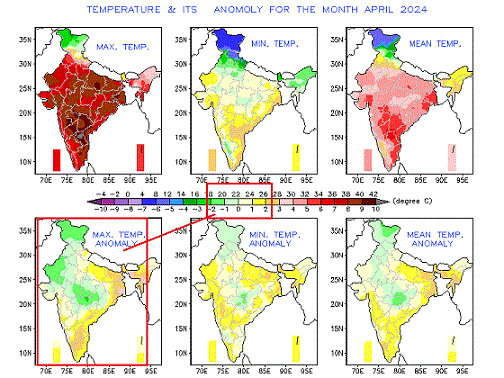
The "Climate Change" Theory...As Prophesized..👇

Seen Below, the temperature anomaly for the whole Month of April 2024 (In India) was in the " Green/Light Green/White Shade. That is upto 2c below Normal. The SE Coast is " Yellow" , around 2c above normal...NO Heat wave !

Was it really the worst Heat in April/May 2024 ? 2022 was Hotter !
Lets compare with last few Aprils: 2023

.gif)
Mumbai grumbles as seeing the "Hottest April" in 2024...Really ?👇See the "Average Red Line "


Posted 13th Evening....:
Thunder clouds developed and formed in the Eastern townships like Kalyan, Badlapur and Navi Mumbai on Monday afternoon.
In a sudden development, the thundery clouds drifted towards Mumbai, and due to the fierce intensity of the cloud, a strong "downdraft" roared downwards into the city and suburbs. The winds in gusts touched 60-70 kmph, like cyclonic winds.

Many parts of city were covered with dust due to the gales.
Few places in North, Eastern and Central Mumbai got the pre monsoon showers as expected.
Prominent rains till 5 pm : Badlapur 40 mms, Airoli 30 mms, Kopri IITM 28 mms, Marol 11 mms, Virle Parle 7 mms, Vagaries club 6 mms
Badlapur witnessed cyclonic winds at 106 kmph due thundery clouds at a height of 18kms..( 55000 feet)!

Mumbai rains in colour code as on 8.30 pm


18th July Rainfall in cms


