Sunday, February 24, 2019

Posted Sunday 24th February Night:

Due to F-5 moving East, and interacting with Easterly Moist winds, heavy thunder showers likely in Kolkata on Monday and Tuesday (50-70 mms). Very Heavy thunder showers in some parts likely on Monday.

With Western Disturbance F-5 moving away, we see another Back -to- Back WD coming in approaching our Sub Continent again (F-6) from 25th. 
Into Pakistan , F-6 will cover most of the Northern Regions and have precipitations down South till Sindh.
Karachi will get showers and light rains on Monday 25th and Tuesday 26th.

F-6 moves into India on the 26th, with good rains /snow in Kashmir, H.P. and Uttarakhand. Rains likely in the plains of NW India. On 26th, rains with hails, will occur in Punjab, Haryana, North Rajasthan, Delhi, West U.P. and Northern M.P.
Cool NW winds blowing across Saurashtra will bring cooler weather to Gujarat on Tuesday and Wednesday.

New Delhi will get showers , heavy in some parts, upto 10 mms, on Tuesday and some showers on Wednesday. Tuesday/Wednesday days will be cool around 19c. Nights will drop to 7-9c.

Jabalpur: Light rains likely on 27th Wednesday.

Mumbai: Saw the warm weekend with the maximum on Saturday and Sunday at 35c. Likely to start getting to 32c on Monday and pleasantly cool with below 30c temps in the day on Tuesday 26th and Wednesday 27th. Nights around 13-15c on 25th/26th. Windy evenings these two days.

Pune: Again, after a warm Saturday/Sunday recording 36c, Pune will start cooling down from Monday 25th. Tuesday/Wednesday will be cool, with minimum going down to 9-11c.

Another Back to Back Western Disturbance,  F-7, approaches our Region on 28th February ( In North Pakistan) and 1st March into India.


Thursday, February 21, 2019

As  "Earth warms,"  Michigan's  Upper  Peninsula  to  get  more  snow

See  the  Normal  Annual  Snowfall  increase  in  last  30  years...Mid Western States, U.S

Wednesday, February 20, 2019

F-5 Activity on Wednesday


Posted Wednesday 20th February 2019


The Ozone Hole: 

Closing the Gap

 Every day, as the Sun shines on the Earth, it sends ultraviolet rays that can cause sunburn and sometimes damage our DNA. Like a sunscreen for our planet, the ozone layer absorbs most of this harmful radiation and protects us. 
But in the early 1980s, scientists discovered that the ozone layer was thinning over Antarctica each August and September. 
In 1987, nations around the world came together to fix the problem through the Montreal Protocol. The international treaty banned the production of ozone-depleting chemicals like chloroflurocarbons or CFCs. But these chemicals had been in use for decades, and they stay in the atmosphere for a long time so it took a while to see the effects of the ban. 
In 2000, the ozone hole was the largest ever observed by scientists. 
But conditions slowly improved. Data from NASA and several partners showed a 20 percent decrease in ozone depletion during August/September from 2005 to 2016.

In 2017, the hole was the smallest since 1988. A year later, the hole was smaller than expected. Studies suggest that the ozone layer over Antarctica should mostly recover by the middle of the 21st century.
NASA Earth Observatory

See Video: https://youtu.be/6BUT16jfoKk

Tuesday, February 19, 2019

19th February 2019

Mumbai Water Supplying Lakes Storage:

As against a full supply position of 1447000 mlitres, the total storage on date is 608000 mllitres. That is 42% full from capacity. 
Todays supply is at the reduced rate of 3400 mltrs, so stock is for 178 days from date....that is upto 15th August 2019.

Info credit Vagarian Jayesh Mehta

Sunday, February 17, 2019

Posted Sunday 17th Night:

F-3 over North India now. Rains/snow expected next 2 days.
Delhi NCR; Moderate rains next 3 days. 
F-4, more intense approaches North India and NW plains on 20th. More Rains in North from F-4

Mumbai: Pleasant spell to subside..Gradual increase in warmth next 3 days. 
Pune/Aurangabad: Gradual heat up leading to 35c by Mid week. Wait for weekend !

Kolkata: Hot on Wednesday and Thursday to 35c...

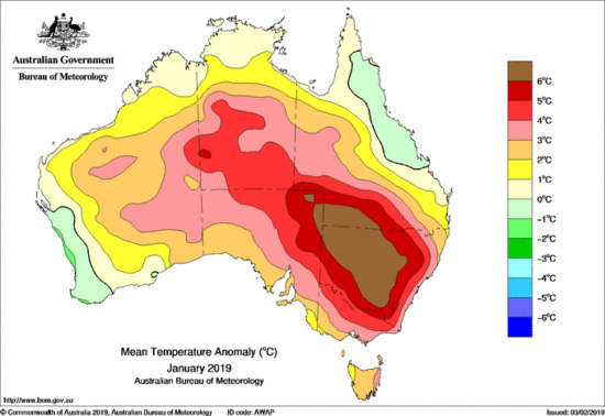
Australia’s Record Hot January: Mostly Weather, Not Climate Change

February 4th, 2019 by Roy W. Spencer, Ph. D.
The Australian Bureau of Meteorology (BOM) claims January, 2019 was record-hot. There is no doubt it was very hot — but just how hot… and why?
The BOM announcement mentions “record” no less than 28 times… but nowhere (that I can find) in the report does it say just how long the historical record is. My understanding is that it is since 1910. So, of course, we have no idea what previous centuries might have shown for unusually hot summers.
The assumption is, of course, that anthropogenic global warming is to blame. But there is too much blaming of humans going on out there these days, when we know that natural weather fluctuations also cause record high (and low) temperatures, rainfall, etc.
But how is one to know what records are due to the human-component of global warming versus Mother Nature? (Even the UN IPCC admits some of the warming since the 1950s could be natural. Certainly, the warming from the Little Ice Age until 1940 was mostly natural.)
One characteristic of global warming is that it is (as the name implies) global— or nearly so (maybe not over Antarctica). In contrast, natural weather variations are regional, tied to natural variations and movements in atmospheric circulation systems.
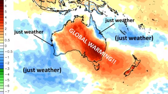
That “weather” was strongly involved in the hot Australian January can be seen by the cooler than normal temperatures in coastal areas centered near Townsville in the northeast, and Perth in the southwest:  


The extreme heat was caused by sinking air, which caused clear skies and record-low rainfall in some areas.
But why was the air sinking? It was being forced to sink by rising air in precipitation systems off-shore. All rising air must be exactly matched by an equal amount of sinking air, and places like Australia and the Sahara are naturally preferred for this — thus the arid and semi-arid environment. The heat originates from the latent heat release due to rain formation in those precipitation systems.
If we look at the area surrounding Australia in January, we can see just how localized the “record” warmth was. The snarky labels reflect my annoyance at people not thinking critically about the difference between ‘weather’ and ‘climate change’: 


January 2019 surface temperature anomalies (deg. C, relative to the 1981-2010 average) from NOAA’s Global Forecast System (GFS) analysis fields. Unlabeled graphic courtesy of WeatherBell.com.

So, the claims of the usual suspects such as “Australia’s Extreme Heat is a Sign of Things to Come” is just one more example of the blind leading the blind.

Wednesday, February 13, 2019

Posted Wednesday 13th Afternoon:

Western Disturbance F-2 is now almost over North India on Wednesday. Wednesday/Thursday will see the effect of an induced low forming over Rajasthan, and on Thursday/Friday the low attracts the Easterlies over North and Central India.
Resultant good rains/snow on Wednesday and Thursday in Kashmir, H.P, Uttarakahnad and rainfall in North Rajasthan, Haryana , Punjab and Delhi on Wednesday and Thursday.

Thursday Friday sees rains in the North and Central India regions of M.P, Vidharbh.

Jabalpur gets showers on Friday 15th. Temperatures showing a fall after that on Sat/Sunday.
Nagpur gets light rains to showers on Friday.
Temperatures drop in North/NW and Central India on Saturday/Sunday.
West also sees a fall in temperatures on the weekend.
New Delhi will get showers or thunder showers on Thursday and Friday. Cooling the days. Around 15-30 mms expected in 2 days.

F-3 will be appearing around 18th over Pakistan, with rainfall possible in Sindh from it.
F-3 approaches India on 18th/19th with more rains in the North.

Mumbai: Wednesday Thursday will be warm at 34/35c with nights around 20c at Scruz. Gradual cooling from Friday 15th, with the days cooling down to below 29c and nights may register 15/16c at Scruz.

Pune: Warm on Wednesday and Thursday. Cooling from Friday with weekend touching 9/10c.

Sunday, February 10, 2019

If the Polar Vortex is due to Global Warming, Why are U.S. Cold Waves Decreasing?

January 31st, 2019 by Roy W. Spencer, Ph. D.

It’s much easier to devise and promote a climate change theory than it is to falsify it. Falsification requires a lot of data over a long period of time, something we don’t usually have in climate research.
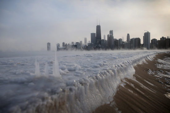
The “polar vortex” is the deep cyclonic flow around a cold air mass generally covering the Arctic, Canada, and Northern Asia during winter. It is irregularly shaped, following the far-northern land masses, unlike it’s stratospheric cousin, which is often quite symmetric and centered on the North and South Poles.
For as long as we have had weather records (extending back into the 1800s), lobes of cold air rotating generally from west to east around the polar vortex sometimes extend down into the U.S. causing wild winter weather and general unpleasantness.
We used to call this process “weather”. Now it’s called “climate change”.

When these cold air outbreaks continued to menace the United States even as global warming has caused global average temperatures to creep upward, an explanation had to be found. After all, snow was supposed to be a thing of the past by now.

In other words, as the theory goes, global warming sometimes causes colder winters. This is what makes global warming theory so marvelously adaptable — it can explain anything.
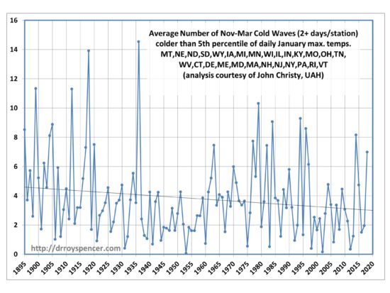
In the wake of the current cold wave, John Christy skated into my office this morning with a plot of U.S. winter cold waves since the late 1800s. He grouped the results by region, and examined cold waves lasting a minimum of 2 days at a station, and 5 days at a station. The results were basically the same.
As can be seen in the plot below, there is no evidence in the data supporting the claim that decreasing Arctic sea ice in recent decades is causing more frequent displacement of cold winter air masses into the eastern U.S., at least through the winter of 2017-18:


The trend is markedly downward in the most recent 40 years (since 1979) which is the earliest we have reliable measurements of Arctic sea ice from satellite microwave radiometers (my specialty).
Now, I suppose that Arctic sea ice decline could have some influence. But weather is immensely complex. Cause and effect is often difficult to ascertain.
At a minimum we should demand good observational support for any specific claim. 
In this case I would say that the connection between Eastern U.S. cold waves and Arctic sea ice is speculative, at best.
Just like most theories of climate change.

Saturday, February 09, 2019

Today Mumbai sees coldest morning of this season and also witnesses 2nd lowest temp in last 6 yrs for Feb month.

Pune also witnessed coldest morning of this season & also sees 2nd lowest temp in last 6 yrs for Feb month.


Also was lowest temp of season in parts of North Kokan & Madhya MH region in Maharashtra.


Some temp info in map format:


Above map prepared by Tejas & Data input by Abhijit


Nashik district stations min temp for today (Below 5℃) (09-02-2019):

Khedgaon (Dindori) 1.6℃
Pimpri (Niphad) 2.3℃
Mokbhangi (Kalwan) 2.4℃
Deogaon (Niphad) 2.5℃
Dangsaudane (Baglan) 2.6℃
Niphad 3℃
Dangsaudane (Baglan) 4℃
Nashik 4℃ (Is 2nd lowest temp in last 10 yrs for Feb month)
Taked (Igatpuri) 4.1℃
Kalwan 4.2℃
Abhona (Kalwan) 4.3℃
Satana (Baglan) 4.4℃

Above info compiled by Vagarian Shivkumar

Data courtesy IMD & Mahavedh

Friday, February 08, 2019

Posted Friday 8th Morning:
Mumbai:
Friday expected to be cool around 25/26c in the day. Saturday morning cold at around 12/13c. Day a couple of degrees higher at 28c. Sunday , again a bit warmer around 28/29c. 
Monday /Tuesday/Wednesday warm at around 33/34c, and nights rising to 19/20c.

Pune : Cool till Sunday, expected drop on Saturday to 8/9c. 
Next week warmer, with cloudy weather, and light rain in some parts on Tuesday/Wednesday.
------------------------------------------------------------------------------------------------

Posted Wednesday 6th Morning:
Mumbai can expect cooler days and nights till Saturday. Pleasant weather from 7th-9th with temperature range between 27/28c and 13/14c at Scruz.
So, a pleasant period from Wednesday....
Pune too will get cold at 8/9c from Wednesday

Monday, February 04, 2019

Posted Monday 4th February Afternoon:

The February Western Disturbance, F-1, is approaching.Will bring precipitation rain/snow in Upper Pakistan on 4th/5th, with some rainfall in upper Sindh regions.

On 6th, F-1 moves into India via the Western Himalayan route. The intense W.D. will bring heavy amounts of rain/snow in Kashmir, H.P. and Uttarakhand on 6th and 7th, while actually commencing from 5th February. 
Induced Low and subsequent wind confluence will result in 
Rain, thunder  and hail  also in Punjab, Haryana, Delhi and North Rajasthan and  U.P. on Wednesday 6th and Thursday 7th. With sharp drop in day temperatures.
Parts of Northern M.P. (Jabalpur- drop in day temperatures) will get light to medium rains on 7th.
Light rain expected in Vidharbh on 7th Thursday (Nagpur).

Mumbai:
Warm and partly cloudy on Monday. Monday/Tuesday days likely to be around 32/33c, with lows at 19/20c.
From Wednesday 6th, Mumbai can expect cooler days and nights till Saturday. Pleasant weather from 7th-9th with temperature range between 27/28c and 13/14c at Scruz.
So, a  pleasant period from Wednesday....

Pune

Warm on Monday 4th and Tuesday 5th, with partly cloudy skies and a bit more humid. Days around 32c.
But, better from Wednesday thru Saturday, with days dropping to 26/27c and nights to 8/9c on Wednesday and Thursday.

Saturday, February 02, 2019

Mumbai Scruz Average January Temperatures comparing last 3 years:

2019 >>   Avg Max: 31.3c    Highest 35.5c and coolest day 27.2c
               
                 Avg Min: 15.9c    Coldest 13.2c and warmest Night 19.2c.


2018 >>   Avg Max:  31.6c    Highest 35.6c and coldest day  27.2c
             
                Avg Min:   17.1c    Coldest  13.6c and warmest Night  21.8c


2017 >>  Avg Max    31.9c       Highest 35.8c  and coldest day  27.8c

                Avg Min:   16.3c       Coldest 11.9c and warmest Night 19.4c.


Pune Average January Temperatures comparing last 3 years:


2019 >>    Avg Max: 30.2c       Highest 33.1c and coolest day  26.5c

                 Avg Min:  9.9c         Coldest 6.9c and warmest night  12.2c

2018 >>    Avg Max:  29.9c     Highest  33.4c and coldest day  27.5c

                 Avg Min:   12.2c      Coldest  9.9c adn warmest Night   16.2c

2017 >>    Avg Max: 29.8c       Highest 32.2c and  coldest day   27.5c

                 Avg Min:  11.2c        Coldest 7.4c  and warmest 15.2c

  2nd December Post: The remnants of the erstwhile cyclone Fengal now lies over Karnataka as Well Marked Low. System will move West and emer...