Tuesday, August 31, 2021

Posted 31st August Morning:


How are the "Kings " doing this year  ...

Mawsynram: Jun-Aug: 7465 mms...Annual till Aug 8692 mms

Cherrapunji : Jun- Aug 6173 mms....Annual till Aug : 7498 mms

(Courtesy Gogoi ji IMD Guwahati)


Top 15 highest rainfall cities of Gujarat till 31st Aug (including Saurashtra)

1. Kaprada(Valsad) 1638 mm

2. Dharampur(Valsad) 1408 mm

3. Vapi 1397 mm 

4. Umergam (Valsad) 1332 mm

5. Khergam(Navsari) 1325 mm

6. Valsad 1271 mm 

7. Pardi(Valsad) 1235 mm

8. Ahwa(Dang) 1144 mm

9. Waghai(Dang) 1134 mm

10. Dolvan(Tapi) 1095 mm 

11. Navsari 1087 mm 

12. Mahuva(Surat) 1069 mm

13. Chikli(Navsari) 1011 mm

14. Jalalpore(Navsari) 987 mm

15. Gandevi (Navsari) 972 mm

Compilation by Vag. Shitij

Sunday, August 29, 2021

Posted 29th August Night:

BB-9 Location on Sunday Night:

BB-9 movement expected W/NW. 

Rainfall Outlook for the Week 30th Monday - 3rd September Thursday:

Rains expected on 

Monday 30th to increase and move into West M.P. (East M.P. getting rains now), and Vidharbh and parts of Maratwada.

Tuesday 31st, Rainfall increases in Marathwada, Madhya Maharashtra (Pune/Nasik) and parts of Gujarat Region. West M.P. and Eastern Rajasthan continue to get showers.

Wednesday 1st; Heavy rains expected in North Konkan (Mumbai) and North Madhya Maharashtra ( Nasik).

Wednesday 1st & Thursday 2nd September: Rains also expected in Gujarat Region and all parts of Saurashtra.

Kutch will expect on 2nd & 3rd  moderate showers. Much needed in this maybe last major spell for kutch.

---------------------------------------------------------------------------------------------------------------------------

Mumbai: The (almost ) dry spell expected to end with some rains (with possible thunder) on Tuesday 31st (getting around 25-50 mms on Tuesday).. Next week, Intermittent showers will continue on 1st and 2nd September.

Pune: almost dry spell to end, by Pune standards from Monday evening. Next week, 31stTuesday thru 2nd Thursday, Pune will see moderate showers with cool weather.

Aurangabad Region: Rainfall expected on Monday and more rains on Tuesday 31st August. Rainfall continues till Thursday, daily 10-25 mms). Cool weather. Good for standing crops and corn crop.

औरंगाबाद विभाग: सोमवारी पाऊस अपेक्षित आहे आणि मंगळवार 31 ऑगस्ट रोजी अधिक पाऊस होईल. पाऊस गुरुवारपर्यंत सुरू राहील, (दररोज 10-25 मिमी). थंड हवामान. उभे पिके आणि मका पिकासाठी चांगले.

Surat: Rains likely from Monday 30th evening, with heavy showers on Tuesday 31st. Moderate to heavy rains on 1st also. Cumulative Monday - Wednesday could be  45-80 mms.

Bharuch: Good to moderate showers in Bharuch from 30th Monday thru Thursday 2nd September.

Saurashtra & Junagadh region will get fairly good rains (15-30 mms/day) on 31st, 1st and 2nd Sept.

સુરત: સોમવાર 30 મી સાંજથી વરસાદની સંભાવના છે, મંગળવારે 31 મીએ ભારે વરસાદ પડશે. 1 લીએ પણ મધ્યમથી ભારે વરસાદ. કુલ સોમવાર - બુધવાર 45-80 એમએમએસ હોઈ શકે છે.

ભરૂચ: ભરૂચમાં 30 મી સોમવારથી ગુરુવાર 2 જી સપ્ટેમ્બર સુધી સારોથી મધ્યમ વરસાદ.

સૌરાષ્ટ્રમાં 31, 1 અને 2 સપ્ટેમ્બરે સારો વરસાદ (15-30 મીમી/દિવસ) થશે

Indore: Moderate rains on Monday 30th , but Heavy rains in Indore on 31st Tuesday, with the moderate showers on Wednesday.


Saturday, August 28, 2021

Posted 28th August  Afternoon


Mumbai Rainfall less than 5-15 mms as mentioned on 24th, due to "Break Monsoon" Conditions.

Colaba: Last 7 days..


Date
22-08-202123-08-202124-08-202125-08-202126-08-202127-08-2021 28-08-2021
Rain (mm)
14.81.60.24.81.43.20.0

SCruz:: Last 5 days


24-08-202125-08-202126-08-202127-08-202128-08-2021
Rain (mm)
11.70.00.00.05.2 

Friday, August 27, 2021

 Posted 27th August Afternoon: Much awaited Monsoon Revival. 

 Increasing rains expected in Kerala & Coastal Karnataka in next 2-3 (27th/28th/29th) days...

Due to: Mid level weak circulation over east central Arabian Sea and strengthening westerlies due to offshore trough, and some pull effect from Bay UAC.


(Vag. Shreyas)

Thursday, August 26, 2021

 Posted 26th August  afternoon:                 

 Mumbai/Pune /Aurangabad/ Kokan Water Storage                                                                (Snippets) ➡➡🠆🠆➡➡ ➡➡

Mumbai/Pune: 24th Published Forecast maintained of low rainfall 


Wednesday, August 25, 2021

Posted 25th August afternon:

Second time in this month  monsoon is observing ‘break’ conditions. (A prolonged break earlier in the 1st fortnight has already occurred over many parts of the country.) 

 Gujarat, Rajasthan, Punjab and Odisha have been impacted largely during this phase. (Bihar, Jharkhand and West Bengal have been the beneficiary and received moderate rains)

Despite rains over east and northeast India, the rainfall deficiency has risen to -9% and can reach -10% in a day or two. 
This August is heading for one of the worst hit monsoon month and can draw parallel with August 2009, a severe drought year.


Deficiency  in the main  monsoon month like August can adversely impact the seasonal performance.

Consolation: A cyclonic circulation is expected to form over Northwest Bay of Bengal on 27 th August. This system will pull the eastern end of monsoon trough southward and can reverse ‘break monsoon’ conditions. 

This cyclonic circulation will deepen and may turn into a low pressure area before moving inland on 30th August. 

The weather system will revive the monsoon activity around the weekend.

Tuesday, August 24, 2021

Posted 24th August Morning

Map Prepared by Vag.Tejas data from "Water Resources Dept"
Clouds decreasing...Animated Image from IMD as on Tuesday 24th Afternoon.

Reduced and very scanty ( less than 5 mms/day) rainfall expected next 4 days in Gujarat Region, Saurashtra , Kutch, Rajasthan, Haryana, Punjab and Delhi.

Forecast for 24th-27th August: 

Marathwada: Light rain/Thundershowers expected in Marathwada region (including Aurangabad district) on 24th and 25th August (5-10 mm/day average).  from 26th, only light rain in few isolated areas. Daytime likely to be warm. 

मराठवाडा: २४ आणि २५ ऑगस्ट रोजी हलका पाऊस/गडगडाटी पाऊस अपेक्षित आहे (सरासरी ५-१० मिमी). २६ ऑगस्ट पासून , तुरळक ठिकाणीच हलका पाऊस पडेल. दिवस गरम राहील.


Friday, August 20, 2021

Posted Friday 20th Aug Afternoon:

Outlook for the Weekend: 20th/21st /22nd August:

Mumbai: Friday will get some moderate showers scattered in parts of the city. 

Cloudy weekend with normal temperatures.

Saturday and Sunday will see a little increase in the chance of  showers and rains frequency . The occasional shower could be heavy. Around 15-35 mms/day.

No Alerts.

Pune: Cloudy skies with a few showers, and pleasantly cool evenings with minimum around 21c.

Aurangabad district: Showers will continue this Saturday and Sunday. Beneficial to standing crops. A slight decrease from Monday in rainfall.

औरंगाबाद जिल्हा: शनिवार आणि रविवारी सरी सुरू राहतील. उभ्या पिकांसाठी फायदेशीर. सोमवारपासून पावसामध्ये किंचित घट.

Gujarat region (Surat/Bharuch/Ahmedabad ) will get moderate to fair rainfall during Saturday and Sunday. Anything between 5-20 mms/day.

Saurashtra Peninsula will get patchy showers , scattered in the region.

ગુજરાત પ્રદેશ (સુરત/ભરૂચ/અમદાવાદ) માં શનિવાર અને રવિવાર દરમિયાન મધ્યમ વરસાદ પડશે. 5-20 મીમી/દિવસ.
કાઠીવાડમાં છૂટોછવાયો વરસાદ પડશે,

New Delhi; Chance of showers and rain periods on the weekend . Temperature range between 33 - 26c.

M.P.  has Good chances of rainfall during the weekend.  

Indore Will get moderate showers on Saturday and Sunday, around 15-25 mms/day. Cool days at 26c.

Jabalpur too can see some moderate rains this weekend.

Chennai: Received some rainfall on Thursday with A.P. getting 11 mms, seasons total at 320 mms while city got 4 mms , the total at 344mms. 

A few light to moderate showers expected on the weekend.

Sunday, August 15, 2021

Posted 15th Night:

Gujarat:

The present Monsoon rains situation in Gujarat is not at all encouraging....

And the Numerical deficit:


Karjan Dam. At 50.61% of its live capacity, Dantiwada Dam. At 8.71% of its live capacity, Dharoi Dam. At 36.99% of its live capacity, Kadana Dam. At 44.05% of its live capacity, Watrak Dam. At 35.87% of its live capacity,  Damanganga Dam. At 62.95% of its live capacity, Ukai dam at 65%  of its capacity, 

Outlook: 

With such large deficit, the outlook needs to be extra good , to wipe out the negative. 

But, we see very little rain in all Gujarat and Saurashtra Regions on 16th & 17th , Monday /Tuesday.

18th , there will be increase in rainfall in South Gujarat Regions {Surat ( 20-40 mms/day), Valsad & Bharuch ( 20-30 mms/day), ...upto Vadodra}

19th & 20th we see the increase rainfall going into North Gujarat Region, with moderate showers upto Ahemdabad . Part and pockets in Saurashtra will get patches of  rainfall.

Patan will be hot, with little rain (upt0 15 mms) on 18th.

Decrease  (lesser rainfall) on 21st & 22nd.

આટલી મોટી ખાધ સાથે, નકારાત્મકને દૂર કરવા માટે, દૃષ્ટિકોણ વધુ સારો હોવો જરૂરી છે.

પરંતુ, 16 અને 17, સોમવાર /મંગળવારે તમામ ગુજરાત અને સૌરાષ્ટ્ર ક્ષેત્રોમાં ખૂબ ઓછો વરસાદ.

18 મી, દક્ષિણ ગુજરાત ક્ષેત્રોમાં વરસાદ વધશે {સુરત (20-40 મીમી/દિવસ), વલસાડ અને ભરૂચ (20-30 મીમી/દિવસ), ... વડોદરા સુધી}
18 મીએ થોડો વરસાદ (15 મીમી સુધી) સાથે પાટણ ગરમ રહેશે.
19 મી અને 20 મીએ વધારો વરસાદ ઉત્તર ગુજરાત પ્રદેશમાં જશે, જેમાં અહમદાબાદ સુધી મધ્યમ વરસાદ પડશે. સૌરાષ્ટ્રમાં ભાગ અને ખિસ્સામાં વરસાદના ઝાપટા પડશે. 21 અને 22 મીએ ઘટાડો (ઓછો વરસાદ).

 Posted 15th August Afternoon

मराठवाडा आणि विदर्भासाठी हवामानाचा अंदाज:


आतापर्यंत ऑगस्ट महिन्यात जास्त पाऊस झाला नाही, मात्र आता पुढच्या काही दिवसात मान्सून देशाच्या काही भागात पुन्हा सक्रिय होणार आहे. 


उद्या १६ ऑगस्ट पासून मराठवाडा आणि विदर्भ भागात पावसाचे प्रमाण वाढण्याची शक्यता आहे. १६ तारखेला मराठवाडा आणि विदर्भाच्या पूर्व भागात हलका ते मध्यम पाऊस अपेक्षित आहे (५-१५ मिमी). १७-१८ ऑगस्ट या दरम्यान बर्‍याच ठिकाणी हलका ते मध्यम पाऊस अपेक्षित आहे (१०-२० मिमी), व याच काळात विदर्भाच्या पूर्व भागात काही ठिकाणी मध्यम ते जोरदार पाऊस पडू शकतो (३०-६० मिमी). 


पिकांसाठी हा पाऊस उपयुक्त ठरेल.

Friday, August 13, 2021

Posted Friday 13th Evening:

Weak monsoon conditions are currently in August over large parts of the country. The rains are weak along the West Coast, Rajasthan, Maharashtra and  Peninsula. 

Weak monsoon conditions will last till 15th August and Monsoon is expected thereafter to improve. 

An off shore trough is likely to form off East Coast, extending from Bangladesh to Andhra Pradesh. Embedded in this, a cyclonic circulation will form over Northwest Bay of Bengal on 15 th August. 

This  system will become more marked and also move inland .This may further travel deep over central parts and later  northern parts of the country.

Hence increase in the rainfall along Maharashtra, Goa & Karnataka coast after Monday 15th/16th.

Mumbai will also see simultaneous increase. 

Wednesday, August 11, 2021

 Posted Wednesday 11th evening:

Mumbai:                                                                   (Chennai Below)

The outlook for the next 4 days till 16th does not promise any major improvement in rainfall for Mumbai. This weekend will get Scattered passing showers and sunny spells. Hot and humid. 

This is the daily rainfall in Mumbai Colaba from 5th August to 11th August..Daily..and just 29 mms in last 7 days 

COLABA - IMD OBSY5.62.82.20.03.20.00.029.0

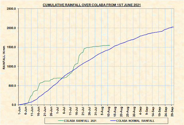
The Cumulative total graph is now flattening, moving towards the Blue line, the Normal level...and may cross it to go into deficient region if this continues.


Daily rainfall at Scruz in last 7 days:

SANTACRUZ - IMD OBSY3.80.10.62.60.50.20.043.4

Mumbai Scruz also had just 43 mms in the last 7 days. Though the graph has flattened, the overall total level is above the normal.


Pune
With the same less rainfall in the last 7 days, 15 mms,  
PUNE CITY - IMD OBSY3.70.30.00.10.00.00.914.5
Not much to see in terms of meaningful rain, with a few light showers in parts. A moderate shower possible on the weekend. Cooler nights.

Long Holiday Weekend coming up: 
Mahableshwar will have reasonable travel weather. Limited rainfall, with short hevy falls, around 20-30 mms/day, with some short sunny periods and foggy weather with a pleasant temperature range between 20c - 16c.

Khandala/Lonaval: Partly cloudy and patchy fog. Pleasant weather with short heavy falls & periods of rain. Reasonable weather to travel. 

Aurangabad District will have very less rainfall in the next 5 days, just some scattered rains. 
Need to secure the existing standing crops from the drying soil. s yet, the standing crop is satisfactory.
Pics from the Fields as on yesterday. Sent by Shyam Sonne (Farmer)


Chennai:
(North T.N.Coastline) Expected to get some moderate thundershowers on 12th & 13th. Rest of the weekend may see some decrease thereafter.

Sunday, August 08, 2021

Posted Sunday night 8th August:

Mumbai: The wait for the proper revival of the Mumbai Monsoon will continue as no major increase seen from 8th - 13th at least. 

Partly sunny and warm weather with few passing showers. No major prolonged spell. 

Water position comfortable till May 2022.

Pune: No major meaningful spell of rain next 5 days. In fact warmer days ahead. 

Marathwada: Very little rain with scattered rain. Warmer days. 

मराठवाडा: विखुरलेला खूप कमी पाऊस. गरम दिवस.

-------------------------

The BB 7 system finally  fizzles out.. Towards the Western Himalayan region. 

Overall break monsoon conditions are expected over the country. 

In break monsoon, the monsoon trough over north India shifts to Himalayan foothills. This will result in increase in rainfall over parts of Bihar, northern West Bengal, and entire eastern Himalayas and northeast India. 

Also, weakening of westerlies over south peninsula will result in wind convergence over parts of Tamil Nadu, resulting in propagation of an Easterly wave. This would bring rains to coastal TN. (Chennai) around 13th,14th.

Assisted by Vag. Shreyas

Saturday, August 07, 2021

Friday, August 06, 2021

Posted 6th  Evening:

Rajasthan's Eastern districts & West M.P. face excessive Rains..near the Annual Normal by August. expected to continue in the Region for another Day, before the system fizzles out.


Latest Friday Evening Lightning Image


Tuesday, August 03, 2021


 औरंगाबाद जिल्ह्यात पुढील 4 दिवस (3rd - 6th) कमी पाऊस पडेल. वादळी हवामान. तापमान अधिक गरम होईल.
पिकांची काळजी घ्या

Monday, August 02, 2021

 Map by Vag. Tejas...Source "Mah. Water Respources Dept"

2nd august 2021


Sunday, August 01, 2021

 Heavy Rains ( Mentioned in yesterday's snippet) as on 1st August Morning: 

East Rajasthan: Ajmer 137 mms, Bhilwara 75 mms, Jaipur 62 mms, Kota 44 mms, S.Madhopur 43 mms, Alwar 31 mms.

East U.P.: Churk 111 mms, Prayagraj 91 mms, Varanasi A.P. 47 mms, Lucknow AP 36 mms.

Delhi: Ridge 127 mms, Ayanagar 40 mms, Palam 29 mms, S'Jung 28 mms. Lodhi Road 27 mms.


Let's look into the 3rd week of March ( 17th - 21st). Mumbai : Hot weather likely for Mumbai region this week, typical dry hot days of M...