
Pune Shivajinagar has recorded 252 mm this June, making it the wettest June in a decade. Data: IMD
Daily rainfall variation in Pune in June 2024 is as follows

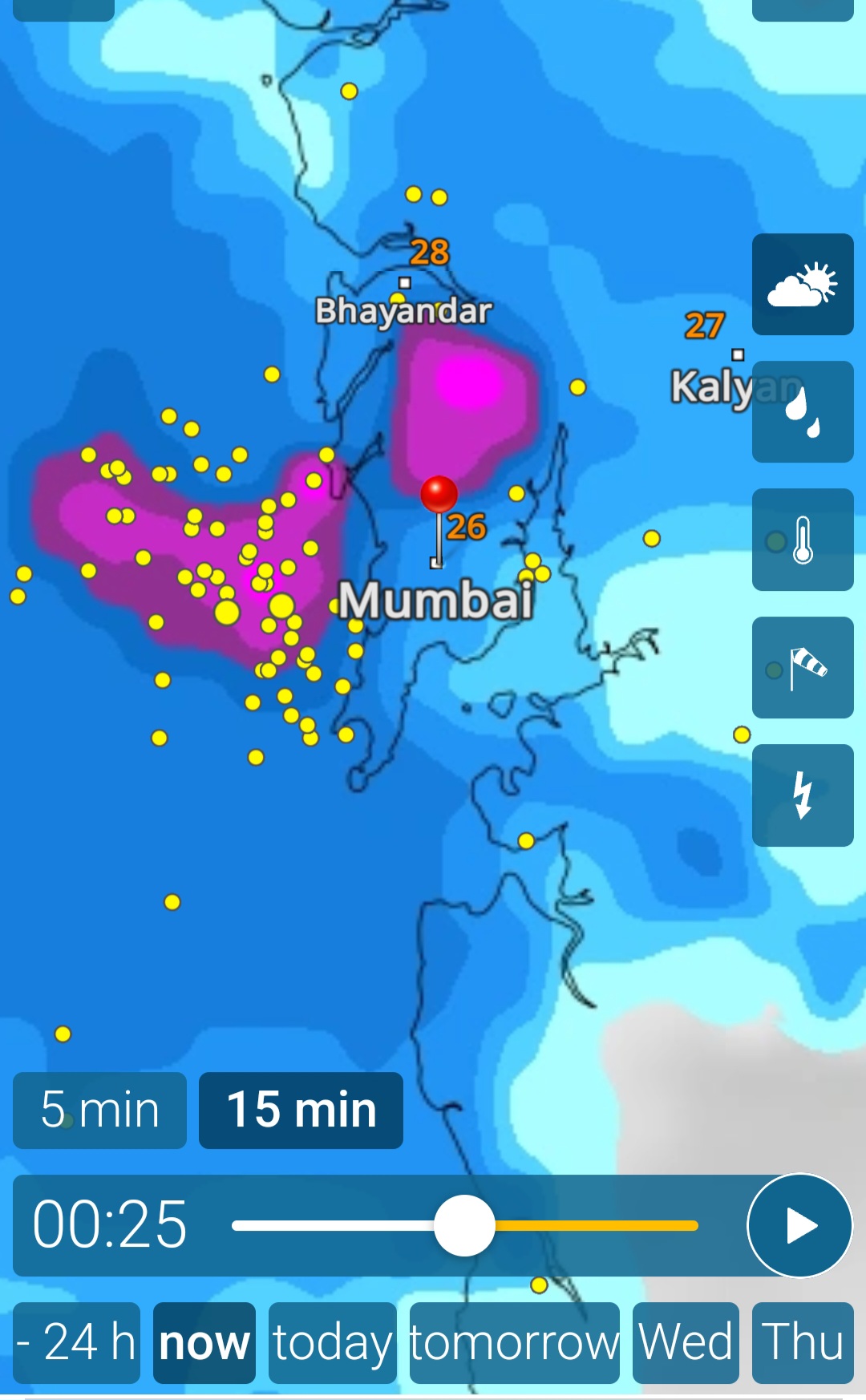
27th Morning
Rains in cms in Ghats and Mumbai Lakes
Ghat: Tamini-9, Dungarwadi-7, Dawadi,Bhira,Ambone -6 each , Shirgaon-5 , Koyana (N)-4, Wangaon,Dharavi, Lonavala(T)-3 each , lonavala(O),Walvan ,Thakuwadi,Koyna(P) ,Shirota- 2 each , Shirota,Khopoli,Khan -1 each
Lake : : Tansa-5,Tulsi-4 ,Mid Vaitarna,Vihar,Bhatsa-3 each ,Vaitarna-2,Upp Vaitarna-1
Karnataka Rains in cms👇

The rains in Mumbai have kept the commitment...to start with 👌( as per last posting): (Hope at least to achieve 3 days cumulative rainfall targeted)
Indications are that current spell of rains can extend upto 30th June.
24 hrs Rains as on 27th morning
IMD Colaba 47 mms
Memonwada & Nariman Pt 39mms
Aarey 37 mms
Malabar Hill 34 mms
Colaba &Dadar 32 Mms
Bandra 29 mm
Vagaries 28 mms, Versova 28 mms.
Worli & Powai 26 mms
IMD Scruz 14 mms
Mumbai Special: What to expect in the remaining days of June?
24th June data 👇:
Colaba: Though it seems less, Colaba has received 80% of the normal rainfall as on date. ....328 mms received.
Now, this is 64% of the total June normal.
Santacruz: Suburbs have received 52 % of the normal rains as on date. ...200 mms. Definitely less.
This is only 38% of the expected total on June 30th.
There are 6 days to reach the normal June figures of 526 mms ( Scruz) and 506 mms ( Colaba).
Is it possible?
Mumbai will see an increase in rainfall from 26th to 28th.
How much ?
26th-28th will probably get approximately 140 - 170 mms cumulative rainfall.
That would still keep Mumbai rainfall in month end deficit for June of around -10%.
Lakes:
The Mumbai lakes are largely deficit at 5.3% of the storage on 22nd June.
Expectations are that till June end it would average another 150 - 200 mms in the catchment.
Hopefully it should increase the storage by another 10%.
If it happens so ( another 10% additional storage), city supply could be good till 10th August.
23rd June
After a record 39 days (14may-21june), delhi safdarjung recorded below 40c temperature
Data From Vag. Vineet☝
----------------------------------------

Big cloud patch over the Arabian Sea has given rise to a UAC at 500 hPa over the Sea.

This is likely preventing the onset of strong westerly winds over the west coast and Ghats, delaying the predicted heavy rains.
Doppler weather radars of Goa, Kochi and Thiruvananthapuram do not show strong westerly winds over the coast yet.
This scenario was not forecasted by any of the leading weather models.
Vagaries will continue to provide regular updates on this.
From Vag Shreyas
22nd June
#Raigad district rainfall ending 8:30am in mm:
#Karanjwadi: 156
#Wava: 145
#Sanderi: 140
#Tala: 124
#Kolad: 122
#SudhagadPali: 116
#Mhasala: 110
#Pabhare: 105
#Nate:103
#Kalote: 97
#Roha: 94
#Poladpur: 78
#Mahad: 69
#Panvel: 59
#Mangaon: 56
#Karjat: 42
#Ratnagiri district massive rainfall figures ending 8:30am in mm:
#Mandangad: 205
#Makhjan: 202
#Palgad: 190
#Kadwai: 174
#Chiplun & #Wakawali: 150
#Savarde: 148
#Rampur: 128
#Kalkavane: 121
#Dabhil: 119
#Kherdi:117
#Khed: 93
#Devrukh: 78
#Cherrapunji seasonal total till now (From 1st June - 22nd June 2024) stands at 2542mm ( 102 ")!
Last year till same date (22nd June 2023) seasonal total was 2021mm
21st June
Mumbai water situation is precarious no doubt.
City lakes have just 77132 million litres in stock on 20th....maybe enough for 30 days with cut in force. Reserve stocks have been dipped into. State reserve stock from the Upper Vaitarna & Bhatsa dams have been drawn into.
Comparison with last 10 years on date

Mumbai Special
A recovery " of sorts," in the Mumbai rains
By 20th morning, Mumbai suburbs received unexpected heavy rains...like 👇
Some readings in mm below ending 8:30am 20th:
Palghar: 83
Naigaon: 56
Bhayandar: 84
MiraRoad: 99
Dahisar: 141
Borivali: 171
Kandivali: 126
Malvani: 133
While in Santacruz received 18mms, Vagaries ( Mahalaxmi) 26 mms, Colaba 29 mms.

19th Night
Hottest Weather in North India Persisting relentlessly....


New Delhi witnessed on 19th morning, the worst Night temperature ( minimum) as Safdarjung recorded a low of 35.2°c
Incidentally it's beats the previous hottest Night record of 34.7°c.

Delhi is witnessing one of its hottest summer in many years...a display of temperatures this June👇


17th June Evening
Gujarat:
Heavy pre monsoon showers lashed parts of Saurashtra on 16th ...in cms

As Monsoon advances into Gujarat region and Coastal Saurashtra on 22nd/23rd, Substantial increase in rainfall in South Gujarat coast from 22nd..( Valsad /Surat).
Bharuch: Max today 38.5°...minimum 29.5°.
Rains likely to increase from 22nd. as Monsoon advances.
Surat: Max 35.7°...Minimum 30.0
Valsad : Max 36.2°...Min 22.4°
Rainfall expected to increase from 22nd.
17th Afternoon Post:
Extremely heavy rain is expected over Northeastern states over next few days.
Cherrapunji has received 1924 mms in June till date.
Floods expected in the Brahmaputra river basin.
Sikkim and Darjeeling to also get very heavy rains.
From Vag Dr.Vineet Singh 👇
An unusually long stretch of heatwave in west UP, Delhi NCR
Generally heatwaves are seperated by strong squalls every summers, and a single heatwave spell does not last more than 6-7 days, but this summer has been exceptional for delhi ncr west UP
High chances the average maximum temperature of delhi this june will break all june records, ~30 days in a row now with delhi maxiumum temperature >40c, this is very rare, and is due to lack of strong WDs, squalls
One theory which I challenge every season and is highly doubtful and need to be reconsidered:
The role of seasonal low over North India in monsoon advancement
Many times below normal heat in may june but monsoon advances north quickly
While other times lots of heat like this summer, but monsoon ka ata pta nahi
This shows that rather than seasonal low, there is MJO, biso which plays a more important role in the northward advancement of monsoon
15th Night Post


Can expect some relief soon.
Today we see " no monsoon trough" scenario.

A change starting June 19th, with the trough getting into formation stage from 18th, the arrival of the monsoon expected by June 20th or 21st.
15th Morning

Mumbai :Monsoon to remain weak along Mumbai/Thane and konkan coast for next 4-5 days...and gradually strengthen after 20th June. Only passing showers/localized thundershowers likely with sunny periods in the day. Hot and humid weather.
Not helpful for water stock in the lakes.

Colaba:198 mms
WSC Vagaries: 188 mms
Santacruz: 128 mms
Gradually strengthen from 19th
Last week of June and early July can see heavy rain.
Pune: Due to weak westerly winds of monsoon, afternoon/evening showers/thundershowers likely for next 3 days in parts of the city and district. Localized moderate/heavy showers likely and rainfall will not be uniformly distributed.
Interior Maharashtra: Chance of moderate rain/thundershowers in Madhya Maharashtra, Marathwada and Vidarbha region. Districts such as Pune, Ahilyanagar, Nashik, Satara, Sangli, Solapur, Jalgaon, Ch. Sambhajinagar, Jalna, Buldhana, Beed, Dharashiv, Nanded, Akola. Amravati, Nagpur can receive light to moderate rain. Few pockets can receive moderate-heavy showers, but not well distributed.
13th June Morning
Mumbai:
June summery: The average daily maximum temperature was 34c. At night it cooled down to temperatures between 27°C and 29°C. 4 days of rain.
Monsoon reaches Mumbai..and weakens !
Not much of meaningful rains expected this weekend 14th - 17th June. Passing showers or localised rains in parts of Mumbai. Unlike a full fledged Monsoon onslaught.
Sunny periods will add to the discomfort with high humidity prevailing and stuffiness at night.
The absence of a strong off shore Monsoon trough ( Along Maharashtra Coast) and weak South West winds are the main cause for this " lull"
Expected recovery maybe by middle of next week, after 18th June..
11th June Afternoon
As per our calculated assumptions, the Monsoon advanced into Mumbai region on 11th...( with heavy thundershowers on 10th night).
The Monsoon has made a formal entry into Mumbai/Pune.
Mumbai:
Monsoon will now be in "moderately easy" mode, this week.
Intervals of clouds and sunshine with a couple of showers or a thundershower.
Days may be lower at 32°, but may feel like 35°. Very humid conditions.
Pune: Partly cloudy and light to moderate rains in parts of city. Even with temperatures around 31°, the "rea feel" will be 35°
The soil moisture, in Madhya Maharashtra and Marathwada, initially has sunk in upto 6 inches in the fields, perfect for sowing operation. Lesser rains in interior Maharashtra farmland for next 5/6 days should be ok for crops..

Now, from 11th to 18th, the Monsoon winds are seen weakening for Maharashtra, due to shifted Shear Zone, lack of off shore trough support, Anti Cyclone in interior...at 700 levels.

.
10th June ..Morning

Although it is large scale monsoon moisture effect, the upper wind pattern remains northerly over Mumbai due to UAC over South interior Maharashtra...so Mumbai SWM onset declaration by Vagaries is not done.
We expect , at least the surface and 850 winds to gain as westerlies over Mumbai region around 11th. Monsoon could be advanced on 11th
Initially, after 11th, Monsoon rains will be moderate (not strong) over Mumbai...for a week.
Top 5 rainfall amounts in Mumbai (BMC)
*at 11.55pm*

*N.M.Joshi Marg Mun. School *Lower parel : 132 mm*
Britania storm water pumping *Darukhana :128 mm*
SWD Workshop *Dadar West: 120 mm*
F South Ward Office *Dadar East: 117 mm*
Tagore Nagar *Vikhroli :109 mm*
Mumbai:
Monsoon now advancing towards Mumbai:
Received pre monsoon showers on Saturday night. This is due to the UAC stationed at S.Konkan and brought in moisture. UAC expected to move away, and result in NW winds, which can stall the Monsoon by another 24 hrs over Mumbai.
Metropolitan Region got good thundershowers overnight! Below are some readings ending 8:30am : BorivaliWest (Vag Nilay Reading): 59 DahisarWest: 58 Aarey: 54 JogeshwariEast: 45 Magathane: 43 Powai: 34 Andheri: 33 MulundWest: 32
Pune lashed by heavy rains:
Pune Shivajinagar: 117.1mm in last 24hrs
This is the highest 24hrs rain in June after 1991. Highest ever in June is 132 mms in 1961
Pune got 64% of normal June rain in just 1 day.
Pune June total now 209.2mm and already exceeded the total June normal rain quota (184mm).
Pune rainfall readings of 24 hrs ending 8:30am in mm:
1.Shivajinagar IMD: 117, 2.SadashivPeth: 113
3.Kothrud: 106, 4.SinhagadRoad: 96
5.Bibwewadi (Vag Abhishek Reading) & Pashan: 81
6.NDA: 72, 7.Kharadi: 50, 8.Magarpatta: 43
Monsoon advances further into S Konkan region! 👇


Resulting rainfall readings below ending 8:30am today in mm:
1. Mulde 207 , 1(a). Kudal: 197
2. Amboli: 179, 3. Masure: 169
4. Sawantwadi: 165, 5. Pinguli: 149
6. Vetore: 147, 7. Vengurla: 143
8. Devgad: 136, 9. Walaval: 120
10. Kasal: 112, 11. Ratnagiri 107
Ratnagiri district rainfall figures ending 8:30am in mm:
1.Pawas: 149, 2.Aabloli: 137
3.Nate: 123, 4.Ratnagiri: 107
Raigad district rainfall figures ending 8:30am in mm:
1.Alibag: 109, 2.Poladpur: 104
3.Mahad: 103, 4.Kihim:73, 5.Pen:60
Data Credits: Agri Dept: Compiled by Vag. Abishek Apte
More Rains from Maharashtra in mms
Satara 61
Mahabaleshwar 41, Matheran 32,
Ahmednagar 20, Sangli 19
Kolhapur 17, Solapur 12
Posted on Saturday 8th June Afternoon.
Moist 700 mb trough (east -west)to propagate north with cyclonic circulations seen developing on the poleward edge of monsoon current. Monsoon to strengthen in South Maharastra in the next 48 hrs.


Widespread heavy rains expected over western Maharashtra.
---------------------------------------------------------------------------------------------------------------
Mumbai: Mumbai Region got a repeat of Pre Monsoon Showers on Saturday Morning.
Rainfall in Mumbai expected to increase from Saturday Night. Sunday will see showers increasing with good rains on Monday /Tuesday as the Monsoon sets in properly. (40-60 mms/Day expected).
Day temperatures to ease by 2/3c.
This is a moderate beginning of the Monsoon..NO ALERT.
-----------------------------------------------------------------------------------------------------------------


Meanwhile....Monsoon advances into Coastal Karnataka, Interior Karnataka with super heavy rains !
Resulting Rainfall today👇
UTTARAKANNADA District
-----------------------------------
KUMTA - 360.7 mm
HANEHALLI (KUMTA) - 252.5 mm
HALDIPUR (HONNAVAR ) - 248.5 mm
HEGDE (KUMTA)- 243 mm
KADATOKA (HONNAVAR) - 238.5 mm
BOBRAWADA (ANKOLA) - 237.5 mm
KARKI (HONNAVAR) - 234.5 mm
KALBHAG (KUMTA) - 233 mm
DEVAGIRI (KUMTA) - 225.5 mm
BELAMBAR (ANKOLA) - 222 mm
AGRAGONA (ANKOLA) - 218 mm
VANDIGE (ANKOLA) -217 mm
TORKE (KUMTA) - 215 mm
SAGADAGERI (ANKOLA ) - 204.5 mm
GOKARNA (KUMTA) - 202 mm
ANKOLA - 200 mm
BLALE (ANKOLA) - 195.5 mm
SHETAGERI (ANKOLA) - 190 mm
HOSAKULI (HONNAVAR ) - 186.5 mm
HIREGUTTI (KUMTA) - 186 mm
CHANDAVAR (HONNAVAR ) - 183 mm
MAJALI (KARWAR) - 181 mm
KADLE (HONNAVAR) - 179.5 mm
DEEVGI (KUMTA) - 177.5 mm
ALAGERI (ANKOLA) - 171 mm
SALKOD (HONNAVAR ) - 166.5 mm
BHAVIKERI (ANKOLA) - 159 mm
MUGWA (HONNAVAR ) - 153.5 mm
KADAWADA (KARWAR) - 152 mm
MOGATA (ANKOLA) - 150 mm
UDUPI DISTRICT
--------------------
PADUVARI (KUNDAPUR) 155.5 mm
KERGALU (KUNDAPUR) 130.5 mm
GOLIHOLE (KUNDAPUR) 110 mm
SHIRUR (KUNDAPUR) 105 mm
KALTHODU (KUNDAPUR) 104 mm
UPPUNDA (KUNDAPUR) 93.5 mm
KAMBADKONE (KUNDAPUR) 89 mm
HAKLADI (KUNDAPUR) 85.5 mm
BIJUR (KUNDAPUR) 83.5 mm
MARAVANTHE (KUNDAPUR) 81.5 mm
HEMMADI (KUNDAPUR) 81 mm
CHITTURU (KUNDAPUR) 78.5 mm
KIRIMANJESHAWARA (KUNDAPUR) 77.5 mm
VADDARSE (UDUPI) 76 mm
GANGOLLI (KUNDAPUR) 75 mm
AJRI (KUNDAPUR) 74 mm
MOLAHALLI (KUNDAPUR) 73 mm
INNA (KARKALA) 72.5 mm
AGUMBE - 42 mm
Compiled by Naveen Reddy
Data Credits: KSNDMC
5th June Post


Monsoon Watch---
Typical Monsoon Advance Signature ( Over Kerala) seen in today Morning's Satellite Image


Mumbai:
 Mumbai Santa Cruz saw, a record 18 Nights ( 18th May - 4th June ) of Minimum temperatures of 29c or more. A record streak as per Vagaries. It peaked on 3rd June , when the "Low" touched 30c.
2nd June...
We want to change the Tune...Enough of "Heat" News😠!

The U.K. situation is set to change dramatically with the arrival of a cold front.
Weather maps predict that Glasgow will experience snowfall on June 4, which is unusual for this time of year. Other areas are expected to experience rain showers.
This wintry weather will persist for two days
By Arezki AMIRI (EC Nostrum)
2nd June Night:
Monsoon Watch -

The surface winds need another 24 hrs to establish:

The lower level Monsoon winds are taking a long time to set in over the Kerala region.

The uppermost Jet Stream is properly established.

South Karnataka Monsoon set by 6/7th June
Mumbai:
With a record streak of unrelenting high temperatures and humidity, the city awaits some relief.
Pre Monsoon thundershowers in late afternoon expected from 4th June. Not to be mistaken for Monsoon though.
Monsoon should set in by 11th June.
Pune:
Pre Monsoon late afternoon thundershowers expected from 4th June. Monsoon should set in by 11th June.
Goa: Expect pre monsoon showers from 3rd June.. Fairly good, around 15-20 mms /day. Frequency increasing daily. Monsoon should set in by around 8th/9th June.
Sambhajinagar (Aurangabad): Pre Monsoon thundershowers expected from 4th June. Not to be mistaken for Monsoon.
Sowing should be not started before 14th June.as the seeds may not germinate with scattered pre monsoon rains.
Gujarat: Hot and Dry. No rains expected till 11th at least.
Bharuch Max on 2-06-2024: 38.2c
Min: 28.4c
Expect around 40c next week,
9th May Night Post 👇 No Warnings... All Temperatures in +_ 1° of normal range. Mumbai : Hot and humid.. Making Real Feel of 39°.. Day: ...


