Friday, May 31, 2019

Mumbai Lake Levels as on 31st May 2019: In Mls
Modak Sagar 44462, Tansa 14777, Middle Vaitarna 36072, Bhatsa 47853, Vihar 1576, Tulsi 2269
Total 147010....Supply per day is 3450 ( after the cut), so Stock only till around 15th July.
Info from Jayesh Mehta Posted Friday 31st May Evening:

The South West Monsoon has advanced into the Maldives area and the Andaman Sea.
It is likely to move into Sri Lanka by 3rd June as a weak current.
Monsoon current may then intensify from 4th , and Kerala could have hopes of Monsoon arrival by 6th June. A low pressure may form in the Lakshdweep region around 6th June.
Further push into Coastal Karnataka likely after 6th June...and South West Monsoon may enter Coastal Karnataka around 7th June. 
Possible chance of current weakening a bit then.( For a few days).

{Next 4 days:
Mumbai: Partly cloudy, with very humid conditions. Temperatures around 34c, but the real feel will be around 41c. Light rain and drizzles possible in some parts of city on 3rd and 4th June. Regular Monsoon onset not before 14th June as explained earlier.

Pune: Hot at 37/38c. Very windy. There has been a total absence of any pre monsoon thunder activity in Pune in May....Unusually dry and hot. First pre monsoon showers not expected before 4th June.

Mahableshwar: An unusually dry and hot May this year for this Hill Station. With 0 mm of rain, it is the driest May in more than 10 years. This Station should normally get around 50 mms in May. The day temperatures which should normally be around 29c, are hovering around 34c ! ...and no relief seen in the next 4 days.}

--------------------------------------------------------------------------------------------------------------------------

Heat Wave in major parts of North, North West, Central India and Central Peninsula continues.

On 31st Friday, Sri Ganganagar 49.6c (Record for this place is 50c in 1934), Churu 48.5c,  Jabalpur 46.8c (All time high), Rewa 46.8c, Nagpur 46.5c,  Chandrapur 46c, Agra saw a high of 45.5c, 

The 10 Hottest Spots in the World  Recording of all stations is of 31st May. Heet and Banda 
is 30th May...
1Heet (Iraq)
52.5°C
2Jacobabad (Pakistan)50.1°C
3Ganganagar (India)
49.6°C
4Churu (India)
48.5°C
5Banda (India)
48.2°C
6Matam (Senegal)48°C
7Bahawalnagar (Pakistan)
47.5°C
8Nowgong (India)47.2°C
9Rohri (Pakistan)
47.1°C
10Sibi (Pakistan)47.1°C

Actual Readings at 14.30 Friday in the Heat Wave Regios (Not Max)

Wednesday, May 29, 2019

Posted 29th May Night:

{Next 4 Days:
Mumbai:  Hot, Humid and sweaty ! Uncomfortable high humidity real feel of 41c. Light Pre Monsoon drizzles /rain from 3rd/4th June.
Pune: Hot at 39/40c, with gusty westerly winds in the day. }

"Too much of choice in any form leads to confusion".....And that is what is happening with amateur meteorologists today who are following the Monsoon development in various wind, pressure, upper winds and various charts. 

As per Vagaries' last report, the South West Monsoon showed a slight delay of about 4 days (over our previous estimate) in its advance beginning from The Maldives.

Now, the OLR image shows less than 200 W-2 in the 55E to 80E section box. 


31st May winds at 925 hpa in the off shore regions of Maldives and Sri Lanka (West ) increasing to >15-20 knts.

UTH shows suitable conditions for strengthening of Monsoon.

The Jet Streams have turned direction and become Easterlies in the Southern region below 10N...thus suitably placed by the " this Important " parameter...

SST off Somalia coast is reducing, and creating a temperature variation between the region and Mid Arabian Sea.

South West Monsoon favourably placed for advance into Maldives by 31st may.
Likely advance into Sri Lanka by 1st/2nd June.. and into Kerala by 5th June.
It has covered the Andaman Region.

(What is brewing off  Somalia Coast...Something happening ?)

Sunday, May 26, 2019

Posted 26th May Night:
We had mentioned in our last Monsoon Watch that the cross Equatorial winds, Somalia SST  are yet to strengthen. 
We had pinned hopes on the Arabian Sea development for the Monsoon to gather momentum. 
But since the last 4/5 days, we see stagnancy in the scenario, in both the Bay and Arabian Sea segments.
The ray of hope is for an area of development seen near the Maldives in the Arabian Sea.


This development is keeping the momentum alive. This is directly linked to the SST variations in the Arabian Sea. 

Thus we see the South West Monsoon advance delayed by 3/4 days beyond 27th May (estimated date) for the Maldives. Subsequent delay (proportionately) for further regions will be monitored.
The Bay branch lags behind our schedule, and the Monsoon should cover the entire Andaman region by 29th May ,with some positive signs seen.

Heat wave conditions are likely next 4 days in Vidharbh and Telengana. Temperatures in Chandrapur and Nagpur likely at 46/47c.

North India is likely to see a rise in the heat in the next 3 days. New Delhi may record 45/46c during the week.
Days expected to get hot (above normal) in Odisha.

Mumbai: As mentioned, the first pre monsoon rains will be seen in the first week of June. 
From Monday, Next 4 days will be humid, sweaty and hot, with the temp around 34c, and humidity high enough to make a real feel factor of 41c. (Real feel is what the body actually feels considering the temperature, winds and humidity).
Pune: (Next 4 days) Hot around 39/40c and dry. Strong winds in the day. Partly cloudy on 29th.

Monday, May 20, 2019

Posted 21st May ...Afternoon:
Getting Favourable for Maldives next 2 days...(as per Point no 5...Below)


Posted 20th May Afternoon:

1. South West Monsoon has advanced into South Andamans on 18th May 2019.
To advance into rest of Andaman regions by 22nd May, and progress into the region by 23rd.

2. A "stubborn" Anti Cyclone siting and sea level in the Arabian Sea, and spreading as a Ridge Westwards at upper levels, will bring Heat wave conditions in Vidharbh and Telengana from 20th -24th May. Temperatures in the concerned cities will be between 46/47c.. Touching 48c in a few places.

3.Western Disturbance M-5 likely to cover the Northern and NW plains of Sub Continent on 23rd/24th.

5. South West Monsoon winds in the Arabian Sea will gather strength , though partially, around the Maldives Region in the next 2 days. Upper Jet winds likely to get conducive.

Next 4 days:
Mumbai:  Partly cloudy, with sea breeze commencing post noon. Humidifying the atmosphere to sweaty and discomfort levels. Max temperature will be around 35c and minimum 26/27c.  Real feel may cross 40c.
City expected to get pre monsoon showers around 1st week of June.

Pune: Warm, very warm at 40c. Nights showing a 18-20c drop to show a minimum of 22c. Pre monsoon thunder showers likely by month end.

Friday, May 17, 2019

Monsoon Watch -4.....17th May

The bay branch of the South West Monsoon is gaining fast, and the South West winds are picking up.
The surface South West winds will be strong from the 20th of May in the Bay. In depth of the winds indicate the strengthening after 23rd.

The South West Monsoon will advance into South and Middle Andamans on 20th of May (As mentioned here).


South Andamans: 20th May
Andamans Islands : 23rd May

Maldives:  26th/27th May 
Sri Lanka: 30th/31st May

Kerala & NE States: 4th/5th June.
Coastal Karnatak: 8th June
Goa 9th/10th June
Mumbai  & West Bengal: 13th/14th June.

Arabian Sea Branch winds are weak North of Equator. Somalia Current yet to strengthen and SST not yet dropped.


South West Monsoon will  advance into Coastal South Gujarat by 18th/20th and remaining Saurashtra and North Gujarat (Barring Kutch) by 24th June. Central India by 20th and would cover New Delhi by 29th June.
Monsoon will advance into Pakistan in 1st week of July.

Quantum for June and July:


 Overall Season, it seems, on all India basis, and on overall distribution, will be between 96%-101% of the Normal..

Meanwhile for the mainland  India, another Western Disturbance (M-4) has entered the Sub Continent region, and will bring rains to the North and North West on 17th/18th.

But, there will be pause in the Western disturbances after 22nd, which will enable the seasonal Low to form properly.today the core of the Seasonal Low is at 1004 mb.
This in turn will create the formation of the west coast off shore trough after the 23rd of May.

Heat wave conditions will continue to prevail in Vidharbh and Telengana. Some cities maximum ( Chandrapur, Brahmapuri, Nagpur) in Vidharbh will touch between 45-47c, and 30-32c as minimum next 2/3 days

.

Tuesday, May 14, 2019

Posted Tuesday 14th Afternoon:

Delhi NCR received Thunder showers and squall after a long "Heat Gap" of 10 days. Last showers before this spell were on May 3rd. 
A series of 2/3 Western Disturbances are causing these storms. 
NCR will be getting the thunder showers a with rain for the next 2/3 evenings due to these WDs.

Entire NW and North India and Himalayan regions will get rains for next 2 days. Temperatures will drop and attain "some comfort levels'" by dropping below 40c. Last night S'jung saw a minimum of 20.8c.
Many parts of Kashmir got rains...with Gulmarg minimum dropping to 3c.
This Anomaly Map shows it all
Kerala is getting its Pre Monsoon showers, which had peaked in end of April.
Reorganization of the cross Equatorial winds south of the Equator is in process. The Somali Current is yet to form and attain strength. Thereby delaying the Aabian Sea Branch.
 But the Bay Branch is expected to bring the South West Monsoon to South Andamans by 20th/21st May.
Next  4 days:
Mumbai:  Partly cloudy, especially at night. Humid and sweaty conditions at Max 34c and min 26c.

Pune: Partly cloudy evenings. Hot day at 39/40c and nightts around 21/22c.

The 10 Hottest places in the World: 
1Matam (Senegal)
47.5°C
2Chandrapur (India)
45.8°C
3Bramhapuri (India)
45.6°C
4Chauk (Myanmar)
45.5°C
5Jacobabad (Pakistan)
45.1°C
6Nawabshah (Pakistan)
45.1°C
7Kedougou (Senegal)
44.5°C
8Nagpur Sonegaon (India)44.5°C
9Tambacounda (Senegal)
44.4°C
10Durg (India)
44.2°C

Saturday, May 11, 2019

An Analysis Article on Cyclone Fani by Vagarian Vineet Kumar Singh ( Research Fellow) 

A well compiled and detailed Technical analysis, by Vineet Kumar Singh, of E.Severe Cyclone Fani which recently struck the East Coast of India.
Vagarian Vineet has taken great pains and efforts to explain in full details the passage of the Cyclone.
Worth reading...


Thursday, May 09, 2019

Posted Thursday 9th Afternoon:

North India to get dust storms, Showers...
1. An approaching Western Disturbance ,M-1, will bring rains and hail to North West and Northern India. From 10th May- 15th May, all of North Western States, Due to the formation of an induced Low over Rajasthan, Northern States and Northern Region of Central Peninsula will get medium to moderate rainfall. Dust storms and heavy rains are also likely on 12th/13th .
As a result, there will be drop in the maximum and minimum temperatures of these regions. The current heat will subside in the North and North West from 11th .

Central and Interior Peninsula to get Thunder Showers
2. As a result of a formation of a Line of Wind Discontinuity, from Chattisgarh thru Vidharbh thru Interior Karnataka thru Kerala. There will be Thunder showers in Vidharbh, Int Karnataka , Marathwada, Telengana  and heavy thunder showers in Kerala from 12th -15th. 
Heat wave in Maharashtra and Telengana will subside.

Mumbai Next 5 days will be partly cloudy, humid with temperatures between 34c and 26c. Humidity will make the real feel factor to around 37c.

Pune will be partly cloudy with day temperatures at 38/39c. Towering cumulus clouds will appear on 13/14th.

Saturday, May 04, 2019

Monsoon Watch – 3 ...2019 .....4th May
Further Analysis of the parameters as discussed in MW-1,MW-2.
Position as on 4th May :

1.Cross Equatorial Winds :
Let me explain, that the winds on crossing the equator break into 2 branches. i) gushing into the Arabian Sea, and ii) moving into the Bay of Bengal. 
wind flow on 4th May 2019


i) In the Western sector Southern Hemisphere, winds are just picking up speed and hitting the East African coast, but no proper re-curving is seen. To get a defined Somali Current, we need a proper re-curving Northwards/North-East of the winds, on the Kenyan coast. The current SST off the Somali Coast is 28 c (above normal),while the required SST in first week of June is 19/20c. (Required to form masses of Monsoon clouds in the warm central Arabian Sea).

ii) In the eastern sector, in the Bay Branch, the cross equatorial winds are currently following the Deep Depression (Fani) 
We prefer the Bay Branch to be better organised, as the normal date for SWM to hit the South Andaman Sea is 15th May.

Mascarene high
 pressure zone in the South Indian Ocean.
Main High reading of 1026 mb and other highs of 1017 mb are currently observed between Madagascar and Australia.


The "Power House" of the Monsoon winds is lower in strength (should be 1032 mb), for this time of the season.

Indicator:-ve. 

 2. Seasonal Low: 

The NW plains heating picked up initially, but stabilised again, as WDs started streaming in.
After the early summer onslaught, the heat decreased a bit over the North and west subcontinent between MW-2 and MW-3 period. Central India went through a heat wave.

Past 7 days anomaly -
North ,west ,central India was in the warm/hot range.


Min temp was in the above normal range.

The seasonal Low, as a result has not improved. Had shown good progress during MW 2.

The pressure in the core region (Thar Desert / Sindh) is just touching 1006 mb. (In 2014 was 1004 mb, 2015 was 1000/1002 mb , 2016 it was at 1002 mb during this time). 

As mentioned, it normally should reach a low nadir of 994 mb in June in the Thar Desert, and with 1008 mb in the South Arabian Sea, a perfect gradient is created to attract the south -west winds towards the coast.

Core low pressure

The highest max temperature (47.5 c) over the subcontinent  was recorded at Khargaon (M.P.) 

After a lull, the minimum temperatures have also increased over the subcontinent and have just started touching the 30 c mark .

Passage of two Western Disturbances along with their induced circulations have caused fairly widespread to widespread rainfall/thunderstorm activity over Western Himalayan Region and isolated rainfall/thunderstorm activity over adjoining plains of northwest India during last week. 
Indicator:-ve. 

3. ENSO: Currently, weak El Niño conditions are prevailing over the equatorial Pacific Ocean and the latest Monsoon Mission Climate Forecasting System (MMCFS) forecast indicates that these conditions are likely to weaken during the summer season. 
 At present, neutral Indian Ocean Dipole (IOD) conditions are observed over Indian Ocean and the latest MMCFS forecast indicates neutral IOD conditions are likely to turn into weak positive IOD conditions during May and June. 

30 day SOI has fallen further after MW2 and is now at  -1.7.
 ( sustained SOI of -7 to 7 is neutral. Above 7 is La Nina, and below -7 is El Nino ).

The Oceanic Nino Index (ONI) is based on SST departures from average in the Niño 3.4 region, and is a principal measure for monitoring, assessing, and predicting ENSO. ONI has increased marginally after MW2 and latest value is 0.8 .
( ONI of -0.5 to 0.5 is neutral. Above 0.5 is El Nino, and below -0.5 is La Nina).


Indicator: ENSO should be watched for El Nino development in August/September.

4. The Bay has hosted a Cyclone during mid April. 
As discussed, we should normally see a low sometime after the 15th of April.
 A low pressure area had formed over east Equatorial Indian Ocean & adjoining Southeast Bay of Bengal  on 25th and it had become a Well Marked Low pressure area over the same region during subsequent three hours. It concentrated into a Depression over the same region in the morning on 26th April 2019 and intensified further into a Deep Depression on 27th April 2019. It intensified in to a Cyclonic Storm 'FANI' on 28th th April 2019 and into a Severe Cyclonic Storm in the evening of 29 . It further intensified into a Very Severe Cyclonic Storm in the early morning of 30th April, 2019 and further into an Extremely Severe Cyclonic Storm in the 30th April 2019.
Fani crossed the coast near Puri (Odisha) on 3rd May.

What is needed now is a pulse from the Far East. But,currently there is no storm or low pressure in the Philippines’ Seas.

A strong MJO would hasten the favourable formations and lows, with enhanced precipitation. 
The Madden–Julian Oscillation (MJO) at present lies over Indian Ocean (Phase -4) with high amplitude (more than 1). It is very likely to move in Maritime Continent (phase-5) with high amplitude during next week and in phase-6 during subsequent week.  

Another factor, which helps the winds gain strength, and bring more moisture into the Indian landmass, is the sea temperatures on both sides of the Peninsula. Optimum (warm) temperatures will hasten and create more clouds, and help in faster forming of the lows from the Bay.
Currently, the only sort of  sign is the normal temps (28 c) of the seas surrounding the peninsula. But sea temps (29 c) near the South Andaman Sea are higher.

We prefer the Bay parameters to show fast progress, as the normal date for SWM to hit the South Andaman Sea is 15th May.
Indicator: -ve

5. ITCZ / LWD :
To bring the existing SE winds above the equator (as SW) , the ITCZ should move northwards.Currently it is near the equator. During late April , it oscillated between equator to 5N.

A LWD in the central peninsula region "looks after" the moisture content in the interior areas, and prepares the atmosphere with the humidity required. In reality, this LWD remains till June, in variable phases, and finally merges with the Monsoon trough (axis)/ITCZ  when the ITCZ moves towards the Sub Continent.

Currently, the weak line of wind dis-continuity is located as a trough, through the peninsula, from Madhya Maharashtra towards Kerala.
Outbreaks of pre- monsoon thunder showers which are expected normally in the southern states and South Maharashtra, are not in full vigour yet.

Indicator: Normal


6.Jet Streams :

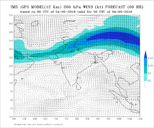
The 200 hpa Jet streams over the subcontinent is the additional parameter to be watched from MW-3 .

The jet streams are to be followed as the westerly jet core shifts to the north and easterly jet stream is formed, over the course of late summer, progressively from south to north of the subcontinent , heralding the progress of south-west monsoon over the subcontinent.

Currently are weak south-easterly, south of 8 N latitude.
They are required to strengthen to easterlies at those latitudes in the coming days, for heralding the SWM to the South Andaman Sea.


During April,  Sub Tropical Westerly Jet (STWJ): The highest wind speed of 96 kts was recorded over Dibrugarh.

The westerly jet core shifts north of the Himalayas during the southwest monsoon season, as the jet streams turn easterly over the subcontinent.


So, overall, we can summarize as:
PARAMETER
MW-1
MW-2
MW-3 
1) Cross Eq.Winds
Normal
-ve
-ve
2) Seasonal Low
+ve
-ve
-ve
3) ENSO
-ve
El Nino
El-Nino
4) Bay Low
-ve
-ve
-ve
5) ITCZ
Normal
Normal
Normal
6) Jet Streams
-
-
Normal
Overall
Slightly -ve
-ve
-ve


*But, situations can change fast, and by the time we discuss the next  MW, some factors can suddenly become +ve or -ve. So, MW discusses and follows the developments as they emerge, and discuss the parameters as is where are.


Looking at the current parameters, there seems slight delay in the South West Monsoon arrival dates for Andaman and Kerala as of now. 


South Andamans: 19th May
Andamans Islands : 22nd May

Maldives:  26th/27th May 
Sri Lanka: 30th/31st May

Kerala &NE States: 2nd/4th June.

Coastal Karnatak: 7th June

Goa 8th/9th June

Mumbai  & West Bengal: 12th/14th June.


Monsoon Watch should not be used/depended upon commercially or otherwise. Monsoon Watch Series may differ from other models.

 4th November Evening..Mumbai AQI