Co Authors: GSB, Shreyas Dhavale, Pradeep John, Dr. Vineet Singh, Gokul
Sunday, July 31, 2022
The popular Monsoon Analysis by GSB will be put up here at 11.30 pm IST
India recorded 327.7mm rain in july which is 16.9% above normal. In terms of actual rain this is the wettest July after 2005, in terms of percentage departure from normal this is the highest positive percentage departure from normal after 1994
Compiled by vag.Vineet
Seasonal Rainfall
Mawsynram 6238 mms
Cherrapunjee 6233 mms
Goa July Rains
Friday, July 29, 2022
Weekend forecast till Sunday 31st July:
Monsoon active over northern regions of India, chance of patchy thundershowers in Maharashtra!
Mumbai: Next few days, relief for commuters as Mumbai continues to get only passing showers. Warm and humid daytime, with a shower or two likely for this weekend.
मुंबई: पुढचे काही दिवस पाऊस कमी असेल. दिवसातून १-२ पावसाच्या सरी पडू शकतील, व दिवसा बराच वेळ सूर्यप्रकाश असेल. दिवसा थोडा उकाडा देखील जाणवेल.
Pune: Warm and humid daytime. Chance of rain/Thundershowers in parts of the district during afternoon/evening today and tomorrow. Isolated areas can get localized heavy rain.
Aurangabad: Warm days...some chance of light rain/thundershowers in parts of the district, not evenly distributed.
औरंगाबाद जिल्हा: दिवसा वातावरण थोडे गरम राहील. आज व उद्या काही भागात हलका पाऊस/गडगडाटी पाऊस पडू शकेल. पावसाचे प्रमाण सर्व ठिकाणी समान नसेल.
Madhya Maharashtra and Marathwada districts of Pune, Satara, Sangli, Kolhapur, Solapur, Ahmednagar, Nanded, Osmanabad, Beed, Parbhani could get patchy rain/Thundershowers today and tomorrow. Chance of rain decreasing from Sunday.
Himalayan regions of Jammu, Kashmir, Ladakh, Himachal Pradesh and Uttarakhand likely to get moderate rain with heavy in some regions for next 2 days. Avoid travel unless necessary.
Monsoon trough over northern plains, closer to Himalayas.
Wednesday, July 27, 2022
New Development in Meteorology: Now Categorizing and naming Heat Waves
‘Zoe’ Becomes the World’s First Named Heat Wave
Blistering temperatures ranked as a Category 3—the most severe tier—in Seville, Spain’s new heat wave system
The world’s first named heat wave hit Seville, Spain, this week, pushing temperatures past 110 degrees Fahrenheit and earning the most severe tier in the city’s new heat wave ranking system.
Heat wave “Zoe” has brought scorching temperatures to the southern part of the country for the last few days, particularly the region of Andalusia where Seville is located. Even in the evenings, the Spanish meteorological service recorded temperatures that hovered in the mid-80s in some areas — an extra stress on the human body, which relies on cooler nights to recover from high daytime heat.
Zoe is the first named heat wave to hit Seville since it officially launched a new pilot program last month for naming and ranking heat waves, similar to hurricanes (Climatewire, June 22). Only the most severe heat waves get names, designated this year in reverse alphabetical order. After Zoe, comes Yago, Xenia, Wenceslao and Vega.
The program is a collaboration between the city of Seville and the Atlantic Council’s Adrienne Arsht-Rockefeller Foundation Resilience Center (Arsht-Rock), with other partners including the Spanish Office for Climate Change and several Spanish universities and research institutes. It takes a three-tiered approach to categorizing heat waves in Seville, with Category 1 as the lowest ranking and Category 3 as the most severe.
The system has specific criteria for each category, involving not only daytime temperatures, but also nighttime lows, humidity and the heat’s expected effects on human health.
Each tier triggers a set of emergency response services, like issuing weather alerts, opening cooling centers and dispatching community health teams to check on vulnerable populations.
Spain has been grappling with extreme temperatures for much of the summer already. High heat broke local records around the country last month, and the first two weeks of June were the hottest on record in the country, according to the Spanish meteorological service.
Outlook for the next 4 days from Monday 25th - 28th July:
It's all about the shifting of the Monsoon trough..from extreme North, 8 days ago bringing rainfall in the Northern States to shifting South bringing rainfall to Rajasthan, Gujarat & Sindh last weekend. Now, from Tuesday 26th, a gradual Northern movement commences...from Wednesday 27th, gradually decreasing rains in Maharashtra, Gujarat, M.P. &Rajasthan....while increased rainfall in Delhi , Haryana. West U.P. and Uttarakhand and H.P.
Delhi : 25th/26th not much change...
Wednesday Rainfall increases from 27th...Temperatures dropping tp 30/31°
Mumbai: Passing showers on Monday &Tuesday.
Wednesday: 27th..Decrease in rainfall with sunny intervals. Around 31°
Pune: Pleasant week with light drizzles. Upto 5 to 7 mms rain/day. Around 28-29C.
Aurangabad &Marathwada: Monday 25th &Tuesday 26th, With few Passing showers, the crops will remain well watered.
Wednesday onwards decreasing rains. Maybe sunny.
Gujarat Region & Bharuch: Monday 25th &Tuesday 26th, Gujarat region will get fairly good rainfall.
Wednesday 27th onwards a sharp decreasing trend in rain and temperatures rising.
Sindh &,Balochistan received good rains. Rains can persist to a lesser extent in Sindh (Karachi) next 2 days. May reduce after that.
Rainfall of Rajasthan as on Sunday Morning
Rains in Gujarat last 24 hrs ended 24th Morning 👇
Saturday, July 23, 2022
Continuing , now the scene goes to Kutch and a Sindh
Rapar Kutch, 92 mms on Saturday evening ..6pm to 8pm. ...👇
Video courtesy Vag Gaurav Raninga ( Junagadh)
Bachau Kutch 52 mms...6 to 8 Saturday
And Sunday Jodhpur as told..Sunday afternoon 👇
23rd..July
Rains in Rajasthan last 24hrs
Kota 109 mms
Baean 60
Jaipur 89 mms
Bundi &Ramganj 55 mms
Jhalawar 55 mms
Churu 33 mms
Jaipur water-logging
Friday, July 22, 2022
22nd July....
The Monsoon Axis in normal position now, rains expected in Rajasthan on 22nd and 23rd..Good rains Jaipur expected.
But, increased rains expected in West Rajasthan (Jodhpur 40 mms or more) on Sunday 24th.
24th, axis moves South and creates an embedded low around Sindh.
Heavy rain expected in Kutch and moderate to heavy in Saurashtra on Sunday 24th & 25th Monday.
Heavy rainfall expected in Sindh. Including Karachi. Karachi can expect rains exceeding 100 mms cumulative on Sunday & Monday(As of now).
Mumbai sees a moderate increase in 🌧 rainfall on Saturday (evening) and Sunday 24th.
Pune too will see more frequent rain 🌧 on Sunday 24th.
With westerlies weakening, Thundershowers likely to continue for Bangalore and south interior Karnataka as well as Tamil Nadu
Wednesday, July 20, 2022
MMR Seasonal Rainfall till 20-7-22 in mms
Colaba 1218
CSMT 1427
Scz 1466
Dadar ( vag salil) 1638
Borivali 1554
Mira Bhayandar 1420
Vasai 1500
Virar 1770
Palghar 2172
Thane 1654
Airoli 1634
Rabale 1430
Turbhe 1857
Belapur 1401
Nerul 1527
Bhiwandi 1535
Kalyan 1743
Ulhasnagar 1643
Badlapur 1991
Neral 2105
Karjat 2056
Khalapur 1955
Panvel 1682
Pen 1848
Uran 1379
Alibaug 1270
Compilation by Vag. Abhijit Modak.
5 pm Image showing active Axis..and developing Break Monsoon
Weather forecast till Friday 22nd July -
Monsoon will be weak over the west coast.
There is no threat of any cyclone for both the west and east coasts of India.
Mumbai: Occasional light to moderate showers, with some sunshine intervals. No alerts.
Pune: Light showers/drizzles with sunny periods in the day. Pleasant weather, with max around 28-29C, rising slightly towards the end of the week.
Goa: Passing showers, mainly light to moderate intensity. Some sunny periods in the day.
No meaningful rains for Gujarat region, light showers in some parts of coastal Gujarat and Saurashtra.
Bharuch: Few showers amounting to 5 to 7 mms per day.
Rains increasing in Northern and Hill States
Monsoon trough likely to shift towards northern plains. Rain/thundershowers are likely across Punjab, Haryana, Delhi NCR, Uttar Pradesh and Bihar. Localized heavy rain is also possible. Uttar Pradesh and Bihar could see revival of monsoon, helping in covering up the deficit in some districts.
Uttarakhand, Himachal Pradesh and Jammu region could see moderate rain with heavy showers in some parts. There is a risk of localized flash floods and landslides/mud slides. Avoid travel unless necessary.
.
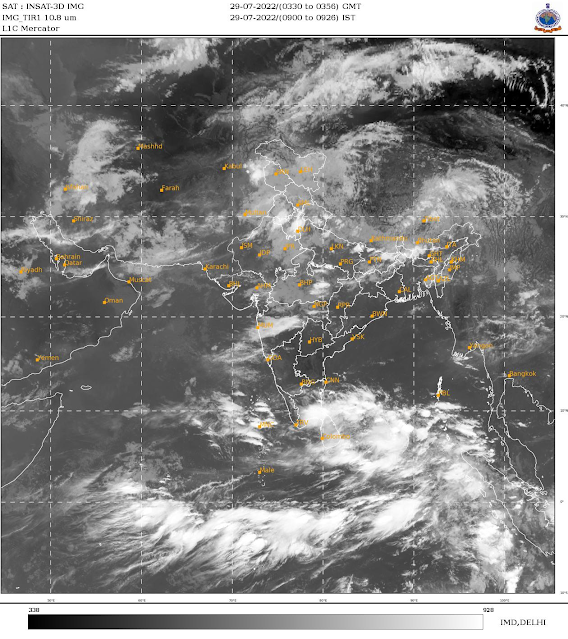
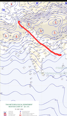
Tuesday, July 19, 2022
Monday, July 18, 2022
Posted Monday 18th Morning
Mumbai: After a pause of a few days, "Mumbai rains likely to show some increase on Monday 18th and Tuesday 19th.
Pune: The cool Climate with light rains will continue into Monday and Tuesday. Days pleasant around 26c.
"Aurangabad may see enhanced rain next 2 days. Will help local small Dams water Storage "
In Marathi...
औरंगाबाद जिल्ह्यात पुढचे १-२ दिवस चांगला पाऊस अपेक्षित आहे. जिल्ह्यातील धरणांच्या पाणीसाठ्यात काही प्रमाणात वाढ होऊ शकते.
AS-2 which became a depression over the northern Arabian Sea, is weakened as it tracks towards Oman.
Another low BB-7 moving in westward from Odisha will cause moderate to heavy rain across parts of Madhya Pradesh, Vidarbha region of Maharashtra and some parts of Marathwada (Aurangabad, Jalna).
Eastern parts of Gujarat (Bharuch/Vadodara/Godhra) and south Rajasthan could see some moderate rain/Thundershowers. Ahmedabad region could get some rain.
By Vagarian Shreyas
Sunday, July 17, 2022
27th July...
A heat wave was expected to hit Britain early this next week, when temperatures were forecast to reach 40 degrees Celsius (104 degrees Fahrenheit) for the first time.
Friday, July 15, 2022
15th July:
Today Vagaries celebrates 16 years of sharing Weather knowledge...that is celebrating its growing fondness with friends. It had been my aim 16 years ago, to create a suitable platform and interaction forum for the hitherto dis-organised Weather Lovers. I feel I have achieved this!
Vagaries has become a good platform for Weather Enthusiasts and brought together Weather amateurs from all over the world, and has become a good source of information sharing.
Vagaries is 16 years Old....16 Years of Weather Analysis, Weather Reporting, Weather Interaction and of course, Weather Forecasting.
There may have been certain drawbacks, but I do appreciate the support and encouragement I receive from my Vagaraians/readers. Believe me, it is your trust, comments and feedback that has kept me going.
Today, we are ranked 34th in the world amongst Weather Blogs and 2nd in India Weather Blogs! I personally convey my sincere gratitude and thanks for all the good wishes and support from all Vagarians and readers.
Bharuch: Light rainfall, not exceeding 10-20 mms/day. No major disruptions.
Low Pressure expected off Saurashtra Coast (Western Side);
Kathiawar/ Kutch: 16th/17th: Pocket pop ups of heavy rains expected in many regions..some isolated falls could be very heavy.
Gujarat 24 hrs Rainfall as on 14th July
14th July: Mumbai Lakes Storage
Last Modified: 14-Jul-2022 10:16 AM
65.81%
Combined live storage across all lakes compared to 17.35% same time last year. 952,550 million litres - Live storage as at 6 am 14 Jul 2022. [Annual requirement: 1,447,363 million litres, Total capacity: 1,778,000 million litres]
247
Number of days of supply left in all lakes combined (@ 3,850 million litres BMC supplies to city each day as against a need of 4,200 million litres).
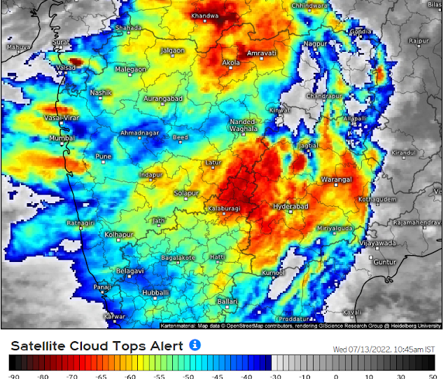
Wednesday, July 13, 2022
Monday, July 11, 2022
12th July...
Kutch covering annual rains soon...desert bonanza
Mumbai Live Storage spurts to 50%..6 Months Stock !
Posted 11th afternoon...BB-6 could induce a mid level vortex/MTC near North Maharashtra/south Gujarat region, which could result in the heavy rain event
Rains could increase further along North Konkan, northern western Ghats and south Gujarat from tonight for 2-3 days.
Mumbai: From 11th Monday Night, frequent showers of Heavy rain expected for Mumbai region. Strong winds on Wednesday. Exceeding100 mms/ Day
Mumbai Lakes at 40% Storage ......👉
Pune: Next from Monday night, for 2 days, Parts of Pune could also see moderate to heavy...Exceeding 25-30 mms/day.
Possibility of very heavy rains over parts of Thane, Palghar, Nashik districts on 11 and 12 July. Jalgaon ( Tuesday heavy..about 60-70 mms) , Dhule and Nandurbar districts of Maharashtra may see moderate to heavy rain.
Weather likely to be very windy over northern western Ghats, mainly from Mahabaleshwar to Trimbakeshwar stretch. Visibility could be low due to clouds and heavy to very heavy rains. Avoid travel in these areas.
Places in Gujarat from Navsari to Surat as well as Vadodara region could see heavy rain during this period.
Bharuch...Heavy rains next 2 days...Exceeding 60 mms/day
Surat: Heavy showers next 2 days...Exceeding 60-75 mms/day.
Valsad: Heavy rains Monday/Tuesday..exceeding 90-100 mms/day.
Bodeli, the district has seen over 530 mms in last 24hrs..will see a decrease in rain intensity.
Amarnath Tragedy: What exactly happened? FAQs below:
Q. What is a Cloudburst?
-- A Cloudburst is an extreme amount of precipitation in a short interval of time.
Q. When can we say that there is a Cloudburst?
-- As per the official agency IMD's criterion, only if there occurs rainfall with a fall rate of greater than or equal to 100mm in one hour, then it is termed as Cloudburst
Q. Was there a Cloudburst in Amarnath?
-- No, it was not! Amarnath Holy Cave station had recorded only 30mms of rainfall till 5:30pm when the actual tragedy took place. There was a mudslide from the valley behind where the rain could have been a bit more (A highly localised rainfall activity) which then caused flash flooding around the Amarnath Cave's vicinity.
Friday, July 08, 2022
Specified City Forecasts for Saturday 9th/Sunday 10th.
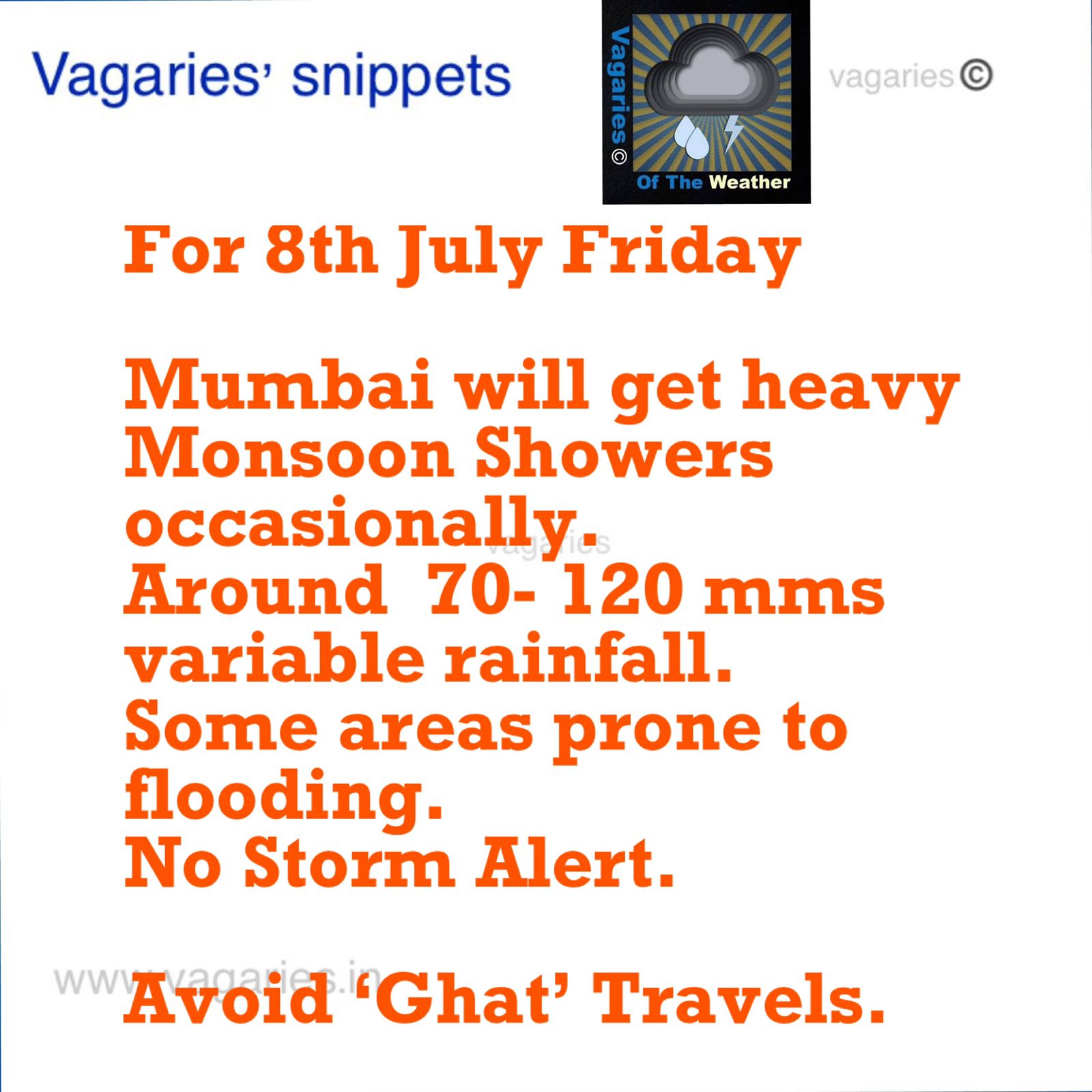
Mumbai : Saturday &Sunday :Cloudy with intermittent rains.Heavy prolonged showers on Saturday afternoon. Exceeding 40 to 50 mms/day. No .Alerts.
Pune:Light rains on Saturday with cool weather @25c. Lesser frequency on Sunday.
Aurangabad: Few moderate showers on Saturday..about 15 mms. Lessening on Sunday.
Bharuch: Frequent medium to heavy showers. Cool days. Increase next week.
Rajkot: Moderate intermittent rains.
Goa: Frequent moderate to heavy rains. Exceeding 50 mms /Day.
Delhi: Yes, starting Saturday, some cooling showers on Sunday.
See heavy rains figures of Gujarat 👉
Thursday, July 07, 2022
Wednesday, July 06, 2022
The Mumbai lakes and dams level reported at 6 am on 07th July 2022 is 276129 ML (19%) of the total 1447363 ML.
Last year on 07th July 2021 was 266848 ML (18 %) of the total 1447363 ML.
Mumbai receives freshwater supplies from various lakes and dams such as Upper Vaitarna, Modak Sagar, Tansa, Middle Vaitarna, Bhatsa, Vihar and Tulsi.
6th July Night
Mumbai:*As explained, after a day of reduced rainfall on Wednesday 6th, Mumbai,/,Thane and surroundings will now get more showers on Thursday 7th. No flooding.
*Much heavier rainfall on the weekend 8th/9th/10th. Certain areas water logging possible on weekend.
*Mumbai lakes increased to 16% ( last year 18%).
Pune: Rainfall showing good increase this weekend from Friday.
But still Gujarat Region deficit..Saurashtra improves
Gujarat:
Rain would increase in the coastal belt from Valsad till Surat with heavy rain possible on Friday-Saturday.
Saurashtra and Kutch would get moderate rain/Thundershowers over next 3 days. Intensity could be higher in Saurashtra on Friday 8th and Saturday 9th July.
Bharuch, Ahmedabad and Vadodara regions have chance of light to moderate rain on Thursday 7th and Friday 8th July.
ગુજરાત:

વલસાડથી સુરત સુધી દરિયાકાંઠાના પટ્ટામાં વરસાદ વધશે અને શુક્રવાર-શનિવારે ભારે વરસાદની શક્યતા છે.

આગામી 3 દિવસમાં સૌરાષ્ટ્ર અને કચ્છમાં મધ્યમ વરસાદ/ ગાજવીજ સાથે વરસાદ પડશે. શુક્રવાર 8મી અને શનિવાર 9મી જુલાઈએ સૌરાષ્ટ્રમાં તેની તીવ્રતા વધુ હોઈ શકે છે.

ભરૂચ, અમદાવાદ અને વડોદરા પ્રદેશોમાં ગુરુવાર 7મી અને શુક્રવાર 8મી જુલાઈએ હળવાથી મધ્યમ વરસાદની શક્યતા છે.
-‐--------------------------
Also, as discussed yesterday
Another low pressure area BB-6 is likely to form by 8th July and track westward.
With BB-6 pulling in stronger westerlies from Arabian Sea, moderate rain/Thundershowers are likely over entire Madhya Pradesh, parts of Telangana as well as Vidarbha and Marathwada regions of Maharashtra.
8th onwards Aurangabad, Jalna, Akola, Amravati, Buldhana, Jalgaon, Dhule, Nandurbar districts would see good rain, with heavy showers in some parts.
8 तारखेपासून औरंगाबाद, जालना, अकोला, अमरावती, बुलढाणा, जळगाव, धुळे, नंदुरबार जिल्ह्यांत चांगला पाऊस होईल, काही भागांत जोरदार सरी पडतील.
Inputs from Vagarian Shreyas
Tuesday, July 05, 2022
Post of 5th July Evening:
* Mumbai : On Wednesday 6th Mumbai (MMR)will see a brief day's let up with decrease in Rains (30-60 mms) as compared to last 24 hrs rain (100-150 mms) .. More rains again from Thursday/ Friday.
* Mumbai recorded 30-60 mms rain in daytime Tuesday (9 hrs.)
* Mumbai Lakes at 15% Storage (5th July).
*Pune: Light rains on Wednesday and cool day at 27c. More rains on Thursday.
* Goa will see heavy rains for the remaining part of this week.
* BB-5 has moved thru Central India and is pushing into Gujarat, with heavy rains on 6th..Later into South Pakistan Coast.
* Another Low, BB-6, will form in the Bay later this week (8th)...and will move West from Odisha Coast. BB-7 will show up as the 3rd Low in this series next week...tracking thru Central India (it seems).
* All India Monsoon deficit at -3% now...Should be in positive range soon.
5th July
Next 24-36 hours: Moderate to heavy rain expected in parts of Vidarbha (Amravati, Akola) and north Madhya Maharastra (Jalgaon, Dhule, Nandurbar districts). Marathwada to get light to moderate rain. Some parts around Aurangabad and Jalgaon can receive localized heavy rain.
Coastal Gujarat (Surat-Valsad) can see moderate to heavy rain today.
Ahmedabad/Gandhinagar and Vadodara could see moderate rain/Thundershowers today and tomorrow.
Saurashtra and Kutch regions also likely to see light to moderate rain/Thundershowers, with localized heavy rain.
Next 24-36 hours: Very heavy to extremely heavy rains with possibility of flooding in Ratnagiri, Sindhudurg districts of Maharashtra as well as Goa.
Monday, July 04, 2022
Panji Goa 208 mms till 8.30
Mumbai Scruz 63 mms till 11.30pm
Mumbai: Increase in Rainfall in Mumbai Region and very heavy in Konkan Goa. Very heavy rains expected Monday 4th evening and on Tuesday 5th Mumbai may cross 100 mms from Monday Evening - Tuesday evening. Potential flooding in some regions.
Lakes levels will improve.
Saturday, July 02, 2022
2nd July MumbaiWater Storage:
10.90%
Combined live storage across all lakes compared to 18.28% same time last year.
41
Number of days of supply left in all lakes combined.
Sunday Mumbai will get some rain relief with lesser rain showers and periods of sunshine.


.png)


.png)
.png)


.png)


