Monday, August 31, 2015

August Rains Update: Rohit's Page Updated with All India Rains (Capitals), Mumbai Page with Panvel, Badlapur and Borivali Private rain readings by Vagarians, and Vagaries Goa Updtaed ..All Superbly depicted !

MONSOON REPORT (01-6-2015 TO 31-8-2015)
TOTAL ALL INDIA RAINFALL (as on 31-8-2015) 632.2 mm
SEASON +/- -11%
RAINFALL IN AUGUST 2015 202.4 mm
AVERAGE AUGUST RAINFALL 262 mm
DIFF +/-  -59.6 mm
TO ACHIEVE BY 30TH SEPTEMBER          required per day------->    mm
MINIMUM                             700   mm 2.26
AVERAGE                                890   mm 8.59
MAXIMUM                          1100   mm 15.59
CURRENT RAINFALL PER DAY  6.87 mm
REQUIRED PER DAY TO ACHIEVE SEP AVERAGE (174 mm) 5.8 mm
TOP FIVE SUBDIVISIONS THIS MONTH mm
SHWB & SIKKIM 626.6
ASSAM & MEGHALAYA 618.4
ARUNACHAL PRADESH 596.5
COASTAL KARNATAKA 521.2
A & N ISLAND 480
BOTTOM FIVE SUBDIVISIONS THIS MONTH          mm
N. I. KARNATAKA 78.4
WEST RAJASTHAN 60.5
MADHYA MAHARASHTRA 55.9
GUJARAT REGION 40.7
SAURASHTRA & KUTCH 13.6
TOP FIVE SUBDIVISIONS ABOVE NORMAL (1-6-2015 to 31-8-2015) %
WEST RAJASTHAN 57%
GANGETIC WEST BENGAL 25%
WEST MADHYA PRADESH 22%
COASTAL ANDHRA PRADESH 12%
ARUNACHAL PRADESH 12%
BOTTOM FIVE SUBDIVISIONS BELOW NORMAL (1-6-2015 to 31-8-2015) %
WEST U.P. -33%
EAST U.P. -36%
MADHYA MAHARASHTRA -40%
N. I. KARNATAKA -43%
MARATHWADA -50%
TOTAL ABOVE AVERAGE DAYS (1-6-2015 to 31-8-2015)    31 (34%)
TOTAL BELOW AVERAGE DAYS (1-6-2015 to 31-8-2015)    61 (66%)
TOTAL ABOVE AVERAGE DAYS IN AUGUST      7 (23%)
TOTAL BELOW AVERAGE DAYS IN AUGUST      24 (77%)
source -IMD

Saturday, August 29, 2015

South West Monsoon Withdrawal Parameters: And Scenario as on 29th August

Considering the reasons below, and if the situation continues this way, we may see the South West Monsoon withdrawing from Pakistan, West Rajasthan and Southern Parts of adjoining Punjab (to begin with) around 3rd/4th September.

Explanation:
South West Monsoon Criteria for Withdrawal as per IMD:
Withdrawal of SW Monsoon

a) Withdrawal from extreme north-western parts of the country is not attempted before 1st September.

b) After 1st  September:

The following major synoptic features are considered for the first withdrawal from the western parts of NW India.
i)        Cessation of rainfall activity over the area for continuous 5 days.
ii)       Establishment of anticyclone in the lower troposphere (850 hPa and below)
iii)      Considerable reduction in moisture content as inferred from satellite water vapour imageries and tephigrams.

Position Scenario on 29th August:
Taking b)...we see the i) and iii) criteria already effective as on 29th August. 
Water Vapour Imagery on 29th August:


The anti cyclone in 850 hp level is not established today. But wee see a ridge forming around 1st week of September in the Pakistan/Rajasthan region. So, effectively, the anti cyclone gets into formation.Upper winds in North and Central India change directions.

Parameters for Withdrawal considered by Vagaries:

Another factor  is the 200 hp jet stream. This is one of the main and assertive parameter. The Easterly winds at 200 hp, gradually become Westerly starting from the Northern regions as the Monsoon withdrawal line moves South. In fact, these winds bring down the axis and the withdrawal line.
As the Monsoon withdrwal commences, the seasonal Low weakens, and the core (then becoming around 1000 mb during initial withdrawal ) moves to North Pakistan region.

Today, the West winds (at 200 level) are firmly above the 30N line, and gradually sliding South. An anticyclone High forms in the jet streams around the Sindh coast by 1st week of September, thereby creating Westerly winds almost throughout the region of Pakistan and Rajasthan.

-Another factor, connected is the Outgoing Longwave Radiation (OLR)
Today, OLR is also not conducive for the Monsoon to hold on much longer in Pakistan and Rajasthan.


-Also, the Upper Troposphere Humidity plays an important part in supporting and "holding " the Monsoon. The current humidity position indicates a weak situation for Monsoon sustenance.


Thursday, August 27, 2015


RARELY SEEN BEFORE...VAGARIES SHOWS VERY RARE GIGANTIC JETS ABOVE HURRICANE HILDA......SEE VIDEO ON VAGARIES  SPACE NEWS PAGE

Posted Thursday 27th Night:

Mumbai: Friday evening may see a few showers, with lightening from the Eastern skies.Around 10 mms expected on Friday. But the wait for meaningful substantial rains continue...Rains decreasing on Saturday and Sunday.
Eastern Outer townships and rest of Interior North Konkan ( Roha and adjacent regions included) can get Thunder showers by Friday evening. The spotty thunder showers may precipitate upto 15-20 mms in Konkan. Rainfall intensity decreasing by Saturday.


Amounts in cms 

As BB-5 tracks West, Heavy rains expected in Chattisgarh, Vidharbh , M.P. and parts of Marathwada on Friday and Saturday. We see rains clearing from Odisha soon and  Chattisgarh from Friday.
Saturday Heavy rains in M.P, Vidharbh, Marathwada and adjoining East Gujarat regions.
Sunday rains restricted to West M.P. .
BB-5 fizzles out in the M.P. region by Monday.

Kolkata: After a good rainy period, a short break till Sunday. Sunday thru Tuesday , this city sees another increasing rainy spell.

Hyderabad gets a fringe benefit of BB-5. Some showers on Friday, around 15 mms, and then decreasing from Saturday.

Delhi NCR: After a good August, the Capital region sees hot days ahead...Given the alert yesterday, the temperatures have inched up to 37c in Delhi on Thursday. With no rain expected, Can now expect the 38/39c mark easily in a day.

Pune: Light rains in some parts of city. Day may warm up to 31c by Sunday.

Temperature rising trend moving into North India..


South West Monsoon withdrawal Parameters:We will observe the Water Vapour content in Pakistan and Rajasthan next few days. The upper air situation and the behaviour of 200 hp jet streams to be observed for the next few days. Shall publish the review on Saturday 29th.

Monday, August 24, 2015

Posted Tuesday Night:

Mumbai got intermittent showers amounting to 9 mms (Vagaries) and 7 mms (Santa Cruz) till Tuesday night. However, the outer townships did better, with Thane receiving 66 mms, Panvel 79 mms (Junaid's measure), Badlapur 65 mms (Abhijit's gauge) and Navi Mumbai getting 44 mms till evening.
Mumbai and outer township Rains are likely to decrease from Wednesday.

In Pakistan, the heat continues to rise, with Nokkundi now touching 46c.

Odisha and parts of A.P. are likely to get heavy showers on Wednesday. Thursday, Heavy rains extend to Chattisgarh.

Kolkata may get a couple of showers. Not much direct effect of Bay Low. 

But, Delhi NCR may see increasing heat, with the day posiibly touching 38c soon.

Mumbai Lakes Levels and Water Position on Mumbai Page..

Posted Monday Night:

Probability: Conducive winds may allow an An upper air trough at 500 hp levels may temporarily form off and around Mumbai coast on Tuesday.This may bring some heavy showers in Mumbai, and may precipitate around 15-20 mms on Tuesday. Vortex may fizzle out in 24 hrs.

Mumbai rainfall in August this year is extremely low like July....So far Colaba 101 mms (Driest August was in 1943 with 83.3 mms)...and for Santa Cruz this year rainfall measured is 107 mms ( Driest August was in 1972 with 108.6 mms).
Total till Monday: Colaba 1248 mms and Santa Cruz 1572 mms.

Delhi NCR got regular showers on Saturday and Heavier in parts on Sunday. Ayanagar measured 111 mms, Palam 68 mms and S'Jung 56mms and Gurgaon 49 mm still Monday morning.
Kolkata too received the weekend showers. DumDum 47 mms and Alipore 2 mms !
As anticipated, rains decreased in Hyderabad from Sunday.

As expected , days have become hotter in Balochistan (Pakistan), with Nokkundi showing 45c and Dalbandin 44c...

A Low can form in the Bay off the Odisha Coast by 26th. 
Heavy rains likely in Odisha and Northern A.P. Wednesday 26th.

Seasonal Rainfall (in mm) from 1 June To 24 August 2015..on Current Weather Page...with Mah/Guj/M.P. Detailed Map..

Saturday, August 22, 2015

23rd August: Day's Highest;Mitribah (Kuwait) 49.3c and Kuwait AP 49.2c
23rd Minimum Temperatures in Oman: Khasab AP was 35c and Seeb AP (Muscat) today was 34.6c.

Balochistan and Sindh regions of Pakistan have started to heat up...with Sibi and Dalbadin recording 42c on Sunday...Possibly rising more next few days.

A Low Pressure Likely to form in Bay off Odisha Coast by 26th August.


Vagaries will publish next week's weather scenario and forecast and on Monday 24th...
Vagaries' September outlook will be published before end of this Month.

--------------------------------------------------------------------------------

Hottest Place in the World on 22nd is Mitribah Kuwait recording 50.6c. Basra A.P.(Iraq) recording 50.4c. 

On 21st, Mitribah Kuwait was 51.8c and Basra A.P. was 50.2c.

Sohar Majis , Oman...21st August..Max Temperature 49.8c..Min 30.3c and Dew Point 29.5c. 
Works out to Heat Index of 73c !!
(Thanks Max for Information)

Friday, August 21, 2015

Vagaries had made a 15 days ( approx) forecast till 20th August on 7th August. Let us analyse and see how it has worked out:

Forecast published on 7th


Actual accumulated Precipitation last 15 days till 21st August. The deeper colours indicate heavier rains..absolute rains totalling below 100 mms accumulated not indicated. (Map from NRL )


And by the way Friday Rains: , Arpit mentions Showers in many areas of NCR on Friday..S'jung 6 mms and Palam 7 mms and Noida 33 mms till evening. Vagarian Sukhwinder also reports of goood rains from Ferozepur (Punjab)...and showers in Bangalore writes R.Kumar from there.

Thursday, August 20, 2015

Posted Friday 20th Night:

The Monsoon axis remains in the foothills of the Himalyas. The rains will be mainly restricted to the Kashmir-H.P.-Uttarakhand and the U.P. region next few days. Rains will be heavy in the region of Nepal and Sikkim, besides Assam and Meghalaya. 

Flood potential for Himalayan West Bengal, Sikkim and North Bangladesh seems high.

A W.D. will interact with the axis from Thursday Night thru Saturday. This will bring heavy showers in Northern Pakistan Punjab and Kashmir. Moderate rains with heavy falls in some places in Indian Punjab. Haryana  and West U.P.
Some marginal /nominal increase in showers in South Konkan and Coastal Karnataka this weekend.


As the East coast trough formulates, a Low may form off the Odisha Coast by Wednesday 26th.

Mumbai this Friday/Saturday and Sunday will be partly cloudy with sunny periods. A few showers on Friday, around 5 -10 mms. Slight increase in rains on Saturday with some showers with thunder, amounting to around 10-15 mms. Sunday will be cloudy with a couple of showers with thunder.
Pune: No meaning full increase seen in Pune this weekend. The usual light drizzles in some parts, with the gauge just managing a few mms.

Kolkata sees the routine getting more regular and will get showers or thunder showers this weekend. The daily rain will be regular and around 20 mm/day.

Delhi NCR: A thundery and showery Saturday and Sunday. Some heavy spells expected in some parts of the NCR.

Chennai: The good rains resume here after a nice July...Likely to see Thunder showers on Friday, Saturday and Sunday. Some with gusty winds. Daily average may measure around 15-20 mms.
Hyderabad: After rains the last 2 days, Hyderabad will get another shower on Friday as well. But, possible decrease on Saturday and Sunday.
Bangalore too can expect a shower or two on Friday. Saturday may see some heavy showers in many parts of the city.

Wednesday, August 19, 2015

Last 5 days Rainfall amounts of the 2 Kings...Mawsynram and Cherrapunji:

19th August: Mawsynram  745 mms  Cherra 472 mms            

18th Maw    526 mms      Cherra    313 mms
17th  Maw   198 mms      Cherra   162 mms  
16th  Maw   409 mms      Cherra   195 mms
15th  Maw   N.A.             Cherra    191

Seasonal Total from 1st June - 19th August 2015:

Cherrapunji = 7263 mms (+818):     (From 1st January: 9010 mms)       
Mawsynram (1st June-19th Aug) = 8380  mms      

Western Ghats (1 Jun - 19 Aug 2015) : 

Hullikal       4604 mms
Mastikatte  4460 mms
Agumbe     4262 mms 
Talacauvery (Kar) ..4207 mms (till 17 Aug 2015)
Lamaj (Maha) ..      3997 mms 
Shirgaon (Maha) .. 3931 mms 
Mulshi (Maha) ..     3701 mms 
Mahableshwar       3155 (-1263)

(Thanks Rohit and Pradeep for your inputs of Mah and Kar. Table below compiled by Rohit).


Monday, August 17, 2015

Indian Mars Orbiter Shoots Spectacular New Images of Sheer Canyon and Curiosity’s Crater...See Spectacular Pics from MOM on Space News Page


Mumbai Lakes Storage as on 17th August is at total of  921 Mcum, combined of all Lakes. That is 64% full...250 days stock available  i.e upto 25th April

Mumbai:18th/19th and 20th (next 3 days)  will be hot and mostly sunny days, with little rain.

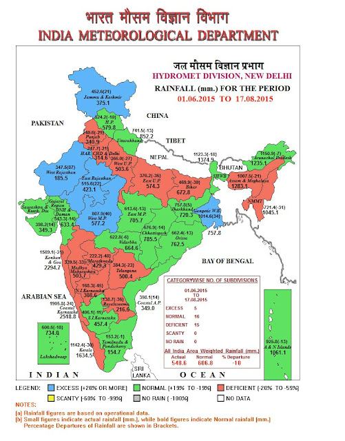
Seasonal Rainfall (in mm) from 1 June To 17 August 2015
Region                               Actual                Normal          % Departure
All India                              548.6                 606.8                 -10

East & Northeast India        864.6                 987.0                 -12
Northwest India                  420.0                 417.5                   0
Central India                       611.2                 671.7                  -9            
South Peninsula                 386.5                 483.1                 -20

Maharashtra, M.P. and Gujarat: Till 17th August:


Marathwada region is deficient by -48%. Three districts (Latur, Parbhani and Beed) are seen as scanty 
Overall Maharashtra is also deficient by -27%.

Overall Dams and reservoirs in Marathwada are only 9% full as on 17th August...As Many as 5 reservoirs are at 0% level.
MARATHWADA REGION Dams and their storage level % as full:

Jayakwadi A'Bad...  5% 
 Purna Yeldari Parbhani ... 3% 
 Purna Sddheshwar Parbhani....  0%
 Majalgaon Beed....  0% 
 Manjra Beed ... 0% 
 Upper Penganga Nanded .... 23% 
 Lower Terna Osmanabad ... 0% 
 Manar Nanded ... 3% 
 Vishnupuri Nanded ..... 11% 
 Lower Dudhna Parbhani..... 25% 
 Sina Kolegaon Osmanabad...  0% 

Southern India:2 Scanty districts adjoining to Marathwada in N.I.K.


Friday, August 14, 2015

See Saturday's Weather map on Current Weather Page

2014 Rains Saesonal Total for Comparison (From Rohit)
2015 Toppers till 14th August in Maharashtra/Karnataka...Prepared by Rohit Aroskar


Posted Friday Night:

Refer to the Map below...
1.Original Position of BB-4 on Thursday Night
2. Track actually taken by BB-4...varying more to the East ..differential track taken by BB-4.

3. Expected track of BB-4 as envisaged in Vagaries


Rains shifting to North-East/North...away from Konkan ?

Posted Thursday 13th Night:

After having flooded Vidharbh (see Nagpur pics below), BB-4 has moved West and lies weak over Central M.P. Will ascend to form a UAC over the M.P. region and will be embedded in Monsoon axis.


Mumbai sees some increase in rain Intensity on Friday 14th. Frequent showers with some very heavy. Average around 30-40 mms. Saturday will see occasional showers, again, some heavy.

Increase in rainfall also in Surat from Friday.

x-------------------------------------x-----------------------------------------x-----------------------------------x

Rajasthan Enjoying a Super Monsoon...

                                              Actual          Normal       Surplus
WEST RAJASTHAN 313.9    172.0        82%    

EAST RAJASTHAN         474.0    390.3       21%

x-----------------------------------x------------------------------------------x-------------------------------------x

Mumbai Water Supplying Lakes Storage ..see Mumbai Page

Nagpur Flooded with BB-4 rains on 13th August: Pics sent by Capt Potey and Akshay


Tuesday, August 11, 2015

Heavy showers lash Vidharbh & M.P....Nagpur records 74 mms in 24 hrs ended 8.30 am (Thursday) and another 49 mms in 3 hrs after that on Thursday. Overcast as on Thursday noon at 24c.

Chandrapur measured 67 mms, Brahmapuri 60 mms,Akola 25 mms as on Thursday morning.

In M.P, Ujjain records 45 mms and Jagadalppur ( South Chattisgarh) 47 mms.

----------------------------------------------------------------------------
Posted Wednesday Night:
Mumbai: Thursday will cloudy with periods of passing showers. Heavy parts of city. Around 15-20 mms of rain.

BB-4 is now as a Low positioned about 200 kms West of Bhubaneshwar. The Low will move Westwards on Thursday, and possibly, then track as a trough NW and merge in axis.The main convective region is the Southern and SW region of the Low region.
Heavy rains now likely on Thursday in Madhya Pradesh, South Chattisgarh, Vidharbha.
Hyderabad will be cloudy with a few showers.

BB-4 has a rough "conical" shaped low belt. It was off Odisha/North A.P. coast and has moved Westwards.  As a result, what we expected, several places in Telengana got heavy rains...amongst them( In mms)
MANTHANI            110.2 mms
KARIMNAGAR    108.0
RUDRUR(A)            104.0
KALESWARAM   102.0
KOTGIRI                    90.0
BEJJANKI            75.8
VARNI                    75.8
BIRKOOR            75.4
JUKKAL                   75.4
MAHESWARAM  74.4
ASIFABAD            72.6
BHUPALPALLE  71.6
MULUGU(ARG)  70.0

Several places in A.P. also recieved heavy rains. Vizag got 101 mms in 12 hrs ended 8.30 pm Wednesday.
Other places are:
PUSAPATIREGA                 115.2 mms
CHEEPURUPALLE                   97.8  mms
DENKADA                           88.4  mms
PEDDAPURAM                  85.0  mms
PEDDAPURAM(A)                   76.0  mms
GARIVIDI                                  74.2 mms


Seasonal Rainfall (in mm) from 1 June To 12 August 2015 
Region                                 Actual                                  Normal                                  % Departure  

All India                                 511.6                               562.3                                          -9% 
East & Northeast India         815.1                              925.7                                         -12% 
Northwest India                    390.6                               381.8                                         +2% 
Central India                        566.8                                619.5                                         -8% 
South Peninsula                    360.1                               451.9                                         -20%
--------------------------------------------------------------------------------------------------------------------

Posted Tuesday Night:

Low (BB-4) forms off the Odisha Coast...

Showers expected in Telengana and adjoining Marathwada on Tuesday Night and Wednesday...Hyderabad can get showers intermittently in the day. Heavy rain in around the vicinity expected.

Thunder showers continue in Delhi NCR on Wednesday. NCR will get around 20 -25 mms average on Wednesday.

Mumbai forecast was given till Wednesday...onwards estimate for weekend will be up tomorrow. 
Roha and vicinity  will continue to get the sporadic showers (around 20 mms) on Wednesday. Further estimate for Thursday (which can show more rains) will be put up on Thursday.


In M.P, Bhopal received 66 mms in 12 hrs ended 8.30 pm IST on Tuesday. In Vidharbh, Chandrapur and Wardha both measured 21 mms and Nagpur 17 mms in the same period.


Forecasted East rough  Let's look into the 3rd week of March ( 17th - 21st). Mumbai : Hot weather likely for Mumbai region this week, ty...