| RAINFALL REPORT 1-10-2019 to 31-12-2019 (in mm) | ||||
| ( Districts over 500 mm rainfall actual) | ||||
| DISTRICT | STATE/UT | ACTUAL | NORMAL | DEP+/- |
| NAGAPATTINAM | Tamil Nadu | 1062.3 | 932.2 | 14% |
| KARAIKAL | Puducherry | 1053.6 | 1032.5 | 2% |
| LAKSHADWEEP | Lakshadweep | 874.3 | 321.8 | 172% |
| ERNAKULAM | Kerala | 807.8 | 519.9 | 55% |
| NILGIRI | Tamil Nadu | 783.1 | 477.2 | 64% |
| RAMANATHAPURAM | Tamil Nadu | 763.2 | 523.1 | 46% |
| KOTTYAM | Kerala | 761.3 | 535.1 | 42% |
| PATTANAMITTIA | Kerala | 749.4 | 603.2 | 24% |
| MAHE | Puducherry | 730.8 | 397.8 | 84% |
| ALAPPUZHA | Kerala | 721.6 | 587.9 | 23% |
| CUDDALORE | Tamil Nadu | 694.4 | 704.6 | -1% |
| KOZIKOD | Kerala | 694.3 | 450.1 | 54% |
| KANCHIPURAM | Tamil Nadu | 688.4 | 689.3 | 0% |
| UDUPI | Karnataka | 688.2 | 272.8 | 152% |
| THIRUVARUR | Tamil Nadu | 686.2 | 742.1 | -8% |
| TIRUNELVELI | Tamil Nadu | 684.1 | 473.0 | 45% |
| MALAPPURAM | Karnataka | 669.4 | 478.9 | 40% |
| PUDUCHERY | Puducherry | 663.9 | 882.0 | -25% |
| TRISHUR | Kerala | 655.5 | 514.3 | 27% |
| CHENNAI | Tamil Nadu | 631.7 | 761.6 | -17% |
| KASARGOD | Kerala | 622.5 | 344.4 | 81% |
| DAKSHIN KANNADA | Karnataka | 619.4 | 369.5 | 68% |
| KANNUR | Kerala | 612.3 | 375.6 | 63% |
| KOLLAM | Kerala | 609.0 | 630.8 | -3% |
| NELLORE | Andhra Pradesh | 590.8 | 667.4 | -11% |
| SOUTH GOA | Goa | 580.0 | 197.3 | 194% |
| TIRUVALLUR | Tamil Nadu | 573.6 | 629.7 | -9% |
| EASTMEDNIPUR | West Bengal | 570.4 | 211.6 | 170% |
| TUTICORIN | Tamil Nadu | 560.7 | 427.7 | 31% |
| NORTH GOA | Goa | 555.5 | 209.3 | 165% |
| THANJAVUR | Tamil Nadu | 549.0 | 593.7 | -8% |
| EAST KHASI HILLS | Meghalaya | 537.3 | 358.9 | 50% |
| JAINTIA HILLS | Meghalaya | 536.8 | 703.7 | -24% |
| THIRUVANANTHPURAM | Kerala | 533.8 | 550.8 | -3% |
| EAST GARO HILLS | Meghalaya | 529.4 | 199.9 | 165% |
| UTTAR KANNADA | Karnataka | 527.9 | 197.7 | 167% |
| KANYAKUMARI | Tamil Nadu | 527.8 | 523.9 | 1% |
| ARIYALUR | Tamil Nadu | 523.5 | 578.3 | -9% |
| PUDUKKOTTAI | Tamil Nadu | 521.1 | 410.5 | 27% |
| NICOBAR | A&N Island | 514.2 | 881.5 | -42% |
| IDUKKI | Kerala | 513.5 | 567.7 | -10% |
| SOURCE | IMD |
Tuesday, December 31, 2019
Saturday, December 28, 2019
See Vagaries Extreme Blog For " Prolonged North India Cold " Temperatures here
-------------------------------------------------------------
India winters .. 28 Dec 2019 noon
A detailed comparison with other parts of the world
1) North Indian plains are experiencing it's coldest winter of this century till now
How cold is North India ?
During the past 2 weeks ; temps in Delhi ,Haryana , Punjab have been close to London (England) / Tokyo (Japan) temperatures .So, North Indian plains are experiencing European / Japanese winters at present.
Comparison of temps during past 24 hours dated 28 Dec (morning)
(all temps in celcius , max/min)
A) North Indian plains were as cold as major European cities ,New York /Vegas valley / Sonoran desert (US) , Tokyo region (Japan) , Sichuan Basin (China) .
Temps over the North Indian plains have been lower than normal by upto 12 c during day time and upto 8 c during night time
Delhi 13 / 2 , Jhansi 10 / 2 , Varanasi 13 / 5 , Amritsar 9 / 5
London 8 / 7 , Rome 14 / 3 , Paris 9 / 7 ,
Madrid 16 / 3 , Zurich 7 / 3
New York City 11 / 6 , Las Vegas 12 / 5 ,
Phoenix 11 / 8
Tokyo 14 / 4 ,
Chongqing (Sichuan Basin, China) 12 / 6
B) Some Rajasthan regions were as cold as Rio Grande region of Texas (US) ; during past 24 hours
Sikar 20 / -1 , El Paso 17 / 3
C) Himalayan states are experiencing their coldest winter in a decade .Srinagar was as cold as the Rocky mountain cities of US , Eastern China , South Korea ; during the past 24 hours
Srinagar 9 / -6
Denver (US) 2 / - 7
Beijing 5 / -7 , Wuhan 12 / -3
Seoul 3 / - 4
D) The High Altitude cold desert of Ladakh and Himachal is as cold as North China / Urumqi valley / Taklamakan desert / Gobi desert of China , southwest Siberia
Leh 0 / -20 , Dras -11 / -30 , Keylong -2 / -11
Harbin (North China) -16 / -31,
Urumqi (China) -11 / -16
Kashi (Takla Makan desert , China) 1 / -11
Hohhot (Gobi desert , China) -5 / -17
Novosibirsk (southwest Siberia ) -24 / -32
(The above Chinese and Siberian cities have population of 20 to 60 lakhs , whereas the cold desert of India is sparsely populated)
E) Kendujhar (Orissa) was as cold as Atlanta(Georgia,US) / Raleigh (North Carolina ,US) ; during past 24 hours
Kendujhar 17 / 5
Atlanta / Raleigh 17 / 6
F) Madhya Pradesh was bit cooler than Dallas (Texas , US) ; during past 24 hours
Bhopal 21 / 5 , Jabalpur 20 / 4
Dallas 21 / 8
G) Nagpur Airport(Eastern Maharashtra ) 25 / 5 was bit cooler than
Charleston (South Carolina,US) 24 / 9 ; during past 24 hours
H) Kolkata (Bengal) was as cool as Houston ( Texas ,US ) at 20 / 11
( Chinese cities are prone to extreme frigid cold waves from Siberian blast , US cities from Arctic blast.
North Indian plains are shielded by the Himalayas from such extreme freezing cold blasts)
2) Winter warmth (temps during past 24 hours ) max / min
Mumbai 32 / 20 , Goa 32 / 22 , Miami (US) 28 / 23
Pune was relatively mild at 27 / 18
3) Some images and old archive pics
a) North India fog today (the cause of lower than normal day temps)

b) Below, from Rajesh's Old Record Archives: Delhi record of Dec 1973 ( min temp 1.5 c )

Ladakh frigid cold of Dec 1994 (Dras -50 c)

Friday, December 27, 2019


Thursday, December 26, 2019
Fatehpur in Rajasthan records - 3 c Thursday


Delhi, Haryana and Punjab Experience Longest, Severest ‘Cold Day’ December Spell Since 1997
Delhi, Haryana and many Punjab Towns experienced its 10th straight day of intense ‘cold day’ conditions by 25th December, effectively making this the longest and severest ‘cold day’ December spell in the capital in the past 22 years.
The last time Delhi experienced a similar cold spell was back in December 2014, which also consisted of 8 successive ‘cold days’.
However, the conditions in the ongoing spell are not just harsher, but the spell is also set to last longer.
"Severe cold day" conditions were observed across the capital, with departures from normal maximum temperatures registered in Delhi’s districts of (8/9c departure),
Churu saw 1.3c and Mt Abu 1.0c on 26th Morning.
Leh -18c, Gulmarg -9c and Srinagar -5c.


Wednesday, December 25, 2019
Monday, December 23, 2019
Posted 23rd December evening


The low pressure in the South Arabian Sea exists and extends into the upper air.
The trough from the system towards the Konkan coast will form and subsequently the trough will extend from West to East along the 20N line.
Rains expected in Konkan, Madhya Maharashtra and Vidharbha from 25th Dec.
Christmas Rains expected
Temperatures were high in Goa today at 34c. Showers expected in Goa on 25th /26th.
Mumbai Scz was hot today at 34.6c...tomorrow will be warm and partly cloudy ⛅.. Light showers expected on 25th /26th.
Pune had light drizzle on Sunday 22nd night. On 25th /26th pune can expect showers. Rain reappearing on 29th and 30th December.
Aurangabad and Nagpur will also get showers starting from 25th to 30th.
Sunday, December 22, 2019
Sub 20 c temps at Mumbai Scz ( Vile Parle )..
The seasonal weather variations at Mumbai and Konkan / Goa are not so extreme .
Sub 20 c minimum temps mark the change of seasons in the tropical city of Mumbai ( similar on the lines of the first freeze 0 c , in temperate climates ) .
21st century AVERAGES for sub 20 c minimum temp at Mumbai Scz ( Vile Parle ) ..
Last sub 20 c (avg 19.3 c) min of the season :
21 March (avg)
First sub 20 c (avg 19.2 c) min of the season :
7 November (avg)
Avg. Time interval between last and first
sub 20 c min : 231 days
21st century RECORDS :
Shortest time intervals between last and first
sub 20 c min :
199 days (year 2005)
210 days (year 2011)
211 days (year 2015)
Longest time intervals :
275 days (year 2002)
265 days (year 2019)
255 days (year 2014)
Last sub 20 c min temp of the season :
Earliest : 26 Feb 2002 @ 19.5 c
Most late : 11 Apr 2005 @ 19.7 c
First sub 20 c min temp of the season :
Earliest : 19 Oct 2007 @ 18.7 c
Most Late : 13 Dec 2019 @ 19.5 c
Saturday, December 21, 2019

Thursday, December 19, 2019
Posted 19th morning :
A low pressure area is likely to form in the South West Arabian Sea on 22nd.
A trough from the system will possibly extend to the Maharashtra coast. Possibility of forming a "fulcrum low" in interiors of Madhya Maharashtra.
Good chances of moderate rains in Konkan and Madhya Maharashtra on 23rd and 24th December.
Mumbai : Good chances of rain showers on 23rd and 24th December.
Chances dim of winters getting cooler soon in Mumbai.
Pune : chance of rain showers on 23rd and 24th. Winter temperatures will rise from 20th.
Goa can get some showers on 22nd and 23rd.
Wednesday, December 18, 2019

Tuesday, December 17, 2019
Posted 17th December:
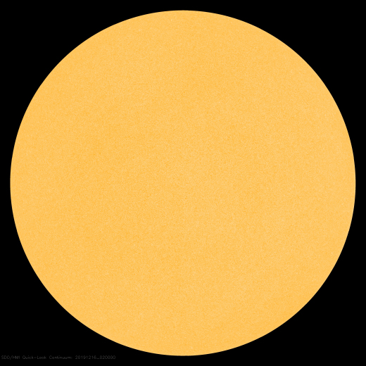
Above: The blank sun on Dec. 16, 2019. Credit: NASA/Solar Dynamics Observatory

SUNSPOTS BREAK A SPACE AGE RECORD:
Solar Minimum is becoming very deep indeed. Over the weekend, the sun set a Space Age record for spotlessness. So far in 2019, the sun has been without sunspots for more than 270 days, including the last 33 days in a row. Since the Space Age began, no other year has had this many blank suns.
Above: The blank sun on Dec. 16, 2019. Credit: NASA/Solar Dynamics Observatory
The previous record-holder was the year 2008, when the sun was blank for 268 days. That was during the epic Solar Minimum of 2008-2009, formerly the deepest of the Space Age. Now 2019 has moved into first place.
Solar Minimum is a normal part of the 11-year sunspot cycle. The past two (2008-2009 and 2018-2019) have been long and deep, making them "century-class" Minima. To find a year with more blank suns, you have to go back to 1913, which had 311 spotless days.
Last week, the NOAA/NASA Solar Cycle Prediction Panel issued a new forecast. Based on a variety of predictive techniques, they believe that the current Solar Minimum will reach its deepest point in April 2020 (+/- 6 months) followed by a new Solar Maximum in July 2025. This means that low sunspot counts and weak solar activity could continue for some time to come.

Courtesy Spaceweather.com
Sunday, December 15, 2019
Posted 15th December...International Post
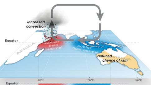
How precipitation is affected by the positive phase of the Indian Ocean Dipole around the Indian Ocean.
When the IOD is in its positive phase, warmer than average water pools in the western Indian Ocean, near the Horn of Africa, leading to increased rain in eastern Africa and more tropical cyclone activity in the western Indian Ocean. Conversely, cooler than average water near Indonesia and off the coast of northern Australia leads to less rainfall in southern and central Australia.
Twenty-nine Australian locations have already set new all-time record highs in 2019, including South Australia's capital, Adelaide, which soared to 47.7c on January 24, according to international records expert Maxmiliano Herrera.
Australia May Have Its Hottest Day on Record
Many inland areas of southern Australia are likely to have highs soar well over 40c for multiple days.If this doesn't set the all-time record, it could still threaten Australia's hottest December temperature record of 49.5c set at the Birdsville Police Station in Queensland on Christmas Eve 1972.
At a Glance
- A blistering heat wave will expand across Australia through the next week.
- The worst of the heat will extend from Western Australia to New South Wales and Victoria.
- The hottest locations could have highs reaching 50c
- National heat records could be set during this heat wave.
Saturday, December 14, 2019
Posted 14th Morning:


Churu.. Readings as on 14th Morning: Max 13.3c and Min 12.5c.
Churu was the coldest in the day in the northern plains at 13.3c.
Maharashtra minimums:
Some Local mnimum s on 14th:
Colaba (Mumbai ) 19.5c, Santa Cruz (Mumbai ) 18c, (Mumbai) 15.9c, Panvel 15.7c, Aurangabad 15.5c, Pune 14.8c, Matheran 14.8c. Nasik 13.6c,
WD has moved away..expecting Night temperatures to fall in the North now., to single digits.
Maharashtra towns will see a fall of around 2c from the above readings on 14th /15th Night...
---------------------------------------------------------------------------------
On the Other hand....


Uttarakhand weather: Nainital, Mussoorie witness season's first snowfall
Churu was the coldest in the day in the northern plains at 13.3c.
Maharashtra minimums:
Some Local mnimum s on 14th:
Colaba (Mumbai ) 19.5c, Santa Cruz (Mumbai ) 18c, (Mumbai) 15.9c, Panvel 15.7c, Aurangabad 15.5c, Pune 14.8c, Matheran 14.8c. Nasik 13.6c,
WD has moved away..expecting Night temperatures to fall in the North now., to single digits.
Maharashtra towns will see a fall of around 2c from the above readings on 14th /15th Night...
---------------------------------------------------------------------------------
On the Other hand....
Australia !!..country to swelter in heatwave with temperatures above 40C next week

Friday, December 13, 2019
Posted Friday 13th Morning:
Rainfall in North India as on today morning 24 hrs:
Jammu 97.4 mms, Pathankot 63.6 mms, Amritsar 49.4 mms, Chamba 48 mms, Palam 40.2 mms, Jallandhar 38 mms, S'jung 33.5 mms, Moradabad 31.4 mms, Kullu 30.8 mms, Srinagar 24.5 mms, Dehra dun 20.1 mms, Nainital 20 mms, Meerut 16.8 mms, Lucknow 16 mms, Shimla 12.8 mms,
Rajasthan many places between 7-10 mms.


A sheet of snow covers the area around Kedarnath shrine
Thursday, December 12, 2019


Tuesday, December 10, 2019
Climate v/s Weather v/s Climate Change...10th December
Every season a powerful storm impacts our region, there tends to be a common types of responses. If a storm brings heavy rains and damaging gale winds, some claim it is " climate change".
In the event a heat wave or other warm-weather type of event impacts the area, others claim climate change is verified.
In truth, neither of those outcomes are true, because weather events do not directly connect to climate.
So, what is weather, and how is it different than climate?

Weather
To put it in one sentence, weather is what all of us experience on a daily basis.
Weather describes the atmosphere at a specific place and time, including temperature, pressure, humidity, sunshine, rain, or cloud cover, winds, hail, snow, flooding, blizzards, thunderstorms, heat waves, hurricanes etc.
Meteorologists use various tools to take real-time observations of these variables on a minute-to-minute basis.
One way to think of things is that weather is what you get, whereas climate is what you expect.
Climate
While weather describes the atmosphere down to the minute, climate describes the average conditions expected at a specific place at a given time.
Climate is most frequently used on a 30-year scale, averaging together weather information such as pressure, temperatures and precipitation.
This is how the average high and low temperatures are computed for each day of the year.
Weather reports and readings mention the "average temperature" for a day, or mention that the forecast for the day is either warmer or colder than average.
Climate data can help us find out which parts of the country are typically hot and humid or warm and snowy at a particular time of year. By reviewing climate averages at a specific place, we can compare current or recent weather information to the past to help us describe whether our summer was hotter or colder than normal, for example.
Conclusion
It is incorrect to say that ONE particular storm/Event is a direct result of climate change, in one way or another, because they're different.
Climate does not cause a heat wave to impact the country, or a "Cloud burst" due to "Vortex" to impact a particular place, for example. However, over time, climate normals do change.
If the temperature were to consistently climb above 35-40c on a regular basis in June, July, and August, more often than they do now in a particular region, then this would cause 30 year "average high temperature" to rise in response.
So, while climate and weather are quite different in their execution, they are directly related.
Reference from Anthony Macari, STORM TEAM 10
Sunday, December 08, 2019

Posted Sunday 8th Evening;
A Western Disturbance (WD) is approaching the Indian Sub Continent from the West.
It is likely to be over North Pakistan on the 9th/10th. of December. With the formation of an induced Low over West Rajasthan and adjoining Pakistan, it may be possible that the whole of Pakistan may be covered with clouds and precipitation on the 11th/12th.
Karachi may get some rains and Thunder shower on 11th and 12th.Though light to moderate.
Northern hills regions of India, that is, Kashmir, H.P, and Uttarkhand will get a good sprinkling of snow on 12th.
With the induced low moving E/NE, the plains of Punjab, Haryana, Delhi, Rajasthan, North M.P. and U.P. will get rains and thundershowers on 12th/13th..
Cold Day conditions will prevail over the entire Northern region with the advance of WD. Delhi dropping to below 20c in the day on 13th.
The regions of M.P, Gujarat and Maharastra will witness cold N/NW winds from the 12th, with fall in temperatures.
Also, South Gujarat Coastal areas will see a drop in temperatures.
Mumbai:
Maharashtra, which has yet to get the real winter feel till today, will see a change of winds from the 12th. As is commonly rumored, with so much rain till late November, with almost a 5 month rainy season, why is is it not getting cold ? Well,it is the lack of proper "winterly" North winds.
With various system in the Arabian Sea bringing in rains and moisture into the regions, we had no proper push from the breezy North. In fact, all winds were headed from the East to the West, blowing off the Land along the West coast (Mumbai).This kept the temperatures high. Dry air from the North was not able to penetrate South of Gujarat.
Mumbai constantly saw temperatures along the 33-35c range thru November till today. Many All Time Records (High) were achieved in November along the West coast as a result. And today (8th Dec), Penambur touched its ATR for December also by recording 37.5c.
Now, from 11th ..for almost a week, the WD trough will dip south with the induced Low, and with cold dry N/NW winds, lower the Mumbai and the entire regional temperatures of Gujarat/ Maharashtra and M.P.
After 12th Mumbai will drop to 30c in the day and around 17/19c at night. Pune/Nasik/Aurangabad will see a fall to 27c - 10/11c.
These 3 and many other Maharashtra cities had the warmest November in a decade.
A fresh Low Pressure has formed in the South Arabian Sea at 9N and 62 E . This , AS-7, has concentrated into a Depression and likely to Concentrate more next 24 hrs. Track will be W/NW, away from the Indian Coast.
Muscat had sporadic showers on Sunday. The max in the day was 23c and about 5/6 mms of rain.
Rains will decrease from Monday.
U.A.E. expected to get showers on Monday/Tuesday.
Subscribe to:
Posts (Atom)
Raigad District Talukawise Rainfall (mm) – 03 July 2026 (Highest to Lowest) Rainfall (mm) Pen 150 Shrivardhan 145 Tala 137 Uran 125 Mhasala ...

-
 Much Awaited Monsoon Analysis to Date from ..None Other than Our GSB..on "Stats and Analysis" Page..Just Recieved On Saturday ...
 -
 Short Narration: Monday 1st/Tuesday 2nd : The heaviest rains are in Madhya Maharashtra, Marathwada, North Interior Karnataka and No...
