
30th June 2023
Extremely heavy rains lashed Junagadh city of Gujarat 263mm reported during last 24 hours ending 6 am on 30 June and more 70mm till 1 pm today...Many low lying areas of city flooded now, local water reservoir located in Girnar foothills area overflowing on June 29 evening...After many years it's happening in June mostly happens in July or in August month...!!!
Junagadh got 551mm rainfall in June which is 54.41% of total annual average..!!
Normaly Girnar mountain has received more rain than city. By seeing the intensity of flood water in Girnar foothills area, we can estimate around 450 mm rain reported in Girnar mountain during last 31 hours
આજે સવારે 6 વાગ્યે પુરા થતા 24 કલાક દરમ્યાન જૂનાગઢમાં 263mm એટલે કે સાડા દસ ઇંચ વરસાદ નોંધાયો...જ્યારે આજે સવાર થી બપોરે એક વાગ્યા સુધીમાં વધુ 3 ઇંચ વરસાદ પડી જતા છેલ્લી 31 કલાકમાં સાડા તેર ઇંચ વરસાદ થી શહેરમાં જળબંબાકાર જેવી સ્થિતિ ઉભી થઈ છે, અનેક વિસ્તારોમાં પાણી ભરાયા... દાતારની પર્વતમાળામાં આવેલ વિલિંગ્ડન ડેમ 29 જૂન ની સાંજે છલકાઇ ગયો...ઘણા વર્ષો પછી આ ડેમ જૂન મહિનામાં જ છલકાઈ ગયો છે જે મોટેભાગે જુલાઈના અંતમાં કે ઓગષ્ટમાં જોવા મળે છે.
ગિરનારના પહાડો પર આજે બપોરે એક વાગ્યા સુધીમાં છેલ્લા 31 કલાકનો 16 થી 18 ઇંચ સુધી વરસાદ પડયાનું અનુમાન છે
Report from Vag..Raninga (Junagadh)
Posted 30th June Morning
Mumbai :
Monsoon arrives late, almost on the last date on record, but shows a recovery and covers up the June deficit...Scruz June rain total 550 mms,( Normal 526 mms) in +ve zone now!😊
Lakes at 10% Storage., same as 2022 on date...Still filling up
Outlook for Weekend 30th June, Saturday July, Sunday 2nd July:
Orange (Medium)Alert for Friday 30th:
* Friday 30th: Fairly frequent heavy rain showers ( 60 - 100 mms) continue thru the day with gusty winds during showers.
* Saturday 1st July: Frequent intermittent showers in the day. Decreasing frequency by evening. ( 30-50 mms).
* Sunday 2nd July : Less Frequent rains with some bright intervals.
Pune:
*Friday 30th. Moderately brief heavy showers. ( 20-30 mms). Cool day at 26°c.
*Decrease from Saturday ( around 10 mms ).
------------------------------------------------------------
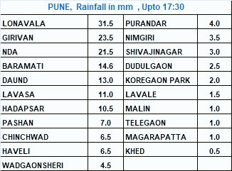
Maharashtra Ghat region getting some much needed heavy rain
Below readings till 8.30 am
Shirgaon (Bhor taluka, Pune dist.) 168 mm
Khireshwar, Malshej 111 mm
Koyna Nagar 84 mm
Kumbhi Dam 90 mm
Bhimashankar 112 mm
Davdi Camp, Tamhini 122 mm
Mahabaleshwar 128 mm (June total 728 mms).
Jor 108 mm
Interior Maharashtra & Marathwada:
Proper rains for agriculture still elusive. No meanigfull rains till Monday at least.
-------------------------------------------------------
Gujarat:
Heavy rains on Friday (today)for Saurashtra, Kutch, Bharuch, Ahmadabad and Surat/Valsad.
Weekend definitely decreasing rains in Saurashtra after the deluge.
But heavy rains, specially Friday (today), in Gujarat Region ( Bharuch)..getting upto 50 to 70 mms.
Rains little less on Saturday and Sunday.

26th June Posting:
Prominent Rain Amounts today:
Ganganagar 42.6C/23.1C...76mm
Amritsar 114mm
--------
Honnavara 138mm
-----
Nagpur 78mm
Bhopal 77mm
Raipur 71mm
Kota 69mm
---------------------------
Vigorous Monsoon advance in Pakistan Punjab!
NEW RECORDS SET IN LAHORE:
Lahore Airport:
All Time Min: 17.5 °C (26-06-2023)
Old: 18.0 °C (17-06-2011)
24RF: 226.0 mm (26-06-2023)
Old: 98.0 mm (29-06-2011)
All Time Monthly RF: 387.5 mm till 9:00 am
Old: 224.1 mm (June 2011)
Lahore PBO:
24RF: 161.8 mm (26-06-2023)
Old: 125.5 mm (18-06-1894)
All Time Monthly RF: 283.9 mm till 9:00 am
Old: 208.6 mm (June 1996)
Posted 25th.
With the help of a low pressure building up in the North West Bay, the coast trough and the establishing of a Monsoon trough in the north, the Monsoon has advanced into Mumbai and all of Maharashtra .
Torrential Rains on 24th heralded the Monsoon into Mumbai. With Scruz recording a massive 176 mms, Colaba 86 mms.
Highest was Dahisar with 223 mms
Only 2 lakes supplying water to Mumbai, Tansa & Vihar got more than 100 mms rain.
-------
Rain in Mumbai today (25th).
* 5 (BMC gauge) locations' rainfall (From 5.30am to 5.30pm)*
MUNICIPAL HEAD OFFICE *38mm*
COLABA FIRE STATION AND MAROL FIRE STATION *33.5mm*
MALABAR HILL *33mm*
SANTACRUZ SWM WORKSHOP *31mm*
BHANDUP COMPLEX *31mm*
-----------
With the low pressure strengthening and moving West inland, we see the Konkan coast and parts of Vidarbha getting very heavy rains next 3-4 days.
25th June..
With the Monsoon trough getting established over NW plains...Monsoon moved into UP, Delhi NCR and east Rajasthan


It's not very often that we see this..in fact in the author's last 55 years of weather experience, I've noticed only on two occasions
1. When Delhi got the Monsoon a day before Mumbai
2. On the same day.

23rd June update:
With Monsoon winds now regaining the required strength gradually ( thanks to the fizzling away of "Biparjoy "), we see the seasonal off shore trough gaining moisture along the West Coast and heralding in the Monsoon over N. Konkan, Mumbai, and South Gujarat from 25th.
Next 7 days see good rain over these regions.
Mumbai:
*Sultry days over !
*Rains begin on 24th. and gradually rain frequency increasing by 25th.
*Monsoon advance into Mumbai on 25th (finally) 😥😌
*Heavy rain on 27th/28th..could accumulate to more than 100 mms in these 2 days. Possible localised flooding in vulnerable locations.
*Let us hope no "unwanted " onset date record is surpassed.
Pune:
* Monsoon rains and cooler days after 25th, Sunday.
*Regular Intermittent Rains 🌧 from Sunday, with increase on 27th.
*Cool days Next week at 25°c.
Bharuch:
*Long wait could be over by 26th ( for the Monsoon).
*Frequency of Rains will increase from 26th. Very heavy rain falling on 29th/30th.
*Cooler days at 30°c.
Valsad: With Monsoon advance. extremely heavy rains from 27th to 30th..can accumulate in excess of 150 mms.
Surat: Regular Intermittent Rains from 25th. Substantial increase next week.
---------------------------------------------------------------
The latest All India Monsoon area covered as on 23rd 👇

22nd night post
Some good news for Mumbai..at last 😀
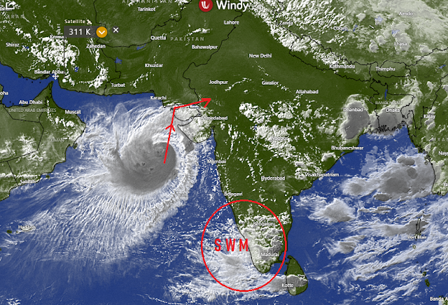
The South Westerly winds regain strength along the Konkan coast after the effect of the Cyclone is gone.
Check the estimated strength on 25th👇
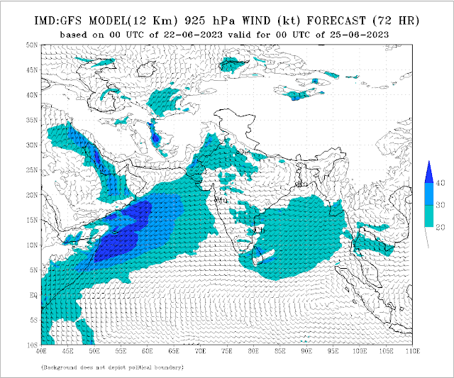
Hence, we can expect the Monsoon to now advance into North Konkan and Mumbai by 25th June.
Rainfall will increase in Mumbai from 23rd night, and from 24th, Mumbai will get frequent showers.
A definite change in weather from 25th.
The onset date may tally with the most delayed monsoon arrival for Mumbai, which was 25th June in 1959 and 2019.
But this does not necessarily mean weak rains.
21st June..Morning:
SW surface wind flows are weak. Typical weak monsoon currents.

Also Depression, ( remnant of cyclone) crashing onto Himalayan ranges is normally a "break monsoon " phenomena.

Not normally occurring in June.
Vagaries estimates this situation will change by the 24th, when the depression near the Himalayas fizzles out.
Monsoon currents will gain strength after 24th, and will advance over into North Konkan, including Mumbai/Pune by 25th.
Interesting point: 25th June is the record date for the most delayed monsoon arrival for Mumbai by IMD in 1959 & 2019. However, Vagaries had observed 27th June as Monsoon arrival in Mumbai for 2019.
Monday 19th June morning Satellite image

Rainfall over coastal Karnataka, Goa and south konkan may increase gradually from 23rd/24th June.
मराठवाड्यात २८ ते ३० जूनपर्यंत मान्सूनचे आगमन होण्याची शक्यता आहे. या हंगामात 3 महिन्यांच्या पिकाची पेरणी करणे योग्य ठरू शकते.

16th Night Posting
With the Cyclone now having crossed into Kutch and weakened, where is the Monsoon ?
West coast is looking clear and "non monsoon" like !
NE in full swing.
No Monsoon current strengthen signs along West coast till 21st seen.
No meaningful Monsoon rains in Maharashtra or Goa till 22nd at least.
Wait for proper Mumbai monsoon till 23rd at least 😣

14th June...Evening Post:
"Biparjoy", Very Severe Cycclone now at 21.9N and 66.5E...position shown.in CIMSS Image👇

Winds estimated at 140-150 kmph . Tracking NNE towards the India/Pakistan Border.
Gujarat Alert issued in morning post below. 👇
Biparjoy rainfall to Gujarat.

Karachi: Very squally winds and rough seas on 15th/16th. Moderate rainfall for 2 days Heavy rains in Southern Sindh adjoining Kutch.
---------------------------------------------------------------------------------------------------------------------------
Mumbai:* No proper Monsoon advace till 19th.! Monsoon current is shallow and needs to be established deeply.
* In terms of rainfall , we are yet to see proper Monsoon
*Large scale circulation shifts are happening in the background
* Hence,"On/Off" showers with warm umid days at 34c and "Real Feel" at 38c.
Pune:
* Partly cloudy, with gusty winds. Some rains in patches. No proper monsoon advance seen till 19th.
Farmer's Note: SambhajiNagar(Aurangabad) District: No proper Monsoon till 19th at least. But very windy (adding to dehumidfying the soil) and warm/hot days . around 38c. No rushing into sowing seeds next few days.
शेतकऱ्याची नोंद: संभाजीनगर(औरंगाबाद): किमान 19 तारखेपर्यंत योग्य पाऊस नाही. पण खूप वादळी (माती कोरडेपणा वाढवते) आणि उबदार/गरम दिवस. सुमारे 38c.बियाणे पेरणीसाठी घाई करू नकाSome rainfall readings ending 8:30am on 14/06/2023 in Mumbai Metropolitan Region and nearby areas below in mm:
1. Palghar AWS:50
2. Kausa:46
3. Airoli & Ghansoli:38
4. Dombivli: 36
5. Gawanpada & Nerul:33
6. Kandivali & Naupada(Thane):32
7. Borivali: 30
8. Dahisar:29
9. Kopri:27
10. Govandi & Mankhurd:25
11. Vikhroli & Badlapur (Vag Pvt Reading):24
12. Poisar:22
13. Malad & Sion:20
14. Mulund , Bhayandar & Pawne:18
15. CSMT , Belapur & Vashi: 17
16. Chembur:16
17. Ghatkopar & Memonwada:15
18 .Grant Road , Sandhurst Road & Matunga:14
19. Malabar Hill:13
20. Kurla ,Byculla & Marol: 12
21. Reay Road , Worli & Bandra:11
22. Colaba IMD, DN Nagar Versova, BhauchaDhakka & Parel:10
23. Andheri & Goregaon:8
24. HajiAli:7
25. Santacruz IMD:6
26. Powai:5
27. Nariman Point:4
Data Credits: MCGM & IMD
Compiled By: Vagarian Abhishek Apte
14th June scenario

Gujarat forecast in view of cyclone Biparjoy:
Landfall is expected on 15th June.
Rain and winds expected to increase for Kutch region.
Very heavy rain of 150-200 mm and strong winds of 120-130 kmph with gusts up to 140-150 kmph likely from tonight.
Saurashtra: South/southwest winds of 80-90 kmph, with gusts up to 100-120 kmph possible around Devbhoomi Dwarka. Porbandar may see 70-90 kmph winds. Rain can be moderate around Porbandar, but heavier towards Devbhoomi Dwarka.
Sea conditions will be extremely rough with big waves.
Biparjoy will weaken as it tracks east/northeast after landfall.
Rain and area of gusty winds will spread eastwards and northwards after landfall.
North Gujarat and South Rajasthan can see heavy to very heavy rain of 100-150 mm during 16th-17th June. Some places like Mount Abu can get even higher localized rain.
Moderate to heavy rain will spread into Madhya Pradesh over the weekend.

Biparjoy pours over Gujarat. 😧👉
Record-breaking Cyclone Biparjoy and Cyclone activity in the North Indian Ocean
Cyclone Biparjoy is now the longest-lived cyclone (with winds at least 35 knots) in the Arabian Sea (including all months) in the satellites era (since 1982).
Top 2 longest-lived cyclones in the Arabian Sea (all months)
1. Biparjoy (2023): 198 hours
2. June 1998 cyclone: 186 hours
Cyclone Biparjoy is the longest-lived cyclone (with winds at least 35 knots) in the Arabian Sea in the pre-monsoon season in the satellite era (since 1982).
Top 3 longest-lived cyclones in the Arabian Sea in the pre-monsoon season (April-June)
1. Biparjoy (2023): 198 hours
2. June 1998 cyclone: 186 hours
3. Vayu (2019) and May 2001 Cyclone: 150 hours
Cyclone Biparjoy is the longest-lived cyclone with at least category 1 cyclone strength (winds>64 knots) in the Arabian Sea in the satellite era (since 1982, including all months). It is maintaining at least category 1 cyclone strength for 150 hours (as of 13 June 5:30 pm IST).
Cyclone Biparjoy accumulated cyclone energy (ACE) is now 22.3, this is the highest ACE by a north Indian Ocean cyclone in the satellite era (since 1982).
Top 3 highest ACE in the pre-monsoon season (April-June) in the north Indian Ocean
1. Biparjoy (AS, June 2023): 22.3
2. Fani (Bay, April 2019): 21.96
3. Amphan (Bay, May 2020): 19.75
Cyclone Biparjoy accumulated cyclone energy (ACE) is now 22.3, this is the highest ACE by a pre-monsoon Arabian Sea cyclone in the satellite era (since 1982).
Top 3 highest ACE in the pre-monsoon season in the Arabian Sea
1. Biparjoy (2023): 22.3
2. Gonu (2007): 19.62
3. May 1999 cyclone: 17.08
Cyclone Biparjoy accumulated cyclone energy (ACE) is also the 3rd highest by any cyclone in the Arabian Sea (including all months) in the satellite era (since 1982).
Top 4 highest ACE in the Arabian Sea (including all months)
1. Kyarr (2019): 24.71
2. Chapala (2015): 23.41
3. Biparjoy (June 2023): 22.3
4. Gonu (June 2007): 19.62
The accumulated cyclone energy (ACE) in the north Indian Ocean in this pre-monsoon season (April-June) has now reached 37.9 (as of 14 June evening). This is the highest ACE in the north Indian Ocean during the pre-monsoon season in the satellite era (since 1982).
Top 3 ACE Years in the north Indian Ocean during the pre-monsoon season are:
1. 2023: 37.9
2. 2019: 37.67
3. 2007: 23.2
This is only the second time in recorded history (since 1982) that the Arabian Sea and the Bay of Bengal have hosted a category 3 or higher intensity cyclone in the same pre-monsoon season. Cyclone Moch (category 5 in the Bay of Bengal in May 2023) and Cyclone Biparjoy (Category 3 in the Arabian Sea in June 2023). Previous to this, only such incidence was in 2019.
Note: All data is based on JTWC records

Latest on "Biparjoy" as on 12th Evening.
Very Severe Cyclonic storm, Biparjoy" , lost some steam to a small extent, as its winds are now surpassed the peak and slightly less at 145-155 Kmph. Cat.2. Was anticipated yesterday after touching about 20N.
As dry air entry is increasing, the overall convection cover is reducing. A band of convection still covering the circulation, the JTWC terms the core as a "Quasi Eye".
With the ridges alongside, expected track..heading towards the North Kutch/International border region.
Alert: Very heavy rainfall and squally winds in Kutch, Western Saurashtra from 14th. Rains commence into North Gujarat and South Rajasthan from 16th.
Karachi & Southern Sindh will get heavy showers and rain from 14th to 15th, with squally winds.
Monsoon advance beyond South Konkan may be halted for a few days, as the Cyclone moves inland and disturbs the gradient along the West Coast.
Mumbai:
*Next 3/4 days will get light to medium Pre Monsoon showers. Squall winds around 30 Kmph.
*A slight reduction in rains after Wednesday 14th. No major increase in rainfall this week.
*A distinct absence of the usual thunderstorms is noticed. This is as "multi Layer" clouds are not seen. But thunder activity will soon resume.
*Days will be a shade better at around 33/34c, but humid. Real feel will be high (38c). Nights around 27c will be warmish.
*Wait for proper Monsoon is frustrating !😖
Pune: With warm days around 35c, will be almost dry, with few localised scattered rain patches.
Goa: Monsoon looses steam after Wednesday 14th...with little rains as the pull of the system reduces.
Note by Vag.Dr.Vineet Kumar..co author, vagaries
Cyclone Biparjoy now is at least a Category 1 cyclone (hurricane strength) for 114hrs. This is the longest duration of arabian sea cyclone with at least category 1 cyclone strength (>65 knots) in satellite era (since 1982) as per jtwc
Cyclone Biparjoy is also the fourth longest lived cyclone in the premonsoon season in Arabian sea in satellite era (since 1982).
Currently it is active with winds at least 35 knots for 144hrs as per jtwc.
-------------------------------
11th June 4 pm IST
"BIPARJOY"...Cat.3, Core Winds 165/175 Kmph..Gusting to 195 Kmph, Core Pressure estimate 960 hpa,

ALERT FOR KUTCH AND SAURASTRA: Squally winds at 70-80 Kmph and very rough seas from 11th June.
Vag.Vineet informs:
Biparjoy is also the strongest cyclone in Arabian Sea (including all months) after cyclone tauktae as per both IMD & JTWC
Also this is the 8th category 3 cyclone in pre-monsoon season(March-June) in Arabian sea since 1980, out if which 7 have formed after 2000
The accumulated cyclone energy this season so far in north Indian ocean is 312% more than climatology
------------------------------------------------------------
Mumbai: *Partly cloudy with few pre-monsoon showers or thundershowers. Squally winds around 35-40 Kmph.
* Cyclone on 11th Evening 550 Kms West of Mumbai in the Arabian Sea. Moving towards Kutch.
Dr.vineet's Page Updated with Cyclone information.
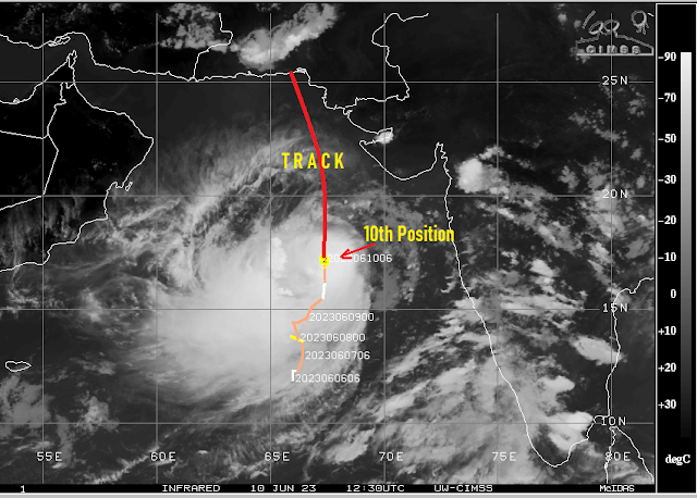
10th June 8 pm IST
1."Biparjoy".
Our friendly cyclone is now a "Very Severe Clone" with dangerous winds estimated at 155-165 kmph..at the Centre of the system. Core Pressure estimated at 965 hpa.
Track of "Biparjoy"
--------------------------------------------------------------

As "Biparjoy" tracks Northwards, gusty winds will affect the Konkan Coast and later in 2 days very gusty winds will sweep Western Saurashtra and Sindh Coast.
Gujarat:
*Needs to be on alert for possible impacts from Cyclone Biparjoy
*Veraval/Diu to Dwarka coast can see very gusty winds of 50-60 kmph from Monday 12th June. Winds can exceed 65-70 kmph by Tuesday 13th, as the cyclone comes closer to the coast on its track towards Sindh region.
*Sea will be very rough.
*Kutch coast to also see very gusty winds and very rough sea conditions from 13th to 15th June.
*Rainfall will be light to moderate during these days. Interior Saurashtra may get some thundershowers.
More details by tomorrow
Karachi: Likely to gat affected by Cyclone as the movement is estimated towards Sindh Coast. Very strong gusty winds and rough seas from Tuesday. Rains in heavy downpours also from Tuesday Night/Wednesday..could accumulate to 60-80 mms in 2 days.
Mumbai:
*Mumbai can see some gusty winds from South of 30-40 kmph at times. Some gusts may touch 50 kmph or higher.
*Sea will be rough during high tide.
*Chance of some showers, but no major relief from heat+humidity.
* Wait for proper Monsoon tll at least 16th June.
* Santacruz saw a night temperature of 29.6c. Almost the warmest night on record ( S'Cruz:10th June 2007 was the warmest at 30.3c. Colaba: 30.2c on 10th June 2016 (As per Vagaries' records.).
2.SW Monsoon has advanced into Coastal Karnataka and into the NE states. BB-2 formed quickly and pulled the SW Monsoon into the NE States. Now fizzled out after crossing into Myanmar.
Now, likely to advance into Goa and South Konkan by Tueday 13th June.
Interior Maharashtra will not receive Monsoon showers till 18th at least...Some local pre monsoon showers in Marathwada on 15th/16th. Sowing should nt start now.
Even Interior South Peninsula will have to wait for the proper monsoon
मराठवाड्यात किमान १८ तारखेपर्यंत मान्सूनच्या सरी पडणार नाहीत... १५/१६ रोजी मराठवाड्यात काही स्थानिक मान्सूनपूर्व सरी पडतील. पेरणी आता सुरू करू नये.

9th June...afternoon Analysis
"Biparjoy"
 ADVANCED DVORAK TECHNIQUE
                    ADT-Version 9.1
         Tropical Cyclone Intensity Algorithm

             ----- Current Analysis -----
     Date :  09 JUN 2023    Time :   080000 UTC
      Lat :   15:04:49 N     Lon :   66:49:03 E


                CI# /Pressure/ Vmax
                3.7 / 989.1mb/ 59.0kt


.png)


