
Posted 30th night
On seeing this UAC , Monsoon progress seems likely in 48 hrs

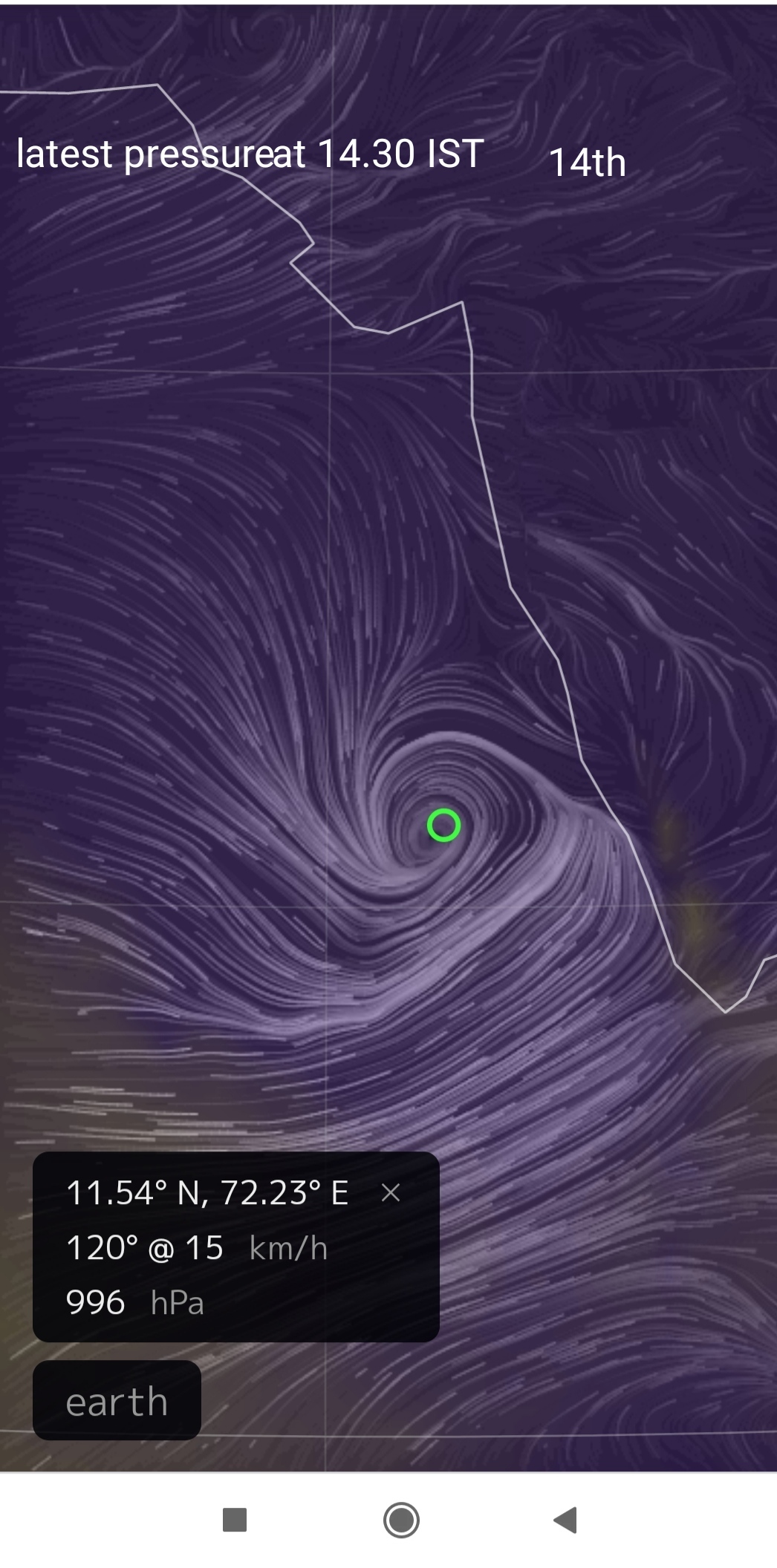
Posted 30th May 2021:
Weather for Aurangabad and Marathwada Farmers for 4 days from 30th May:
Pre Monsoon Thunder Showers are expected in Aurangabad Region and Marathwada for the next 4 days. These are not the Monsoon , but only pre monsoon. Will benefit soil conditions for sowing. Sowing to be done after proper Monsoon is set..maybe around mid June.
---------------------------------------------------औरंगाबाद आणि मराठवाडा येथील 30 मे पासून 4 दिवस हवामान:
30 मे 2021 रोजी पोस्ट केलेले:
औरंगाबाद आणि मराठवाडा येथील 30 मे पासून 4 दिवस हवामान:
औरंगाबाद विभाग आणि मराठवाड्यात पुढील चार दिवस पूर्व मान्सून थंडर सरी बरसण्याची शक्यता आहे. हे मान्सून नसून केवळ मान्सूनपूर्व असतात. पेरणीसाठी मातीच्या परिस्थितीचा फायदा होईल. योग्य पावसाळा तयार झाल्यावर पेरणी करा. जूनच्या मध्यभागी.
-----------------------------------------------------------------------------------------
With pre monsoon rainfall and lower and upper winds fulfilling the conditions slowly, a weak monsoon current is entering Kerala next 48 hrs...around 1st June.(Delayed by a few days due to non fulfilling parameters
Below is the rainfall in Kerala as on 30th morning.


Extremely heavy rain continues in Odisha for the 3rd day due to Cyclone Yaas.Rainfall ending at 8.30am today, 27th....MIN 100mm
Compiled by Vagarian Mitan ( Bhuvaneshwar)
Bhanjabasa(Mayurbhanj)-383mm
Ramatirtha(Mayurbhanj)-358mm
Bareipani(Mayurbhanj)-332mm
Kabatghai(Mayurbhanj)-307mm
Nawana North(Mayurbhanj)-279mm
Joda(Keonjhar)-269mm
Josipur (Mayurbhanj)-255mm
Kulipal(Mayurbhanj)-222mm
Kendumundi(Mayurbhanj)-219mm
Lathkatha(Sundargarh)-208mm
Champua(Keonjhar)-205mm
Keonjhargarh (Keonjhar)-198mm
Panposh(Sundargarh)-197mm
Basudevpur (Bhadrak)-195mm
Thakurmunda(Mayurbhanj)-190mm
UBK(Mayurbhanj)-182mm
Chandikhol(Jajpur)-175mm
Jenabil(Mayurbhanj)-171mm
Karanjia(Mayurbhanj)-168mm
Chahala(Mayurbhanj)-166mm
Podadiha(Mayurbhanj)-154mm
Rajgangapur(Sundergarh)-141mm
Nawana south(Mayurbhanj)-140mm
Sawampatna(Keonjhar)-138mm
Deoghar (Deoghar)-131mm
Satkosia(Mayurbhanj)-124mm
Tiring(Mahurbhanj)-121mm
Udala(Mahurbhaj)-113mm
Barkot(Deogarh)-113mm
Gurundia(Sundergarh)-113mm
Hatadihi(Keonjhar)-112mm
Tihidi(Bhadrak)-112mm
Pallahra(Anugul)-112mm
Ghatogaon (Keonjhar)-103mm
Luhunipara(Sundergarh)-102mm
Sarpada(Keonjhar)-100mm
Soro(Baleshwar)-100mm
Posted 26th May night:
Yaas weakening fast and moving NW into Jharkhand/Bihar and East U.P...
Once cyclone Yaas dissipates, which is expected around May 28, the ocean and atmospheric conditions would once again normalise and favor the advancement of the monsoon
Monsoon has moved upto Maldives and South Sri Lanka.
Now, seeing the OLR box ( 5N - 10N and 70E- 75 E) we see favorable values of below 200 wm2


Judging by this, we feel the SWM will advance to Kerala, as a weak current on 27th May
Will remain weak and stagnant till 1st June at least. Giving a few days for the off shore trough to stabilize,and the pressure gradient to establish.
Forecast for 27th Thursday, 28th Friday, 29th Saturday.
Mumbai: Proper Monsoon still 12- 15 days away..around 8th-10th June. But pre monsoon showers may start by 4th June..+- 2 days.
Warm and humid next few days.
Pune: Partly cloudy. A mild shower in some parts on 28TH/29TH possible.
Monsoon proper expected after 8th June.
Goa: As the off shore trough forms, Goa will start with pre monsoon from around 29th or 30th.
Posted 26th May
Cyclone Yaas made landfall today between 9:30am-12 noon with a wind speed of 130-140 kmph at the north Odisha coast as Cat 1..and on estimated track

Rainfall in Odisha till 8:30 am
Kusumi: 300 mm
Chandbali: 288 mm
Rajnagar: 275 mm
Ersama: 271 mm
Rajkanika: 251 mm
Tihidi: 242 mm
Kujang: 226 mm
Paradip: 200 mm
This is only the fourth pre-monsoon cyclone in the satellite era (1980 onwards) and second pre-monsoon cyclone after 1989 to hit Odisha coast with at least severe cyclonic storm strength (winds greater than 48 knots).
Posted 24th 12 midnight
Yaas position at 17N and 89 E.
But study the map below..Seems Might Cross as Cat 1


Posted 24th May...1 pm
BB-3, expressed as a Depression till yesterday, now satellite images showing tightening of the pressure around the centre.. Thus rapidly formed into a Cyclone "Yaas" with estimated core pressure at 990 mb and core winds estimated at 65-75 kmph.
Tracking towards the Odisha/West Bengal border line....as Cat 2/3

Balasore 300-350mms, Bhubaneshwar 275-325 mms....can vary depending on the intensifying of the Cyclone.
Kolkata can expect 80-100 mms in the time frame.
Mumbai: No cyclone threat to Mumbai. Partly cloudy weather for 24th -27th with light drizzles in some parts of city ..very scattered.
Pune: Partly cloudy with chances of thundery development in some parts of Pune on Monday/Tuesday.
Posted 21st May 1 pm :
Low Pressure will form in the Bay location 15N and 95E off SW coast of Myanmar.
Due to conducive atmosphere, where the TCHP , Water heat content, is more than 100kg/cm2 in major portions of Bay (except extreme North Bay), very rapid development to a cyclone stage ( Cat 2/3 possible) within 2-3 days from forming.
Seeing the above conditions, Cyclone (Yaas) may hit Odisha/West Bengal coast around 25th/26th May.
South West Monsoon will advance into South Andamans by 22nd May.
Monsoon Likely in Kerala ,as a weak current around 26th...Needs to be monitored.
Weekend Weather:
(*Real feel of any temperature in the forecast means how the temperature will feel to your body. Basically, temperatures that thermometers record and the that our body feels can be different under wind/humidity/cloud conditions etc).
Mumbai ; Sunny with patchy clouds and humid, feeling discomfort and sweaty.
. Real feel* 37/38c.
Pune: Partly cloudy with hot day around 37c , with real feel* around 37c. Slight drizzle possible in patches or parts of Pune.
Lonavala: Getting cloudy by afternoon /evening. and warm days around 34c. Nights around 22/23c.
Goa: Partly cloudy with humidity at 85-90%. Real feel* will be 38c.
-----------------------------------------------------------------------------------
The chief amount of rainfall from remnants of Tauktae:
The chief amount of rainfall
Uttarakhand: Nainital-117.0; Mussoorie 103.0; Mukteshwar-85.0; Haldwan 83.
Haryana, Chandigarh & Delhi: Jhajjar-117.0; Gurgaon-115.0; Mewat-84.0; Faridabad -80, Narnaul-77.0
West Uttar Pradesh: Bareilly 146.0; Meerut-85.9; Aligarh-71.6; Muzzafarnagar 69.
East Uttar Pradesh: Gorakhpur 68.0 ,Varanasi-82.8; Sultanpur-73.4; Mirzapur 72
West Rajasthan: Nagaur-68.0 o
East Rajasthan: Dholpur-103.0; Alwar-90.0; Jaipur-80.0; Dausa-70.0; Sikar- 70.
(Source IMD)


North India Today.. By Navdeep Dahiya

See Gujarat Rain Amounts from Tauktae below this article.. Posted
Posted 19th May afternoon:
Mumbai: The "Post Cyclone" passing showers continue even on the 19th Wednesday. These are due to the strong South Westerly winds still lashing the West Coast , heading towards the System, now as a Depression over West M.P....
The passing showers will continue till the erstwhile system weakens...maybe another day.
But in patches, Mumbai one next day will have a few passing showers with bright sunny periods. Getting hotter.
This is not the Monsoon !
---------------------------------------------------------------------------------------------------------------------------
Post Cyclone showers also continue in some patches of Madhya Maharashtra, Gujarat and N.I. and Coastal Karnataka.
----------------------------------------------------------------------------------
Bay of Bengal: Around 21st May, A Low pressure can form in the North- East Bay off the Myanmar coast at location at 15N , 95E..SW off Yangon. The will strengthen and move in days to come and move towards Bangladesh.
May cross as a Deep Depression/ Cyclone around 25th/26th..
This will attract good strong SW winds towards the system in the Bay from Below Sri Lanka (Bay Branch of Monsoon Cross Equatorial Winds). As seen in IMD Forecast Map.

The South West Monsoon will advance into the Andaman Islands on around 23rd May.
As regards the West Coast, stronger SW winds will develop off Kerala coast and CAN bring in a feeble current of the South West Monsoon around 27th/28th May...Needs Follow up though !
---------------+-+---+-+----------------+----++-+---+
Cumulative rainfall of Gujarat and Daman for the dates 17th and 18th May 2021 from the cyclone Tauktae
Compiled by Vag. Shitij (Surat)
1. Gir Gadhada (Somnath) 375
2. Una (Somnath) 347 mm
3. Umergam (Valsad) 332 mm
4. Daman 290 mm
5. Bhavnagar 244 mm
6. Palitana (Bhavnagar) 240
7. Bagasra (Amreli) 235 mm
8. Nadiad (Kheda) 232 mm
9. Pardi (Valsad) 183 mm
10. Savarkundla (Amreli) 171
11. Mahuva (Bhavnagar) 170
12. Valsad 169 mm
13. Olpad (Surat) 168 mm
14. Amreli 163 mm
15. Surat IMD 135 mm
16. Navsari 130 mm


Posted May 17th..9.45 pm IST
Finally.. "Tauktae" Makes Landfall near Jafarabad ( Amreli Dist) Gujarat.
(See Mumbai Monday Rainfall figures below)


Posted Monday 17th 11.30am
The Cyclone is currently 160 kms .. West/ North-West off Mumbai..Cyclone will move away NW from Mumbai slowly. By late afternoon we may see some decrease in intensity.

Monday morning 3 hrs rainfall till 11 am in Mumbai
Dadar (Pvt) 72mms, Vagaries club 56 mms, Nariman Point 56 mms, BMC office 53 mms, many places between 10 to 30 mms
Some interesting facts of this cyclone compiled by Vagarian Vineet
For the first time in the last 40 years, 4 consecutive years (2018, 2019,2020 and 2021) a pre-monsoon cyclone in the Arabian Sea. Data from: IMD Cyclone e-atlas
Cyclone Tauktae intensified by 45 knots in the last 24 hrs (16 May 0530 IST to 17 May 00 IST). This is the most rapid 24 hrs intensification by a cyclone in May month in the Arabian Sea after 1999. Data from: JTWC
Cyclone Tauktae current wind speed is 120 knots (as per JTWC estimates), this is now the strongest pre-monsoon Arabian Sea cyclone after 2010 and third strongest pre-monsoon Arabian Sea cyclone in the satellite era (1982 onwards): Data from JTWC
Cyclone Tauktae intensified from category 1 to category 4 cyclone in just 24 hrs.
First time after 1976 and only the second time since 1900, a cyclone in May going to hit Gujarat coast with wind speed greater than 35 knots. Data from: IMD Cyclone e-Atlas
Some more Interesting Facts compiled by Vagarian Vineet.. Only in Vagaries
This is the third cyclone in last 4 years in the Arabian sea in pre-monsoon season that has attained 100knots windspeed
Last 24hrs 5.30 pm to 5.30 pm Sunday..intensification now : 40 knots
This is the most intense intensification by a cyclone in May month in the Arabian sea after 1999
Another fact not mentioned
First time in last 40 years, 4th consecutive year 2018,2019,2020,2021, Arabian sa hosted a cyclone in the premonsoon season.
Posted Sunday 16th at 11.30 pm
Very Severe Cyclonic Storm "Tauktae" moved N/ÑW and located centre at 17.2 N and 72.3E. 220 kms South/South West off Mumbai.
Estimated core pressure 970mb, estmated core winds 140 to 150kmph.
Central temperature rises further to - 10c
Track ,maintained, and Tauktae now heading towards Saurastra Coast...likely to hit landfall around Porbandar on 18th morning.
Crossing through the Kathiawar Peninsula towards Ahmedabad as a Depression (19th) and bringing very heavy rains to Saurashtra on 18th.
Kathiawar, Porbandar and Rajkot will get heavy rains from Monday evening & on Tuesday ,about 125 to 150.mms mms.
Frequent showers for Ahmedabad /Surat and Bharuch from Tuesday...about 20 to 35 mms.
Then curving NE towards South Rajasthan as a Low.
No effect on Sindh Coast.
Mumbai: Hot and cloudy day on Sunday,with light drizzle in some parts.
As the cyclone passes by Mumbai in the sea on Monday, frequent showers on Monday ( 45 to 55 mms) with gusty winds at 40 to 50 kmph. Rains decrease from Tuesday.
Pune..light to moderately rainfall on Monday and decrease from Tuesday.

Posted 16thMay 1pm
" Tauktae" Now slightly NW off Goa as seen in noon Doppler

Centre temperatures now -4. 3c..eye.
Tracking NW and away from coast. ( now hugging the Goa coast)
Heading towards between Porbandar-Okha on Saurashtra Coast.
Heavy rains in Saurastra ( West) on Tuesday 18th.
Entire North Konkan will be getting Rainfall and gusty winds on 17th Monday..
Mumbai : City had light drizzle on Saturday night.. 4.6 mms. And, another day at 37.4c, (4c above normal)...and desert like dry humidity ( for a coastal city) of only 29% !
Cyclone by passing Mumbai in the Sea.Only the outer peripheral effects on Mumbai.
Sunday evening starts getting more windy and showers increasing by night.
Sunday cloudy and windy, with showers in the evening. Rainfall and winds increasing by night and overnight winds around 45-55 kmph. Monday also windy and gusty, with rain showers. Sunday & Monday cumulative rainfall 50-70 mms.
Cloudy and windy Monday with gusty winds upto 50 to 70 kmph..
Pune: Very windy and occasionally raining on Sunday & Monday.
--_---------------------------------+
Tauktae Rainfall figures of Karnataka till 8:30am on 16/05/2021 are as follows(150mms+ only):-
1.Nada(Udupi):385mms
2.Koni(Udupi):335mms
3.Kambadkone(Udupi):314mms
4.Kirimanjeshawara(Udupi):307mms
5.Alur(Udupi):286mms
6.Kaduru(Udupi):255mms
7.Thagarasi(Udupi):238mms
8.Barkur(Udupi):213mms
9.Kandavare(Udupi):205mms
10.Kudarur(Shivmogga):203mms
11.Irodi(Udupi):199mms
12.Kodi(Udupi):191mms
13.Chitturu(Udupi):189mms
14.Aryapu(Dakshina Kannada):186mms
15.Kalbhag(Uttara Kannada):184mms
16.Bettampady(Dakshina Kannada):180mms
17.Kadra(Uttara Kannada):178mms
18.Narimogaru(Dakshina Kannada):171mms
19.Bhagamandala(Kodagu):168mms
20.Balnadu(Dakshina Kannada):164mms
21.BRAHMAWAR(Udupi):159mms
22.Manki(Uttara Kannada):156mms
23.Kaniyooru(Dakshina Kannada):152mms
24.Navunda(Udupi):151mms
25.Kadirudyavara(Dakshina Kannada):150mms
Rainfall figures of Kerala till 8:30am on 16/05/2021 are as follows(150mms+ only):-
1.Mahe(Puducherry):237mms
2.Vadakara(Kozhikode):233mms
3.Kakkayam(Kozhikode):216mms
4.Vythiri(Wayanad):210mms
5.Mattanur(Kannur):199mms
6.Peruvannamuzi(Kozhikode):191mms
7.Taliaparamba(Kannur):170mms
8.Thalaserry(Kannur):169mms
9.Irikkur(Kannur):161mms
10.Quilandy(Kozhikode):156mms
11.Pilicode(Kasaragod):151mms
Compiled by Vagarian Abhishek
Posted 15th May 1 pm:

Complicated and Unusual Imagery of Cyclone..Like Not seen by me in last 5 decades.
Track expected maintained as yesterday, along coast and then N/NW on reaching 15N..Heading towards Kutch crossing near Okha.
Due to the reasons explained in below post (at 11.30 pm 14th) (VWS , upper divergence in SW etc), The Cyclone will track more away from the coast and head towards Okha.. Hence coastal precipitation along Maharashtra and South Gujarat coast will be less than expected .


Posted 14th May 12.30 pm
AS 1, a Depression, is located off North Kerala coast. Estimated core pressure shows a fall to 998mb. However estimated wind speed around 20-30 kmph.
Strengthening to Deep Depression and finally Cyclone..Tauktae.
Track will be North/North - North West initially till reaching off Goa Coast (around 16th).Then tracking North -West heading towards West Saurashtra Coast near Okha (18th). Then towards Kutch border.
Heavy rainfall in Kerala and Coastal Karnataka next 2 days.
Heavy rains for Goa from 15th thru 18th...125-145 mms cumulative.
Heavy rains for coastal Saurastra 17th to 18th...Porbandar to Okha can get 70-80 mms cumulative. Heavy rainfall for Kutch (18th).
Surat will get Moderate showers on 17th.
Mumbai..Monsoonish Weekend...Sunday Gusty winds (35-45 kmph) with moderately heavy rain on Sunday 16th and 17th. Around 55 -60 mms cumulative.
Cyclone by passing Mumbai ,so no direct hit.
Pune.. Monsoonish..light to moderate rainfall on 15th,16th,17th.very windy.Cooler days at around 30-31c.
Today's Kerala AWS rainfall

Posted 13th May 1.30 pm
Repeating, A Well Marked Low will form off Kerala coast in next 24 hrs.
The effective Monsoon type rainfall has already commenced in Kerala as massive convection is seen. Pradeep has put up the rainfall figures below.
Very heavy rains expeceted in Kerala and South Karnataka Coast on 14th.
The system will intensify to Depression in next 24hrs ( 15th) and soon to Cyclone " TAUKTAE" by 17th or 18th.
From tomorrow, System AS1 Will move along the coastal belt and then from 17th , track North/North West after reaching Goa. Going away from coast after 17th.
Will ,as per conditions seen now, head towards the Kutch International Border. As shown in map yesterday.
Rainfall in the Western Saurashtra Region when the cyclonic approaches the region..17th & 18th.
Mumbai,though no direct hit, will be very windy with gusty winds and rain showers on Sunday 16th and Monday 17th.
Pune, light to moderate rainfall on Saturday 15th and Sunday 16th. Strong gusty winds .
Very heavy rains in Goa on 15th and very windy with cyclonic winds.
Monitoring AS 1 is on.. and major deflection or any variation will be updated.
18th July Rainfall in cms


