Pune :
After SWM withdrawal on 22nd October Overnight drop in Pune night temperatures..skipping October Heat


An attempt at a brief Summary of the NEM.
As we mentioned yesterday. SWM line below 15N..Which is a sign of Monsoon withdrawal from country..
Today SWM withdraws from Country.


BB 15 now Deep Depression
Transition from Monsoon to Winter in less than 24hrs!
Some minimum temperatures across Maharashtra recorded in °C today morning below:
1. Mahabaleshwar IMD:13.4
2. Aurangabad:13.9
3. LoniKalbhor:14.5
4. Pashan, Pune:14.8
5. Nashik:15
6. Jalgaon:15.3
7. Ahmednagar AWS:15.5
8. Pune Shivajinagar: 15.8
9. Lohegaon:16.6
10. Satara:16.7
11. Nagpur:17.3
12. Solapur:17.5
13. Udgir:17.8
14. Nanded:18
15. Kolhapur:18.8
Data Credits: IMD
Compiled by: Vagarian Abhishek Apte
22nd October..2022
"Vagaries' snippet holds good this time for Mumbai Monsoon withdrawal - Monsoon over in Mumbai and Pune...set to enjoy the festivities."

Mumbai:Dry October heat in daytim due to land breeze (easterlies). Weak Sea breeze can set in later in the afternoon. Mumbai Nights can be pleasant (20-23C).
Interior konkan may see drop till 18C.
Punekars...light woolens/jackets may be needed next week onwards as nights likely to be cool. Min can drop in the range of 15-18C around/after Diwali.
Rest of Maharashtra - especially Marathwada and Vidarbha will see dry and slightly warm days (around 32C max) and nights can turn cooler with min around 15-18C in many districts.
SWM retreating upto/below 15N is welcome news for NEM..
NEM Soon now
Posted 19th Night.
Mumbai/Pune: Light/Moderate rains in some parts on 20th/21st as a last attempt before the Monsoon finally withdraws by 22nd..(Almost touching the fringes of Divali ! However the most delayed withdrawal was 26th October 2010) .
Hotter October days after 23rd of 35c for Mumbai and 32c in Pune, but nights after 23rd may drop to 18/19c for Pune.
Red Line is Monsoon withdrawn as on 19th..Green Line Monsson withdrawal by 22nd.👇

Aurangabad: Monsoon will be over after 22nd..and dry winds will prevail. Temperatures around 17c at night.
औरंगाबाद : २२ तारखेनंतर मान्सून संपेल.. आणि कोरडे वारे वाहू लागतील. रात्री सुमारे 17c तापमान.With the Formation of BB-15..Tracking N/NW, we will see the South West Monsoon withdrawing from Maharashtra by 22nd.
No meaningful rainfall in T.N, Kerala and Interior Karnatak till 25th.
NEM setting may be delayed by the N/NW tracking of BB-15.
October 18th Morning
Torrential Thunderstorms lash Pune on 17th ...Beyond expectations.
We said Pune will get Thunderstorms on 17th...but not like this 😲
At a glance

In mms
Annual 2022 Total at
1)Shivaji Nagar 1067 mms...
October 219 mms (Record for October is 441 mms)
2) Bibwewadi :Annual 1261 mms.
October 390 mms.adi
Some more rainfall figures from Pune:
Kondhwa:179mm
Sadashiv Peth:157mm
Aundh:138mm
Shukrawar Peth:132mm
Katraj:132mm
Ghorpadi:126mm
Erandwane:121mm
Baner:116mm
Sahakar Nagar:112mm
1. Bibwewadi: 186
2. WadgaonSheri:133
3. Shivajinagar AWS:127
4. Magarpatta:116
5. Hadapsar:110
6. Ozar:109
7. Koregaon Park:93
8. Pashan:92
Data Credits: IMD & RTSFROS
Compiled by Vag Abhishek

Monsoon withdrawal from Mumbai, Pune and north Konkan delayed till 20th October...now seems final.
However, a cyclonic circulation in the Arabian Sea is likely to push moisture northwards towards north Konkan and up to south Gujarat on 16th/17th/18th October.
Mumbai, Navi Mumbai, Thane also have a chance to witness rain/thundershowers on 17th/18th. Monsoon will be over after 20th.
Monsoon was on track to withdraw from Mumbai and neighbouring regions by 17th/18th. (Weather vagaries and Nature is forcing us to make frequent changes😡)
Pune city and outskirts can also receive thundershowers on 17th/18th.
Thunder Showers in Ghats of Nashik/Ahmednagar/Pune districts on Monday 17th and Tuesday 18th October.
Marathwada areas of Aurangabad, Jalna, Beed, Nanded, Latur could receive rain/thundershowers in parts from Sunday 16th to Tuesday 18th October.
Parts of Vidarbha (Akola, Amravati) districts can also get some rain from 16th-18th October.
Along with a trough like feature in easterlies at 850 hPa, this can trigger rain/thundershowers across parts of South Gujarat (Valsad/Navsari, although chance is less).
Forecasted surface winds and Relative Humidity for 17th


After SW Monsoon withdrawal from North Konkan, entire North Madhya Maharashtra, Vidarbha and Marathwada, dry easterlies (and October heat for Konkan) could set in from 20th/21st October.
--------------------------------------------------------------------------------------------
NEM..
Bay of Bengal witness frequent cyclonic circulations as easterly Waves, normally anytime after 15th October. This is precursor of onset of Northeast Monsoon.
We expect a Low to emerge in the Bay around 17th...and feel North East Monsoon will resultantly set in around 21st...Simultaneous to SWM withdrawal.
13th October 2022
Monsoon Season withdrawal delayed in Maharashtra. Now, finally rain strentgh slowing down for
Mumbai & Pune
" Rains gradually reducing by 15th.
South West Monsoon completely over by 17/18thOctober in Mumbai.
19th October Monsoon over in Pune."
For North Madhya Maharashtra & North Marathwada The monsoon season will be over by 15th October. ( Also East M.P.).
Water Storage Positions:
Maharashtra State. At 90.77% of its full capacity of 40,779,220 million litres, compared to 88.00% at the same time last year. The state has 141 major dams and 3267 dams and irrigation 77.2projects in all.
Mumbai 98.56%
Aurangabad District at 88% as compared to same, 88% last year.
पैठण / Jayakwadi Dam - Paithan, Aurangabad. At 99.95% of its full capacity of 2,170,930 million litres, compared to 99.00% at the same time last year.
Konkan at 92 % as compared to 95% last year.
And before NEM sets on, Chennai
Posted 9th October 9:30 pm...
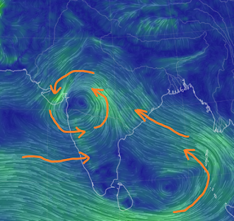
FAQ Reg:Gujarat Circulation
Weak circulation seen over Saurashtra region (see image on the right) is from the cyclonic circulation which was present near north konkan 2 days back.
This is bringing moisture from Arabian Sea and heavy unseasonal rains over parts of Saurashtra (Junagadh region).
Gujarat region of Ahmedabad/Gandhinagar, Vadodara, Bharuch may see some cloudiness with chance of light rain in some areas during this time.
Dry weather expected after 12th October with SW Monsoon withdrawal from south Gujarat regions.
8th October
Rainfall from fizzling BB14
Rained more than expected...Vagaries of the Weather ‥
This is October Rain..👇😧
Gujarat


MMR and nearby region rainfall till 8:30am on 8th October, 2022(in mm):
1. Grant Road:226
2. Dadar(Vag Salil):205
3. Masjid Bunder:184
4. Byculla:181
5. Mahalaxmi:177
6. Marine Lines:173
7. Dombivli:169
8. Kopar Khairane:141
9. Sion:140
10. Versova & Vikhroli:134
11. Chembur:128
12. Ghansoli:125
13. Bandra:120
14. Belapur:119
15. Airoli:115
16. Santacruz IMD & Matheran:114
17. Deonar(Vag Ronnie):113
18. Vashi:110
19. Andheri:109
20. Powai:108
21. Panvel:106
22. Thane:104
23. Ram Mandir:94
24. Mumbra & Kalyan:93
25. Mulund:89
26. Virar:87
27. Palghar:86
28. Dahisar & Colaba IMD:85
29. Mankhurd:82
30. Malvani:77
31. Bhayandar:67
32. Borivali:65
33. Kandivali:64
34. Vasai:57
35. Dahanu:55
Data Credits: MCGM, IMD & Vagarians
Compiled by: Vagarian Abhishek Apte
Weather scenario for Weekend 8th October to 13th October
Rainy weather for north and west India!
Rainfall likely in east Gujarat (Ahmedabad, Gandhinagar, Vadodara, Bharuch regions) and parts of south and east

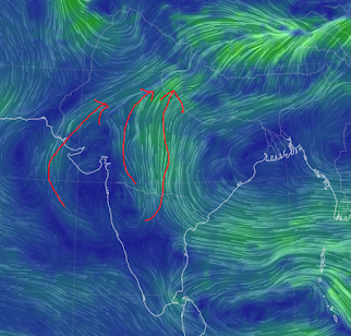
A cyclonic circulation seen at 850 hPa over north Maharashtra causing moisture inflow from Arabian Sea, resulting in rains and delaying SWM withdrawal.
850 hPa winds
7th October Evening 6pm.
The thundershowers in Mumbai today is not unusual or alarming.
As the movement of the low pressure system BB 14, moved across Central India, it has activated rainfall in Mumbai and Gujarat.

This resulted with an interaction with a Western Disturbance trough from North India. Hence the thunder.
This system activation was expected, and Monsoon Withdrawal date declaration held back ( see previous post).
Showers in South Mumbai and Suburbs
Figures from 2pm to 6pm Compiled by Vag Tejas
Cooper hosp 49mm in last 4 hrs
Versova pumping station 61mm
Jogeshwari rly station 47mm
Ram mandir 37mm
DN road municipal head office 68mm
Sobo higher than suburbs
Mumbai MMR, Pune and Nashik district can receive thunder showers ..chance of rain/thundershowers persists over the weekend.
Mumbai Monsoon can persist into next week
NASA scientists are studying the latest satellite imagery of the storm and analyzing the forces that made the storm so catastrophic.
Very Good Images and Explanation here. (Also on World Weather News Page)
Posted on 2nd October Evening:
Mumbai: The last 3 days of the Navratri celebrations...and how is the weather going to play along ?
Hold on Monsoon still lingering.
This week ( 3rd Monday to 6th Thursday), Mumbai will see partly cloudy skies. But a few moderate (and sharp intense) thundershowers are likely. Rainfall around 10-25 mms/day variation expected. Occurrence of the showers would be in localised in different areas of city. Possibility of an evening shower on Dussehra holds good.
Pune: also can see some light to moderate showers in the late afternoons. expected rainfall in parts of city around 5-10 mms.
For both cities, we hold on the further Forecast, as a dim chance of rain continuing into weekend holds good.
Marathwada & Vidharbh will get light to moderate rainfall this week 3rd onwards. Around 10 mms/day. Few places rain may exceed 20-30 mms/day from 5th Wednesday
Farmers are advised to cover the crops if already cut and removed for storage. As wet conditions may spoil the cut crops.
या आठवड्यात मराठवाडाआणि विदर्भ हलका ते मध्यम पाऊस पडेल. सुमारे 10 मिमी/दिवस. शेतकरी आधीच कापलेली आणि साठवणीसाठी काढलेली पिके झाकून ठेवू शकतात. ओल्या परिस्थितीमुळे कापलेली पिके खराब होऊ शकतात. काही ठिकाणी बुधवार 5 ऑक्टोबर पासून 20-30 मिमी/दिवस पेक्षा जास्त पाऊस असू शकतो.-----------------------------------------------------------------------------------------------------------------------------
BB-14 moving towards the UAC, and could merge as explained earlier.

But, its further movement after crossing the A.P./Odisha coast should be NW.
Interacting with W.D, there will be some rains in Central India, Bihar, U.P. Uttarakhand (East)and .Affecting upto Nepal..
We expect possibly some post Monsoon showers in Delhi this weekend.
Keeping in mind the above scenario, we hold on to the withdrawal line for a few more days.
18th July Rainfall in cms


