Wednesday, June 30, 2021

Maharashtra’s Top 15 Stations Seasonal Rainfall for June 2021


Amboli & Kitwade both from Maharashtra Ghat shares 1st spot to achieve 2K mark from entire western ghat section of India!


Maharashtra Rainfall Toppers from 01-06-2021 to ending till 8.30 am on 30-06-2021

=====================
in mms


1. Kitwade, Ajara - 2167

2. Amboli, Sawantwadi - 2032

3. Ambavali, Ratnagiri – 2019

4. Shirshi, Ratnagiri – 1840

5. Bharne, Ratnagiri - 1623

6. Patgaon, Bhudargad - 1590

7. Gaganbawada, Kolhapur – 1555

8. Dapoli, Ratnagiri – 1537

9. Khed, Ratnagiri – 1515

10. Dajipur, Radhanagari – 1509

11. Tulshi lake, Mumbai – 1505

12. Tamhini, Mulshi – 1500

13. Kulwandi, Ratnagiri - 1497

14. Vakavali, Ratnagiri – 1491

15. Sawantwadi, Sindhudurg - 1481


Khasi Hills, Meghalaya from NE India is Country wide Rain topper which is known for ‘King’ as is one of the wettest place on the Earth! 

Seasonal total from 1st to 30 June 2021 in mm

Mawsynram, Meghalaya 2597

Cherrapunji, Meghalaya 2547 

 Top 15 highest rainfall cities of Gujarat this June month 

1. Anand 468 mm

2. Surat city 412 mm 

3. Kaprada(Valsad) 390 mm

4. Jalalpore(Navsari) 379 mm

5. Pardi(Valsad) 370 mm

6. Navsari 370 mm

7. Khergam(Navsari) 365 mm

8. Gandevi(Navsari) 360 mm

9. Umerpada(Surat) 350 mm

10. Valsad 348 mm

11. Vapi 343 mm

12. Kamrej(Surat) 339 mm

13. Umergam(Valsad) 325 mm

14. Danta(Banaskhanta)312mm

15. Kheda 304 mm

Compiled by Vagarian Shitij ( Surat) 

From Vagarian Abhishek Apte: (below) 

Raigad district total rainfall(in mm) from (1st June-30th June,2021):-

.Shrivardhan:1407

2.Matheran:1255

3.Tala:1172

4.Mhasla:1143

5.Roha:1053

6.Murud:1040

7.Mangaon:1038

8.Poladpur:986

9.Sudhagad Pali:976

10.Panvel:916

11.Mahad:889

12.Karjat:832

13.Pen:802

14.Khalapur:776

15.Uran:685 

Ratnagiri district total rainfall(in mm) from(1st June-30th June,2021):-

.Wakwali:1379

2.Rajapur:1356

3.Harnai:1295

4.Dapoli:1259

5.Ratnagiri:1229

6.Guhagar:1224

7.Khed:1189

8.Lanja:1117

9.Sangameshwar:1087

10.Chiplun:1063

11.Mandangad:1038

Monday, June 28, 2021

Posted 28th Night

The 2 days thunder showers spell expected in Interior Maharashtra ( Sunday 27th & Monday 28th), after covering some parts of Marathwada an Vidharbh on Sunday, moved into Northern Maharashtra on Monday. 

Monday 28th Late evening Satellite/Radar image shows the details. 

Small patchy pop ups around Bhopal and South & West of Indore sand pop ups in a couple of spots in Gujarat seen. 


Earlier forecast holds good. . Till 2nd July

Rain decreasing in Interior Maharashtra and Gujarat

No major alerts.

Mumbai: Next from 29th - 2nd July. Partly cloudy⛅ with sunny periods. Some showers, maybe heavy, in parts of city. Humidity will be sticky around 75 %.

No alerts

Pune: Cloudy ⛅ with sunny spells. Few light showers scattered in parts of city. 

The Wait for Monsoon continues in NW and North India. Region heats up as the rains elude. 
Delhi remains hot with S'Jung at 40c.

Sunday, June 27, 2021

Sunday 27th Weather.. Pan India


Thunder Shower activities seen in Vidharbh and moderate thunder showers in parts of Marathwada  ( much needed) and Nasik Region. 

Hoping the weather persists on Monday also.. As we anticipated. 

Adjoining Telengana gets good thunder showers. 

Satellite images of Sunday Evening... From "Weather & Radar"


North, NW India waiting for proper rains. 

South and Eastern India not seeing much rainfall. 


Saturday, June 26, 2021

Posted 26th June  Night

Delhi, Haryana,Punjab and West Rajasthan will have to wait for  the  Monsoon for another 5 days at least.

Outlook for 27th - 1st July...

Forecast for next 4 days, 27th, 28th ,29th and 30th June:

Maharastra :Light to moderate rain with thunder expected in Vidarbha regions of Maharashtra. Some places can get heavy thunderstorms. 

Nagpur Region :Heavy thunder showers on Sunday and Monday. 

Parts of Madhya Maharashtra around Nashik can also get Thundershowers. Some convective rain likely around Western Ghats and adjoining leeward regions.

Light to Medium rains in Marathwada. 

Aurangabad District:  Partly cloudy with medium showers ,around 4 - 10 mms per day in some areas. More rains  needed seeing this field picture  from location in Aurangabad District. ( from local farmer)


Gujarat State not expected to get any meaningful rains. Except South coastal Surat and Valsad ( which may  receive light to medium showers),other parts of Gujarat will get no meaningful  rainfall, 

East M.P can also get light to moderate Thundershowers during this period.

Delhi : Strong warm Westerly Winds  will keep Delhi hot ( >40c) and possible of a Cb clouds developing due to heat convection. 

Mumbai : Periods of sunny weather, warm, humid and a few showers. In between showers will be humid. 

No alert or major increase in rainfall. Temperature  ranging between 33 - 27c ( Stuffy). Real feel Temperature  will be 37c.

Pune: partly cloudy with sunny periods. Not much meaningful rains with days around #

31c. Real feel 37c. Nights  around 21c.


Thursday, June 24, 2021

 Mumbai Lakes Storage 

  • 15.54%
    Combined live storage across all lakes compared to 10.00% same time last year. 224,894 million litres - Live storage as at 6 am 24 Jun 2021. [Annual requirement: 1,447,363 million litres, Total capacity: 1,778,000 million litres]
  • 59
    Number of days of supply left in all lakes combined (@ 3,800 million litres BMC supplies to city each day).

23rd June Rainfall Image M.P,Gujarat, Maharashtra.

Click on Image


Monday, June 21, 2021

 Posted 21st Night:

Major outlook for next 4 days is moderate rainfall in Odisha, West Bengal, NE States.

Some medium to nominal rainfall along West Coast and Southern Peninsula.

Scanty rainfall in all the other major regions.

(See Map in previous post.)

Outlook for some Regions/Cities next 4 days till 25th June:

Mumbai: Partly cloudy . sunny periods. Warm and humid, Temperature range between 34 - 26c, with real feel temperature around 37c. Few passing showers in between. 

Pune: Partly cloudy with light rains in parts. Warm in the day with temperature range between 31 - 21c.

Goa: Cloudy with occasional showers. 

Delhi Strong winds, but no rains possible

Kolkata: Few showers with slight increase in rainfall from 24th.

Click on Images


.


Sunday, June 20, 2021

Posted 20th Afternoon: 

Outlook 20th - 24th  June

With the Monsoon Axis running North again, subdued rainfall in the major parts of the Sub Continent.

Only Moderate rainfall along West Coast: Moderate rainfall in Chattisgarh and adjoining East M.P., Moderate to heavy in Odisha and parts of West Bengal. Moderate to heavy falls in NE States.

Rest of he region will get scanty rains.

But windy in the NW and western States and Interiors of Gujarat and Mah. strong West/South-Westerlies. (South of Axis).

Marathwada will get very scanty and sparse  rainfall . No meaningful rainfall, and getting hotter.

(मराठवाड्यात अत्यल्प आणि विरळ पाऊस पडेल. अर्थपूर्ण पाऊस पडत नाही, आणि अधिक गरम होतो.)


Saturday, June 19, 2021

 19th June afternoon

The monsoon axis has slid South in Central India. 

Thus advancing the South West Monsoon.. Now West Rajasthan still to get the Monsoon current.

But, no meaningful rains in Delhi next 3 - 4 days. This was explained earlier. 

As moving into Southern Coastal Sindh, 

Karachi will be cloudy with light rainfall next 2 days. 

Friday, June 18, 2021

 Outlook for the Weekend:19th/20th/21st

Mumbai: Warm, Humid  day and stuffy nights. Temperature range between 31c - 25c. Periods of sunshine with irregular showers, some with sharp intensity. 

No Alert for Mumbai.

Mumbai Lakes /Water Position:

  • 12.90%
    Combined live storage across all lakes compared to 11.57% same time last year. 186,718 million litres - Live storage as at 6 am 18 Jun 2021. [Annual requirement: 1,447,363 million litres, Total capacity: 1,778,000 million litres]
  • 49
    Number of days of supply left in all lakes combined (@ 3,800 million litres BMC supplies to city each day).
-----------------------------------------------------------------------------------
Goa: Occasional heavy to moderate showers . Around 30-50 mms /day.

Substantial Reduction in rainfall in South Coastal Gujarat.

-------------------------------------------------------------------------------

Rainfall around Mumbai as on 18th Morning (Last 24 hrs).

North Mumbai(including Dahanu):

1.Dahanu:219mm
2.Dahisar:151mm
3.Borivali West:107mm   4.Kandivali West:105mm
5.Andheri West:88mm   6.Santacruz IMD:83mm
7.Malvani:76mm   8.Ram Mandir:72mm
9.Vile Parle:68mm   10.Bandra:61mm
Dadar (Pvt Reading) 45 mms.

Thane district:
1.Kasarvadavali, Matheran:227mm
2.Bhayandar:222mm   3.Mumbra:213mm   4.Airoli:205mm
5.Chirak Nagar:204mm   6.Kopri:201mm
7.Manpada:199mm   8.Kalwa:182mm
9.Diva:169mm   10.Dombivli:150mm
11.Mira Road:152mm   12.Kalyan:125mm

Eastern suburbs and Navi Mumbai:
1.Rabale:207mm
2.Mulund East:193mm
3.Sanpada:170mm   4.Powai:167mm   5.Vashi:164mm
6.Ghansoli:163mm   7.Bhandup:160mm   8.Belapur:149mm
9.Kopar Khairane:136mm   10.Vikroli:131mm
11 Mankhurd:92mm   12.Deonar:91mm
13.Chembur:81mm   14.Sion:55mm

Thursday, June 17, 2021

Pop ups in Gujarat on 17th


Posted 17th June afternoon:

Monsoon Axis seems to be too much in the North, restricting the advance of the Monsoon.

Gujarat Outlook:

Some rainfall figures from South and North Mumbai Metro Region ending at 8:30am on 17/06/2021:-

South Mumbai:-

1.Malabar Hill:83mms

2.Dadar West(Pvt Vag Reading):65mms

3.Byculla Railway Station:58mms

4.Worli:57mms

5.CST Railway station:55mms

6.KEM Hospital:52mms


North Mumbai:

1.Santacruz IMD:31mms

2.Andheri West:25mms

3.Borivali West:21mms

4.Dahisar:20mms

5.Malvani:10mms

6.Ram Mandir:8mms


Wednesday, June 16, 2021

Today in the day (Wed 16th), from 8.30 am  - 8.30 pm rain recorded

Mumbai Colaba 100 mms, Scruz 25 mms. The imbalance trend continues. 


Posted Wednesday 16th 11.30 am

Rainfall recorded in last 24 hrs  between 11.30am Tuesday and 11 am Wednesday..

Compare South v/s North Mumbai: (24 hrs ended 11.30 am..Not 8.30 am)

South/Central Mumbai: Worli 128 mms, Colaba 100 mms, Malabar Hill 97 mms,  Haji Ali  62 mms, BMC Office  58 mms, 

V/S

North Mumbai Bhandup 9 mms, Goregaon 13 mms, Dindoshi  17mms, Mumbai A.P. 33 mms, Andheri 34 mms, 

From MCGM Site

Mumbai Circled in Image


Monday, June 14, 2021

Posted 14th Night-

As explained below, Heavy rainfall in Goa on 14th


Vagarian Atul Naik's PWS at Margao reading for same 12 hrs today 118 mms. 

And for South konkan, Vag. Abhishek compiled these rain amounts


Posted 14th June 1 pm IST:

The system BB4, is now over North Odisha/Jharkhand. expected to move W/NW, but not as a very strong system. 

New Delhi: Now, this will bring the rains upto Delhi in the next 2/3 days. But, the rains decrease in Delhi after the 17th...so, even with the axis running through the North (as seen in this map), and the rains mellowing down later...Can we announce the Monsoon  ?  Monsoon may advance technically and then weaken.


The axis will remain around Central India after 17th...

Outlook for 14th-16th:

Mumbai: For the next 3 days, Monday 14th thru Wednesday 16th. Warm and Humid...A few occasional showers or periods of rain with clear intervals.  Approximately 20-25 mms/day. A slight increase in rainfall on 17th possible.

Pune: Cloudy skies and humid. Light "Puneri" rains ( light drizzle to moderate rains) in parts of city. Days around 29c and ranging to a low of 22c.

Goa: Heavy rains, around > 250 mms on 14th/15th cumulative. Heavy showers on 16th also.

Heavy Rains in SouthKonkan, Goa and Coastal Karnatak.

Sunday, June 13, 2021

 Posted Sunday morning.. 

Estimate for Central India, East  India, Odisha and West Coast of India messed up... BB4 below expected strength, as we said it was too close to the coast. Prevailing SW Winds not getting the pull required. 


Rainfall on Saturday
Scruz 74 mms, Colaba 24 mms
Ratnagiri 150 mms


Saturday, June 12, 2021

Friday, June 11, 2021

Posted Friday 11th June afternoon:


The Upper air circulation (UAC) over North Bay of Bengali is now a low pressure area BB-4  over Northwestern Bay. May intensify till well marked low (WML) as it moves in a West-Northwest direction towards east MP.

Too near the coast to intensify further.

Under it's influence, increased rainfall expected over Vidarbha, Chattisgarh, Northern Telangana and also parts of Odisha and east MP. Monsoon advancing accordingly in these regions.

This will also result in strong westerlies being pulled from the Arabian Sea, increasing rainfall along West coast and Ghats. South Konkan, Goa and Karnataka coasts and adjoining Ghats to receive heavy rain over next 2/3 days from Saturday.

Hence increase in rains from Saturday 12th  in Mumbai.

---------------------------------------------------------------------------


Thursday, June 10, 2021

 Outlook for Weekend 11th/12th/13th..(Posted 10th Afternoon)

Mumbai:  Friday 11th will get fairly regular intermittent rain showers, some heavy. Saturday12th and Sunday will see increase in rain frequency and intensity with frequent  heavy falls and increase in rains overall.

But we see below the vast variations in the Mumbai Metropolitan Region in a day's rainfall...from 81 mms at Grant Road to 264 mms at Juhu. So, in short, we can expect an average rainfall (North to South ranging from 60-120 mms per day on 12th and 13th. Possibly, this spell will be more intense in southern and Central Mumbai.

No alarming situation as the rainfall on Saturday and Sunday will be almost half (per day) of the Wednesday's rain. 

Pune: Pune drizzles and light rains this weekend, with cool weather conditions. Later we see increase after Tuesday.

Vidharbh and Chatisgarh will get Heavy rains this weekend. Nagpur will get the Monsoon showers.

Gradual Monsoon advance into Gujarat:

Surat: Monsoon approaches into Surat gradually with normal rains. We see moderate rainfall in Surat ,7-15 mms per day for the weekend.

Bharuch will also get Monsoon advancing by weekend. Light to moderate rains there 5-10 mms per day this weekend.

---------------------------------------------------------------------------------------------------------------------------Some rainfall figures of Raigad district ending at 8:30am on 10/06/2021:-

1.Panvel:160mms

2.Matheran:122mms

3.Uran:111mms

4.Roha:97mms

5.Shrivardhan:87mms


Wednesday, June 09, 2021

Some rainfall figures in Mumbai Metro Region and nearby areas from 8:30am-8:30pm(12hrs) on 09/06/2021 are as follows:-

1.Juhu:257mms

2.Chembur Naka:244mms

3.Vikhroli:238mms

4.Vile Parle:228mms

5.Milan Subway:226mms

6.Santacruz IMD:222mms

7.Sion:220mms

8.Versova:202mms

9.Andheri:195mms

10.Koparkhairane:193mms

11.Mankhurd:191mms

12.Dadar West(Pvt Vagarian Reading):185mms

13.Manpada:181mms

14.Ram Mandir:180mms

15.Belapur:174mm

16.Powai:172mms

17.Mumbra:168mm

18.Malvani:164mms

19.Dahisar:136mms

20.Kandivali West:128mms

21.Colaba IMD:51mms


Data compiled by: Vagarian Abhishek Apte

Posted 9th June...Updated at 3.15 pm IST

Heavy rains for Mumbai today.. Thunder showers to lash today.. Crossing 150 mms Or more. 


Lesser frequency on 10th..only to increase from 11th, 

Monsoon keeps date with Mumbai..

Advances into Mumbai on 9th..also respected Vagaries date estimate. 

Wind Chart below...the rain figures ↓↓

Some rainfall figures in Mumbai Metro Region and nearby regions from 8:30am-8:30am(24hrs) on 09/06/2021 are as follows:-

.Belapur:163mms

2.Chembur:125mms

3.Worli:105mms 4.Malvani:104mms

5.Lok gram, Mankhurd:102mms 6.Breach Candy:100mms

7.Mumbra:97mms 8.Dahisar:95mms

9.Thane(Traffic Park), Diva:93mms 10.Kandivali West:93mms

11.Borivali West, Byculla:91mms 12.Bhandup:82mms

13.Dadar West(Vagarian Pvt Reading):81mms

14.GTB Railway Station:78mms 15.Colaba IMD:77mms

16.Mohane, Ram Mandir:75mms 17.Juhu:71mms

18.Bandra:70mms 19.Andheri:63mms

20.Santacruz IMD:60mms 21.Matheran:39mms


Tuesday, June 08, 2021

Monsoon advancing into Mumbai on Schedule..9th

Some rainfall figures in Mumbai Metro Region and nearby areas from 8:30am-8:30pm on 08/06/2021 are as follows:-

1.Malvani:90mms

2.Borivali West:76mms

3.Kandivali West:73mms

4.Dahisar:71mms

5.Chembur, Thane(Traffic Park):52mms

6.Colaba:38mms

7.Juhu:24mms

8.Dadar West(Vag Pvt Reading):23mms

9.Santacruz IMD:20mms

10.Ram Mandir:18mms

11.Andheri:19mms

Data compiled by: Vagarian Abhishek Apte

 Posted  8th June 3.30 pm IST

Pre Monsoon showers in Mumbai on 8th Morning..With thunder.

Some Mumbai city Area Rainfall till 3 pm on 8th Tuesday.

Malwani 66 mms, Dahisar 59 mms, Chincholi 46 mms, Andheri  38 mms , Colaba Stn  30 mms, Versova 19 mms, Ram Mandir 17.5 mms, Vagaries Club 14 mms, Haji Ali 11 mms Dadar pvt 10 mms.

Mumbai: with a few Thunder Showers on Tuesday, rainfall to gradually increase from Wednesday 9th..with the South West Monsoon advancing into Mumbai on 9th June.

9th/10th/11th will see intermittently heavy and regular showers.. Around 40-50 mm/Day  expected for Mumbai  on Wednesday and Thursday with increase in rain on Friday Heavy rains for the weekend expected.

Mumbai Water Storage Position as on 7th June.

  • 13.22%
    Combined live storage across all lakes compared to 14.72% same time last year. 191,359 million litres - Live storage as at 6 am 06 Jun 2021. [Annual requirement: 1,447,363 million litres, Total capacity: 1,778,000 million litres]
  • 50
    Number of days of supply left in all lakes combined (@ 3,800 million litres BMC supplies to city each day).

Rainfall expected to gradually increase from tomorrow,9th, along Konkan, Goa and coastal Karnataka. Offshore trough likely to form from south Gujarat till Karnataka coast, which will give moderate rain with heavy in some parts. SWM onset likely for Mumbai and Pune by 9th June.

Marathwada ( Aurangabad) will have to wait for the proper Monsoon rains till 13th at least. Till then few showers, not ready for sowing seeds.

मराठवाड्यात(औरंगाबाद)किमान 13 पर्यंत किमान मान्सून पावसासाठी थांबावे लागेल. तोपर्यंत काही शो, बियाणे पेरण्यासाठी तयार नाहीत.

Aurangabad Rainfall Details:

A low pressure area likely to form over North Bay by 11th/12th June, which can enhance the monsoon rains further along west coast and also cause the Bay branch of SWM to move inland across West Bengal and Odisha.

Matter Contribution from Vagarian Shreyas .


Monday, June 07, 2021

 Posted 7th Evening

Heavy Nor'Westers... Today's lmage


Pic by Vagarian Santosh (Kolkata) 

Dum Dum 40 mms in 9 hrs today. 
Bbsr  30 mms


Video sent by Vagarian Mitan (taken by Soham). 

Sunday, June 06, 2021

 Posted 6th June 12.30 pm IST

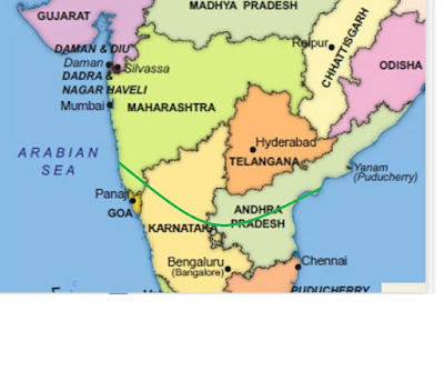
South West Monsoon Enters Goa and South Konkan...6th June.

Now runs from south Konkan thru south Interior Karnataka, south A.P...


With the Upper air circulation (UAC) now restricted to upper levels, and soon move away, the intensity of Thundershowers will reduce over Madhya Maharashtra from Monday. 


Westerly winds expected to strengthen gradually over North Konkan with the speed and depth increasing around middle of the week (9th/10th). 

This is when [ 9th/10th] monsoon arrival expected for parts of North Konkan, Mumbai and Pune. 

Similar advance into South Gujarat Coastline (Valsad/Surat Districts) on 9th/10th.Bharuch may see Monsoon advance around 11th.

Meanwhile, SWM can enter and commence in the NE States in next 2 days.

Nashik and North Maharashtra may get Thundershowers for another 2-3 days. 
[ मराठवाडा / औरंगाबाद - रविवारी हलकी ते मध्यम गडगडाटी वादळ. सोमवार ते शुक्रवार 11 जूनपर्यंत पावसाचे प्रमाण कमी. 15  जूननंतरच योग्य पावसाळा अपेक्षित आहे.
शनिवार 12 पर्यंत पेरणीची शिफारस करणार नाही, कारण तोपर्यंत कमी पाऊस पडण्याची शक्यता आहे. शनिवार 12 तारखेला बियाणे पेरणीच्या कामाचा आढावा घेता येईल. (ही वैयक्तिक दृश्ये आहेत आणि कोणताही शेतकरी स्वत: चा निर्णय घेऊ शकतो.)

नागपूर आणि विदर्भ प्रदेश - २- 2-3 दिवस गडगडाटी वादळ. आम्ही 13 जूनच्या सुमारास उपसागरात एक यंत्रणा वर्तविल्यामुळे पुढील आठवड्यात मान्सून वाढू शकतो.]

Marathwada/Aurangabad - Light to moderate Thundershowers on Sunday. Decrease in rainfall from Monday till Friday 11th June. Proper Monsoon expected only after 15th June.
Would not recommend sowing till Saturday 12th, as low rainfall is expected till then. Starting of seeds sowing can be reviewed on Saturday 12th. (These are personal views and any farmer may take his own decision.)

Nagpur and Vidarbha region - Thundershowers for 2-3 days. Monsoon possibly can advance next week as we forecast a system in the Bay around 13th June.


Saturday, June 05, 2021

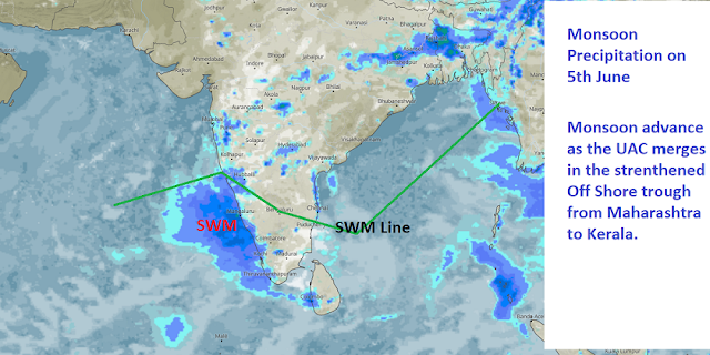
South West Monsoon Advances as a Moderate current into Kerala, South Interior and Coastal Karnataka.

Posted 5th June 2 pm IST:

South West Monsoon Advances as a Moderate current into Kerala and Coastal & South Interior Karnataka. 

Will remain as a moderate to weak currently.

Further advance also as a moderate current into Goa and South Konkan around 7th/8th June. 
Mumbai/Pune arrival  on the estimated schedule around 10th/11th June.

South Gujarat coastal advance of Monsoon around 12th June. Good moderate showers in Surat and Valsad from 9th/10th June.

Kolkata will be very hot now from Sunday thru Wednesday, shooting to >40c.. For Kolkata, Monsoon will be in-waiting, till we get a good system in the Bay. Will move into NE States initially.

Monsoon Advanced As per Criteria :


Friday, June 04, 2021

We see the UAC fizzling out today. 

Now, finally SWM will get a chance to advance in Kerala

Meanwhile...UAC off West coast continues its Pre Monsoon "duties".

Heavy pre-monsoon thundershowers lashed parts of Maharashtra on 04/06/2021..Some rainfall figures with drop in temperatures from maximum temperatures after rainfall till 8:30pm details are as follows:

Pune district:-

1.Pawana Dam:58mms, 2.Ghod Dam:49mms

3.Daund:47mms(Temperature dropped to 21.9c at 5pm from 34.4c at 2pm)

4.Bibwewadi:43mms(Pvt Vag reading)

5.Rajgurunagar:41mms(Temperature dropped to 20.6c at 4pm from 33.3c max)

6.Katraj tunnel:35mms, 7.Waki:34mms

8.Saswad:31mms,9.Andhra Dam:28mms

10.Kasarsai Dam:27mms

11.Loni Kalbhor:25mms(Temperature dropped to 19.8c at 6:30pm from 31.9c max)

12.Morgaon:19mms

13.Talegaon:15mms(Temperature dropped to 19.6c at 4:30pm from 33.8c max)

14.Yerawada:15mms

15.Magarpatta:10mms(Temperature dropped to 22.2c at 5:45pm from 33.9c max)

16.Shivajinagar IMD:6mm(Temperature dropped to 22.2c at 5:30pm from 32.8c max)

Satara district:-

1.Bamnoli:64mms, 2.Pratapgad:50mms

3.Banganga Dam:32mms, 4.Apshinge:20mms

5.Kati:15mms, 6.Nagthane:12mms

7.Mahabaleshwar:11mms(Temperature dropped to 18.1c at 6:30pm from 24.5c max)

8.Phaltan:9mm

Solapur district:-

Siddhewadi:78mms, Solapur:18mms

Data compiled by: Vagarian Abhishek Apte

Forecasted East rough  Let's look into the 3rd week of March ( 17th - 21st). Mumbai : Hot weather likely for Mumbai region this week, ty...