31st. October.

Vag.Vineet Kumar: Once again another example, Elnino not behaving like Elnino
31st. October.
Vag.Vineet Kumar: Once again another example, Elnino not behaving like Elnino
What is "Heat Dome "?Explained in Weather Knowledge Page-50
29th October Posting:
Mumbai Special
Mumbai is now seeing the brunt of the infamous Mumbai "post monsoon October heat". On 22nd October, Mumbai's day time temperature recorded was 37.4°c, the months highest this year. From 16th October this year, Mumbai has been hot at over 35c everyday. Last few days, we are seeing the days hotter than the normal average.

However, the highest ever recorded in October is 38.6°c 0n 17th October 2015.
As the Monsoon Withdraws, the South Westerly winds (Monsoon winds) immediately change direction, and become hot inland East winds. As the winds are easterly from the land, the cooler sea breeze typical of Mumbai, is restricted. Hence the day gets warmer.
Seeing the present and forthcoming weather expected changes. Mumbai can expect the weather to take a nip in the air after 10th November.
For Mumbai, currently the temperature day night range is 36 -22°c. Next few days can expect the nights to remain around 21-23•range at night. For Mumbai, below 20°c is a nip. So we can expect it to "chill" below 20°c around the Divali days.
Since the monsoon bid the city "good Bye", the pollution level sand the air quality has been technically termed as "poor", that is the Air Quality Index, ( AQI -measured taking into consideration all the polluting factors) is around 170-200. This is bound to happen, seasonally, as the strong Monsoon winds are no more blowing off the pollutants, and thus the stationary trapped air, accumulates the smog for several days. Lately, last few days, with the winds gearing up, we see the AQI levels dropping slightly.

Weather forecast from Saturday 28th to Tuesday 31st October:
Mumbai:
*Hot daytime weather 😓to continue due to easterly winds, with max temperature around 36C. *Nights/early mornings will be slightly pleasant around 21/22C.
*The nip may be short lived.Sunday onwards could rise to around 24-25C.
Interior Konkan/Thane district will see cooler nights/early mornings by around 2-4C compared to Mumbai (more cooler towards Ghats).
Pune:
*Warm days with max temperature around 32-33C.
*Nights will be pleasant around 14/15C.
*Outskirts can be cooler to around 13-14C. Some rise in night temperature is possible from Sunday.
Coolest regions in Maharashtra (apart from Deccan plateau in Pune/Nashik) will be parts of Jalgaon, Ahmednagar, Ch. Sambhajinagar and Buldhana districts, with minimum temperatures around 13C.
There is a chance of some clouding and light rain/thundershowers in parts of Kolhapur/Sindhudurg districts and Goa region on Tuesday 31st October. ( Reason for this explained below)
After the fizxling out of the twin cyclones Tej and Hamoon on either side of the Indian mainland, the northeast monsoon, now looks set to become active over Southern India.
Tamil Nadu and Kerala for the next four days (Oct 28-31) can expect thundershowers. These conditions are also likely to spill over to Coastal and South Interior Karnataka on Sunday and Monday (Oct 29-30).
Interior regions of south peninsula (Bangalore/Mysore/Karnataka Ghats, interior Tamil Nadu and Kerala) can see thundershowers. Coastal Tamil Nadu to start getting some showers as easterlies of NEM strengthen.
Gujarat: Overall hot weather during the day and slightly pleasant nights. Not much winter chill is expected anytime soon. Most areas (Ahmedabad, Vadodara, Surat, Bharuch) will see max temperatures of around 36C and min temperatures of around 20C. Rajkot region and Kutch can be hotter around 37-38C.
27th October:
Analysis of Much Discussed Mumbai Air Quality...
.png)
.png)
Mumbai has the world's largest slum area. A survey found that fuel used for domestic uses in the slums of Mumbai contributed about 27% to its pollution levels. Industrial and power plant emissions account for about 36% of the total pollution, accompanied by biofuels.
.png)
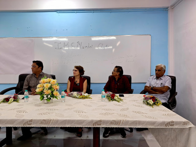
An interesting talk by Dr. Elana Surovyatkina, Potsdam Institute of Climate Impact Research, Germany, was organised by IMS and RMC Mumbai at RMC Colaba on 26th October.
Vagaries was honoured by kind invitation.
A very interesting talk/discussion on Indian Monsoon Onset.
We thank IMS and RMC for including us.
We thank Shri S.Kamble, Shri Sikandar, Ms Sushma Nair,Ms. Nitha and RMC scientists for the kind courtesy and lunch.


As per JTWC, Cyclone Hamoon rapidly intensified from 30knots to 70knots in last 24hrs (increase in windspeed of 40knots in 24hrs). This cyclone has undergone rapid intensification owing to strong poleward ouflow, upper level divergence due to presence of an upper level trough.
In early morning today, this cyclone has developed a strong eyewall.

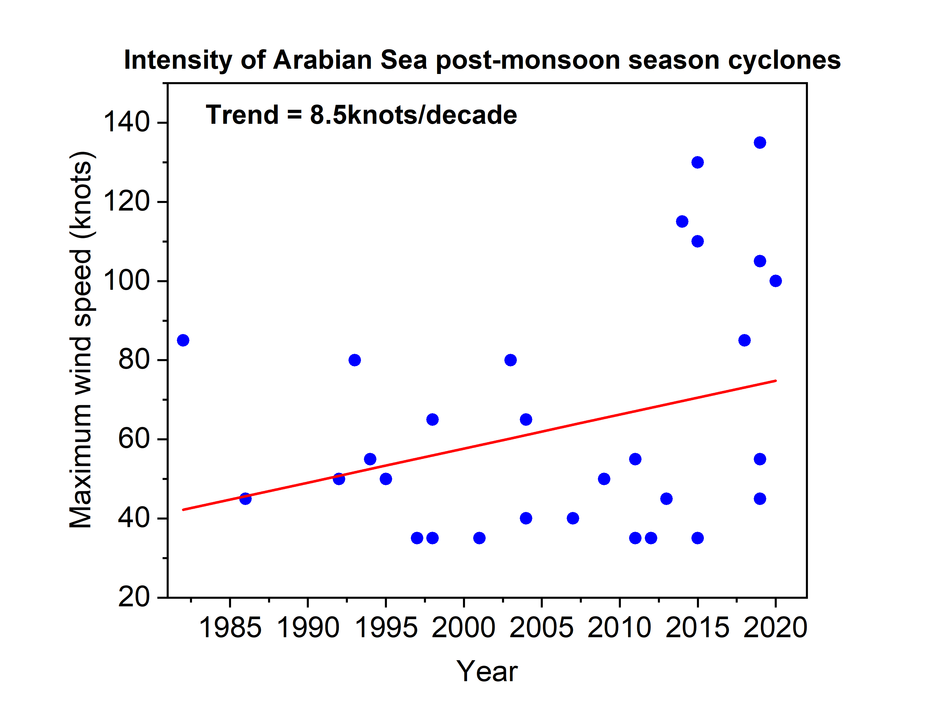
With a windspeed of 110 knots, CycloneTej is jointly the 4th strongest post-monsoon season cyclone in the Arabian Sea for the period 1982-2023.
Top 5 strongest cyclones in this season:
1. Kyarr: 135 knots
2. Chapala: 130 knots
3. Nilofar: 115 knots
4. Megh & Tej: 110 knots
Data: JTWC
This cyclone intensified from 55 knots (Tropical storm) to 105 knots (Category 3) in just 12 hours. This is jointly the most intense 12hrs rapid intensification by an Arabian Sea post-monsoon season cyclone. Data: JTWC


The frequency of cyclones (TC) during the post-monsoon season (Oct-Dec) in the Arabian Sea is increasing at the rate of 0.2/decade.
During the period 1982-2001: 1 cyclone use to form in 2 year.
Whereas, during the period 2002-2022: 1 cyclone form every year. Data: JTWC
The attached graph shows a rapid rising trend in the frequency of cyclones in this basin during the post-monsoon season for the period 1982-2022.

As the cyclone is going to form in the Arabian Sea, let's have a look at the intensity of cyclones in this basin in the post-monsoon season during last 40 years (1982-2021).
20th Afternoon status👇

19th October
The Arabian Sea "Cyclone", currently 1000 kms West of Kochi, is moving away from the Indian Coast..Posing "NO THREAT TO WEST COAST"👇

Likely to reach Salalah in Oman. Sea Surface temperatures near the Yemen coast are cooler, and could weaken the storm in the last leg.
-------------------------------------------------------------------------------------------
In a sudden and swift announcement, IMD has announced withdrawal the South West Monsoon from the entire country.
Vagaries anticipates the "total" withdrawal after complete reversal of Jet Stream winds in next 24-36 hrs.


Details on the North East Monsoon:
The Northeast Monsoon, also known as the retreating monsoon, is a weather phenomenon that brings rainfall to the southern states of India, particularly the coastal regions of Tamil Nadu, Andhra Pradesh, and parts of Kerala which typically occurs from October to December.
This monsoon is characterized by winds that blow from the northeast, carrying moisture from the Bay of Bengal, and causing rainfall in these regions. It is an important source of water for agriculture in the southern part of India.
SWM onset is well defined, and follows a well coursed out Northward progress. And can be discerned with reasonable accuracy on charts.
For the NEM, it is not so.
In fact, on many occasions, there is no clear indication between the widhrawing SWM and setting NEM. Often one tends to merge into another.
So, setting a date for the commencement of NEM is difficult, and sometimes not possible.
The Northeast Monsoon can give rise to various weather systems and features. Some of the common systems associated with the Northeast Monsoon include:
*The SWM has its origin, its "Power House", is at the Mascrene Highs off Madagascar. The NEM has its origin round a large anti-cyclone over Siberia.
*The Upper winds during the NEM across the Bay are in a clockwise direction.That is an anti-cyclone is formed. At a level of 500 mb, the centre of the anticyclone shifts to central Burma region.
*The Upper Air temperatures show a Northward gradient in the NEM.Near 10N it is normally warmest, and dropping by 8c at 30N.
*Jet streams at 200 hpa are common to both the monsoons.
In the SWM, the Tropical Easterly Jet stream dominates the Peninsula, while the Sub-tropical Westerly Jet Stream is the feature of the NEM.
*The normal Sea Level Pressure during the NEM is a large system of low pressure over the Central Bay. It can extend into the Indian Peninsula as a trough. Towards the end of November, there is a shift southwards of this extended low.
*The general variations and fluctuations in intensity of this low pressure, governs the rainfall. When the trough is well defined, and the low is well marked, rainfall over the southern peninsula is good.
*During the NEM, an occasional burst of cold air from the Siberian High develops a low pressure sysytems over the Equatorial regions of the South China Seas. These systems move slowly westwards thru Sarawak/Eastern Malaysia coast, and remnants of these cross over into the Bay and form depressions.
*Troughs and Convergence Zones**: Troughs and convergence zones can develop along the coast of southern India during the Northeast Monsoon. These areas of low pressure and wind convergence are favorable for sustained rainfall.
*Divergence over the Ocean: As the Northeasterly winds meet the warmer waters of the Bay of Bengal and the Arabian Sea, they can lead to air rising and divergence, which can result in the development of low-pressure areas and weather systems that bring rainfall to these coastal regions.
*Most of the NEM rains depend on depressions and cyclones from the Bay towards the East Coast of India.
Onset of Monsoon**: The onset of the Northeast Monsoon is usually marked by the arrival of the monsoon winds. Meteorological departments monitor wind patterns and rainfall to officially declare the onset of the monsoon season.

The movement of the ITCZ away from the Indian subcontinent during the Northeast Monsoon season is one of the factors that contributes to the dry and cool weather experienced in the southern and southeastern parts of India during this time. As a result, the ITCZ's position is inversely related to the distribution of rainfall in India, with northern regions receiving rainfall during the summer monsoon, and southern regions experiencing drier conditions during the Northeast Monsoon.
The Tibetan High, also known as the Siberian/Tibetan Plateau High, is a significant weather feature in Asia. It plays a role in influencing weather patterns not only during the Northeast Monsoon but throughout the year.

During the Northeast Monsoon season, the Tibetan High often has an indirect impact on the weather in South Asia, including India. Here's how it can be related to the Northeast Monsoon:
1. Wind Flow*: The Tibetan High can influence the wind patterns over the Indian subcontinent. During the Northeast Monsoon, the high-pressure system over the Tibetan Plateau can cause a pressure gradient that results in the flow of cool and dry air from the north/northeast towards the Indian subcontinent. This cool and dry air can interact with the warmer, moist air from the Bay of Bengal, contributing to rainfall in parts of southern India.
2. *Rainfall Patterns**: While the Tibetan High doesn't directly cause rainfall, its influence on the wind patterns can lead to the convergence of air masses over India. This convergence can be a factor in the development of weather systems and precipitation, including the Northeast Monsoon.
The Tibetan High, also known as the Tibetan Plateau High, is a significant weather feature in Asia. It plays a role in influencing weather patterns not only during the Northeast Monsoon but throughout the year.
It's important to note that the Tibetan High is just one of several factors that influence the Northeast Monsoon. Local conditions, such as sea surface temperatures, the presence of low-pressure areas over the Bay of Bengal, and interactions with other weather systems, also play a significant role in determining the behavior and intensity of the Northeast Monsoon in any given year.
During the Northeast Monsoon season, the Tibetan High often has an indirect impact on the weather in South Asia, including India. Here's how it can be related to the Northeast Monsoon.
It's important to note that the behavior and intensity of the Northeast Monsoon can vary from year to year, and meteorological agencies closely monitor these systems to provide accurate weather forecasts and warnings.
Mumbai Smog...conditions due to " Air Inversion"
This is when a layer of cooler air is trapped near the ground by a layer of warm air above the surface. When the air cannot rise, pollution accumulates near the ground, leading to higher pollutant concentrations
The warm air above cooler air acts like a lid, suppressing vertical mixing and trapping the cooler air at the surface. As pollutants from vehicles, fireplaces, and industry are emitted into the air, the inversion traps these pollutants near the ground, leading to poor air quality.
----------------------------
Posted 17th Afternoon:
The low in the Arabian Sea is now strengthening.

Track will be Northwest wards towards Oman.
Another formation in the Bay is showing formation in a few days ( from 17th)...and may also strengthen to head towards Bangladesh/ Myanmar coast.
The South West Monsoon will in all likelihood withdraw from the country by around 23rd-25th October.
Simultaneously North East Monsoon can set in around 23rd-25th.
Posted 16th Afternoon...Mentioned W.D.Cloud Height..50000 feet !

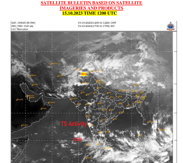
Posted 15th Night:
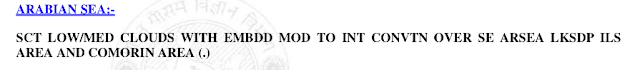
The formation, the initial nascent stage, of a new Low (AS 4) has formed in the Arabian Sea...

Pune: Hot at 34c and partly cloudy. Light drizzles in some areas.
Goa: Some Thunder showers on 16th/17th, due to the development clouds shown in image.
W.D. moving West into Northern India plains and Hills. good rainfall expected in hills with snow. Plains of Punjab, Haryana, West U.P, Rajasthan and North M.P. will get showers, bringing a fall in temperatures.
Research on Arabian Sea Cyclones by Vag.Shitij Jain.
I have conducted a research and have found that post monsoon months i.e. in October and November, the cyclones/depressions crossing Gujarat from Arabian sea have decreased considerably as compared with 100 years ago.
When compared to late 19th century period, from 1892 year to 1916 year 13 cyclones/depressions formed in Arabian sea in Oct & Nov month out of which 4 cyclones crossed Gujarat. This works out to 31%.
From 1936 to 1960 20 systems formed out of which 8 systems made landfall over Gujarat/konkan which comes to whopping 40%!!!!! And just 2 cyclones managed to move to Oman rest all died in sea itself!
But in recent years from 1998 to 2022, 31 cyclones/depressions have formed in Arabian sea out of which 5 systems have managed to made landfall into Gujarat that comes to only 16%.
First major WD for north India in this winter season
Posted 12th Evening:
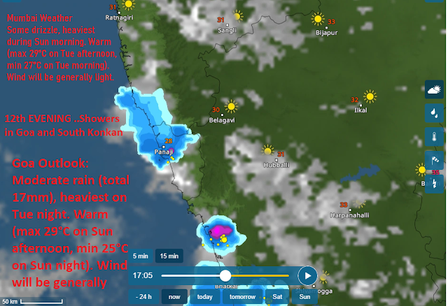
Weather forecast for Weekend till Tuesday 17th October:
The South West Monsoon winds have changed directions, but, with the Easterlies starting, we may see a confluence of East-West winds, Line of wind-discontinuity likely to develop near Western Ghats, with sea breeze providing the moisture. meaning👇
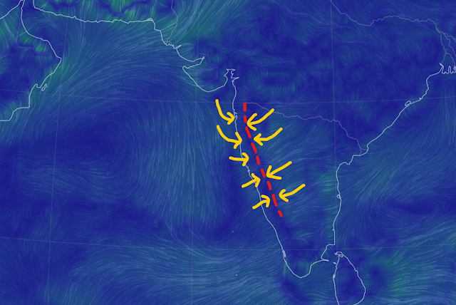
As explained in our forecast on 7th October, parts of South Konkan and South Madhya Maharashtra may get some light rain/thundershowers over next 4-5 days.
Districts such as Kolhapur, Satara, Sindhudurg and Ratnagiri have the most chance of seeing some showers.
Parts of Pune, Lonavala, Mahabaleshwar and Nashik districts near the Western Ghats may see some afternoon/evening cloudiness with a chance of light rain.
Few places in Raigad ( Panvel, Karjat, Matheran) district could also see some drizzle/light shower during 14th-15th October.
Maybe some chance of post monsoon rain for Mumbai MMR, a few pockets could get some drizzle on Saturday/Sunday.
Interior konkan can see a higher maximum temperature of around 35-36°C and a slightly lower minimum temperature of around 23°C.
Pune city: Hot daytime weather of around 34°C, and nights around 19°C. Afternoon/evening may see some clouds, with a small chance of post monsoon drizzle/light rain in some areas.
Daytime will be hot in most of Maharashtra with max temperatures between 33-36°C.
Goa: Hot and humid weather with chance of some rain/thundershowers in the afternoon/evening.
North India in for a rainy period from 14th-17th October - unusual for this time of the year!!
Two back to back Western Disturbances (WDs) likely to affect northern parts of India from 14th October.
The second WD is likely to be much stronger. This rainy spell will cover not only the hills but also the plains, including Rajasthan, Punjab, Haryana, and even Delhi NCR and Uttar Pradesh. The heaviest rain is expected on the 16th and 17th October.
The Cricket World Cup Match in Dharamshala on 17th October may get affected by rain.
Dr. Vineet's Page Updated
8th October Evening..
Air Quality 👇

Where is Mumbai in World Ranking (Air Quality) ?

Pune: Some clouding, higher altitude, will result in a day temperature of 33c. But as we have some moisture around, nights expected around 19c.
Air Quality getting bad gradually in Pune..👇

Delhi for Comparison.👇

AQI here not as bad as Eastern U.S.😑
-----------------------------------------------------------------------------------------------------------------------
The South West Monsoon withdrawal process continues South of Maharashtra...850 Chart 👇
But next 3/4 days, Coastal Karnataka and Kerala can expect some increase in rainfall activity.

Posted 5th October
Vagaries' calculated date ..5th October..
Monsoon over in Mumbai...
Monsoon rains have withdrawn with such dry conditions from Gujarat, Madhya Pradesh and Maharashtra. 👇

The low pressure system over West Bengal will also weaken and rain will gradually stop in the next 48 hours. Large parts of India will get drier in the next one week.
Nights getting cooler in Interior Maharashtra..On 5th morning Sambhajinagar recorded 18.6°, Jalgaon 19.0° and Pune 19.3°.
Dry air intrusion brought by eastward extending subtropical ridge at mid levels lead to clear skies and LW radiation emission resulting in temp. drop.
Rajasthan also starts getting cooler with Sikar recording 14.5°.
Credit to Vag. Gokul for contributing.
Final Figures for Mumbai Monsoon 2023
Santacruz 2978 mm ( 117.2 ")
Colaba 2398 mms ( 94.5")
Ending on good note with Lakes at 99.3% full...enough storage till next monsoon.
Monsoon to completely withdraw by 4th October..4 days before official date of 8th.
2nd & 3rd October: Light drizzles in some parts.
4th October:Almost dry as Monsoon over. Sunny and hotter.
Compare with Maharashtra Coast

.
This monsoon had an August that saw a rainfall deficit of 36%!! A good September that gave us 13% above normal rainfall made up the August deficit somewhat but we still ended this monsoon with one of the 30 lowest monsoon rainfall since 1901. As seen in the figure below the red line shows the present monsoon status and where it lies on the monsoon distribution curve since 1901. A total of 27 years have seen lower monsoon rainfall than 2023 since 1901. 1972 with 697.4 mm saw the lowest monsoon rainfall in this period.
In this century 2018 (802.7 mm), 2015 (765.8 mm), 2014 (781.7 mm), 2009 (698.2 mm), 2004 (774.2 mm), 2002 (737.3 mm) were years with monsoon rainfall lower than 2023.
X-axis represents years with monsoon rainfall starting from lowest of 697.4mm in 1972 (extreme left) to 1124.2 mm in 1917 (extreme right).

18th July Rainfall in cms


