| RAINFALL FOR THE PERIOD 1-3-2020 TO 31-5-2020 | ||||
| ( Districts with rainfall in excess of 500 mm) | ||||
| DISTRICT | STATE | ACTUAL | NORMAL | DIFF +/- |
| EAST KHASI HILLS | MEGHALAYA | 1867.5 | 1180.9 | 58% |
| JAINTIA HILLS | MEGHALAYA | 1829.5 | 1044.6 | 75% |
| WEST KHASI HILLS | MEGHALAYA | 1356.1 | 634.4 | 114% |
| EAST GARO HILLS | MEGHALAYA | 1291.8 | 659.8 | 96% |
| GOALPARA | ASSAM | 1117.5 | 652.4 | 71% |
| LOWER DIBANG VALLEY | ARUNACHAL PRADESH | 997.5 | 1209.9 | -18% |
| CHIRANG | ASSAM | 937.8 | 754.8 | 24% |
| UPPER SIANG | ARUNACHAL PRADESH | 924.9 | 1005.0 | -8% |
| WEST GARO HILLS | MEGHALAYA | 903.2 | 636.0 | 42% |
| KOKRAJHAR | ASSAM | 887.3 | 740.4 | 20% |
| NORTH SIKKIM | SIKKIM | 873.7 | 668.0 | 31% |
| DHUBRI | ASSAM | 870.5 | 665.6 | 31% |
| EAST SIANG | ARUNACHAL PRADESH | 869.2 | 811.5 | 7% |
| PATTANAMITTIA | KERALA | 856.0 | 495.3 | 73% |
| DHEMAJI | ASSAM | 821.5 | 544.5 | 51% |
| NALBARI | ASSAM | 757.9 | 605.3 | 25% |
| BAKSA | ASSAM | 753.5 | 593.8 | 27% |
| BARPETA | ASSAM | 732.4 | 642.5 | 14% |
| RI BHOI | MEGHALAYA | 699.2 | 437.4 | 60% |
| ANJAW | ARUNACHAL PRADESH | 689.6 | 1027.4 | -33% |
| SOUTH GARO HILLS | MEGHALAYA | 679.8 | 636.0 | 7% |
| BONGAIGAON | ASSAM | 664.4 | 674.0 | -1% |
| DHALAI | TRIPURA | 654.3 | 698.4 | -6% |
| KOTTYAM | KERALA | 652.5 | 433.2 | 51% |
| NORTH TRIPURA | TRIPURA | 642.5 | 784.1 | -18% |
| KAMRUP RURAL | ASSAM | 603.3 | 516.0 | 17% |
| KAMRUP METRO | ASSAM | 602.8 | 404.5 | 49% |
| THIRUVANANTHPURAM | KERALA | 592.2 | 363.9 | 63% |
| JALPAIGURI | WEST BENGAL | 581.7 | 547.1 | 6% |
| PAPUM-PARE | ARUNACHAL PRADESH | 573.2 | 798.2 | -28% |
| WEST KAMENG | ARUNACHAL PRADESH | 556.9 | 438.5 | 27% |
| NORTH 24 PRAGANA | WEST BENGAL | 548.2 | 230.5 | 138% |
| WEST SIANG | ARUNACHAL PRADESH | 528.7 | 525.2 | 1% |
| RAMBAN | JAMMU & KASHMIR | 521.3 | 451.9 | 15% |
| ALAPPUZHA | KERALA | 517.8 | 451.7 | 15% |
| KOCHBIHAR | WEST BENGAL | 515.5 | 513.3 | 0% |
| KOLLAM | KERALA | 514.2 | 455.2 | 13% |
| SOUTH TRIPURA | TRIPURA | 508.0 | 582.6 | -13% |
| KARIMGANJ | ASSAM | 506.9 | 992.7 | -49% |
| CACHAR | ASSAM | 505.7 | 846.1 | -40% |
| SOURCE | IMD | |||
Sunday, May 31, 2020
Posted 31st May 12 Noon:
AS-1 forms in the Arabian Sea at 10.6N and 72 E..1007 mb estimated pressure, about 440 kms West of Kochi.
Fast development of Divergence seen at 200 levels. Favourable SST and Low wind shears at lower levels will help in fast intensification of the system.
Likely now to intensify to Depression and Deep Depression by 2nd June..and track along the coast.
System , under upper air influence, likely to cross land on the Mah/Gujarat coastal border by 3rd June..
Heavy rains in Kerala and Coastal Karnatak on 31st/1st June and moving up the coast to Goa, South Kokan by 3rd June, finally system turning NE towards land by 3rd June , with very heavy rains in North Kokan and South Gujarat coast.
Mumbai: Cloudy and light pre monsoon rains on Monday. Days cooling down by 4/5 degrees next week...
Tuesday increase in rains and windy.
Wednesday, rather heavy thunder showers ( 75-95 mms) and very windy from the E/SE. Around 50-70 kmph in phases. Rainy days .
Pune: Pre Monsoon showers commence on Monday and increase on Tuesday. Wednesday heavy rains , upto 50 mms, with a cool day with maximum around 25c. Decrease in rainfall from Thursday.
Goa: Rather heavy rains from Monday thru Wednesday. Expecting good amounts on Tuesday with day below 30c.
Surat: Moderate to heavy showers likely in Surat from Tuesday thru Friday..yes, thru the week. Initially on Tuesday /Wed we may see upto 35 mms/day.
But Valsad, being nearer the crossing path, may see heavier rains upto 60 mms on Wednesday.
Saturday, May 30, 2020
One of the conditions of the onset over Kerla is depth of westerlies up to 600hpa. Presently westerlies are confined up to 850 hpa. Disorganized due to UAC. So conditions are not ripe to call onset over Kerla today.
Posted 30th May 1 pm:

Now, waiting for UAC in the Arabian Sea around Lakshadweep to descend as AS-1;;by tomorrow 31st.
We see a confluence of winds at the 500 level, and powerful SW jet streams along the Northern part of the West coast of India.
On the basis of pressure gradient and upper winds, the AS-1 will deepen to Depression and track (we maintain) along the coast Northwards..or N/NW...and then curve.. as shown in Image.
If so, will pull up the Monsoon Current along the coastline. Kerala should see Monsoon set by 2nd June..Coastal Karnataka by 4th June.
Rains likely to push up the West Coast till Kokan by 5th June.
Mumbai: Monsoon over Kerala by 2nd June:
Pre Monsoon Thunder showers.showers from Monday 1st June, increasing on Tuesday 2nd and Wednesday 3rd.. Typical monsoon windy weather by Wednesday. Tuesday and Wednesday could measure 20-30 mm /day.
But possibility of decrease after Friday 5th.. Meaning it will be a phase of rainfall next week.
Heavy Thunder Showers likely in Eastern Outer Townships like Badlapur, Panvel, Karjat from Tuesday 2nd.
Pune: Pre Monsoon Thunder Showers commencing on Monday 1st and increasing on Tuesday 2nd and Wednesday 3rd. Decreasing thereafter.
Goa: Moderate to heavy pre monsoon showers next week in Goa. As the depression moves North from Monday, the showers will commence and last for 3/4 days.
Surat : Showers on Wednesday 3rd and Thursday 4th.
Friday, May 29, 2020
Posted 29th May Afternoon:
Continuing from the 28th Post......
The expected AS-1 is to form in the Arabian Sea off the Kerala coast by 31st .
Now, this in all likely hood is expected to start with a Vortex embedded in the off shore (West coast) trough and track along the coast till Gujarat. Today, the core pressure is at 996 hpa..but will gradually increase a little as the system tracks Northwards.
With favourable OLR, SW winds a Surface 600 levels picking up a strong and steady SW direction, the system can pull the Monsoon into Kerala.
It seems today that System likely to track along the coast as a depression.
Mumbai: Some +ve News: South West Monsoon can strike Kerala by 1st June.
City will be cloudy and very humid from Friday. Light drizzles in some parts on Sunday 31st.
Monday 1st June and Tuesday 2nd June can see first meaningful pre-monsoon showers in parts of city.
Heavier Localised convective thundershowers possible from next week (Tuesday onwards) in Eastern outer townships of Mumbai..Like Kalyan, Ulhasnagar, Badlapur, Panvel and Karjat.
Pune: First meaningful rain showers on 1st June Monday with thunder. Continuing on Tuesday also.
As the system moves, rainfall from 1st June will also increase along Kerala, Coastal Karnatak and Konkan. Interior Maharashtra regions like Madhya Mah. and Marathwada will see increase in rainfall from 1st June. All interior rains decreasing after 5th as the system moves away.
Goa can expect pre monsoon thunder showers from 1st June Monday thru the week. Heavier rains on Tuesday with sharp spells.
Gujarat gets rains from this system from 2nd June..Initially South Coast and then Saurashtra.
Thursday, May 28, 2020
Posted Thursday 28th Afternoon
System mentioned in previous post of 27th forms near south Oman...Near 55E as mentioned.
South West Monsoon in the South gains momentum as the formation of trough at 700 hpa level deepens.
Likely advance into Sri Lanka in next 2 days..
From Sri Lanka Met Dept ⇓
South West Monsoon in the South gains momentum as the formation of trough at 700 hpa level deepens.
Likely advance into Sri Lanka in next 2 days..
From Sri Lanka Met Dept ⇓
''WEATHER FORECAST FOR 29 MAY 2020
Issued at 12.00 noon on 28 May 2020
South-west monsoon condition is gradually establishing over the country.Wind speed can be increased up to 40 kmph at times over the island.''
Ilubuluwa Estate (Ratnapura) 60 mm
Kukuleganaga 46 mms..and many stations from 20-30 mms."
Formation of Low from this trough thru Vortex possible by 31st May/1st June...

System may progress along off shore trough..Northwards..to be observed. ( If so...Monsoon moves alongwith !
Formation of Low from this trough thru Vortex possible by 31st May/1st June...

System may progress along off shore trough..Northwards..to be observed. ( If so...Monsoon moves alongwith !
Wednesday, May 27, 2020
Special Monsoon Watch :
An Upper Level trough is spotted in the South East Arabian Sea around Maldives/Lakhadweep Region.
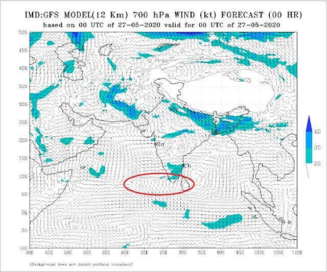 This could now evolve into a UAC and surface level low as explained yesterday, into a system.
Now, this Low ,AS-1 , is to be watched. Today, we have favourable Arabian Sea SST (30/31c) to strengthen the system. As explained, we have sufficiently warm waters in the Central Arabian Seas to help evolve good Cumulus clouds by reacting with the cooler water currents from the Somalia Currents.
AS-1 will form around 1st June. Then, the track and intensification is to be watched. Good track along a supportive Vortex in the off shore trough will help in Monsoon strengthening. but, a NW track , which will take place by High Ridge and WD resistance, will suck the moisture and currents away.
(Another completely separate system can form in the 55E region off South Oman coast by 31st)
But, as of today, the formation of the low is encouraging the Monsoon winds in the region.
 Good pre monsoon showers are recorded in Sri Lanka last 24 hrs.
Kukulaganaga 260 mms, Canawarella 60 mms, Badaragama 59 mms, Mellawa 57 mms, Moraliya-Oya 51 mms, Yatiyanthota 40 mms.
Rainfall expected to enhance as per Sri Lanka Met Dept.
----------------------------------------------------------------------------------
Reply to Query: Reliable Data can be obtained from Vagaries:
Vagarian Abhijit gives the Rainfall in Cherrapunji last 7 days
May 21st :94 mms, 22nd :213 mms, 23rd: 328 mms, 24th: 322mms, 25th:242 mms, 26th 195 mms, 27th: 244 mms = 1638 mms
An Upper Level trough is spotted in the South East Arabian Sea around Maldives/Lakhadweep Region.
Now, this Low ,AS-1 , is to be watched. Today, we have favourable Arabian Sea SST (30/31c) to strengthen the system. As explained, we have sufficiently warm waters in the Central Arabian Seas to help evolve good Cumulus clouds by reacting with the cooler water currents from the Somalia Currents.
AS-1 will form around 1st June. Then, the track and intensification is to be watched. Good track along a supportive Vortex in the off shore trough will help in Monsoon strengthening. but, a NW track , which will take place by High Ridge and WD resistance, will suck the moisture and currents away.
(Another completely separate system can form in the 55E region off South Oman coast by 31st)
But, as of today, the formation of the low is encouraging the Monsoon winds in the region.

Kukulaganaga 260 mms, Canawarella 60 mms, Badaragama 59 mms, Mellawa 57 mms, Moraliya-Oya 51 mms, Yatiyanthota 40 mms.
Rainfall expected to enhance as per Sri Lanka Met Dept.
----------------------------------------------------------------------------------
Reply to Query: Reliable Data can be obtained from Vagaries:
Vagarian Abhijit gives the Rainfall in Cherrapunji last 7 days
May 21st :94 mms, 22nd :213 mms, 23rd: 328 mms, 24th: 322mms, 25th:242 mms, 26th 195 mms, 27th: 244 mms = 1638 mms
Tuesday, May 26, 2020


Monday, May 25, 2020
Posted Monday 25th May 1 pm IST:
Weak Monsoon advance in Andaman Region..
Feeble Monsoon also advancing into Maldives with Gan getting 29 mms and Kadhedhoo 10 mms..

Reasonably good SST near Somalia Coast and Monsoon clouds formation mid Arabian Sea.


However, with a Low pressure (AS-1) developing around 1st June in the South East Arabian Sea, we will track the system and then be in a position to monitor the Monsoon further advance.
If the System , as it develops, tracks NW or North..the Monsoon Current and movement will depend on it..
See Author's Page Updates 😊
Weak Monsoon advance in Andaman Region..
Feeble Monsoon also advancing into Maldives with Gan getting 29 mms and Kadhedhoo 10 mms..

Reasonably good SST near Somalia Coast and Monsoon clouds formation mid Arabian Sea.


However, with a Low pressure (AS-1) developing around 1st June in the South East Arabian Sea, we will track the system and then be in a position to monitor the Monsoon further advance.
If the System , as it develops, tracks NW or North..the Monsoon Current and movement will depend on it..
Sunday, May 24, 2020


Saturday, May 23, 2020
Posted 23rd May Saturday Afternoon:
Mini Monsoon Watch-4:
South West Monsoon

But we can advance it as the major 200 level jet streams are well positioned.

From Thai Met Office: "During 23 - 25 May, the southwest monsoon prevails over the Andaman Sea ":

Pre Monsoon showers in Maldives yesterday have precipitated 35 mms in Gan and 26 mms in Kaadhedhoo. Trace in Male.
Monsoon can move into Maldives region around 27th May.
After this , what we require is a gradient, pressure gradient. This will form with the NW heating more, and seasonal low forming to create a steep gradient from the Thar Region to South Kerala Seas.
Current Core Low around 1000/1002 hpa.
For this, the Friday 22nd May Day temperatures indicate the heating has started.

Mini Monsoon Watch-4:
South West Monsoon
Bay Branch:...Latest lower and 850 wind charts show the Monsoon
2020 advancing into Andaman Islands as a weak current. The depth of the South West winds are not sufficient enough..(700 level winds not in position yet) over the Islands, hence current is weak.

But we can advance it as the major 200 level jet streams are well positioned.

The Arabian Branch; Current Cross Equatorial winds in full swing.
The Somalia Current is gearing up, and reducing the SST at the Somalia coast at a fast rate...

Thus the formation of Cumulus and thicker clouds over the South West Arabian Sea is hastened.
Pre Monsoon showers in Maldives yesterday have precipitated 35 mms in Gan and 26 mms in Kaadhedhoo. Trace in Male.
Saturday 10.45 IST Satellite Image

Monsoon can move into Maldives region around 27th May.
After this , what we require is a gradient, pressure gradient. This will form with the NW heating more, and seasonal low forming to create a steep gradient from the Thar Region to South Kerala Seas.
Current Core Low around 1000/1002 hpa.
For this, the Friday 22nd May Day temperatures indicate the heating has started.

Thursday, May 21, 2020
Posted 21st May:
Shifting attention from "Amphan" to South West Monsoon now...
Quote from Thai Met Department today.. " The rather strong southwest monsoon prevails across the Andaman Sea and Thailand. Heavy rains will be forecast in some parts of Thailand. People in the areas should beware of severe conditions. The moderates wind waves are likely in the Andaman Sea."
Winds show strengthening for Monsoon to advance into complete Andaman area in next 2 days..
Good favourable winds getting ready in Andaman advance soon..

 200 Jets winds now getting to steer Easterlies from the Andaman sea..
And 850 winds strong Westerlies and favourable OLR and Total Precipitable Water moving West towards the Advancing region.. seeing advance over Maldives next 3 days...
Heat Wave:
Heat increase likely in Gujarat, M.P. and Delhi in the next 3 days.
Delhi will see Day temperatures rising to 43/44c.
Shifting attention from "Amphan" to South West Monsoon now...
Quote from Thai Met Department today.. " The rather strong southwest monsoon prevails across the Andaman Sea and Thailand. Heavy rains will be forecast in some parts of Thailand. People in the areas should beware of severe conditions. The moderates wind waves are likely in the Andaman Sea."
Winds show strengthening for Monsoon to advance into complete Andaman area in next 2 days..
Good favourable winds getting ready in Andaman advance soon..

850 level winds


Total Precipitable Water

And 850 winds strong Westerlies and favourable OLR and Total Precipitable Water moving West towards the Advancing region.. seeing advance over Maldives next 3 days...
Heat Wave:
Heat increase likely in Gujarat, M.P. and Delhi in the next 3 days.
Delhi will see Day temperatures rising to 43/44c.
Subscribe to:
Posts (Atom)
27th June Current Scenario: Good rainfall along trough Deficency in Maharashtra/Gujarat as on 27th June Mumbai day frequency rain last 4 ...

-
 Short Narration: Monday 1st/Tuesday 2nd : The heaviest rains are in Madhya Maharashtra, Marathwada, North Interior Karnataka and No...
 -
 Much Awaited Monsoon Analysis to Date from ..None Other than Our GSB..on "Stats and Analysis" Page..Just Recieved On Saturday ...
