Wednesday, November 30, 2016

Posted Wednesday Night:

BB-17 has been upgraded to Cyclone "Nada" status by IMD and International Weather Models.

As per IMD Bulletin .." The cyclonic storm “Nada” over southwest Bay of Bengal moved northwestwards during past six hours with a speed of about 27 kmph and lay centred at 1730 hrs IST of today, the 30th November, 2016 near Latitude 9.8ºN and Longitude 84.0ºE over southwest Bay of Bengal, about 550 km southeast of Chennai,"

Moving along the Southern Edge of the Sub Tropical Ridge, this "Cyclone" will track towards the Tamil Nadu coast. 

Please not I have put "Cyclone" into inverted commas.Estimated central Pressure is 1000 mb and estimated core winds at 40 knts, 

Heavy showers expected in Chennai from 1st December, amounting to around 50 mms. Rains will decrease to half the amount on 2nd and substantially decrease thereafter.

Tuesday, November 29, 2016

Posted Tuesday 29th Night:

BB-17 is now a Depression, estimated location on Tuesday night is at 6.5N and 87.1E. No change in track forecast.
Chennai: Squally weather from 30th, with very windy conditions on 1st, winds gusts upto 45-50 kmph. Thunder showers on 1st December.Around 50 mms of precipitation expected.
Bangalore: Showers on 1st December, with cool day at around 24c, Can expect around 25 mms on 1st.

Mumbai: Mumbai skies will get partly cloudy the next 3 days, Wednesday 30th - Friday 2nd December. 
Days, which are quite hot currently at 34-35c, will see a fall to 31/32c levels. But, no appreciable fall seen in the night temperatures.Maybe a marginal rise in the minimum temperatures from Wednesday night.

Pune: Next 3 days will be partly cloudy to cloudy on Thursday. Substantial drop in day temperatures from the 34/35c levels. But rise in night temperatures, maybe by 5c...minimum rising to around 15c from Wednesday night.

Monday, November 28, 2016

Posted 28th November Night:
Initial Gear Up of NEM ...

As mentioned yesterday, BB-17 has formed and is a Well Marked Low in the South -East Bay Region as on Monday evening. System is intensifying fast, and can become a depression by Tuesday Night. 
Tracking NW and heading towards Tamil Nadu Coast as expected.Could cross South of Chennai around 1st. By 3rd, BB-17 ( Weak Low) re-emerges in the Arabian Sea off Kerala Coast.
Squally winds likely along TN coast from 30th, and rains commencing from 1st December.
BB-18 follows soon...

Chennai: Rains expected from 30th evening. Around 55-60 mms from  30th Night-1st Night. Gusty winds and squally weather, with wind speeds peaking around 55-60 kmph on 1st December.
Bangalore: Thursday 1st December, and the city will cool down with heavy showers in most parts. With around 15-20 mms on Thursday, the day's high will be around 25c. Friday 2nd, will be overcast with lesser rains, but cooler day at around 22/23c.

Mahableshwar (Maharashtra) , a hill station at an average height of 4400 feet above sea level, recorded its hottest ever November day at 32c !
Bangalore, the Garden City, also saw a new November record at 33c !
The Day Night range continues in Maharshtra. 
Shivkumar Mogal sends this table of 28th November.

Posted 28th November Night:
Initial Gear Up of NEM ...

As mentioned yesterday, BB-17 has formed and is a Well Marked Low as on Monday evening. System is intensifying fast, and can become a depression by Tuesday Night. 
Tracking NW and heading towards Tamil Nadu Coast as expected.Could cross South of Chennai around 1st. By 3rd, BB-17 ( Weak Low) re-emerges in the Arabian Sea off Kerala Coast.
Squally winds likely along TN coast from 30th, and rains commencing from 1st December.
BB-18 follows soon...

Chennai: Rains expected from 30th evening. Around 55-60 mms from  30th Night-1st Night. Gusty winds and squally weather, with wind speeds peaking around 55-60 kmph on 1st December.
Bangalore: Thursday 1st December, and the city will cool down with heavy showers in most parts. With around 15-20 mms on Thursday, the day's high will be around 25c. Friday 2nd, will be overcast with lesser rains, but cooler day at around 22/23c.

Mahableshwar (Maharashtra) , a hill station at an average height of 4400 feet above sea level, recorded its hottest ever November day at 32c !
Bangalore, the Garden City, also saw a new November record at 33c !
The Day Night range continues in Maharshtra. 
Shivkumar Mogal sends this table of 28th November.

Sunday, November 27, 2016

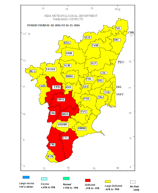
Thirivallur & Puducherry -92%, Kancheepuram -88%, Nammakal -87%, Salem & Vellore -86% and Chennai -83%...to mention a few,a very poor picture is depicted for Tamil Nadu. (Below)
i) After a very Poor November Start for the North East Monsoon, things seem to be looking bright soon.
After the formation of the much awaited trough, On 28th November, low pressure (BB-17) is forming at 5N and 90.5E in the South East Bay.....System will intensify, and track towards the Tamil Nadu coast. The intensified system may cross as a Deep Depression South of Chennai around 1st December.
Squally winds are likely along the T.N. coast from 30th November.
Studying the current possible scenario and BB-17 strength, the estimated rain amounts ( estimated as on 27th November) for Chennai would be around 55-60 mms on 1st, and then reducing to around 15-20 mms on 2nd December. But we will judge and monitor the developments daily.
BB-17 will weaken on crossing, and a weak Low will re-emerge in the Arabian Sea.

Another back to back Low, BB-18, is possibly forming in the same 5N and 90E region around the 3rd of December. Along a trough, the BB- 18 will track almost along the BB-17 track towards TN.


ii) Massive temperature variations were seen in some Maharashtra towns on 26th/27th November...

On 26th November Ahmednagar (Maharashtra) max temp 35.4°C and min temp 6.6°C. So, Temperature difference was 28.8°C.(Ahmednagar record and India range record is 29.2c on 15th December 2003.See here on the page for more variation ranges and Sub Continent record of 29.5c...

on 27th, Mumbai Scruz saw a difference of 19.6c, (high for a coastal city), when the day was 36.2c and night 16.6c. 
Pune saw a range of 22.8c, with 32.1c as the high and 9.3c as the low.


Friday, November 25, 2016


RAINFALL REPORT (01-10-2016 TO 23-11-2016)  
TOTAL ALL INDIA RAINFALL (as on 23-11-2016) 61.3 mm
SEASON +/- (from 1-10-2016 to 23-11-2016) -42%
RAINFALL PER DAY this season 1.14 mm
TOP FIVE SUBDIVISIONS THIS MONTH upto 23rd Nov mm
A & N ISLAND 425.0
N M M T   # 202.7
ARUNACHAL PRADESH 184.8
KERALA 162.3
SHWB & SIKKIM 155.6
 
BOTTOM FIVE SUBDIVISIONS THIS MONTH upto 23rd Nov  mm
WEST UTTAR PRADESH 9.6
HIMACHAL PRADESH 5.3
HAR. CHD & DELHI 5.2
JAMMU & KASHMIR 3.3
PUNJAB 2.4
 
TOP FIVE SUBDIVISIONS ABOVE NORMAL (1-10-2016 to 23-11-2016) %
WEST RAJASTHAN 159%
SAURASHTRA & KUTCH 134%
GUJARAT REGION 116%
EAST RAJASTHAN 44%
CHHATTISGARH 14%
BOTTOM FIVE SUBDIVISIONS BELOW NORMAL (1-10-2016 to 23-11-2016) %
S. I. KARNATAKA -83%
RAYALASEEMA -90%
HIMACHAL PRADESH -90%
PUNJAB -91%
JAMMU & KASHMIR -95%
 
#    NMMT : NAGALAND,MANIPUR,MIZORAM AND TRIPURA source -IMD

Thursday, November 17, 2016

Posted 17th November 2016:
Why is the NEM Weak this year (as yet)...an brief analysis from Vagaries.

While reading this , compare the article of the normal conditions and parameters of the North East Monsoon on this link from Vagaries.

The Deviations seen and observed this year from the normal are:-
1. Today the Centre of 500 level Anti Cyclone is located over Southern India. Normal should be moving towards Central Myanmar.

2. Upper Air currently warmest between 10N and 20N (at -5c)..while normally it should be over 10N and upper air temperature gradually decreasing Northwards.

3. In the jet streams, S/SW winds are dominant as of today. Not Westerlies as required.

4. No prominent Low pressure (Larger) region seen in Bay. No trough extending Westwards (to embed a Low) seen forming.

5. Presently very weak or Negative MJO prevailing in Bay region. Prevents the entry or formation of any system from the far east pulse.

6. Read "A brief Analysis of the "Peninsular" rainfall for the period October to December." by GSB on the link.

See Blog below for actual performance till date.

Wednesday, November 16, 2016

Posted Wednesday 16th November:

Very Poor Performance as on date of North East Monsoon..... Large Deficient in South India:
No major rains or recovery in Southern Region for next 8-10 days...Bangalore and Chennai do not get any meaningfull rains next 8 days at least.

Some Largely Deficient Districts in:From 1st October - 16th November

Tamil Nadu:                       Actual     Normal
TIRUVALLUR                    33.4        380.0     -91%    LARGE DEFICIENT
PUDUCHERRY                  44.4        481.3     -91%    LARGE DEFICIENT
KANCHEEPURAM            50.1        397.8     -87%    LARGE DEFICIENT
NAMAKKAL                      31.6        223.2     -86%    LARGE DEFICIENT
SALEM                                42.1        269.0     -84%    LARGE DEFICIENT
VELLORE                           38.1        242.1     -84%    LARGE DEFICIENT
KARUR                               37.9       223.3      -83%    LARGE DEFICIENT

CHENNAI                            94.3       499.5      -81%    LARGE DEFICIENT
KRISHNAGIRI                    43.2        226.3     -81%    LARGE DEFICIENT

Kerala: (upto 16th November)                                        Actual     Normal
KOZHIKODE                                51.3       360.4     -86%    LARGE  DEFICIENT
KASARAGOD                              45.5       291.3      -84%    LARGE  DEFICIENT
THIRUVANANTHAPURAM      73.2        408.1      -82%    LARGE  DEFICIENT
KANNUR                                      67.1       292.8      -77%    LARGE  DEFICIENT
WAYANAD                                    71.8       274.6     -74%    LARGE  DEFICIENT
IDUKKI                                       153.9       467.7      -67%    LARGE  DEFICIENT

Karnataka:(upto 9th November)
                                                            Actual   Normal
COASTAL KARNATAKA    
DAKSHINA KANNADA                     64       275      -77%
N. I. KARNATAKA    
BAGALKOTE                                       15       126      -88%
BELAGAVI                                           18       131      -86%

DHARWAD                                           22       136       -84%
GADAG                                                   3       135       -98% 
HAVERI                                                   8       135       -94% 
KALABURGI                                        38       114       -67%
KOPPAL                                                28       120       -77%
RAICHUR                                             16       119       -86%
VIJAYAPURA                                       21       124       -83%
YADGIR                                                18       135       -86%

S. I. KARNATAKA    
BALLARI                                              13       131       -90% 
BENGALURU RURAL                        61       199       -69%
BENGALURU URBAN                       35       184        -81%
CHAMARAJANAGAR                        18       186        -91% 
CHIKABALLAPURA                          13       181        -93% 
CHIKKAMAGALURU                        26       192        -87%
CHITRADURGA                                  21       131        -84%
DAVANGERE                                       13       143        -91% 

Thursday, November 10, 2016

Good News for Chennai...Rains Thunder Shower very much Possible on Saturday and Sunday...Much delayed and needed..!


Map from IMD RMC, Delhi

Monday, November 07, 2016

7th November 2016..
This Image of 7th November reminds me words of the Carpenters' Song...."Not a Cloud in the Sky, Got the Sun in my Eyes..."


Synoptic Situation on 7th November 2016 over Sub Continent:
Low Pressure : Nil
UAC : Nil
Trough : Nil.
WD: None over Sub Continent

Day Temperatures  Departure from Normal:


Night Temperatures Departure from Normal:


Delhi NCR Air Pollution:
International Business Times: "Nasa images expose ugly truth about hazardous air pollution in Delhi
Nasa images indicate it's not Diwali but the smoke released from burning of crop stubble that could have chocked Delhi.
An estimated 32 million tons of leftover straw is burned by farmers for winter wheat crop, according to the NYT."

Saturday, November 05, 2016

Posted Saturday Night....5th November 2016...
Wither North East Monsoon ?


And Karnataka (Below)....


And the days are getting hot, breaking November records at Tirupathi, Ongole, Nellore, Dharmapuri and Salem....


Posted Saturday Night....5th November 2016...
Wither North East Monsoon ?


 And the days are getting hot, breaking November records at Tirupathi, Ongole, Nellore, Dharmapuri and Salem....


Friday, November 04, 2016

Posted Saturday Mid Day:
 

In a sudden swift movement, BB-15 has tracked fast towards the NE, and moved almost 200 kms in the last 8 hrs from the last report (Below). It now lies about 300 kms E/NE of Vizag.
At this speed, expected to cross into Bangladesh Coast between Barguna and Chittagong on Sunday.


Showers would increase in Kolkata from Saturday evening itself, and would measure around 60-70 mms from Saturday evening -Sunday evening.Winds would sustain at around 30 kph and peak at 35-40 kph.Cool day at around 24c on Saturday and Sunday.

Posted Friday 4th Night:

BB-15 (Depression) is moving along the East Coast and is positioned 200 kms SE of Vizag on Friday Night. Grazing the Odisha Coast, the system will track towards Gangetic West Bengal.
As mentioned in earlier post, rainfall may decrease in TN from Thursday Friday levels next 2 days.

Expected Weather next 2 days in:
Kolkata: Saturday: Overcast with occasional showers, some showers heavy. Sunday: Increase in rainfall as thunder showers lash city with squally winds. 

Bhubaneshwar:Thunder storm /Dust storm possible on Saturday. Heavy falls in spurts.Decreasing condition of rain on Sunday, with overcast skies on Sunday.

Chennai: Decrease in rains as mentioned earlier...and rise in day temperatures.

Wednesday, November 02, 2016

Approaching WD likely to Re Curve BB-15 towards NE towards Bengal...Currently BB-15 is centred Mid Way in the Bay of Bengal Between TN/AP Coast and Andaman Islands

Posted Wednesday 2nd November Night:

Due to absence from writing this blog, I am late in announcing the formation of the new system BB-15. It is currently at 13N and 88.5E, West of the North Andamans. System is now a Well Marked Low. It is likely to intensify into a Depression and move W/NW .
As BB-15 intensifies beyond Depression and tracks W/NW, heavy falls are likely over Coastal A.P, Coastal Odisha on Friday and Saturday.
After good rainfall in Tamil Nadu on Thursday, the intensity of rainfall may decrease in T.N.
Chennai will get some showers on Thursday, and rainfall may decrease on Friday and Saturday. Day temperatures rise on Friday and Saturday leading to hot day.

A Northern WD is likely over Kashmir and H.P. on Friday and Saturday. WD will be weak and will precipitate moderate rains in Kashmir Valley and snow over the Hills of H.P. and Kashmir.

A slight fall in day and night temperatures are expected from Friday in North -West and Central India. 
Shallow fog likely in Punjab and Haryana and parts of Delhi on Friday morning.
There could be stronger NW winds in Delhi NCR after 6th November.

Tuesday, November 01, 2016

Wishing All Readers and Vagarians  
A Happy Diwali and Prosperous New Year

-Vagaries

 13th September  Early Snowfall in Higher Reaches of Uttarakhand.  Latest on Enso ENSO ALERT SYSTEM:   El Niño or La Niña Watch:  Issued whe...