Sunday, April 30, 2023

Dr.Vineet has updated his page also 

Cool April for Pune

The average maximum temperature in Pune (Shivajinagar) in April 2023 is 36.7C which is 2.5C less than last year April and 1.2C less than climatology. The attached graph shows the daily maximum temperature variation in April 2021 (Black),2022 (Red) and 2023 (Blue). Data: IMD


 30th Refresh

Not unique, but rare...

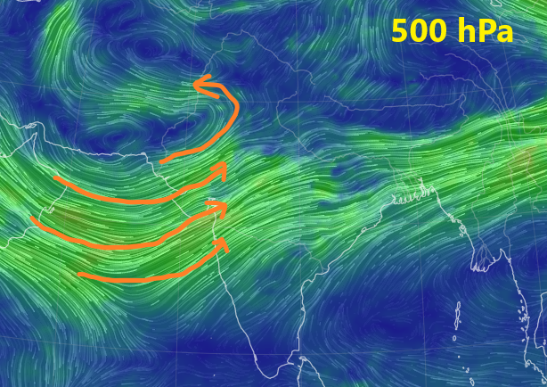
This current b2b series of WDs is not a common occurrence for end April/early May. And specially with the  200/250 level trough dipping south to Gujarat and Maharashtra ( and Kutch) is a bit out of tune.

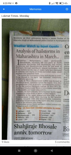
I recall same in 1990 and 1970 ...if my records and memories are correct. My 2014 clipping 


Normal for second half of April early May is showers through LWDs for interior peninsula. LWDs assist and required to build up a fulcrum for the "Seasonal Low"

So the fulcrum is struggling today.

Good hope for change in WD course is the Bay Low coming in around 5th May.

Saturday, April 29, 2023

Posted 29th April Morning:

Outlook till Wednesday 3rd May: The relentless onslaught of strong Western Disturbances continues...


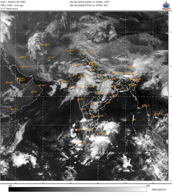
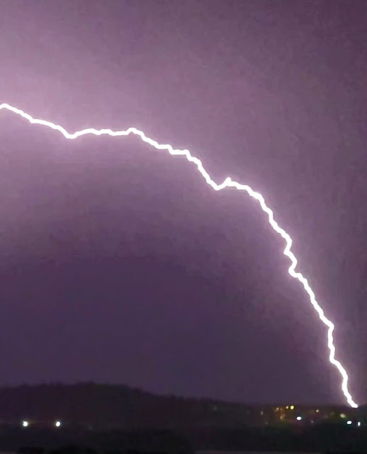
Mumbai: Passing showers were witnessed in some regions of suburbs and Thane today morning of Saturday 29th April. 


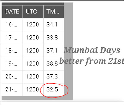
Max temperature to be around 32-33°C for Mumbai, bearable due to westerly winds and partly cloudy skies, although humidity can be high. Min to be around 24°C. Chance of some passing showers in some areas..

Pune: Some rain/thundershowers can occur in patches around the city and nearby hills today 29th and tomorrow 30th. Below normal max temperature of around 35-36°C. Min will be around 20°C. 

Interior konkan may see around 36-38°C max temperature. 

Passing showers/thundershowers likely for another 2 days over north Konkan and north Madhya Maharashtra region (Nashik, Dhule).


Marathwada and Vidarbha region: Thunderstorms likely for 2-3 days till 2nd May. 

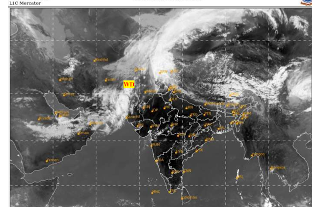
A strong Western Disturbance with trough dipping south into the Arabian Sea will affect weather over many parts of the country, and keeping temperatures below normal over most of west, north and northwest regions. 


Many places in Gujarat will get rain/thundershowers today. 

Rajasthan, Punjab, Haryana, Delhi NCRUttar Pradesh, Madhya Pradesh, Chhattisgarh, Jharkhand to receive rain/thunderstorms with chance of hail in the coming 4-5 days. Cloudy weather can keep daytime weather cooler than normal. Some places can receive some moderate to heavy showers. 

Himalayan regions of Jammu, Kashmir, Ladakh, Himachal Pradesh and Uttarakhand to receive moderate to heavy rain in low-mid elevations and snow in higher elevations. Plan travel accordingly. 


East coastal states to also receive thunderstorms. 

Assam and Meghalaya to receive thundershowers. 

Arunachal Pradesh Himalayas to also get rain/snow. 


South peninsula: Line of wind discontinuity to cause moderate to heavy thunderstorms across south interior Karnataka (Bangalore/Mysore), Kerala, interior Andhra Pradesh, Telangana and interior Tamil Nadu. 

Thursday, April 27, 2023

Monsoon Watch - 3..2023...28th April

Current Scenario of Developing Parameters:

1. 

Indicator: Eastern Bay Branch -ve

2. Core Pressure of Seasonal Low persisting at 1004 hpa...( For similar comparisons of some previous years:1004hpa in 2014, 1000hpa in 2015, 1002 hpa in 2016 on same end April dates.)


3.The NW plains heating picked up initially, but stabilised again, as WDs started streaming in.

After the early summer onslaught, the heat steadied a bit over the North and west subcontinent between MW-2 and MW-3 period. Central India became near normal/below normal (No heat wave)

Indicator: -ve

4.Jet Streams (Most Important)

The 200 hpa Jet streams over the subcontinent is the additional parameter to be watched from MW-3 onwards .

The jet streams are to be followed as the westerly jet 

core shifts to the 

north and easterly jet 

stream is formed, over the course of late summer, 
progressively 

from south to north of 

the subcontinent , 

heralding the 

progress of south-


west monsoon over 


the subcontinent.


Currently not 

organised ...need to become Easterlies.

They are required to strengthen to 

easterlies at 95E 

latitudes in the 

coming days, for 

heralding the SWM to 

the South Andaman Sea.
Indicator :-ve

Note:

The South-West Indian Monsoon Season may be delayed in the Andaman Islands arrival by a few days i.e around 18th May. 

But the Arabian Sea Branch seems to show and indicate a delay of around 3/4 days i.e. Arrival at Kerala by around 3rd-5th June.

Vagaries' would estimate a near normal monsoon overall (97%-100%). The quantum and strength may lag in the second half of the season

IMD has estimated this years Monsoon quantum at around 96% +- 5% of the normal. That would mean in normal range.
Other competent Forecasters have indicated a weaker Monsoon
.

*But, situations can change fast, and by the time we discuss the next  MW, some factors can suddenly become +ve or -ve. So, MW discusses and follows the developments as they emerge, and discuss the parameters as is where are.


Monsoon Watch is reflecting Vagaries' views..Monsoon Watch should not be used/depended upon commercially or otherwise. Monsoon Watch Series may differ from other models.
.

 Monsoon Watch -3 and Monsoon Dates by 11 pm IST Thursday

 27th April..


                No Major Heat Wave Expected " as mentioned on 23rd (Last Post) 

                                     👇

Sunday, April 23, 2023

Next week 24th -27th April:..No Major Heat Wave..Normal Temperatures.

Mumbai: 24th - 27th:Partly cloudy weather, 

Temperatures around 33/34c, but with high humidity making it sweaty and uncomfortable .Real feel around 37c.  

Eastern townships (Navi Mumbai, Panvel, Karjat) will be around 40c, with Light thundershowers expected on 25th-27th. 

Pune can expect thundershowers on 25th-27th. days around 36/37c.

Sambhajinagar ( Aurangabad) can expect thundershowers on 25th-27th.

Vidharbh can expect squally winds and hail.

Rain Thundershowers with hail expected in Marathwada and Madhya Maharashtra on 25th-27th. 

Gujarat remaining dry. Gujarat region & Saurashtra may see days around 40c, Kutch also around 40/41c.

Saurashtra: Few localised Thundershowers could pop up.

The week 24th-27th: Rain/Thundershowers with hail expected in Chattisgarh, Vidharbh, and Telengana .

Delhi after some showers on Monday 24th, expected to be dry, but temperatures rising to touch 40c by 26th.


 .

April 23rd: India's hype on Heat Wave fizzles out..!Most temperatures normal/below normal...No Major Heat Wave expected.


Friday, April 21, 2023

Monsoon Watch -2 ...2023....21st April.

1.Mascrene Highs...Formations below the Normal requirement.

Indicator: Negative

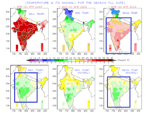
2. Seasonal Pre Monsoon Heat...well, aware there is complaint of "Heat" (though no heat wave seen), but observe the real scene.

The squares show the "below normal" anomaly. The Monsoon parameters see this....reality

Indiacator: Negative

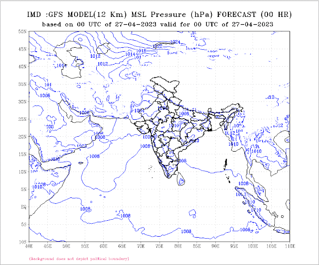
3. Seasonal Low

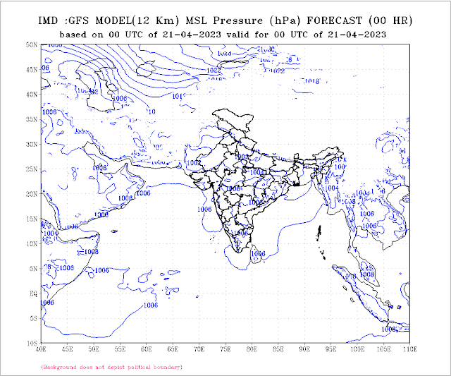
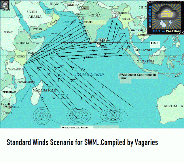
Core between 1002/1004 hPa..Fairly good..As mentioned, by end May/early June it normally should reach a low nadir of 994 mb in June in the Thar Desert, and with 1008mb in the South Arabian Sea, a perfect gradient is created to attract the south -west winds towards the coast.

Indictor: Good.

4. The Line of Wind Discontinuity in Peninsula India, should normally stabilise around Central India perpendicular down into the Southern Peninsula by mid April. 
But this year it has been active first half of April, and fizzling out now.

Indicator: Weak.

5. ENSO;
The El Niño–Southern Oscillation (ENSO) is neutral, and with signs of El Niño forming after July.
But El Nino is not the only parameter fir estimating our Monsoon.

Indicator: Neutral.( Would maintain this position).

6. Bay Low:
The Bay has yet to host a pre monsoon low during  April. 
As discussed, we should normally see a low sometime after the 15th of April. 
Another factor, which helps the winds gain strength, and bring more moisture into the Indian landmass, is the sea temperatures on both sides of the Peninsula. 
Needs to warm up more..👇
No Low seen till April End.
Indicator: Negative

Overall Summary:2 Parameters Weak/Neutral...3 Negative.
Seems (without commitment today)..SWM onset could be delayed...

But, situations can change fast, and by the time we discuss the next MW, some factors can suddenly become +ve or -ve. So, MW discusses and follows the developments as they emerge, and discuss the parameters as is where is. 

No model can commit  today when the Monsoon can arrive. 

Also, Quantum of rain forecasting in April for June right through September is an impossible task. Things get clearer by last week of April. 
Vagaries' (in MW) normally remains true to estimates around early May. 

Outlook for weekend 21st/22nd/23rd April

Mumbai: Max temperature to drop to around 35°C, good westerly winds from afternoon. Partly cloudy weather in the evening. Min temperature around 25°C.

Interior Konkan (Panvel, Navi Mumbai, Thane, Karjat) to see max temperature dropping till about 37-39°C range, due to strong westerly winds in the afternoon and evening hours. 

Pune: Hot daytime...max around 39°C. Chance of rains reducing from today and over the weekend. Westerly winds towards late afternoon/evening. 

Min temperature can be around 21°C. 

With west winds strengthening, the LWD shifts towards east Coastal states, rain chances reduce for western Maharashtra. 


छ. संभाजीनगर (औरंगाबाद): पुढील २-३ दिवस हवामान कोरडे राहील. कमाल तापमान साधारण ३९-४०° सेल्सिअस, हवेतील आद्रता कमी असेल.

Thursday, April 20, 2023

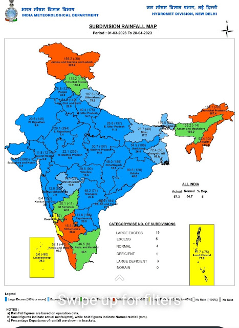
After a Volatile March, North India/Peninsula India witnessed Pre Monsoon rain in early April 2023 also..

 As a result, the temperatures were low during the early April pre-monsoon period compared to last year.

India, especially the northern regions of the country, witnessed a cooler April this year, compared to 2022. 
From March 1 to April 12, the departure of the all-India cumulative rainfall from the long average period rainfall was over 19 per cent.


The rainfall in April is generally attributed to Western Disturbances in North India,. Depending on their intensity, duration and location, Western Disturbances can result in rain, snowfall, cold waves, and even flash floods in the region,”

This cannot be claimed as "Climate Change"...
“The impact of climate change can only be confirmed if a trend continues for 30 years,” Dr Gupta (IIM) said.

Wednesday, April 19, 2023

Soaring heat in Maharashtra!

 Some maximum temperatures recorded across the state in °C below on 19th April 2023:


1. Mangaon (Raigad): 44.4                 


2. Kindivate (Poladpur):44.3

3. Thane: 44.2

4. Nilje (Near Shiphata): 44

5. Nandgaon: 43.8

6. MaliKondvani (Raigad): 43.7

7. Vinhere (Mahad): 43.6

8. Gokhivare (Vasai East): 43

9. Umbarde(Kalyan): 42.9

10. Cherawali (Panvel): 42.8

11. Daund (Pune): 42.6

12. Khandat (Chiplun): 42.4

13. Kondhavi Fort(Poladpur) & Kasegaon (Sangli): 42.3

14. Palaspe: 42.2

15. Karjat (Nagar): 42

16. Chiplun: 41.8

17. Theur (Pune): 41.7

18. MahiJalgaon (Nagar) & Bibwewadi (Pune): 41.5

19. Varvand (Pune): 41.6

20. Belsar (Pune): 40.6

21. Chembur (Mumbai) & Angavali (Ratnagiri): 40.5

22. Ranjangaon (Pune): 40.4

23. KoregaonBhima (Pune): 40.3

24. Aundh (Pune):40.2


Data Credits: Skymet Aws

Compiled By: Vagarian Abhishek Apte

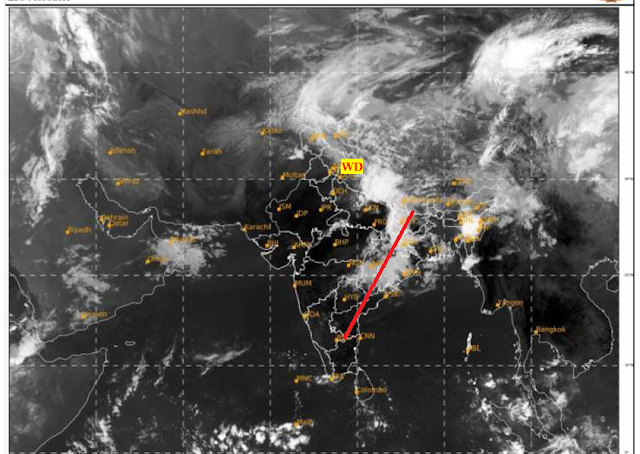
 19th April..

FAQ: Reason for the Development last 2 days around Surat...See below Image


Tuesday, April 18, 2023

Outlook till Friday 21st April: 

Heatwave to persist in West Bengal till 21st.. After which  thunderstorms are expected. 


Seasonal pre-monsoon thunderstorms, locally called 'Kalbaisakhis' are likely across West Bengal and Odisha mainly towards the end of the week around Friday 21st onwards.

Heat and temperatures exceeding 40c temperatures likely in Vidharbh and Chattisgarh also.
Some Thundershowers i Vidharbh on 20th.

No heatwave is expected for Northwest India for next 4-5 days.

Moderate to strong WD to impact North India.


Dust storms followed by thunderstorms with chance of hails in parts of Punjab, Haryana, Delhi NCR, west UP for next 2-3 days.
Himalayan regions to get rain/thunderstorms with snow in high elevations. 


Sunday, April 16, 2023

El-Nino...Will it or will it not affect Our Summer Monsoon ?...

Neutral Conditions through the Northern Hemisphere spring (April/May), followed by a 62% chance of El Niño developing during May-July 2023. 

Models remain highly biased with El-Nino 

In the year 1997, very strong El-Nino prevailed,. 

The behavior of the 1997 monsoon is related to its evolution during June and July, with westward migration of cloudbands from West Pacific that increased convection (Depressions) over Bay of Bengal.

 A similar behavior has also been noticed during the 1983 monsoon, with precursors indicating a possible poor monsoon but subsequent events changed the course of the monsoon.

"Based on El-Nino considerations alone, it has been feared, in some quarters, that 1997 might become a year of extreme deficit summer monsoon rainfall. However, the actual rainfall over India during June – September 1997 was 2 % above normal. India Meteorological Department had predicted "normal" rainfall (+-10% of the rainfall)."

A positive IOD saved that year from a poor Monsoon.  

2023 year also positive IOD will evolve during monsoon months. 

Models are not considering its impact, they are heavily skewed with ENSO conditions. 

So,Vagaries still will maintain nothing can be said with certainty how the monsoon will unfold,

 However in recent decades North India rain has strong correlation with ENSO conditions. But again, recent decades stats show there is almost no correlation of Central India rain with ENSO conditions.

 Intensity of El Nino in June/July/August also uncertain...that can play a big role in forcing the atmosphere to respond to ocean conditions

Important  point to be considered: This year first three months have been very "volatile", in extremes, meteorologically speaking.. So model based predictions have to be very conservatively analysed.

Note:  El-Nino does not guarantee entire India will see below normal rain  

  1. In the past decade, the El Niño occurred in 2002, 2004, 2006, and 2009
  2. But 2002-03 was the only year that India showed negative agri sector growth with average rainfall dropping 20 per cent below normal.

We need to be watchful and alert... not get to hasty conclusions and panic.

Author's Note with contributions from Vag. Dr. Vinnet and Vag. Shreyas.

 Sunday  evening 


Saturday, April 15, 2023

 Saturday 15th evening...LWD...interesting 


West Bengal heats up...many places recorded above 40°C on Friday, 14th April🔥


We had mentioned about chances of heatwave across East India in our 9th April post...


Below are some maximum temperature readings from West Bengal:


Friday, April 14, 2023

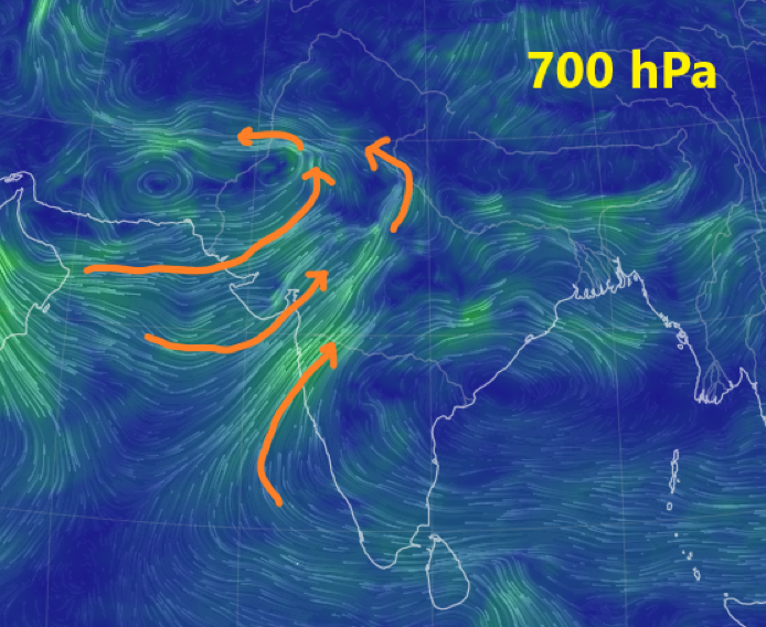
13th April:  Winds at 700 hpa levels indicate a Circulate

Rains/Thundershowers possible in Madhya Maharashtra and Marathwada..next 2 days


Thursday, April 13, 2023

Pune Scene on Thursday evening..cr.Vag Gokul

And this shot👇 by Proff. R. Kelkar Ex Director General, IMD
from Pune


Rainfall areas of Mumbai on 12th night/13th early hours 


Posted 12th night:
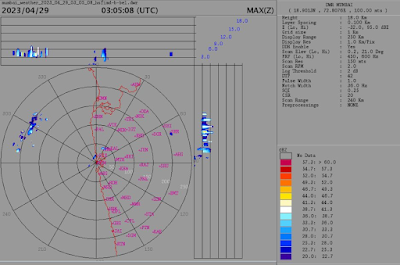
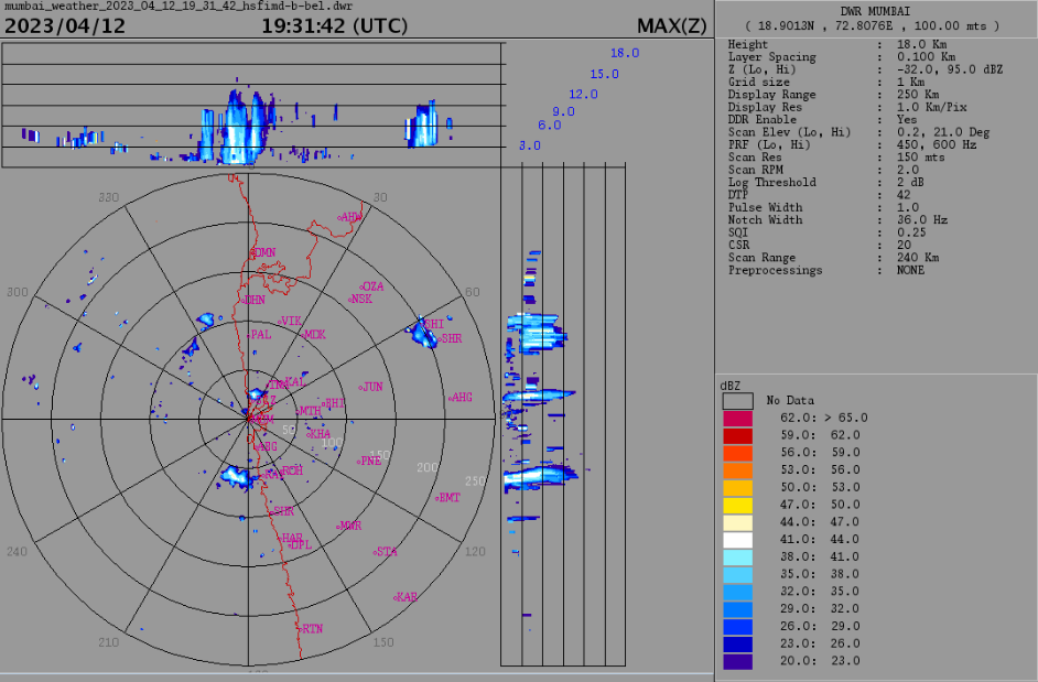
Mumbai region to see some rain/thunderstorms in some regions next 3 days and tonight!

Doppler Radar image showing some thundercloud development around western suburbs and parts of eastern suburbs. 

Rains can be localized and not well distributed. 


Some rainfall readings (in mm) for post-midnight Mumbai Rains:

Malwani 24.9 
Goregaon 16.5 
Borivali 18.8 
Andheri E 16.7 
Marol 13.9 
Chincholi Fire stn 11.9 
Kandivli 11.4 
Versova 8.1 
Malad W 8.3 
Dahisar 5 mm 

Most of the Mumbai rainfall concentrated over western suburbs!

(Data credits: MCGM)


Strong trough in 200 hPa jet stream over Arabian Sea will create upper-level divergence.
Low-level convergence from existing Line of Wind Discontinuity will be enhanced...so good conditions for towering clouds to develop along parts of konkan, Ghats and Madhya Maharashtra.

Model forecast for 250 hPa jet stream for 14th April shown below:


Konkan region to see some thundery activity for next 3 days till 15th April.


Wednesday, April 12, 2023

12th posting

Mild Alert ⚠️ 

Moderate rain or thundershowers ⛈ with hail and winds expected on 13th/14th/15th in Maharastra Districts of

1.Pune 

2.Nasik 

3. Sambhajinagar 

4. Jalgaon 

Tuesday, April 11, 2023

Hottest day of the season in Pune district. Some maximum temperatures recorded across Pune district below in °C:

Day on 11th...in line with our earlier 👇 forecast 


1. Koregaon Park:42.1

2. Talegaon Dhamdhere:41.3

3. Bibwewadi (Vag AWS): 41

4. Shirur:40.9

5. Shivajinagar AWS & WadgaonSheri:40.6.           

6. Dudulgaon:40.3

7. Rajgurunagar:40.2.          

8. Chinchwad:40.1

9. Lavale:40)


(Mumbai 36.2)

Data Credits: IMD 

Compiled by: Vagarian Abhishek Apte

Monday, April 10, 2023

Monsoon Watch - 1 2023....10th April 2023

A different March Scenario this year...so, we cannot go to the stereo type of "Watch" this year..

South West Monsoon Watch Series this year will vary as  as the March Weather was a bit extreme..Early readings for Monsoon Forecast: 

The first two weeks of March 2023 were no doubt among the hottest on record. But, drastically, the second half, was among the top 10 coldest March in the past 73 years.


To be sure, the first half of the month was above normal. .  All 

days except March 7 were warmer than normal from March 1 

to March 15.

But From March 16 onward, every day has been at least 1.3° cooler than normal. 
On average, the weeks ending March 21 and March 28 were 3.5° and 2.3° cooler than normal. . 

The average temperature during the week ending March 21, 28.44° was slightly lower than even the average for February (28.46 degrees
(Excerpts from IMD &HT)


The sudden cold in the latter half  of March was caused by  two active western disturbances, cyclonic circulations over Rajasthan and moisture from Bay of Bengal and Arabian Sea due to anti-cyclonic circulation there , jet streams with  speed 150-180 kilometres per hour  in the upper troposphere,  resulting in sustained rainfall and thunderstorm, often accompanied with hailstorm.
-------------------------------------------------------------------------------


Current Scenario:

*ENSO-neutral conditions are observed.

* Equatorial sea surface temperatures (SSTs) are near average across most of the Pacific Ocean. 

*The tropical Pacific atmosphere is still consistent with a weak La Niña signal. 

*ENSO-neutral conditions are expected to continue through the April/May/June and June 2023.


Standard Winds Scenario for SWM...Compiled by Vagaries
👇

Soon, we will give the Monsoon Estimate....As of now seems Late...!

Next Monsoon Watch-(2) on 20th April


  Posted 18th Afternoon: Mumbai : Much hear say about rains increasing, cyclones coming in end of September ! Vagaries ' outlook for  18...