Monday, July 31, 2023


 महाराष्ट्रातील घाट आणि निवडक शहरे 31/7/2023 रोजी सकाळी 8:30 वाजता संपणारा एकूण हंगामी पाऊस (जून आणि जुलै 2023):


1. पाटगाव: 5000 मिमी
2. आंबोली: 4860 मिमी
3. ताम्हिणी: 4578 मिमी
4. दावडी: 4344 मिमी
5. माथेरान: 4153 मिमी
6. जोर: 3972 मिमी
7. दाजीपूर: 3961 मिमी
8. वालवन: 3936 मिमी
9. नवजा: 3895 मिमी
10. महाबळेश्वर: 3855 मिमी
11. घाटघर: 3556 मिमी
12. भीमाशंकर: 3527 मिमी
13. किटवडे: 3501 मिमी
14. रतनवाडी: 3446 मिमी
15. गगनबावडा : 3422 मिमी
16. प्रतापगड : 3302 मिमी
17. लोणावळा: 3162 मिमी
18. कासारी: 2949 मिमी
19. कोयना: 2724 मिमी
20. पांजरे: 2702 मिमी
21. भंडारधारा: 2269 मिमी
22. कास: 2190 मिमी
23. इगतपुरी: 2022 मिमी
24. दूधगंगा: 1684 मिमी
25. त्र्यंबकेश्वर: 874 मिमी
26. कोल्हापूर: 513 मिमी
27. सोलापूर: 362 मिमी
28. संभाजीनगर : 277 मिमी
29. सातारा: 264 मिमी
30. पुणे: 238 मिमी
31. नाशिक : 221 मि.मी
32. अहमदनगर: 151 मिमी

डेटा क्रेडिट्स: IMD आणि कृषी विभाग
सूत्रसंचालन : वैगेरियन अभिषेक आपटे

Weather Vagaries Goa

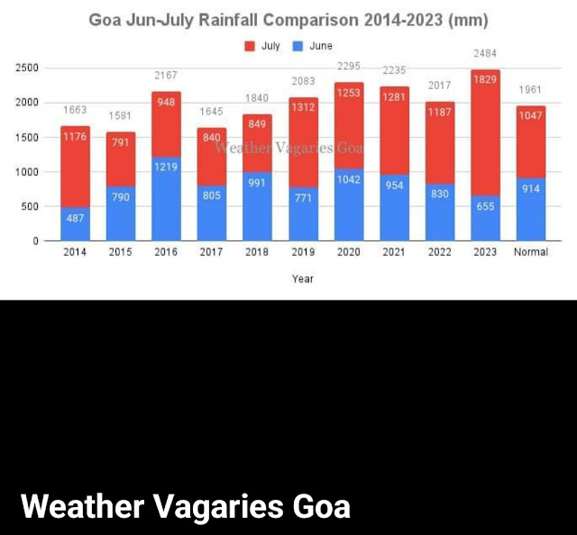
Goa SWM Seasonal rainfall is now 27% excess as on July 31!

Total rainfall so far is 2484 mm (98"), which is nearly 83% of normal seasonal rainfall (3008 mm), with two months still to go!

The July 2023 rains are the highest in atleast last 10 years, when Weather Vagaries Goa began keeping records.

As per climatology Goa receives 65% rains in Jun-July and 35% rains in Aug-Sept.

However a long Monsoon break is expected in August and it is highly likely that Goa will receive deficient rains in August.

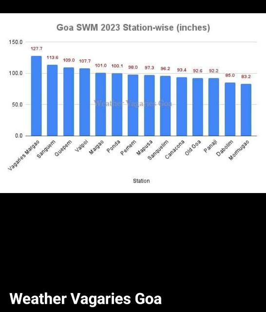
Top three wettest IMD stations so far are:

Sanguem: 114"

Quepem: 109"

Valpoi: 108"

Weather Vagaries Goa's Weather Station at Aquem Margao: 128".😊


(Daily Rainfall graph courtesy IMD Goa Centre)

Top 5 heaviest rainfall stations from Maharashtra state since 1st June 2023 till 31st July 2023:


1. Patgaon: 5000mm

2. Amboli: 4860mm

3. Tamhini: 4578mm 

4. Davdi: 4344

5. Matheran: 4153mm


Mahabaleshwar: Seasonal total 3855 mms( fyi).

----------------------------------

Mumbai Rainfall this year:

Monsoon though arrived a bit late, progressed  very well in Mumbai during both June and July, with 2319 mm of rain ( Scruz).

Rains totaled 549.1 mm  ( Scruz) in June, exceeding the monthly average. 

The annual rainfall in Mumbai is 2502 mm, and it has already received 2319 mm in June and July. Before the season ends, the city will exceed both the annual and seasonal

Seasonal totals 

Santacruz: 2319 mms. ..Full season normal till Monsoon end 2502 mms. Thus 92% of Seasonal rain received.

July rain this year.. 1768 mms. July normal 920 mms mms. Thus 191% of monthly average. 

Colaba: 1757 mms ...Full season normal till Monsoon end 2180 mms. Thus 80 % of seasonal rainfall received. 

Colaba  July this year..1333 mms. July normal 711mms. Thus 187% of monthly average. 

------------------

In a lighter vien: Only July rain in Scruz and the 2 month rain in Colaba is the same !

------

Mahabaleshwar: Seasonal total 3855 mms

July total :3105 mm

Saturday, July 29, 2023

Posted 29th Saturday Night. 

Mumbai:

Till 29th July Evening :

2304 mms Scruz total..92% of seasonal rainfall. In half time.

(Only July 1754 mms Scruz, Colaba 1324 mms.)

Mumbai Forecast...Outlook... 

30th Sunday, Monday & till Thursday 3rd August, will not see any more increase in rain frequency. Sporadic showers to continue with bright spells..Definitely relief for commuting.

Daily about 20  mms will show a compritvely drier week. 

Rains in " break phase" from 3rd August.

-------------------

Overall Outlook for next week: 30th & 31st July to 4th August 

From 3rd August, Monsoon enters into what is called a " Break Monsoon " phase.

The monsoon trough, after a prolonged " stay" South of normal position,  will move North. 

We expect the "break monsoon " phase for at least 8 days...common in August. 

Rains will decrease almost all over Central India, Gujarat and Peninsula India.  Good rains in Himalayan foothills from August 1st week. Flooding in Northern Plains. 

But no worries..this is needed, as the paddy fields now need a " sunshine break"


Friday, July 28, 2023

An informative get together at Pune on 28th Evening..

In attendance: Prof. R.R.Kelkar ( former D.G. of IMD, Senior scientists Sikandarji ( IMD), Senior scientists Mahapatra, Sabde,  ( IITM), Vagarians Abhijit, Abhishek, Gokul, Pavan, Nimish, Atul, Kapadia. 

Dr. Majumder of IITM ( virtual).


Thursday, July 27, 2023

Posted 27th Midnight 

Outlook : Mumbai rainfall will reduce from Friday, latest by noon, and Saturday will be getting sunny periods as explained. 

Now read 👇

Mumbai, North Konkan and Maharashtra Ghats have been lashed by heavy rains in the last 8 days.

Mumbai received as much as. 747 mms cumulative in 7 days : 21st - 27th.( July normal is 920 mms. July total this year 1668 mms).

Other Konkan Stations also had torrential downpour.

The good part was that all the rain in the ghats and coastal konkan was distributed equally on daily basis...meaning not 400 mms in a day ,which would result in flash floods. 

Reasons:

The Bay Low BB -5, though awaited. has and will behave stubbornly. With sticky Monsoon trough in South of normal position, and an over actvated over enthusiastic off sore trough, the system low crossed coast near N.Andhra.

Resulting in rains reduction in Mumbai and Konkan. 


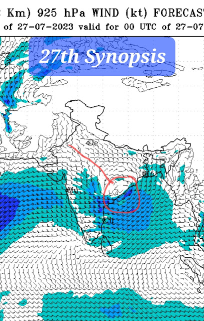
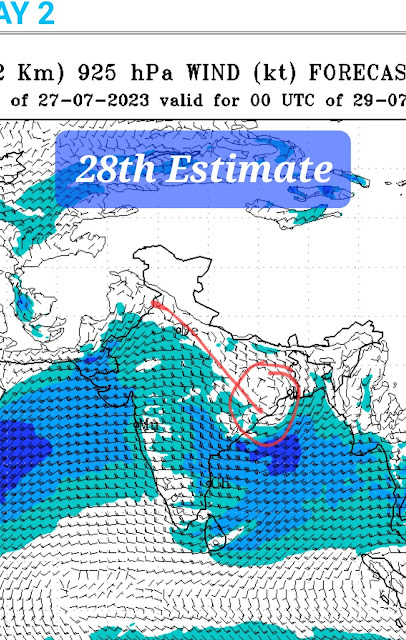
Now, from Friday 28th, due to W.D. circulation (CC), and the trough axis moving North rapidly, the low BB 5 will track North...a bit unusual.**

** This will bring about "Break Monsoon " condition. Break in rain intensity in Maharashtra, Gujarat and Peninsula from 3rd August.

Break monsoon is Normal for August. Can last from 4 days to 15 days. We feel the coming Break monsoon will be around 10 days...3rd to 13th August. 


 The why and how of the week long rains in Mumbai and Konkan 

At 11.45 pm ist Thursday 

27th July...2023 :
Telangana Special...

Heavy rains, under the influence of a new low pressure  ( BB5) area over Bay of Bengal, lashed Telangana  on Wednesday. System will weaken and track ( unusually) NNW...

Breaking Weather Update: 
Now it's Telangana !!

The latest Rainfall Data for Telangana 
reveals record-breaking figures! 
(Mulugu leads with a staggering 649.8mm)*


 Chityal Tahsil office in Jayashankar
Bhupalapally district recorded the
highest rainfall of 616.5 mm while
_axmidevipeta in Mulugu district
received 533.5 mm rainfall in the last 24
hours, according to Telangana State
Development Planning Society

According to TSDPS, the previous 
highest amount rainfall received by
any place in Telangana in 24 hours,
Was 51.75 cm at Wazeed in Mulugu
district on July 19, 2013, followed by
50.36 cm at Dahegaon in Kumuram
Bheem Asifabad district on July 23,
2013.


Wednesday, July 26, 2023


 26th July..Mumbai:

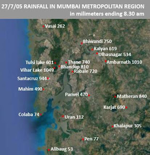
A day to remember..(see rainfall map of 26-07-2005 below)

2023 July...Mumbai Scruz July rainfall measured 1512 mms, ( Till 5.30 PM) making it the wettest July ever...beating the 1503 mms of 2020.

Amidst all doubts, of a poor Monsoon, the begining of Mumbai monsoon is good.

Infact, with "normal monsoon " Rains last 4 days..like 

Scruz: 23rd: 49 mms, 24th: 101 mms, 25th : 56 mms, 26th: 86 mms

Colaba: 23rd: 35 mms,  24th: 45 mms 25th: 28 ms : 26th: 45 mms

Scruz IMD touched a season's rainfall of 2000 mms on 26th afternoon!..2015 mms at 2.30 pm

It is the 2nd fastest season' 2000 mms ever (As per Vagaries records)..

1. 2021...22nd July...in 52 days

2. 2023...26th July....in 56 days

3. 1965...30th July....in 60 days

4. 2005....31st July....in 61 day

2005 map only for information 👆

‐--------------------------

But..we are not very optimistic about August 

Recollection of vagaries' Monsoon Watch published on 16th May 2023👇


Tuesday, July 25, 2023

Posted 25th July Night

Top 3 heaviest rainfall stations from Maharashtra ghats with seasonal totals (ending 8:30am on 25/07/2023):

🥇Amboli: 4030mm

🥈Patgaon: 3960mm

🥉Tamhini: 3812mm

Data Credits: IMD & Flood Control Dept

 The Mumbai lakes and dams level reported at 6 am on 25th July 2023 is  (726286 ML) 55% of the total Storage.

Last year on 25th July 2022 was 89 % of the total Storage


Sunday, July 23, 2023

Outlook for week 24th to 27th Thursday:

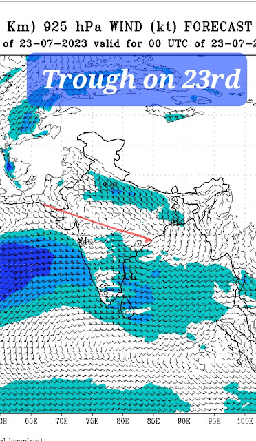
As the Monsoon trough starts moving towards North, extreme heavy rains will decrease from Gujarat, Konkan and Maharashtra Ghat Stations. 

Mumbai : Much of the week will see normal monsoon showers. Occasional heavy. No excessive rainfall threat.

Pune: Light showers in parts of Pune.  Next week around 70-10 mms of rain daily. Days around 26°c.

South Madhya Maharashtra ( Satara, Sangli,Kolhapur), South Konkan and Goa will see increasing heavy rains on 26th .

Marathwada, Vidarbha: Normal moderate rainfall, monsoonal rains.

Sambhajinagar around 10 mms daily with uniform distribution.

Definitely decreasing rainfall in Gujarat from 25th...and scarce rain in Kutch. 


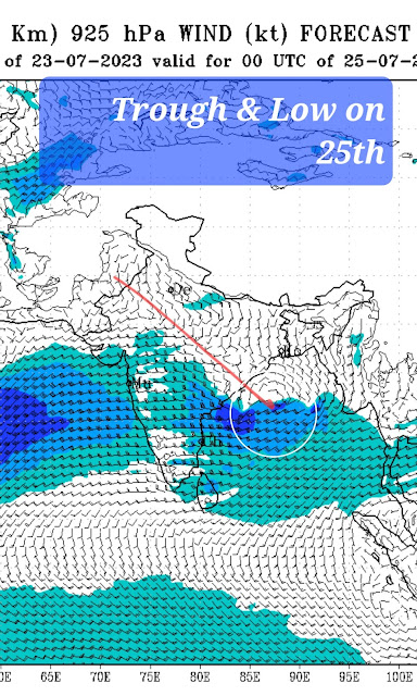
As the trough moves North. Low pressure BB 5 tracks along the trough from 27th...Resulting in Heavy rains with extreme falls possible in Punjab,  Haryana,Delhi, West U.P, and Uttarakhand.

Record Rains in Gujarat

 23rd July...

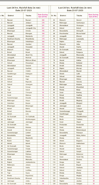
Record, Extreme and devastating rains in Junagadh and Kutch...

A basically low rainfall region!

Videos sent by Vagarian Gaurav ( Junagadh).


Excerpt from Vag. Gaurav 👇

"22 july 2023, it's Second time in july month when extreme rainfall event occurred and this time Historical flood create havoc in junagadh city of saurashtra (guj) 

, situation became horrific after 241mm cloudburst rains reported here today afternoon within few hours, and probably even more intense rains recorded in girnar mountain area which triggered flash flood towards city area, many vehicles and cattle washed away in flood water. Flood water entered Many residential societies and also in market area, local authority and NDRF attend rescue operation in flood affected areas."


Friday, July 21, 2023


TOP 5 BMC IN CITY AND SUBURBS RAINFALL AMOUNTS IN millimeters

12 HOURS (FROM 8.30AM TO 8.30PM ON 21/7/23)*

Colaba IMD  93 mm


Colaba pumping station 101

Municipal Head Office 99

Swd Workshop Dadar 94

F North Ward Office (Kings circle) 90

Rawali Camp 86


Vikhroli Fire Station 136

Marol Fire Station 131

Scruz IMD 120 mms

Chembur Fire Station 119

M East Ward Office (Govandi) 107

Bandra Fire Station 102 

-----------------------------

Snippet ...21st July 2.30 pm IST

Mumbai has already received 937 mm of rain, more than the usual amount for this month. It has been raining with different intensities continuously throughout July.

Why today on Friday  ?In simple terms :

The result of  system over North Konkan,  which refused to fizzle out ( as we expected today) and the fresh low coming from Bay have formed a trough line.This trough is shifting southward direction and getting close to Mumbai.

Rains for today and probably more tomorrow. 

Weekend forecast from Friday 21st to Sunday 23rd July: 

Rains to remain active across Maharashtra, Gujarat, Goa, coastal Karnataka and Himalayas!

Mumbai:
Seasonal Rains till today: SCruz 1488 mms ( 59.5") : excess by 351 mms till date. 
Colaba 1140 mms  ( 46"): excess by 75 mms.
Moderate showers expected on Friday with average 40-50 mm per day. 

Rains cannot stop completely!

After a " small respite ", some increase in rainfall possible on Saturday/Sunday. 
Usual low-lying areas may see temporary water logging, no major alert. 

Thane and Palghar districts may see some heavier rain (above 120 mm possible in some areas). 
There is a good chance of some heavy rainfall in Mumbai's water-supplying lakes region.

Localized places in Palghar district may get even heavier rain (maybe 200 mm or more). 

Pune: Reduction in rain on Friday 21st, but may pick up on weekend with some moderate showers - upto 20-30 mm over the weekend. 

Madhya Maharashtra: Northern districts like Jalgaon, Dhule, Nandurbar may receive some moderate to heavy rain over the next 2-3 days. Ahmednagar region (outside Ghats) can get moderate showers in some northern parts over the weekend. 


Marathwada: Expecting some moderate to heavy rains in Sambhajinagar, Jalna, Hingoli, Parbhani, Nanded, Beed districts. Other regions in Marathwada can also receive moderate showers. 

Vidarbha: Moderate to heavy rains likley in parts of Nagpur, Akola, Amravati, Buldhana districts. 

Goa: Moderate to heavy rains continue over the weekend (40-80 mm per day). 


Coastal Karnataka: Moderate to heavy showers to continue. 

Parts of Belgaum, Dharward belt to also receive moderate rain. 

Reasoning 👇 

BB-4 low which is remaining over Odisha region will move west towards Gujarat. Westerlies from Arabian Sea continue to provide moisture. 


A shear zone may persist at 700 hPa along Dahanu/south Gujarat into parts of Nashik/Dhule districts of Maharashtra, which can cause localized very heavy rain for parts of Palghar district or south Gujarat region. 


Gujarat: Expecting moderate to heavy rainfall in Baroda, Ahmedabad, Bharuch regions. Valsad and Surat regions to also receive heavy rain. Parts of Saurashtra can also get heavy rain over the weekend - some places can get above 150 mm in 24 hours. Moderate showers for parts of Kutch. 


Himalayan belt of Jammu, Kashmir, Himachal Pradesh, Uttarakhand and Nepal will continue getting moderate rain/thundershowers, with localized heavy rain. 

Instances of flash flood, mudslides/landslides may occur in few regions in Himalayas. 


Thursday, July 20, 2023

Season's Rainfall from 1st June _ 20th July.
Mumbai: Scruz 1458 mms
Colaba 1119 mms

Goa (Panjim) 1781 mms

Hill Stations in Maharashtra
1)Tamini: 2880 mms
2).Amboli 2774 mm
3) Matheran 2710 mms
         4.)Mahabaleshwar 2325 mms
5.)Khandala  2190 mms 

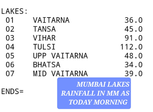
Mumbai Lakes: Rainfall & (Storage%)
1.) Upper Vaitarna 948mms,  (15%)
2.) Modak Sagar 1490 mm (63%)
3.) M.Vaitarna 1049 mms (50%)
4)Tansa 1179 mms ( 71%)
5) Bhatsa 1077 mms (32%)
6).Vihar 1373 mms (63%)
7)Tulsi 1959 mms (100%)
Total Storage 39.6%


Mumbai rains will decrease by late Thursday (20th) afternoon...NO ALERTS for rest of day.

Wednesday, July 19, 2023

 19th July:

Gujarat rainfall 


TOP 5 BMC IN CITY AND SUBURBS RAINFALL AMOUNTS IN millimeters

*12 HOURS (FROM 5.30AM TO 5.30PM ON 19/7/23)*


CITY

Britania storm water pumping 96

B Ward Office 86

Municipal Head Office and Malbar hill 84

Colaba Pumping Station 83

Frosberry Reserviour 82


SUBURBS 

Kandivali Fire Station 78

Dahisar and Mulund Fire Station 69

R Central Office 62

Kandivali Workshop 60

Borivali Fire Station 57

Colaba 98 mms last 24 hrs...total 1032 mms..enters +ve  zone. Scruz 53 mms last 24 hrs.

Tuesday, July 18, 2023

Forecast update for Mumbai/Pune/Konkan from today 18th till Thursday 20th July:
Next 2/3 Days:

Mumbai:

Frequent Heavy rain likely for Mumbai region with daily average rainfall around 70-120 mm. Low lying vulnerable areas may see some waterlogging.

Some areas can see higher amounts as well.

Entire Konkan belt to see heavy rains.

Ghats also likley to get heavy to very heavy rain. Good for lakes and dams.

Pune: Rain intensity likely to increase. Moderate showers likely in and around Pune city. Cool and pleasant weather.

Last 24 hrs Rainfall 
Mumbai Scruz 120 mms, Colaba 106 mms.
Ghats: 
Khopoli 215 mm
Lonavala 208 mms
Jor 196 mms.
Amboli 184 mms
Mahabaleshwar 176 mms
Matheran 170 mms

Kitwade 133 mms

Moderate rain likely for
Nashik, Satara, Kolhapur, Jalgaon districts. 

Sunday, July 16, 2023

Mumbai 

Monday 17th Tue /18th Wed 19th /Thur 20th:  

* Wetter than the previous weekend. ( 4 days Cumulative around 75-100 mms ),

*Intermittent Showers and periods of heavy rain. 

*No consistent rain showers to cause serious flooding.

Pune

* A wetter week ahead. ( 4 days Cumulative around 30-40 mms )..

* Frequent light patchy rain showers in different areas.

* Much cooler days at 25/26c.

---------------------------------------------------------------------------------------------------------------------


Encouraging Good News 👆... Normal Rainfall as on 16th.

More Rainfall Next Week 

👇Low Pressure BB-4 has moved into Odisha and expected to track Westwards into Central India.

Bringing copious rainfall into Odisha, Chattisgarh  .  >Vidarbh, East M.P. ( 18th) >. West M.P. and > .Gujarat Region  (19th) > Gujarat and Kutch (20th).

Sambhajinagar( Aurangabad): Very heavy thundershowers expected on 19th. ( 40-60 mms). Heavy showers may create flowing water drainage in fields. But farmers to take extra precautions for this.

संभाजीनगर(औरंगाबाद): १९ तारखेला मेघगर्जनेसह जोरदार पाऊस अपेक्षित आहे. (40-60 मिमी). मुसळधार पावसामुळे शेतात पाणी वाहू शकते. मात्र यासाठी शेतकऱ्यांनी विशेष काळजी घ्यावी.
Current Picture of crops in Aurangabad district 👇(From Shamrao Sonne)

Bharuch: Heavy thunder showers expected on 19th & 20th.

Valsad: Very heavy thundershowers on 19th & 20th.

----------------------------------------------------------------------------------------------------------------


Hottest Places  in the World on 16th: 


Maharashtra toppers till 15th July 2023:

1.Patgaon:1941mm

2.Dajipur:1883mm

3.Tamhini: 1852mm

4.Ghatghar: 1824mm

5. Amboli : 1820 mm

-----------------------------

Matheran: 1675 mm

Mahabaleshwar: 1462 mms

Mumbai

Scruz: 1156 mm

Colaba 792 mm

Mawsynram: 4550 mms* ,( not confirmed)

Cherrapunji: 4470 mm

Saturday, July 15, 2023

Delhi rain this monsoon

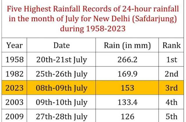
Delhi Safdarjung this season so far got 411.3mm rain (1 June - 15 July); out of this, a whopping 75% rain has fallen in just 3 days. This is in agreement with the recent monsoon pattern for north India which shows that the bulk of the monsoon rain is now occurring in a short time.

Delhi Safdarjung got 309.6mm rain in July so far. This is the third-highest July rain in Delhi since 2009 with still 16 days left for July.

Top3 wettest July in Delhi since 2009:

1. July 2021: 507.1mm

2. July 2013: 340.5mm

3. July 2023: 309.6mm (till 15 July)

The attached graph shows the daily rainfall variation in Delhi Safdarjung for this season till date. Data: IMD


 15th July...It's Vagaries Day..

Started 17 years ago to create a  platform for upcoming enthusiastic weather people...and having done so !

17 years of Weather Analysis, Weather Reports, Weather forecasting and interaction with meteorologists. 

Thanks to our Readers and followers for the faith in Vagaries. 

Thanks to IMS Pune and IMD for the recognition.


Friday, July 14, 2023

TOP 5 BMC IN CITY AND SUBURBS RAINFALL AMOUNTS

*In millimeters for 12 HOURS (FROM 5.30AM TO 5.30PM ON 14/7/23)*


*CITY* 

MUNICIPAL HEAD OFFICE 111

COLABA PUMPING STATION 101

B-WARD OFFICE (SANDHURST ROAD) 84

SWD WORKSHOP DADAR 78

MALABAR HILL 70


*SUBURBS*

BORIVALI FIRE STATION 90

DAHISAR AND MAROL FIRE STATION 86

K-WEST WARD OFFICE (ANDHERI W) 80

VIKHROLI FIRE STATION 74

GOREGAON 58

Compiled by Vag Tejas 

Posted Friday 14th Morning:

Mumbai: With Scruz recording 53 mms and Colaba 45 mms in last 24 hrs as on Friday morning, a sort of Monsoon revival is seen.

On and off showers for next 3-4 days, moderate to heavy. Daily average rain may be around 60-100 mm across the city. 

Pune: Some change in the weather, may get a bit rainier. Some light to moderate showers likely. 

Marathwada: Partly cloudy with some light rain in few regions.

Weather outlook from Friday 14th to Monday 17th July - Monsoon turning active for central India and parts of west coast.

Possibly Gujarat may see another good spell next week. 

A mid-level circulation is expected to develop near north Odisha and south West Bengal coast by 15th/16th July and travel west-northwest. It may possibly descend to form a low-pressure area at the surface. 


Heavy rain is likely in parts of Odisha, Chhattisgarh. Telangana and Vidarbha can get moderate-heavy rain

Madhya Pradesh to also receive moderate-heavy showers. 

West coast: Karnataka to north Konkan (Mumbai)/south Gujarat coastal regions may receive moderate rain with heavy in some places. 

Westerly winds from the Arabian Sea are not very strong, so Ghats may get some moderate-heavy rain (may not be widespread), but interior regions over the Deccan plateau may only receive light showers. 

Monsoon trough may pass near Delhi NCR region. So, some rain/thundershowers likely for Delhi NCR, north Rajasthan, parts of Haryana, Punjab and Uttar Pradesh. 


Gujarat: Some moderate rain likely for coastal areas like Valsad/Surat. Light to moderate rain for Bharuch region. Parts of Saurashtra may get some moderate rain.  

Thursday, July 13, 2023

 Posted 12th Evening.                     Mumbai 👉

Contrary to early estimates...👇

and 1.) West Coast rainfall to increase this weekend 

2.) More rainfall for central and Western India next week. 

Forecast coming here tomorrow 


Tuesday, July 11, 2023

Topic: "Climate Change"...various options to comprehend...😣😮

Few weeks ago, the headlines were: Are drought increasing due to climate change.

And now...headlines changed to: Extreme rain floods increasing due to climate change 😀

Confusing isn't it 😕?

"Is India heading for drought"..was harped upon last month...

We must understand that alone El-Nino cannot determine the fate of monsoon.

According to an analysis by Credit Ratings Agency CareEdge, there have been 21 El Nino years in India since 1950. The last El Nino was observed in 2018-19 during which India received below normal monsoon. The analysis shows that during 1969, 1976, 1977, 1994, 1997 and 2006, the country received normal rainfall despite them being El Nino years. 


Much was said earlier this year about Monsoon failure chances ..

Vagaries clarified in MW2 MW4 that initially we will get good rains...

Similar Hype was made for an "extreme Heat wave in India"...which never materialized.

Let's not Panic..But at the same time let's be Alert !

Monday, July 10, 2023

Forecast from Monday 10th to Wednesday 12th July: 

Mumbai: On and off passing showers to continue with sunny intervals. May get windy during the passing showers. Days getting warm to around 31C and sultry during sunny periods. Rain intensity may start increasing from/after 13th July.
 
Pune: Getting warmer with more frequent sunshine. Max temperature around 30-31C. Light shower/drizzles at times. Breeze can be cool and pleasant.

Marathwada: Sunny intervals, and days getting warmer up to 30-31C. Wednesday 12th July may see some light to moderate rain in Sambhajinagar district. 

मराठवाडा : ढगाळ वातावरण कमी, वाढत्या उन्हामुळे दिवस ३०-३१ सेल्सिअसपर्यंत उष्ण होत आहेत. बुधवार १२ जुलै रोजी संभाजीनगर जिल्ह्यात हलका ते मध्यम स्वरूपाचा पाऊस पडू शकतो. 

Vidarbha: Overall, less to no rain till Tuesday 11th July. Rain/thunderstorms may increase on Wednesday 12th July. 

Rain till Monday Morning:
Scruz 1044 mms (42"), Colaba: 659 mms( 26").
Cherrapunji 3560 mms (142"), Matheran 1483 mms (59") (9/7), Amboli 1385 mms (55")(9/7), Mahabaleshwar 1371mms (55"), Khandala 1138 mms (46"). 

Sunday, July 09, 2023

Posted 9th July ..👇


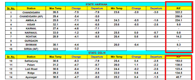
A strong Inter Action of Monsoon Trough and W.D. brought heaviest rainfall, unseen usually, in Himachal, Punjab, Chandigarh and Delhi

Chandigarh City measured 322 mms, A.P. 286 mms, in last 24hrs, (even thought he Maharashtra & Karnataka Ghats Stations are yet to see this in the current season.).

This is the highest ever 24 hrs recorded in Chandigarh City.

Readings as on 9th Morning...last 24 hrs.👇


Balachaur AWS recorded 268 mm

•Ropar AWS recorded 236 mm

•Ambala recorded 224 mm
Pathankot 151 mm
Ferozepur 111 mm This is a very extreme event for the Northern India plains.

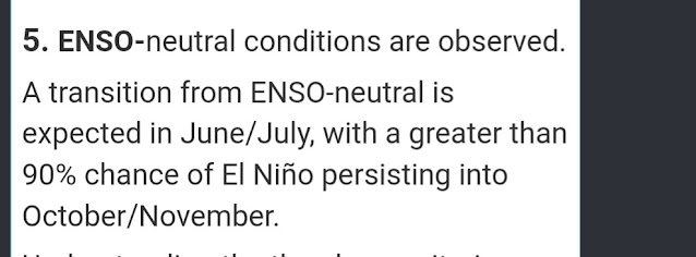
 13th September  Early Snowfall in Higher Reaches of Uttarakhand.  Latest on Enso ENSO ALERT SYSTEM:   El Niño or La Niña Watch:  Issued whe...