Friday, March 31, 2023

Godbunder Road👆 Mumbai on 31st...from Friend..credit Vag  Tejas
31st Morning:Some drizzles/light showers being reported in parts of Mumbai/Navi Mumbai, Thane and Palghar districts. 


Western Disturbance effect - strong trough in mid-latitude westerlies dipping south, cyclonic circulation north of Rajasthan, and lot of moisture transport.
Trough in 850 hPa also seen across east-central India. Some showers/thunderstorms likely in parts of Vidarbha region and along the trough line.


Wednesday, March 29, 2023

30th March Weather 👇


Weather outlook till Friday 31st March -

As we calculated in mid March after the Heat spell,  remaining days of March stayed below 40c in India...And this may continue for another week..as

Another Strong Western Disturbance with trough dipping south on the way!

Effects of the new WD will start from today onwards. 

Gujarat: Rain/thundershowers likely in Kutch and Saurashtra on today 29th and tomorrow 30th March. 

Ahmedabad region may get some patchy rain on 30th. 

Surat, Bharuch, Baroda may see some cloudiness, light showers may be possible in some areas on 30th and 31st. 

Maharashtra: Some clouds and patchy drizzle/light showers for north konkan, possibly reaching Ghats. 

Mumbai, Dahanu/Palghar, Thane regions may see some clouds with light showers (in some parts) around 31st March. Max temperature around 32-33C near coast, 34-35C in interior konkan, min around 22C.

Pune: Strong west breeze during 30th-31st, max/min around 35C/16C. 

Westerly winds can be strong on 30th and 31st March for entire western Maharashtra.

Light showers possible in some areas of Nashik, Nandurbar, Dhule, Jalgaon districts around 31st March.

Rajasthan and Punjab may get some rain/thunderstorms from today 29th onwards. Heaviest precipitation for northern plains, including Uttar Pradesh during 30-31st. 

Delhi NCR - Thunderstorms with chances of hail likely during 30th-31st March.

Rain/hail in low-mid ranges of Himalayas, snow in higher elevations from today 29th March - 1st April. 

East coast - The pre-monsoon/summer thunderstorms - 'Kalbaisakhis' likely for Odisha, West Bengal, Jharkhand and Chhattisgarh regions. Parts of coastal Andhra Pradesh to get some rain/thundershowers.


Still analysis of SWM data is being done, and will give our views on SWM soon.

Tuesday, March 28, 2023

 Indian Meteorological Society bestows a Special Award for major contribution in the field of Meteorology and Atmospheric Science to Rajesh Kapadia at IITM, Pune.


Saturday, March 25, 2023

 25th March Evening 

Let's Appreciate when the Air Quality is Good


 Severe " Tornado" in Fazilka District Punjab on 24th

Video sent by Navdeep Dahiya


Wednesday, March 22, 2023

 22nd March


Outlook till Friday 25th March:

Another strong Western Disturbance to affect the country with trough dipping South:

Mumbai: 23rd-24th...partly cloudy ⛅️ and chance of very light rain in some areas of city. Day humid around 33/34°c.

Pune: No rain..some clouds ,about 2 OKTA.  Warm at 33c..nights around 22/23°.

Gujarat: Rain/thunderstorms with chance of hails likely tomorrow 23rd March across Saurashtra and Kutch. Ahmedabad region may get a few showers on 23rd/24th.

Light showers likley along Coastal Gujarat (Surat/Navsari/Bharuch) and very light showers parts of North Konkan (Dahanu, Palghar, Mumbai, Thane) on 23rd/24th March. 

Punjab and north Rajasthan to see rain/thunderstorms during 23rd-25th March. 

Haryana, Delhi NCR, west Uttar Pradesh, north MP and remaining areas of Rajasthan can see thunderstorms during 24th-25th March.

Himalayan states and Union territories will see moderate to heavy rain/thunderstorms in low-mid ranges and snow over higher elevations.

Tuesday, March 21, 2023

Posted on 21st March Morning

21st Maharashtra Days..much below normal 


Mumbai:

Santa Cruz : Rain today 16.9 mms...And Monthly also is 16.9mms.{This is the highest ever days rain and total for March (Previous highest was 11.9 mms on 10th March 2006 with 13.1 mms as March total in 2206.}

Colaba: Recorded 25.4 mms of rain. {However the all time record for March is 37.1 mms in 1918.}

Minimum at Colaba was 20.6c (2.6c below normal)


Strong incursion of Westerlies upto upper levels of atmosphere

causing rainfall ...and weak upper level trough around North Konkan.

Surprise early morning thundershowers lashed Mumbai Metropolitan Region on 21/03/2023! Below are some figures ending at 9am in mm:

1. Koparkhairane: 41

2. Memonwada: 38

3. Vashi: 39

4. Mumbai Central: 35

5. Bhendi Bazaar: 34

6. Pawne & Mumbra: 33

7. Sanpada: 32

8. Byculla & Malabar Hill: 31

9. Aadharwadi & Grant Road: 30

10. Marine Lines: 27

11. Kopri: 26

12. Sion, Colaba IMD & Grant Road: 25

13. Vagaries Club & Elphinstone Road: 24

14. Bhatan Tunnel (Expressway) & CSMT: 23

15. Dahisar, Virar & Matheran: 22

16. Dadar East: 21

17. Panvel & Vile Parle: 20

18. Airoli & Nerul: 19

19. Belapur, Haji Ali & Powai: 18

20. Santacruz IMD & Nariman Point: 17

21. Andheri & Sakinaka: 16

22. Naupada: 15

23. Malad & Worli: 14

24. Bandra: 13

25. Kandivali: 12

26. Jogeshwari: 7

27. Goregaon: 8

28. Borivali: 5

29. Dombivli: 3


Data Credits: MCGM, IITM & IMD

Compiled By: Vagarian Abhishek Apte

Sunday, March 19, 2023

20th March...Mumbai Air Quality..Good now.

 ..Green =Good

Safar..Morning 

Air Quality..Afternoon...Yellow = Moderate ( Not Severe)


-----------------------------------------------------------


19th March...

Mumbai not polluted now...everything imroves..so no panic reactions 


Noticeable Lows today in Maharashtra:

Mahabaleshwar  12.4° ( -6)

Sambhajinagar ( Aurangabad) 12.4° (-7)

Nashik 14.5°

Pune 15.0°

Colaba 24.2°

Santacruz 22.8•

Wednesday, March 15, 2023

 Scenario as on 15th Wednesday Evening 

Check the difference in clouds type in blue abd red circle 


And  Pune & Mumbai Skew Radiosondes 


Tuesday, March 14, 2023

Vagaries of the Weather...is not an unusual phenomena...

It is seen that the cyclic variations occur over the years . This can be attributed to the various weather parameters  happening from meteorological events in certain periods of time.

Cyclic rotations are repetitive over the years. 

In Europe, currently, there is a freezing extended winter and most unusual cold snowfall in California. 

India saw the hottest February ever.


An early ( temporary) beginning to March 2023 with high temperatures and lack of winter ( WDs) systems. 


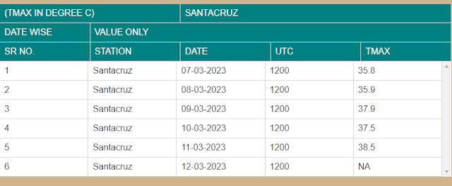
Mumbai saw hot weather for an unprecedented 8 days at a stretch with daytime temperatures 6c above the normal.

Expecting Mumbai to see some light thundershowers from 15th, and better day temperatures around 34/35°c.

We write ( temporary) as the heat waves in the Sub Continent is about to wane.

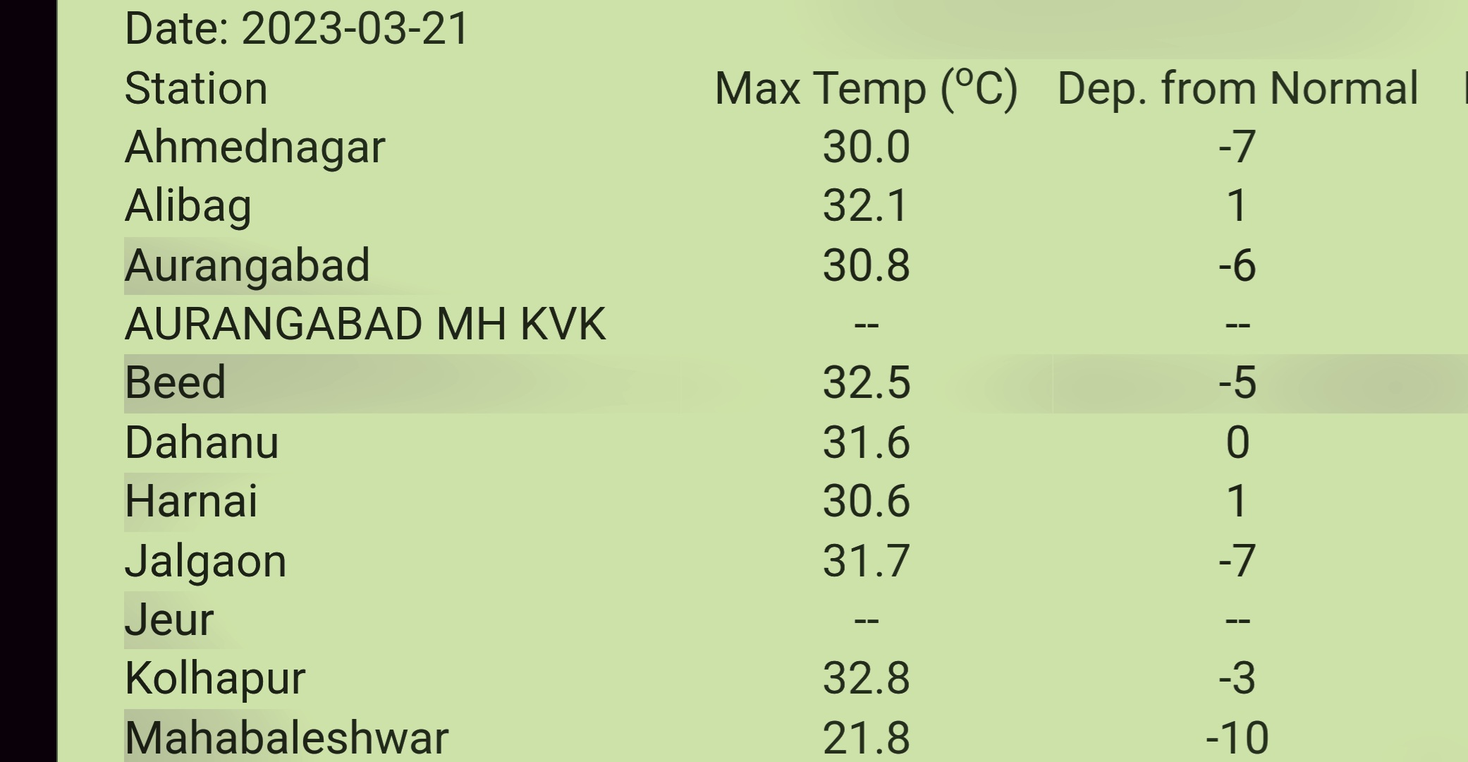
We do not expect any place in India to touch even 40c ,at least for the next 10 days into March.

All theories will vanish, as Nature first heated the Land, and consequently formes a Low pressure trough in Central India by Mid March. 

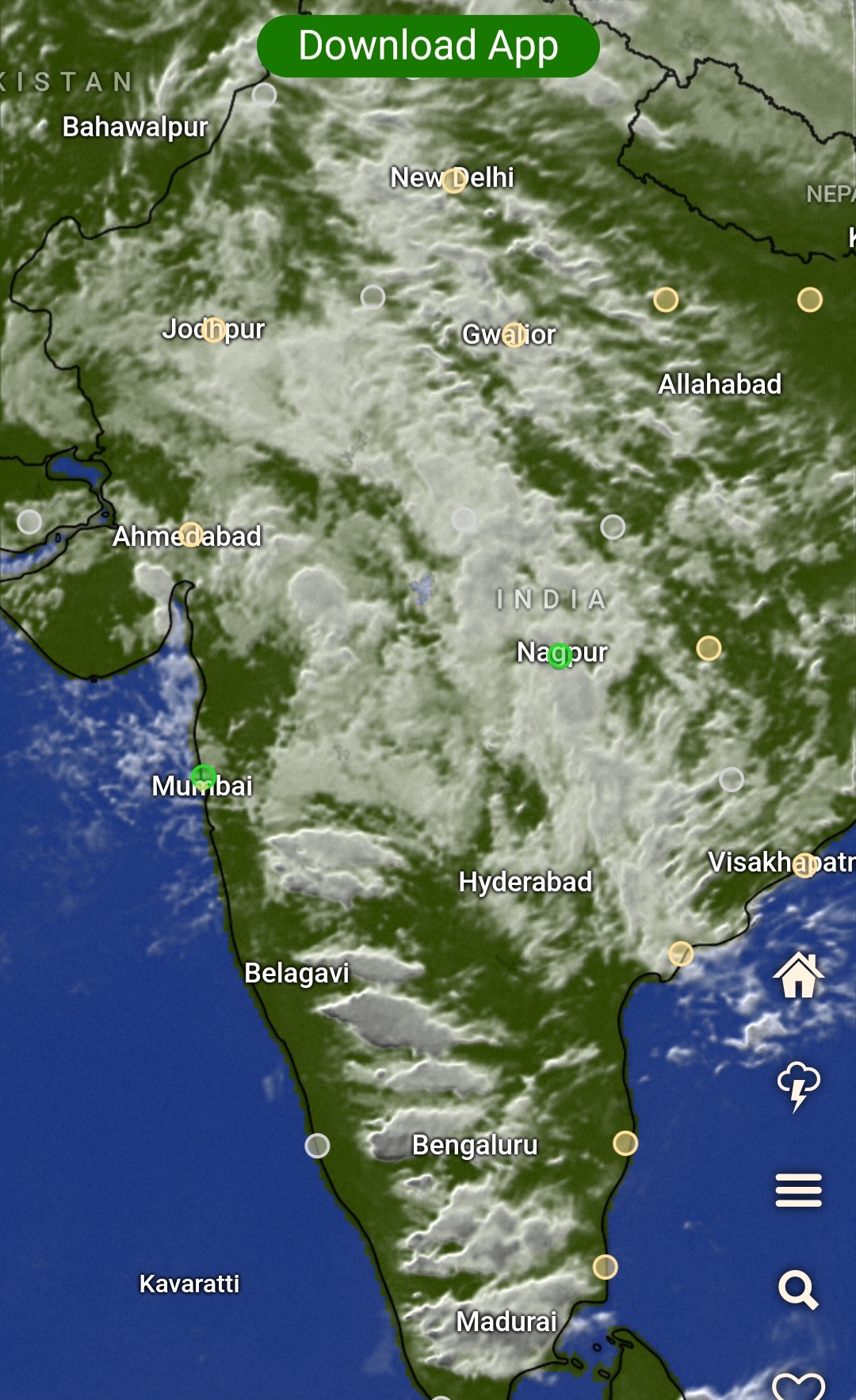
Early Pre Monsoon Showers expected..  Thundershowers with rain and hail is expected all over 

1. Central India ( EastRajasthan , M.P, Chhattisgarh,  parts of Haryana &U.P, Jharkhand. 

2. Peninsula India ( Maharashtra  Gujarat, Karnataka, Telangana).

3. Parts of Southern States. 

‐----------------------------------------------------------

Outlook: for 14th -20th March 

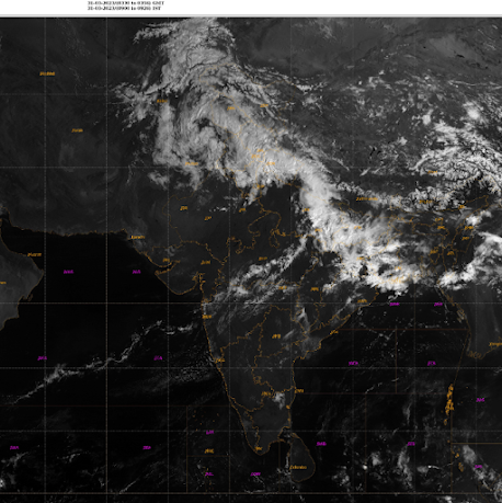
A wet spell of pre-monsoon rains is likely across the country - beginning tomorrow 14th March, and likely extending to 20th March!

Reasons:

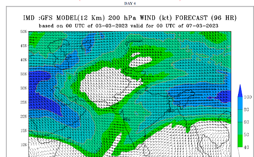
- Strong Western Disturbance due to dip in Westerly Jet Stream at 200 hPa

- Trough of low and wind convergence in lower levels across peninsular India

- Lots of moisture pulled in from Arabian Sea and Bay of Bengal 

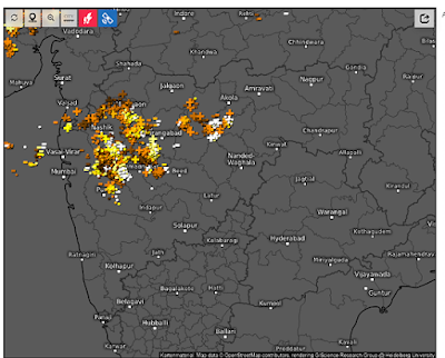
Thunderstorms with chance of hail likley across Maharashtra, Madhya Pradesh and western parts of Karnataka and Kerala starting from 14th March. 

15th-17th March to see the most widespread thunderstorms across the interior peninsula including Telangana, Andhra Pradesh and Tamil Nadu. 

Parts of Gujarat, Rajasthan, Uttar Pradesh, Chhattisgarh, Odisha, Jharkhand, Bihar and West Bengal to see thundershowers during the next 7 days. 

Outlook prepared by Vagarian Shreyas. 


Sunday, March 12, 2023

Posted 12th March Afternoon:

Mumbai:

Its been hot and very hot last 10 days for Mumbai. With above normal temperatures to the extent of upto 6c above the average. The last 6 days..showing the trend.👇

Well, all this was attributed to the dominating Easterly winds, which constantly kept the Westerly sea winds at bay. Even the North winds , which could have provided relief, but were missing due to absence of Western Disturbances in the North. 

Now, with a Trough of Low pressure developing in the Interior Maharashtra region, the hot easterlies will cease to blow over Mumbai, and ....

From Tuesday 14th, Mumbai will see the days getting better at 34/35c..Much better then the high 30s. But, the sweat factor may increase, as the sea winds can increase the humidity levels..Light drizzle possible in some areas of city on 16th.

So, after 14th, for the week upto 17th, Mumbai will see around 34/35c in the day and partly cloudy skies. 

Interior Maharshtra  regions like Madhya Maharashtra, Marathwda  and Vidharbh can get showers and hail.

Heavy rains and hail possible in Sambhajinagar ( Aurangabad) and Marathwada on 15th/16th. Warning to farmers to take due precautions to cover the crops after thrashing.

15/16 रोजी संभाजीनगर (औरंगाबाद) आणि मराठवाड्यात पाऊस आणि गारपीट होण्याची शक्यता आहे. पीक कापणीनंतर झाकण्यासाठी योग्य ती खबरदारी घेण्याचा इशारा शेतकऱ्यांना

Pune can expect light showers on 15th/16th.

These showers in the interior are actually "advance  pre monsoon showers". The trough in the Interior Maharshtra and South M.P. region cause the moisture from the Bay and Arabian Sea to converge in the Central Peninsula.

Threatening MJO

Dr.Vineet's analysis ...More on his page

First time ever in history MJO line has gone out of the boudarylimits  of this plot


In terms of amplitude wise, it is third highest, just trailing behind 2015.

Important thing to note 2015 when such an amplitude of mjo was observed , very strong elnino followed

Friday, March 10, 2023

9th March:

El Nino and The South West Monsoon...Instead of going into panic mode, let us first understand the  current phase and possibility of an "El Nino" situation.  

El-Nino:

El Niño refers to a warming of the central and eastern tropical Pacific Ocean that can have compounded effects on global weather patterns. El Niño events can have significant impacts on the SouthWest monsoon.


But, there is no one-to-one direct effect between El Niño and the Indian summer monsoon. The quantum of impact may vary depending on the strength and timing of the El Nino event.

Overall in history.👇
Data from 1951 shows there were 15 moderate and strong El Nino events between 1951 and 2022.

As per information form records, In this period, the Indian monsoon was deficient (-10%) in 8 years and in another 3 years the monsoon rainfall was on the lower side of the norm ( -5% to -10%).

-------------------------------------------------------------

Technical Explanatory Note of Latest Scenario:

* La Niña has ended and ENSO-neutral conditions are expected to continue through the Northern Hemisphere spring (March/April)and early summer 2023.(May/June)(as per CPC)

*Equatorial sea surface temperatures (SSTs) are below average across most of the Pacific Ocean. 

*Niño 3.4 -0.2ºC

*The tropical Pacific atmosphere is consistent with La Niña. ENSO-neutral conditions are expected to begin within the next couple of months, and persist through the Northern Hemisphere spring and early summer.

**The ONI is based on SST departures from average in the Niño 3.4 region, and is a principal measure for monitoring, assessing, and predicting ENSO. Defined as the three-month running-mean SST departures in the Niño 3.4 region.

 El Niño: characterized by a positive ONI greater than or equal to +0.5ºC. La Niña: characterized by a negative ONI less than or equal to -0.5ºC. By historical standards, to be classified as a full-fledged El Niño or La Niña episode, these thresholds must be exceeded for a period of at least 5 consecutive overlapping 3-month seasons. 

(CPC considers El Niño or La Niña conditions to occur when the monthly Niño3.4 OISST departures meet or exceed +/- 0.5ºC along with consistent atmospheric features. These anomalies must also be forecasted to persist for 3 consecutive months.)


The most recent ONI value (December 2022 – February 2023) is -0.7ºC.

Excerpts from National Oceanic and Atmospheric Administration (NOAA)

-------------------------------------------------------------

Expected Position Explanation:(As per Vagaries)


A perfect forecast of El Nino and how it will impact the South West monsoon will be seen only by May-June. Besides El Nino, there are other factors too influencing monsoons. 

So, the earliest that an initial El Nino can be called as "setting" is in June/July 2023. 

But we should  now expect an full fledged El Nino event by August-September.

Let's be Alert rather than confused.


Thursday, March 09, 2023

 White  Holi  for UK 🇬🇧 ..World Weather Page Updated 

Dr Vineet's Page Updated 

Posted 9th March Morning 

Mumbai witnessed "The Vagaries of the Weather "

It has been a tough 1st week of March for Mumbai ..Dust factor high with AQI touching an astonishing 325...Above normal heat at 38/39c, unusual for Mumbai with 35-40% humidity....and pounding thunder with light showers..and the ( most unusual) occasional hail !

Mumbai Temperatures behavior last few days 


----------------------------

Things may not see a major improvement this weekend..9th to 12th.

We expect Mumbai to heat up to 38c again by Saturday/Sunday...but no rain of course. A dazzling hot 🔥 sun with dusty atmosphere..AQI could be around 300.

The blowing easterlies will keep the air dusty aided by the local conditions.

Warm stuffy at nights, as we do not expect nights to fall below 24c.

Interior Konkan could heat up to 40c.

Pune and Sambhajinagar (Aurangabad) will remain dry and around 36c in the day.

‐---------------------------

Vagaries had prepared the Marathwada and farmers about the chances of  unsesonal showers and hail..to save their standing crops...and we received their blessings as below 👇


-----------------------------------------
Gujarat:

Days to get hotter...max temperature in the range of 36-38°C in most places including Ahmedabad, Baroda, Bharuch as well as Saurashtra and Kutch. 

Min will be around 20-22°C. Dry weather for next 4-5 days

Wednesday, March 08, 2023

 Cool drizzling Holi day in Sambhajinagar ( Aurangabad) on Tuesday 7th  .Day at 25c (-10c) and night  at 9.7c (-8c).

Tuesday, March 07, 2023

 FAQ

Latest on Air Quality Index at 2.30 pm Tuesday  ..Holi..7th

Delhi👇


Kolkata 👇


Pune 👆


Mumbai 👇


Monday, March 06, 2023

6th March:

Hottest In India today...Mumbai Santa Cruz at 39.3c...well, seems to be rising without any brakes  


Vagaries Private station recorded 39.7c...


But the evening winds and clouds will hopefully drop the day temperatures tomorrow by 2/3c with some rain.

Wind gusts at Santacruz were 46 kmph and winds at Colaba were 45-50 kmph.Colaba 37.0c.

Our First Video Presentation:


Lightning in Gujarat and Maharashtra Monday Evening


 6th March....Thunder Showers strip across North Mumbai on Monday Pre Dawn...

Vasai measured 2.2 mms

Sambhajjinagar (Aurangabad) saw 0.4 mms.

Sunday, March 05, 2023

Posted Sunday 5th March:

Mumbai Hottest in State today...

Mumbai Santa Cruz recorded the Highest reading of this season by measuring 38.1c on Sunday 5th .(It overtakes the 37.9c of 18th February this year.)

The rise in the last 6 days...👇

(TMAX IN DEGREE C)SANTACRUZ
DATE WISEVALUE WITH NORMAL & DEPARTURE
SR NO.STATIONDATEUTCTMAXNORMALDEPARTURE
1Santacruz28-02-2023120033.932.41.5
2Santacruz01-03-2023120033.532.41.1
3Santacruz02-03-2023120035.532.92.6
4Santacruz03-03-2023120035.532.92.6
5Santacruz04-03-2023120037.032.94.1
6Santacruz05-03-2023120038.132.95.2
right scroll shows departure from normal

(However,No panic, as far from the all time March record of 41.7c at Santacruz in 1956.

In the last 10 years, Scruz has crossed has crossed 40c in March 6 times. (2022 hottest March day was 39.6c 0n 14th.)

Colaba Station also maintained its streak by recording 36.2c...again far from its March record of 40.4c in 1981.

Mumbai is placed 7th Hottest City in India today..Hottest being Karwar (Karnataka) at 40.2c.

Cloudy and stuffy weather to continue...with a light drizzle adding to the discomfort.😕

Some maximum temperatures recorded on 4th March 2023:

Gujarat

Rajkot 39.3ºC 

Porbandar 37.9ºC 

Surat 38.2ºC 

Baroda 38.6ºC 

Bhavnagar 37.3ºC 

Valsad 39.1ºC 

Ahmedabad 38.2ºC 


Maharashtra

Mumbai Scz 37ºC 

Mumbai Clb 34.7ºC 

Pune (Shivajinagar) 35.2ºC 

Nashik 35.6ºC 

Ratnagiri 35.9ºC 


Karnataka - coastal areas seeing very hot weather

Karwar 40.2ºC 

Gokarna 40.2ºC 

Mangalore 36.6ºC 


Saturday, March 04, 2023

High temperature in Goa

Panjim recorded 37.8C on 3 March which is 5C above normal and is the highest temperature recorded there in March after 2013.


Today 4th till Monday 6th March - Parts of Saurashtra and Gujarat region (Ahmedabad, Vadodara, Bhavnagar) can get some thundershowers in patches

Friday, March 03, 2023

Off Seasonal Rainfall , Light to Moderate Expected in Western Maharashtra and Mumbai from 5th - 9th March.

Mumbai: Next week, expect a change...humidity ( 70-80%) and along with partly cloudy , sticky weather. ☔

Warm nights and possibly light rains in some parts of Mumbai on 7th/8th. 

Pune: Next week, (6th to 9th) , warm nights 18-20c, and cloudy. Light rains with some distant lightning in parts of Pune. Humidity also to be more .☔

Aurangabad : Next week, 6th to 9th,...As the weather gets cloudy, region can expect light to moderate rains in some areas. More rains on 8th. Take extra care of the harvested /standing wheat crops as hails may be expected.☔ 

औरंगाबाद : पुढील आठवड्यात, 6 ते 9,... हवामान ढगाळ झाल्याने काही भागात हलका ते मध्यम पाऊस पडण्याची शक्यता आहे. 8 रोजी आणखी पाऊस. कापणी केलेल्या/उभ्या असलेल्या गहू पिकांची अतिरिक्त काळजी घ्या कारण गारपीट अपेक्षित आहे.☔

Jalgaon: Next week, 5th to 9th, warm cloudy weather with night chill absent. Light rains expected on 6th/7th/8th. Maybe with hails.

Similar forecast of light rainfall for Akola and Nagpur.

I do not expect major damage to Mango fruits as rains may not be much.

Bharuch: Expected hot cloudy weather next week with light rains in some areas.

Change of weather for parts of Maharashtra and Madhya Pradesh this week...chances of thunderstorms!


We waited before issuing the forecast...as it is expected around 5th March onwards.


Forecast from 5th - 9th March:

Combination of:

 - A strong dip in westerly jet stream (mid-upper level westerly trough 500 - 200 hPa), 

 - Low level trough (850 hPa) in easterlies 

- Moisture from Arabian Sea and Bay of Bengal

may lead to thunderstorms forming in central and western parts of the country. 


The region highlighted in red can get thunderstorms.


Parts of north Maharashtra - Dhule, Nandurbar, Jalgaon, Nashik, Ch. Sambhaji Nagar, Ahmednagar, Akola may get rain/thunderstorms in patches. Some places may get hail. 

Parts of Pune district can also see some cloud build-up and light rain/thunderstorms during 6th-9th March. Rain belt may shift east to cover Jalna, Akola, Washim, and Amravati districts after 6th March. 

Mumbai and konkan - No major change in weather, but some increase in humidity is expected. 


Madhya Pradesh: Western parts of the state close to Gujarat, and cities like Indore, Bhopal, Khandwa can get thunderstorms with chance of hail from 5th March onwards. Rain belt may spread to cover eastern and northern parts of the state on 6th-7th March. 

Rajasthan: Light showers/thundershowers in western parts of the state tomorrow on 4th March. Eastern and southeastern parts of the state such as Jaipur, Udaipur, Kota can get thundershowers during 5th - 7th March. 


More details by weekend/early next week...

Reasons for heavy rainfall over UAE and parts of Oman  Clarification of some doubts, Vagaries briefly explains the reasons behind the recent...