
Mumbai Water/Lakes Position as on end May 2022
Live storage as at 6 am 30 May 2022
 Last Modified: 30-May-2022 6:30 PM
Monsoon still 13/15 days away !
Rainfall Totals of ⛆
Cherrapunji:
Mar/Apr/May/: 3880 mms......Jan - May: 3950 mms
Mawsynram :
Mar/Apr/May: 5151mms....Jan-May: 5550 mms..
Researchers Please read on Weather Knowledge Page -43..
29th May 2022
A)..IMD today, has advanced Monsoon into Kerala:
Justification:
>The strength of the westerly winds have increased over southeast Arabian Sea and is about 15-20kts (25-35kmph).
> Cloudiness over southeast Arabian Sea and adjoining areas of Kerala have increased and the average outgoing long wave radiation(OLR) is about 189.7 W/M2 (thus <200 W/M2 ).
B)..Vagaries would still wait for the SWM entry into Kerala...maybe in 1st Week of June.
Justification:
> Above IMD criteria are correct, but weak ,as
.png)
*

*

South West Monsoon will evade from Kerala Latitude till 4th June at least...Hence no further progress expected next 4/5 days...
-------------------------------------------------------------------------
Mumbai: Partly Cloudy, Humid and very stuffy. Real feel temperatures around 38c, even though the recorded will be around 34/35c....Light rainfall in patches in parts of city will add to the discomfort...No change till 5th June....Proper Monsoon not before 13th June.
Pune: Hot at 34/35c, with clouds forming after Noon..thundery developments after 1st June possible.
Goa: No direct Monsoon approach expected till 10th June...some scattered showers in parts only.
Marathwada: Will be dry and hot and temperatures around 38c. next 7 days...thunder clouds may develop after 4th June...Monsoon still not arriving before 13th at least ..Hold back sowing operations.
मराठवाडा: पुढील 7 दिवस कोरडे आणि उष्ण आणि तापमान 38 अंशाच्या आसपास राहील... 4 जूननंतर मेघगर्जनेचे ढग निर्माण होऊ शकतात... किमान 13 तारखेपूर्वी मान्सूनचे आगमन होणार नाही.. पेरणीची कामे थांबवा.Overall Maharashtra outlook till 1st June - Summer to continue, hot weather at most places!
With the recent strong WD trough disturbing the monsoon's northward progress and MJO entering unfavourable phases for Indian Ocean, it now seems that the monsoon ( In Maharashtra) may arrive at its normal average dates (and not before time).Monsoon onset seems to be significantly delayed from the forecast, no good rain are seen in Kerala at least till 4 June
Monsoon Dates Given below are likely dates.
Konkan: Warm and humid weather, with localized light shower at some places. No heavy rains anytime soon.
Monsoon expected (as of now)..south Konkan/Goa 9th/10th June. North Konkan (Mumbai ) 12th-13th June.
Madhya Maharashtra: Hot weather to continue. Patchy localised thunderstorm development possible towards month end. These will be pre-monsoon/summer thundershowers, not providing much relief. Monsoon South Madhya Mah: around 9th-10th June. North Madhya Mah 13th- 15th June.
Marathwada: Very hot and mainly dry weather expected. Advised to avoid sowing till around 15th June. Monsoon around 16th June.
Vidarbha: Very hot weather to continue. Some localized thundershowers likely in eastern parts of Vidarbha in next 2 days, but days will heat up after that. Avoid sowing till around 15th June. Monsoon around 15th-17th June.
With negative iod likely to dominate the indian ocean this season
I have a feeling that models forecast can go wrong.
As weather models are heavily skewed with ENSO conditions and currently with La-Nina models just painting India with blue shades (above normal rain).
By Vag.Shreyas & Vag. VineetKumar
22nd May...Night Posting:
FAQ: What about the South West Monsoon?
The meteorological " Disturbances" In the aftermath of Cyclone "Asani" In the West Coast of India, has stalled the progress to some extent. The UAC disturbed the set up.
ITCZ is still around the Equator.

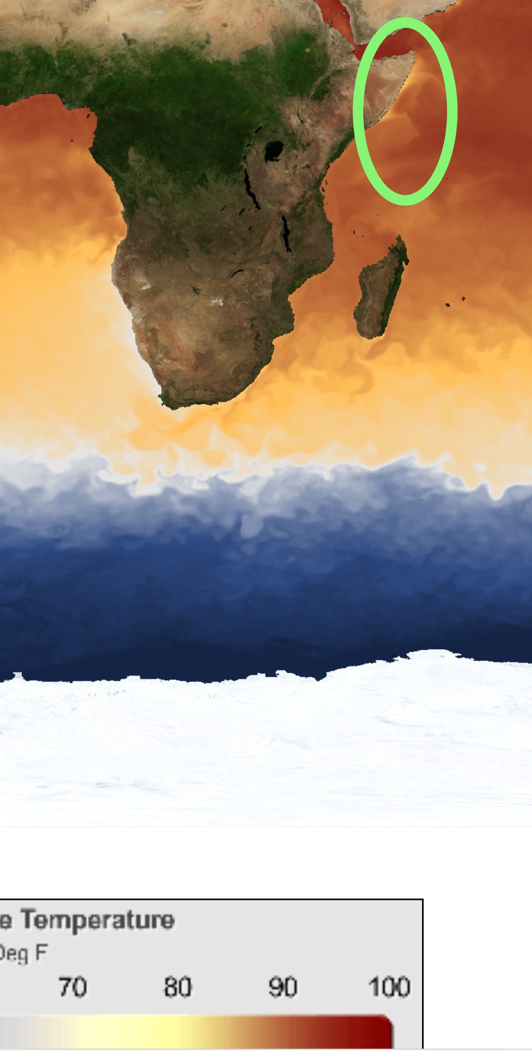
Now, re-forming is happening, and the Somali winds are cooling the Sea around ( 20°) as of now.
Upper SW winds will organise, and dump Monsoon rains over Kerala around 27th May.
Expecting a little slow progress Northwards after the Kerala advance. ( For a week).
Point wise for next 4 days... From Monday 23-26th
*Mumbai A mild drizzle on Saturday in few areas ..Does not mean Monsoon. Coming week will be Hot/humid around 34- 35c...Actually feeling 38c..maybe light drizzle in some parts on Wed, Thursday.
For Mumbai, these are Pre Monsoon rains..Proper Monsoon still 15 days away.
* Pune will be getting cloudy after noon...around 35c, but the UV-Index climbs up to 10,
*Konkan light to moderate passing showers this week.
* Vidharbh will see heat around 40- 43c
* Marathwada will be hot and dry. No rushing into sowing still.* मराठवाडा उष्ण आणि कोरडा राहील. पेरणीसाठी अद्याप घाई नाही.मान्सूनचे आगमन अजून १५ दिवस..जूनच्या पहिल्या आठवड्यात थोडा पाऊस
North India forecast: Temporary relief from the summer heat!! A moderate intensity Western Disturbance is expected to impact North India from tomorrow 23rd May. (Induced cyclonic circulation over Punjab and moisture from Arabian Sea and Bay of Bengal) to cause moderate to strong dust storms and Thundershowers (with chance of some hail) across Punjab, Haryana, North Rajasthan, Uttar Pradesh and north Madhya Pradesh regions on 23-24th May. Hill Sataes could witness moderate rain/thunderstorms with heavy in some parts, while upper reaches could see snow.
Delhi NCR: Thunder Squalls expected on 23rd/24th..with a slight fall in day temperature to 37/38c. Later, Thunderstorm activity to expand Eastward towards Bihar, Jharkhand, West Bengal, Odisha, east Madhya Pradesh and Chhattisgarh by 24th. Strong kalbaisakhis likely along northern east coast states.
Compilation by Shreyas & Rajesh.
.
Weekend Outlook: 20th/21st/22nd May
Mumbai: Partly cloudy and Humid. Sweat and High UV levels at 9..So take care in extreme sun. Days at 34c, will actually feel as hot as 38c.
Mumbai Lakes/Water Position: 15 May 2022... 22.99% Storage of Total Capacity.

Combined live storage across all lakes compared to 18.87% same time last year.
Pune: Getting cloudy by afternoon, bringing (only) hopes of rain. Days around 37/38c.High UV levels at 9, so take care in extreme sun.
As per the image posted yesterday evening under the snippets section, we saw some UAC induced thundershowers in Maharashtra! Here are some figures ending at 8:30am on 20/05/2022(in mm):
Sangli district:
1.Umadi:73
2.Sangli:61
3.Kirloskarwadi:57
4.Shigaon:50
5.Siddhewadi:45
Kolhapur district:
1.Kagal:50
2.Kolhapur:46
3.Tandulwadi:40
4.Nitawade:39
5.Gaganbawda:35
6.Mandukali:33
7.Dajipur:27
Satara district:
1.Urmodi:45
2.Sandavali:35
3.Nagthane:32
4.Apshinge:28
5.Shirdhon:25
6.Nawaja:19
Pune district:
1.Daund:27
2.Saswad & Velhe:16
3.Gunjavane:12
4.Sansar:9
5.LoniKalbhor:6
6.Katraj:5
Ahmednagar district:
1.Shrigonda:38
2.Kolgaon:6
Solapur district:
1.Solapur:36
2.Diksal:6
Data Credits: RTSFROS & IMD
Complied By: Vagarian Abhishek Apte
19th May
As on 19th, Monsoon not been established in Kerala, and therefore there is no official declaration of the Monsoon ( By IMD or Vagaries)....Explained below, it will be another 4/5 days before the Monsoon sets in over Kerala in strength.
A brief note on Southwest Monsoon - When Onset happens over Kerala, an offshore trough forms off the coast. Cyclonic circulations embedded in the UAC are common features, which help in northward advance of the Monsoon.
.png)
At present, at 850 levels, the west/northwest wind convergence is seen near Kerala due to the UAC located near Kerala/TN border. There is no offshore trough.


Tropical easterly jet at 200 hpa hasn't set in either. Additionally, the westerlies are not seen extending well into Tamil Nadu due to the UAC.

With heavy falls over Kerala, the notion of Monsoon rains seems practical, but not as a set system...Such pseudo onset like conditions have happened in the past, and mentioned in Vagaries a few times earlier. The rain with low clouds feels like Monsoon. But technically, considering the various above factors, proper atmospheric conditions of the Southwest Monsoon have not been established..
Maharashtra: Pre-Monsoon thunderstorm outlook for May 19-20.
🌧Rain/thundershowers likely in south Madhya Maharashtra districts of Kolhapur, Sangli, Solapur and Satara during next 2 days.
Parts of Pune and Ahmednagar districts can get patchy rain/thundershowers.
Southern districts of Marathwada region such as Latur, Beed and Nanded can expect some thundershowers in parts.
With the UAC expected to move north over land, parts of north Karnataka to also receive moderate to heavy thundershowers.
महाराष्ट्र: 19-20 मे साठी मान्सूनपूर्व वादळाचा अंदाज.

पुढील 2 दिवसांत दक्षिण मध्य महाराष्ट्रातील कोल्हापूर, सांगली, सोलापूर आणि सातारा जिल्ह्यांमध्ये मेघगर्जनेसह पाऊस पडण्याची शक्यता आहे.
पुणे आणि अहमदनगर जिल्ह्यांतील काही भागांत ढगांच्या गडगडाटासह पाऊस पडू शकतो.
मराठवाड्यातील दक्षिणेकडील जिल्हे जसे की लातूर, बीड आणि नांदेडमध्ये काही भागात मेघगर्जनेसह पावसाची शक्यता आहे.17th May Post:
.png)
Outlook till Thursday 20th May
Associated with the Upper-air circulation (UAC) over Kerala, moderate to heavy pre-monsoon rain/thunderstorms is likely over Kerala, Lakshadweep islands as well as coastal and Ghats of Karnataka.
Bangalore and Mysore regions can also get moderate thundershowers with some localized heavy rain.
Western parts of Tamil Nadu to also witness some thundershowers during this time.
Goa may see light rain in some parts towards late evening or night.
Mumbai: *This Week (17th-22nd): Hot/Sultry with high humidity ..The day temperatures will be around 34c, but the feel will be of 38c.
*Nights at 27/28c will be warm and stuffy.
*Pre monsoon rain in some areas may be experienced from next week (24th onwards).
Pune: *This Week (17th -22nd): Hot and sunny with day around 39c, and feels like 40c.
*Next week (23rd ..), the day s are expected to get better with the temperatures falling 3/4c to around 35c.
*Pre monsoon patchy rains expected next week (24th Onwards.)
16th May ...2022...Monsoon On Schedule in Andamans
.gif)
From Thai Met Dept :
South West Monsoon Advancing into Andamans and Maldives..ThailandNo. 5 Time Issued May 16, 2022the moderate southwest monsoon prevails across the Andaman Sea, Thailand and the Gulf.
From Sri Lanka Met Dept:
WEATHER FORECAST FOR 16 May 2022
Issued at 05.30 a.m. on 16 May 2022
South-west monsoon condition is gradually establishing over the island.
Heavy showers about 100 mm can occur at some places in Western and Sabaragamuwa provinces and in Kandy, Nuwara-Eliya, Galle and Matara districts.
Current Rains in Kerala due to UAC inland and strong Winds fro W/NW...

After a lull in Rains,
We will notice the 200 hpa jets getting organised for proper Monsoon advance into Kerala...South West Monsoon will establish in South Kerala around 27th-30 th May...


Likely developments for the advance of Southwest Monsoon 2022
Apart from the rainfall which can be influenced by many factors such as pull effect winds due to a cyclone, we look at some other wind patterns of the Monsoon which is a characteristic of the Monsoonal regime.
Following are some salient features of wind patterns of the Monsoon:
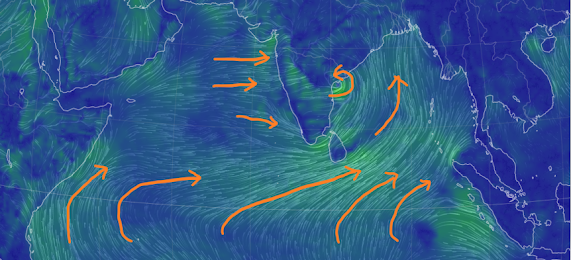
1) Westerlies at lower tropospheric levels (till ~600 hPa)
2) Easterlies in the upper atmospheric levels (~200 hPa)
3) Cross equatorial winds should turn to form the Somali Jet for the Monsoon to establish over the southern Arabian Sea.
After the likely onset over south Andaman and Nicobar islands, we expect the easterlies at 150-200 hPa to further extend till Sri Lanka and Maldives region by around 18th May. Combined with stronger low level westerlies, this would signal Monsoon conditions establishing over these regions by 18th-20th May.
The Somali Jet would also develop by that time and conditions could become favourable for Kerala onset of the Arabian Sea branch by around 26th May.
Verified & approved by Rajesh
Monsoon Watch - 4
As Cyclone Asani weakens and dissipates, the focus shifts to our Southwest Monsoon!
Cyclone Asani in the Bay of Bengal has proved to be helpful for the monsoon westerlies in ways summarized below:
1) The High Pressure Area/anticyclone in the Bay of Bengal is no more. Cyclone Asani has opened the gates for strong westerlies/south-westerlies from the equatorial Indian Ocean to reach Andaman and Nicobar islands, so expecting the monsoon currents to get organized in the Bay branch soon (see the surface and 850 hPa winds below)
Surface Winds


Expecting the Southwest Monsoon to reach south Andaman and Nicobar islands around 15th May!
3) Westerlies from the Arabian Sea have strengthened due to the pull effect from cyclone Asani. So no heatwave for interior konkan. Rise in humidity and increasing cumulus clouds along the west coast. The high pressure region (anticyclone) in western Arabian Sea has also weakened, thus allowing stronger flow of westerlies over the west coast and Ghats.
With westerlies at surface and low levels are strengthening, passing showers (pre-monsoon) likely along south Karnataka and Kerala coasts in the coming days.
Good rains from pull-effect westerlies due to cyclone Asani were observed over Kerala and south coastal Karnataka as indicated in our earlier post below.
4) The Seasonal Low is expected to deepen real fast, and could measure 994 mb in a week.
5) The Somali jet in the Arabian Sea is however not yet developed (normal for this time) but winds at 850 hPa close to Somalia are showing signs of strengthening, and should organize more in the coming days.
6) ENSO: LaNina to persist.
Expect SWM in Kerala by 30th May.
Asani Effect:
1. Bengaluru on 10th...cool day

2. More rain in Kerala... Less in AP./Odisha 😳( As on 11th Morning)
Chief amount of rainfall (in cm):
Kerala-Mahe: Kottoyam: Poonjar-15, Kanjirapalli-9; Kozha-7;
Idukki: Thodapuzha-11, Idukki-10; Ernakulam: Perumbur-Neryamanglam-9, Piravam &
Muvittupizha-8 each, Palluruthy-7; Kozhikode: Kozhikode, Vadakkara & Quilandi-8 each; Thrissur:
Chelakudi-8, Chimoni-7; Rayalaseema: YSR: Duvvur, Chepad & Cuddapah-11 each;
Coastal Andhra Pradesh: Vishakhapattnam: Narsipattnam-7;
Nellore: Kavali-7, Parkasam: Kandukur-7; Guntur: Bapatla-7, Viziyanagram: Mentada,
Pusapatrega & Gantyada-7 each;
Odisha: Keonjargarh: Anandpur & Ghasipura-7 each
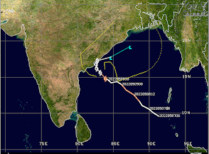
Severe Cyclone Asani Update - 10th May morning
Asani Re-Considering about Re- Curving ? STR resistance may be the hindrance... .
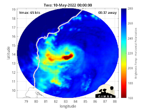
Slight overnight intensification of cyclone Asani observed. Max winds around 120 kmph.
Weak eyewall development seen in ring score analysis!

Monday Night Scenario:
Asani latest Severe Cyclonic Storm

UW - CIMSS
ADVANCED DVORAK TECHNIQUE
ADT-Version 9.0
Tropical Cyclone Intensity Algorithm
----- Current Analysis -----
Date : 09 MAY 2022 Time : 151500 UTC
Lat : 14:24:54 N Lon : 84:28:57 E
CI# /Pressure/ Vmax
3.5 / 987mb / 55kts
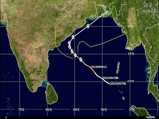
Center Temp : -82.0C Cloud Region Temp : -76.4CEstimated winds 100-110 kmphWith cooler SST & Dry inflows, likely to weaken as it re-curves NE on 10th Night..Will turn direction on Tuesday 10th Night,after grazing North A. P. Coast. Monday 9th May 2022 Morning update for Cyclone Asani over the Bay of Bengal

Severe cyclone Asani hasn't strengthened much. Favorable SSTs but battling moderate-high wind shear.
Asani may weaken slightly as explained and approach close to north AP/south Odisha coastline in another 36-48 hours before turning towards northeast.

Raigad District Talukawise Rainfall (mm) – 03 July 2026 (Highest to Lowest) Rainfall (mm) Pen 150 Shrivardhan 145 Tala 137 Uran 125 Mhasala ...


.png)
.png)
.png)
.png)
.png)


.png)


