Thursday, May 30, 2013

Vagaries has initiated a contest to predict the expected  rainfall  for June 2013..see  Monsoon June Contest Page,,,All are requested to Participate and make the contest interesting..Certificates of Summer Contest Winners on Monsoon Contest Page


Light rains from South Mumbai ...Dombivai and Panvel ...See Pics on Mumbai Page
1,2 mms at Colaba

Mumbai Water Supplying Lakes Position as on end of May..and Mumbai forecast for next few days on Mumbai Page..posted on Friday Night

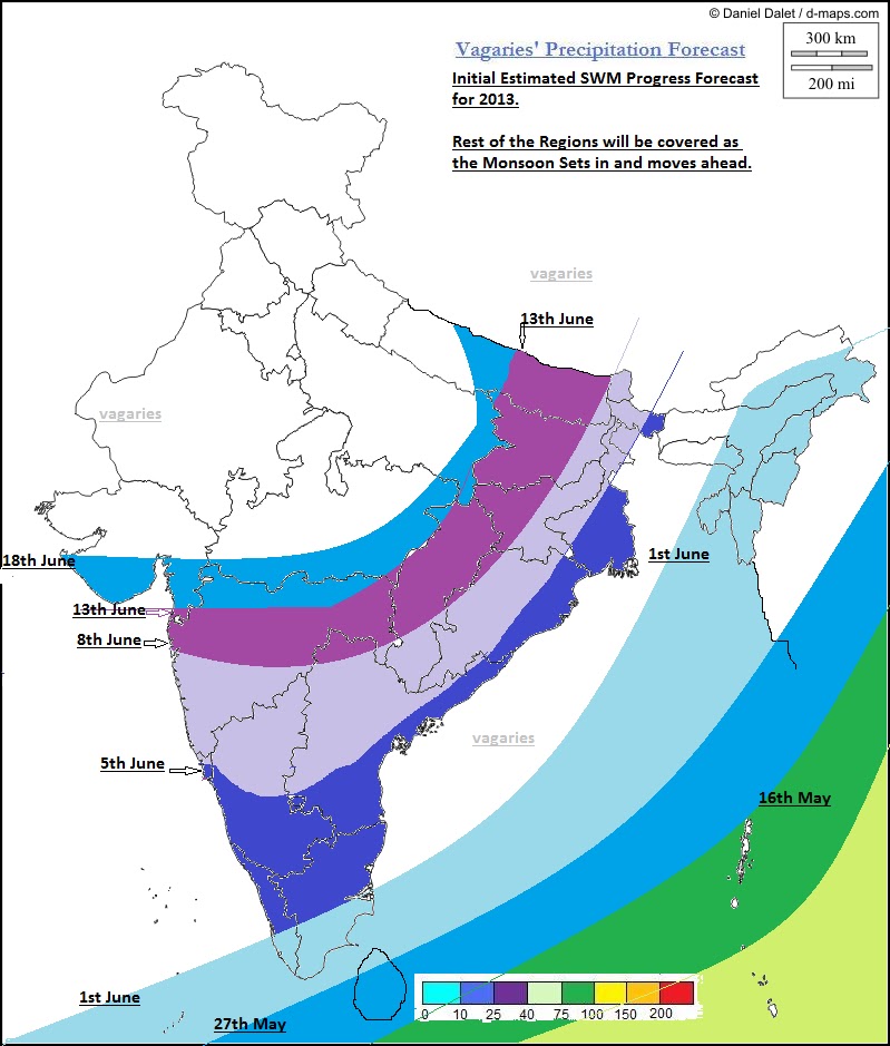
SWM Advances into Kerala and Far Eastern States.....posted Saturday 2 pm IST..see Monsoon Advance Position Chart Page

Posted on Thursday, 30th May:  SWM advancing in to Maldives and Comorin Regions.

BB-2 crossed land at the W. Bengal  coast on Wednesday at depression strength, and on Thursday evening, was at  a well marked low strength near Midnapore.
BB-2 will now move NW along the trough. Trough is situated from SE Uttar Pradesh running  SE  into the Bay thru BB-2.
The other system, AS-1 , has fizzled out over Oman, and no longer shows any pressure isobars.

Weekend day temperatures to rise in Sindh region of Pakistan. Days may touch 48/49c in Dadu, Larkana and Nawabshah. Sukkar and Hyderabad could reach 45c.
Karachi wil be around 36c.
Fairly heavy rains for Kathmandu on Friday and Saturday.

Outlook: Friday 31st, Saturday 1st June and Sunday 2nd June:
City forecast below….


City forecast for Friday, 31st, Saturday, 1st June and Sunday 2nd June:

Mumbai:  Days will be partly cloudy. Light rain shower possible in some parts of city. Friday and Saturday, sky will be hazy..Rain Amount : 2-4 mms.
 Cumulus clouds and possible thunder heads in the eastern horizon on Sunday evening.
Day temperatures around 34/35c and night will be warm and stuffy at 28/29c.

Outer Townships also partly cloudy. Thunder heads developing on Sunday evening…Light rains possible in some parts.

Pune will be partly cloudy. Cloudiness increasing on Saturday, with light rain showers in some parts. Thunder shower in some parts of city on Sunday evening.

Surat will be partly cloudy. Cloudiness increasing on Saturday.  Light rain likely in vicinity on Sunday.

Bangalore:  Thunder showers in different parts of Bangalore on Friday. Saturday, fairly heavy thunder shower. Sunday, decrease in rains with dim chances of rains.

Hyderabad: Heavy  thunder showers on week end, specially Sunday.

Aurangabad  vagaries' forecast appears in Lokmat Times (Aurangabad Edition) on Mondays and Fridays.
Shall try to give specific city forecast if required..

Sunday, May 26, 2013

 Position as on Wednesday 1 pm:

BB-2 now a depression, with 996 hpa core pressure and at 21.1 N and 89.5E, 200 kms SE of Kolkata.Winds at 25 knts and intense clouding from 13N Northwards and in the 82E to 94E region in the SW of centre.
Due to anti-cyclone in the NE, it will cross the Bangladesh coast after moving N/NE from current position, and will remain as depression on crossing.
High tides/waves and gusting winds of 35 knts on Bangladesh and adjoining W.Bengal coast.

AS-1 is situated at 18.5N and 57.5E, just off the South Oman coastline, about 100 kms away from shore, slight shifting westwards since last 12 hrs.


Position as on Tuesday Night: 

1. AS-1 is now crossing land at 18.7N and is at 58E...as a Low. Muscat will be cloudy with light rains on Wednesday 29th. Drop in day temperatures in Muscat.

Meanwhile, the West coast off shore trough weakly prevails near S.Konkan and Southwards till Kerala. On Tuesday, South Konkan, Goa and coastal Karnataka recieved thunder showers in varying amounts.
AS-1 crossing will clear the way for the "half formed" west coast trough to extend up into North Konkan on Wednesday. 

Mumbai and outer townships should see thunder heads forming on Wednesday 29th and Thursday 30th, with possibility of showers in outer townships in the evening.
On Wednesday and Thursday, clouding drifting in to Mumbai could bring some rain in some parts of Mumbai.

As mentioned, the off shore trough is weak, and will fizzle out from Thursday 30th. As the LWD regains its "lost" position back into the Interiors of the Peninsula, from Thursday/Friday we see thunder showers, vigorously coming in to the interior Mah and Karnataka regions. Madhya Mah and Marathwada regions get thunder showers on Thursday 30th/Friday 31st, while Vidarbha remains dry and hot.

2. BB-2 is stationary at 20.3N and 89.6E. Core pressure estimated at 998 mb and winds at 25 knts..already a well marked low, as mentioned yesterday, deepening further and could cross as a depression.Major clouding in West and SW quadrant while crossing. Intermittent rains for Kolkata on Wednesday and Thursday.

As BB-2 crosses, the LWD goes inland into the peninsula region, and the rainfall shifts to the interiors.
Chennai could get some relief from the sea breeze as the Easterlies would get stronger from Friday 31st.

3. Northern India, NWI and Pakistan remain dry next 3 days. But we see a rise of 2/3c in the Northern plains and NWI from Friday onwards.
Rise in day temperatures in Balochistan and Sindh from Thursday, possibly reaching 49/50c again.

Shall put up a separate forecast for Friday/Saturday and Sunday by Thursday evening.
See Monsoon Advance Page for regular SWM advance update

x---------------------------------x-----------------------------------------x-------------------------------------x-------x
Posted on  Tuesday Morning: 

Arabian Sea UAC descends to sea level and as "AS-1" is located at 18N and 60E. At 1006 mb, expected to move into Oman .
BB-2 lies stationary at 21N and 89E, at estimated pressure of 1000 mb. Just South of India/Bangladesh border, expected to move NE.

The East coast off shore trough has drifted Eastwards a bit under the effect of BB-2. Thunder shower likely for Chennai or vicinity on Tuesday.

The West coast off shore trough could get re organised by Wednesday as the AS-1 crosses land.

Posted 28 May 00:30 am IST

What Vagaries had forecasted till Monday 27th ( In last post on 24th May):
1. "An trough off the west coast of India may form and result in thunders shower in and around Mumbai, S.Konkan, Goa and coastal Karnataka Sunday26th/Monday 27th.
Pre- Monsoon showers expected around Mumbai vicinity on 26th may/27th May. Pre-Monsoon thunder showers increase after 3rd/4th June."

2. M-3 coming, may see NW Sub-Continent day temperatures will further fall by around 2c next 2 days. However, the hot days in AP and coastal TN will see lower day temperatures from Monday, to the extent of 2/3c"


And to what extent it happened :
1. A weak off shore trough formed off the coast from South Konkan downwards till Kerala. Resulting in thundershowers in South Konkan, Goa, and coastal Karnataka and Kerala. Kearala and coastal Karnataka are receiving Thunder showers from Saturday 24th, while South Konkan and Goa received on Sunday 25th and Monday 27th, specially heavier on Monday27th.

The UAC in Western Arabian Sea could be the spoil sport for North Konkan. Mid Sea winds from 15N got diverted and blew North wards from that line and re-curved clockwise into the UAC around the Oman coast.
I expect the UAC to descend and form a low, and  and cross into Oman. Things will get back to routine from Wednesday, and winds all along the coast will become SW. 
This will extend the off shore trough along N.Konkan and bring pre monsoon showers there.


BB-2 in the Bay has formed South of Bangladesh, with strong clouding in the SW and S quadrant. Expected to deepen to 996 mb ( depression)  and cross the Bangladesh coast byTues/Wed 29th. By Wednesday 29th, M-3 will have pulled and elongated the seasonal low right upto UP. 
This will result in a LWD running from Eastern Nepal thru into Bihar, Bengal and the Bay.
Clouding will be extensive along the LWD.
Heavy rains are likely in Bihar, W.Bengal and Bangladesh on Tues/Wednesday and  Thursday.
Would expect 55-60 mms in Kolkata on Thursday.


Friday, May 24, 2013


Monsoon Watch - 6  2013...24th May 2013

SWM has further moved into  Maldives and Northern Andaman Sea.

Cross Equatorial Flow has picked up considerably in the Bay and Arabian Sea. Winds over 40 knts are seen gushing Northwards off the Somali Coast, and 40 knts winds, rushing towards NE,  are also seen in the Bay.
Winds off the Sri Lanka coast have picked up considerably.

Today's SST map is reproduced here to show the Sea temperature falling sufficiently along the Somali coast. It is presently around 20/21c.


 Now, this difference with the Central Arabian Sea plays a key role in cloud formations off the Western Coastline of India in the Central Arabian Seas. The SST along the Somali coast will rapidly fall to around 18/20c in the next 10 days.

But the current fall is sufficient to help form Monsoon clouds around the Maldives. Cloud formation near Sri Lanka is gathering, and in next 24 hrs, wind speed along the Sri Lanka coast is estimated at 40knts (in gusts). 
A slight fall is seen in the Bay water's SST.

The ITCZ is slowly moving up, but is still around the Equator regions, and in the 7N region in the Bay sector.

SWM should set in over Sri Lanka within next 48 hrs, that is by the 27th May. 

The Seasonal Low seems to have strengthened. We see today's pressure at 998 mb. Getting gradually ready enough to create a gradient  to pull up SW winds into the mainland. The day temperatures on the Sub-Continent Northern plains are on the higher side from this week with the average the day's highs are around 43/44c.
Across in Pakistan' Sindh region, the core area for the formation of the low, the highest has already crossed 50c. 
M-3 effect is expected bring about a slight fall in the day readings.

M-3 (weak) is seen moving into India. 
WDs should slow down now, as the jet streams at 200 hpa are re-grouping fast into position. 


The Jet Stream Westerlies are almost upto the 15N line, and the "High" formation is taking shape in Eastern India. Expected placement of this "High" should be inland towards MP for perfect position.

The Bay sector SWM has been stagnant, and not picking up as expected from a "setting in" Monsoon. 
As SW winds have picked up speed,a Low could form in the Northern Bay off the Bangladesh coast by the 27th. 
In the next 3/4 days, SWM, could advance further into the Bay. UTH map shows the "utmost" readiness for a low and further advance in Bay of SWM.

Better this happens before another WD reaches the region to spoil the "party".

Changes in 850 hpa winds (anomaly) show a reviewed MJO pattern. Neutral in our seas till 5th June, but strengthening from 5th to 16th June..and thereafter  going back to neutral as the wave moves Eastwards.

Conclusion: 
SWM advancing into Sri Lanka by 27th.May. 
Advance into Kerala and Southern TN around Vagaries'expected date, 1st/2nd June. But, further advance would need monitoring. Possibly into Coastal Karnataka/Goa and  TN regions by the 5th of June. South Konkan 6th/7th June, and Mumbai by 8th/9th June.
SWM advance in to NE states by 29th/30th May.
Keep Checking Monsoon Advance Position in vagaries.

(This Monsoon chase is my personal view, and my personal analysis and deciphering is done as per my assumptions. Should not be used for commercial purposes). 

An trough off the west coast of India may form and result in thunders shower in and around Mumbai, S.Konkan, Goa and coastal Karnataka Sunday 26th/Monday 27th.
Pre- Monsoon showers expected around Mumbai vicinity on 26th may/27th May. Pre-Monsoon thunder showers increase after 3rd/4th June.
See Mumbai Forecast on Mumbai Page.

M-3 coming, may see NW Sub-Continent day temperatures will further fall by around 2c next 2 days. However, the hot days in AP and coastal TN will see lower day temperatures from Monday, to the extent of 2/3c

Thursday, May 23, 2013

MW-6 under finalisation..will be published on Friday Night @ 11.30 pm IST

Response to queries:
 

No major changes to the Mumbai Forecast put up earlier on Mumbai Page.
In fact, for Mumbai, i would estimate around < 5 mms average rain on Saturday 25th (upto Sunday 8.30 am) and 5-7 mms average on Sunday 26th, up to Monday morning readings.
 

The Arabian Sea UAC will descend as a low will remain weak, and fizzle out after moving West.
Some rains in Southern Oman on Sunday/Monday.

Heat Wave in Pakistan and India:..23rd May 2013

Hottest places  on 23rd May :
Pakistan: Jacobabad  50.0c, ,  Nawabshah 49.5c, , Sibbi, Larkana 49.0°C, Sukkur,  48°C, Pad Idan  and Faisalabad  47.5c.

Minimums (Pakistan) : Sibi 31.7c,  

India: Ganganagar 48.6c,  Amritsar  48.0c (All time record), Rentachintala and Dholpur 47.5c,

Churu,  Hissar and Chandrapur  47.3 °C, Delhi AP (Palam)  47.2c,  Ayanagar 47.0c, Rentachintala (A.P.) 47.1 °C,  Ramgundam  46.8 °C,  Agra (U.P.) 46.6 °C,  Nagpur Sonegaon   46.6 °C,  Allahabad / Bamhrauli   46.5 °C,  Bikaner  46.5 °C,  Raipur  46.3 °C
Chennai  (NGM) 41.3c  ( MKBM) 41.8c.  
 Mumbai Clb  35.2c       SCZ   34.0c (Mumbai Temps are Maximum, not minimum J

Minimums: India: Indirapuram (NCR) 32.9c, Nagpur  32.2c,  Chandrapur  31.6c,  Delhi Sjung 31.4c,


Wednesday, May 22, 2013


Very  Hot  Day for the Sub –Continent on Wednesday, 22nd May 2013…

Hottest in the Sub_Continent  on Wednesday:  
Pakistan:  Jacobabad 50.0c, Sibi and Larkhana  49.0c, Sukkur 48c, Nawabshah 47.5c,

India: Ganganagar and Chandrapur  48.2c, Amraoti 48.0c,  Nagpur AP  47.9c (Highest ever for Nagpur)*, Amritsar and Churu  47.2c, Raipur 46.6c, Delhi  Palam 46.3c,  Delhi Sjung   44.9c.

*Nagpur City old  Observatory , which is not functioning now, has a recorded temperature of 48.6c on 24th May 1954.

And the minimums…Gwalior  34.9c, Chandrapur 34.2c, Nagpur  33.7c, Akola 30.5c,
Multan and Sukkur 30c (Pakistan)


Monday, May 20, 2013

Mumbai  Special Outlook till Sunday, 26th May:;Posted on Mumbai Page on Tuesday 10.30 pm IST

Answer to several Queries from Mumbai: Sunday 26th rain forecast for Mumbai is NOT Monsoon advancing. They are pre-monsoon thundershowers due to a weak off shore trough. There could be a gap in showers before another round of pre-monsoon thundershowers revive around 3rd/4th June again.
 

Sadly, the death toll throughout the Moore Ok area has risen to 91 this morning. Unfortunately, this number is likely to rise...Our Thoughts and Prayers are with you Oklahoma
A significant severe weather outbreak is possible across North and Central Texas later today, including the DFW Metroplex and Waco, Temple and Killeen areas...See International page for Detailed Warnings..from Echo Storm and US National Weather Service.


Outlook for 21st, 22nd and 23rd:
Highlights:

1.Tuesday 21st, heavy thunder showers continue in Bangalore. Rainfall reducing elsewhere  in S.I. Karnataka on Tuesday and Wednesday. Some scattered thunder showers in N.I. Karnataka.

2.Tuesday, 21st onwards, Rainfall reduces from Maharashtra, from Tuesday itself.  Thunder showers reduce and almost decrease in South Konkan, Southern Mah. On Tuesday, isolated Thunder heads will be seen in the Eastern Skies of Pune.
Wednesday, 22nd, concentration of thunder showers in Tamil Nadu regions of Salem, Dharmapuri and West of Chennai. Some heavy thunder showers expected west of Chennai.

3.Nor'wester thunder squalls also retreat from Southern and Central W.Bengal. They will seem to have now concentrated in Southern Bangladesh.

4.From Wednesday, rainfall on the increase in Western Nepal.

5.On Thursday 23rd, rainfall from the regions of interior Karnataka and TN will see a major reduction.

6. Severe heat Waves with temperature in the 46-48c range in Rajasthan, UP, Parts of MP and Vidarbha Region of Mah. 48/50c likely in Parts of Balochistan and Sindh on Tuesday/Wednesday.
Vidarbha region will see a reduction in day temperatures from Wednesday by about 2c.

7.Monsoon Advancing in Maldives Regions and North of Andaman Islands in NE Bay.

Sunday, May 19, 2013

May Weather of Mumbai Weather and Outlook for the Month..and Lake levels..on Mumbai Page

UAC in Arabian Sea (mentioned in article below), descends as expected , to sea level, and moved West. At 60.5E and 13N, it is at 1006 mb on Sunday...

A new Page on the Blog has been added: "Monsoon Advance Position"..it will be updated as the SWM pregressess, and can be used to see current Monsoon Status...

Post of 16th May (Thursday)
Heat Wave to Grip NW India ans Pakistan Regions: 

Hottest in Pakistan on Thursday, 16th May: Larkana 48c., Jacobabad 47c.

Hottest in India on Thursday: Barmer and Jaisalmer at  46.0c, Nagpur 45.6c Ramagundam 45.0c.

Weather for the weekend, 17th,18th and 19th May.

North India remains dry and hot.

We see the day temperatures rising in Balochistan  and Sindh in Pakistan thru Rajasthan , Punjab, Haryana and Delhi into India. 
Hot conditions likely in Gujarat, UP and Northern MP.

Day temperatures likely to reach 49/50c in Balochistan/Sindh regions of Pakistan.
Rajasthan, adjoining MP and Haryana will see 45/46c, with the odd 47c.

Depression BB-1, erstwhile Cyclone Mahasen will move away, and precipitate rains in Meghalaya and NE states as a depression .

The Line of Wind discontinuity, runs perfectly in the peninsula, from North Mah down South till Kerala.

Weekend will see moderate thundershowers in N.I.Karnataka.
S.I. Kanataka will get heavy thunder showers on all the forecasted days.
Particularly heavy rains are possible in the districts of Dakshin Karnataka, Hasan, Kodagu, Mandya, Tumkur and Bangalore.

Bangalore can expect heavy thunder showers and squall on the weekend.
On Sunday, a vortex may form in the trough, around S.I. Karnataka, hence I would expect heavy showers for Bangalore on Saturday, Sunday and Monday.

AN UAC is likely to form off the Kerala coast on Sunday, 19th. Could be located to the SW off the coast of Kerala.
Would sink to a sea level low (1006mb) on Monday.
As of today (Thursday), expected movement of Low is Westerly. Strengthening may be slow due to resisting High pressure to the North.

NE states would get heavy showers. Eastern Nepal will get weekend thunder showers  Kathmandu which got showers today, will heat by a couple of degrees on the weekend to reach 31/32c. But evening thunder showers are possible.

City Forecasts for the Weekend:

Mumbai (Scruz): Partly cloudy. Hot humid days and stuffy nights, Days will be around 33/34c and nights rising to 25/26c.
Outer townships getting hotter again, after a respite, days expected to touch 37/38c, but more humidity.

Pune: Partly cloudy, but very hot in the sun. Days expected to rise to 39/40c.

New Delhi: Very hot and dry. Surrounding hot dry winds will bring in heat on weekend, with the day touching  44c. Nights warming up to 28/29c.

Nagpur: Sunny day, partly cloudy in the evening. Days will be 46/47c, and nights will be an unbearable 30/31c.

Surat: Sunny and warm, humid at 34 -27/28c.


BangaloreThunder showers, very heavy in some parts. Squall and thunder showers heavy on Sunday.

Kolkata: Partly cloudy days, and stuffy at night, as minimum temperature will be around 26/27c. Days will remain in the 36/37c range this weekend.

SWM advances into Andamans Today:


Friday, May 17, 2013


Monsoon Watch 5-Arrival Dates.

As always explained, the MW parameters are to represent the progress of the developments in the Monsoon build up. On "as-is-where-is-today" basis, Vagaries calculates and forecasts the arrival date of the Monsoon. Again, these parameters are not referred in this MW for the quantum of rainfall. 

The, normally expected and much talked about (in our MW series) low from the Bay came and became a Cyclone, adding much vigour and momentum to the SWM.

Current Status:
Bay factor: In the Bay sector, the SWM has moved into the South Andaman Seas on the 14th of May, and into the rest of Andaman on 16th. This pull was aided by the Cyclonic storm "Mahasen". In the Bay sector,the attached UTH map shows the advancing of a SWM current in the Southern regions


The cross-equatorial wind is re-building and reorganising again across the East Indian Ocean. SW winds are clocking 30 knts South and SW of Sri Lanka. 

Onward Monsoon progress Northwards towards the NE States will have to be monitored, but the approximate dates are shown in the map.

The latest winds in the Bay continues to show strong winds rushing Northwards along the East coast of India, and re-curving into a Westerly flow of winds at the South Myanmar coast.

A lone pre-Monsoon low (B-1) had appeared in the region (early May) this year. 
Indicator : +ve

The cross equatorial flow: This flow off the African Coast, in the Western Indian Ocean, this was a bit "disrupted" previously, but has now re-formed itself fast, and is strong off the African Coast South of the Equator. 
The Somali Current, is getting defined, and blowing strong, with winds at >35 knts off the coast! We will wait for the Somali coastal SST to drop further.


 In the map, observe the difference in SST along Somali Coast and Central Arabian Sea.The SST off theSomali coast is 23/24c.
The previously weak factor, the equatorial cross flow South of the Arabian Sea, is steady. 

With a Low forming in the SE Arabian Sea by the 19th of May, the winds will gather speed, and enhance clouding in the mid- Arabian Sea.

The Mascarene highs are established at 1030 mb, are are now "pushing" the South-Easterlies from below the Equator.  

However, I feel, a real good booster is required for the Arabian Sea branch of the Monsoon. 
Indicator: Improved since MW4

Seasonal Low: With the heat factor still lacking absolute "full strength", in the Northern regions, the Seasonal Low core in the Thar Desert is now somewhat "unsteady", with a core pressure at 1000 mb, and requires to spread more westwards, rather than east. This (pulling Eastwards) is happening due to recent  WDs (M-1).

The heat waves are just about to revive. However, the minimums still showing vast regions in the below normal range. By this time each year, vagaries normally charts the "above 30c" minimums. But this year as yet, forget 30s, we are still barely reaching 26s in the night, with the odd one out in the NW plummeting to below 20c recently.
And the days ? Good, and 47/48 is just about getting its foothold!

To refresh, reproducing a clipping from Vagaries of 10th May 2011: "Readings of 10th May:
Hottest in Asia: Larkana (Pakistan) 48c, Nawabshah and Jacobabad  47c.
Hottest in India: 45.2c at Khajuraho, Agra  44.7c,  44.5c at Brahmapuri. 
Lows above 30c in India: Khajuraho 31c, Gwalior  30.7c, Gondia  30.4c, Kota  30.3c, Satna  30.2c. No lows above 30c noticed in Pakistan".

The Heat wave expected now, in the Western Sector of the Sub-Continent in next few days, will deepen the seasonal low and its core.

A North-South trough indicates the line of wind dis-continuity is unfavourably tilted towards the east in the Peninsula region. Normally, a perpendicular N-S trough is an ideal pre monsoon formation, and is a fore-runner for the seasonal low to stretch its presence over central India. 

As mentioned in my MW prevoiusly, the creation of a good gradiant between Kerala pressure and Rajasthan/Sindh pressure is an absolute requirment. And that is a must for creating a pull Northwards for the Monsoon. Overall position in this parameter is improved slightly since MW 4. 
Indicator: Neutral

The ITCZ now runs along the Equator from the African coast to Andaman  Island. Normal,for it to touch the equator around the 10th. (For more read previous MW).
Indicator: +ve

The 200 hpa jet stream: Normally, they should be Easterlies right upto 20N by May end. This would facilitate the Northward movement of the Monsoon Current. Today, the Easterly jet stream is developing  upto 10N. These 200 hpa jets winds normally need to come upto 10N by 15th.of May, so would consider this parameter as doing well. 
Then move upto 10-15N before 20th.May, to be in time for the Maldives Monsoon arrival.

The 200 hpa jet streams did get a bit dis- organised in the Bay recently. 
Indicator: Normal.

Arrival Time Conclusion: 
Vagaries  advance map for easy reading.


SWM has feebly moved into the Andaman Region. 

SWM will start covering the complete Bay Islands to reach the NE states by the 1st of June. 

SWM could be expected over the Maldives by the 20th of May.(Normal date 20th). Over Sri Lanka around the 27th of May.

I would estimate the SWM to advance into Kerala around June 1st/2nd could be the date for Kerala, but remain weakish till the middle of June in coastal Karnataka and Kerala.

Initially, as a result of a weak MJO wave, the SWM would be weak in Kerala in June. The further current into Kerala would be "reluctant" to move ahead in a weak MJO, as International forecasters predict the MJO phase in our seas to become weak up to the 10th of June. 

Nevertheless, the SWM could progressively advance into Goa/coastal Karnataka from 5th June, and Mumbai by the 9th/10th. of June. . 
SWM could delay advance into interior Karnataka and interior Maharashtra by a week from the 10th.

Around 18th of June, I would include entire Mah and South Gujarat as covered by the SWM. I would put the SWM in a weakish phase till the 15th.  

Mumbai can get pre-monsoon thunder showers from 28th/29th May.
Pre-Monsoon thunder showers can be expected in the outer townships from the 28th/29th May.

(This Monsoon chase is my personal view, and my personal analysis and deciphering is done as per my assumptions. Should not be used for commercial purposes). 

Next MW-6 will be published on 24th May evening.

Thursday, May 16, 2013

Post of 16th May (Thursday)
Heat Wave to Grip NW India ans Pakistan Regions: 

Hottest in Pakistan on Thursday, 16th May: Larkana 48c., Jacobabad 47c.

Hottest in India on Thursday: Barmer and Jaisalmer at  46.0c, Nagpur 45.6c Ramagundam 45.0c.

Weather for the weekend, 17th,18th and 19th May.

North India remains dry and hot.

We see the day temperatures rising in Balochistan  and Sindh in Pakistan thru Rajasthan , Punjab, Haryana and Delhi into India. 
Hot conditions likely in Gujarat, UP and Northern MP.

Day temperatures likely to reach 49/50c in Balochistan/Sindh regions of Pakistan.
Rajasthan, adjoining MP and Haryana will see 45/46c, with the odd 47c.

Depression BB-1, erstwhile Cyclone Mahasen will move away, and precipitate rains in Meghalaya and NE states as a depression .

The Line of Wind discontinuity, runs perfectly in the peninsula, from North Mah down South till Kerala.

Weekend will see moderate thundershowers in N.I.Karnataka.
S.I. Kanataka will get heavy thunder showers on all the forecasted days.
Particularly heavy rains are possible in the districts of Dakshin Karnataka, Hasan, Kodagu, Mandya, Tumkur and Bangalore.

Bangalore can expect heavy thunder showers and squall on the weekend.
On Sunday, a vortex may form in the trough, around S.I. Karnataka, hence I would expect heavy showers for Bangalore on Saturday, Sunday and Monday.

AN UAC is likely to form off the Kerala coast on Sunday, 19th. Could be located to the SW off the coast of Kerala.
Would sink to a sea level low (1006mb) on Monday.
As of today (Thursday), expected movement of Low is Westerly. Strengthening may be slow due to resisting High pressure to the North.

NE states would get heavy showers. Eastern Nepal will get weekend thunder showers  Kathmandu which got showers today, will heat by a couple of degrees on the weekend to reach 31/32c. But evening thunder showers are possible.

City Forecasts for the Weekend:

Mumbai (Scruz): Partly cloudy. Hot humid days and stuffy nights, Days will be around 33/34c and nights rising to 25/26c.
Outer townships getting hotter again, after a respite, days expected to touch 37/38c, but more humidity.

Pune: Partly cloudy, but very hot in the sun. Days expected to rise to 39/40c.

New Delhi: Very hot and dry. Surrounding hot dry winds will bring in heat on weekend, with the day touching  44c. Nights warming up to 28/29c.

Nagpur: Sunny day, partly cloudy in the evening. Days will be 46/47c, and nights will be an unbearable 30/31c.

Surat: Sunny and warm, humid at 34 -27/28c.


BangaloreThunder showers, very heavy in some parts. Squall and thunder showers heavy on Sunday.

Kolkata: Partly cloudy days, and stuffy at night, as minimum temperature will be around 26/27c. Days will remain in the 36/37c range this weekend.

SWM advances into Andamans Today:


MW-5 Will be Published on Friday Night...

Cyclone Mahasen:
Cyclone Mahasen to make landfall by 4 pm IST on Thursday at 91E, Southern Delta region of Bangladesh

South West Monsoon Moving into Rest of Andamans on 16th May...posted on 16th May @ 2 pm IST


Cyclone Mahasen:  Tracked NE, and still shy of striking land. Around 290 Kms SE of Kolkata, at 21N and 90.4E, and at 986 mb, with core winds now gushing at 50-55 knts. Very heavy rainfall reported North of centre of system...expected rains in coastal Bangladesh and adjoining W Bengal shores around 7-9 cms or more.
May swerve NE and make landfall today (Thursday) along the Bangladesh Coast. Inundating low areas, with precipitation in excess of 9 cms. 

Radar image from BMD

Wednesday, May 15, 2013

London Weather Analysis for Jan-May 15th from Rohit... on International Page
Konkan Analysis Jan-May from rohit ...on Mumbai Page.
Cyclone Mahasen Update as on Wednesday 15th Noon and 3 days Track Estimate


South West Monsoon Advances into South Andamans...14th May 2013              

Saturday, May 11, 2013

Cyclone Mahasen Latest Status:             >>>>>>>>>>


Cyclone Mahasen (BB-1) Position as on 12.30 am (IST)13th May : Location 10.7N and 86.6 E. Core pressure 996 and winds at 45 Knts. 
Precipitation expected on Sunday along TN coast, South AP coast and interior AP, adjoining Mah.

MW-4 (Part-2) 2013...Seasonal Quantum Performance of SWM.

Very Briefly, explaining the Factors considered for Seasonal Forecast:
Situation assessed after the arrival  of the SWM..and the scenario mentioned below are after the Monsoon sets in.

To take and assess the SWM performance, we refer back to the MW-4 (Part-1). We have to take into consideration most of the 15 parameters (Gowariker Method) before making an assessment, and these have to be analysed one by one. The prominent among the 15 are , ENSO, Mar temperatures of North India and East Coast, Himalayan Snow cover till March and SOI to name a few.
Of-course, I am not going to take each and every one of the 15 here, but, derive at an estimate on these basis and on the new model developed. I hope readers of vagaries trust that I have tried my best to estimate as accurately as possible.

If we take into account, that the ENSO will be Neutral, but "leaning" towards a weakish El-Nino phase by, say, August, then:

a) Till July end, we can see normal rainfall and progress of the SWM in the Sub_continent regions. Normal conditions in the Pacific Oceans will send a few "pulses" to create "in situ" systems in the Bay, and the first 2 months will see around 3/4 noteworthy systems traversing the Sub continent. WDs will be few, hence, we can expect a few systems to track towards Central and Northern India, resultig in good rains in the plains of N.India and Central Pakistan regions..and fairly good above normal rains in Nepal.
During the Northern track of the system, the monsoon trough could be pulled far North into the Himalayas, and possibility of "short "break Monsoon in 3rd week of July or near around thar time period.
Break monsoon situations, and winds bringing in moisture from the Bay (diverted to the NW directions) will result in excessive rainfall this season in Nepal, more so the Eastern regions. NE states of India will get continuous feeding from the Bay. (Cherrapunji seems the likely candidate for the highest SWM rains).

b) In such a scenario, even the Easterly 200 hps jet streams would move further Northwards. Could bring  rainfall to Upper Pakistan regions. Hence, rainfall could be  normal in rest Northern Pakistan and Kashmir.

c) Due to systems reluctant to track southwards, we may see lesser rains in the Southern Peninsula regions. Even the support to the west coast (South of Mumbai)may be lesser than normal. 
Hence, rain shadow regions in TN and interior Karnataka may be slightly deficient. However, normal gradient along the West coast will show rainfall along West Coast of India.


Things, if and when they change (drastically) will be posted and Vagaries readers will be kept well informed, of any variation in the forecast.  

These are my personal views, and should be depended upon commercially or otherwise. They may differ from other models.

Forecasted East rough  Let's look into the 3rd week of March ( 17th - 21st). Mumbai : Hot weather likely for Mumbai region this week, ty...