Number of Districts with above normal rainfall : 504
Number of Districts with below normal rainfall : 209
District with highest above normal rainfall (3043%) : JAMNAGAR (GUJARAT)

Number of Districts with above normal rainfall : 504
Number of Districts with below normal rainfall : 209
District with highest above normal rainfall (3043%) : JAMNAGAR (GUJARAT)
Bengaluru city had the wettest May in recorded history by receiving a rainfall of 301.3 mm for the month thus year. The previous record of 287.1 mm was recorded in May 1957! The average rainfall for the month is 128.7 mm.
31st May..
Cloud buildup seen over the southern parts of Arabian Sea and Maldives region as the cross-equatorial winds entering the region and converging.

Early indications of a monsoon vortex formation in south Arabian sea is forming in a couple of days, 4th/5th June.
This will lead to the Monsoon advance into Kerala by 4th June.
This system, AS-1, can strengthen and form into a depression as it tracks NNW. Sea surface temperatures in South Arabian Sea of 30/31c presently are very conducive for the possibility of a cyclone forming ( early to commit now). The stronger system can track tentatively should be NNW toward Sindh coast.
As the AS-1 system tracks along the coast we may see Monsoon progress, into Coastal Karnataka.
As the System veers NW. , the Monsoon onset over Goa and Konkan may be delayed to 13th/14th June. However, things are still uncertain.
Mumbai: Pre Monsoon evening showers possible from 7th/8th June. However, proper Monsoon set around 14th/15th June, seeing todays scenario.
29th May....
IPL 2023 Finals:
Even though the rainstorms in Ahmedabad are unseasonal and this was a safe venue,
Vagaries feels Weather should be considered while planning tournaments...
World Cup is scheduled from 5th October this year...except NW India, chance of rain persists for almost all other states considering delayed SWM withdrawal since last few years
Thiruvananthapuram, Bangalore, Chennai are potential rainy venues and may host World Cup matches in October 🌝⛈️
We expect the monsoon winds to strengthen in the coming days. Southwest Monsoon onset is expected over Andaman-Nicobar islands around 29th-30th May. The Arabian Sea branch of Monsoon is likely to reach Kerala around 4th-6th June.
Monsoon may reach Mumbai between 12th-15th June. However, the further advance of the monsoon along west coast after reaching Kerala can be affected if a low pressure system forms in the Arabian Sea.
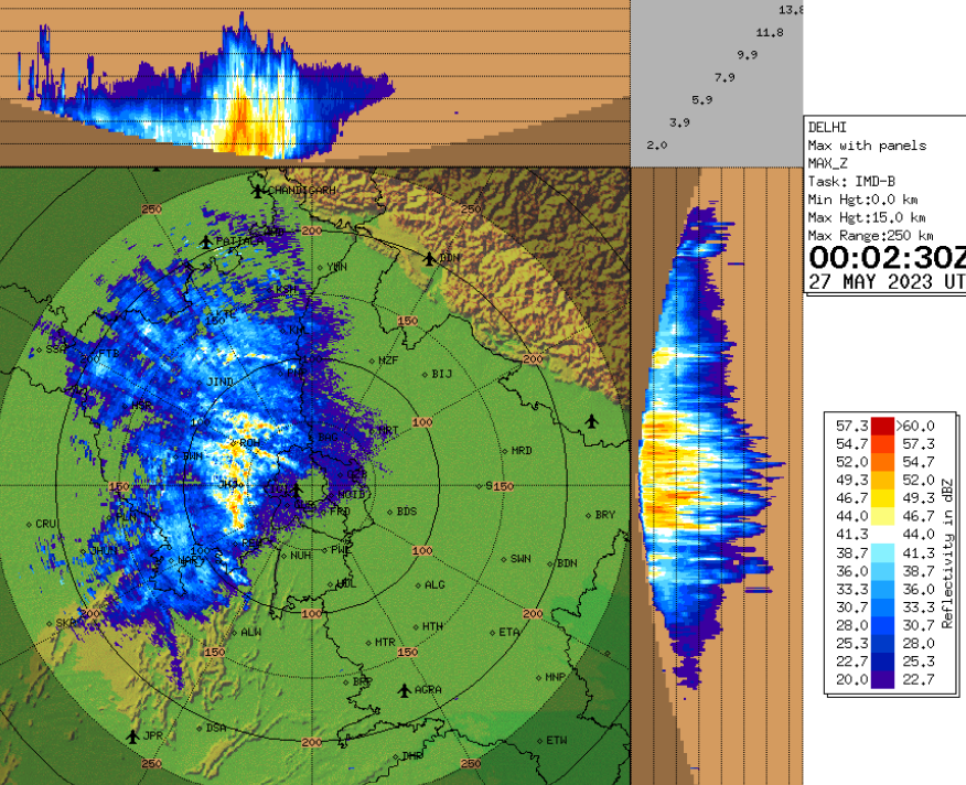
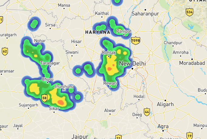
Meanwhile, North India seeing significantly below normal temperatures, with strong thunderstorms and hailstorms. The much hyped severe heat in Delhi and NW India did not occur, with temperatures mostly normal to below normal if averaged over last 2 months.
May 1st - 26th Day temperatures Anomaly 👇

Weather outlook from Wednesday 25th May to Sunday 29th May - WD impacts north, humid May weather for west coast
Westerly winds at lower levels to strengthen, so some drop in maximum temperatures is likely for konkan and Madhya Maharashtra.
Mumbai: Partly cloudy skies, increased clouds by night/early morning, typical humid May weather. Chance of passing light shower/drizzle in MMR region. Max/min around 33C/27C.
Eastern outer townships/Thane district will see max around 35-37C.
Konkan and Goa: Similar weather as Mumbai, very sultry days with chance of light passing showers.
Pune: Slight drop in max temperature is expected. Max to be around 37-38C, but min can be around 23C.
Marathwada: Most districts to see max around 39-40C.
Vidarbha: Hottest region of Maharashtra, with max around 42C.
Gujarat: Mainly dry weather. Slight windy for parts of Saurashtra and Kutch. Localized thundery development may occur over Saurashtra/Kutch. Max around 38-40C in most places.
Southwest Monsoon advance has been delayed this year. We expect the Bay branch to finally gain strength and advance over parts of Andaman-Nicobar region by 29th-30th May.
The Arabian Sea branch will also be delayed, as mentioned in Monsoon Watch outlooks. Kerala SWM onset can be between 3rd to 5th June.
More updates on SWM by the weekend...
The Mumbai lakes and dams level reported at 6 am on 19th May 2023 is 256518 ML (18%) of the total 1447363 ML.
Last year on 19th May 2022 was 315009 ML (22 %) of the total 1447363 ML.
That amounts to around 2 months Stock.
The water level information source is from Hydraulic Engineer’s Department of BrihanMumbai Mahanagarpalika.
Posted 18th May....Outlook for this Weekend 19th -21st May
Monsoon: Earlier this week, we had mentioned the arrival of the South West Monsoon over Andaman Islands around 20th.
We observe the Monsoon advancing over South Andamans (Port Blair) by 20th May.
Normal May weather..hot...hot and humid for Konkan.
Mumbai:
*Discomfort with day around 35°c
* Average humidity @ 65/70%
* Real feel temperature @39°c
* Warm and sweaty nights...not going below 27°c.
*Pre Monsoon thundershowers around 2nd week of June
Pune:
* Hot during day at 38/40°c
* Night not showing relief even at 23°c.
* Pre Monsoon Thundershowers around 2nd week of June.
Goa: Very hot and humid at 35°c..No relief at night as temperatures will not go below 28°c
Mahabaleshwar: Warm on the day at 32°c. Effect of a drop to 20°c will not be much of a relief for a hill station.
Marathwada & Vidharbh: Heat Wave With mercury reaching 42-43°c in Nagpur Akola, Sambhajinagar (Aurangabad), Nanded.
Monsoon expected after 12th June.
*मराठवाडा आणि विदर्भ: उष्णतेची लाट नागपूर अकोला, संभाजीनगर (औरंगाबाद), नांदेड येथे पारा ४२-४३ अंश से.Jalgaon to Amravati stretch in North Maharashtra can be the hottest with 43-44°C max
Gujarat:
Ahmedabad: Hot and very sunny with temperature around 42/43°c.Nights will be warm.
Surat/Bharuch: Almost similar at 38°c, with warm winds blowing in the day.
Monsoon Watch - 4..16th May 2023
This Monsoon Watch, we will be brief on the prevailing (changing) parameters of the Monsoon.
This year, I have observed a varying and fluctuating mode in the basic parameters. A little unusual (from my last 55 years of basic Monsoon development studies).
1. The Seasonal low is still steady at 1002/1004 hpa at the core. Should be getting lower gradually, but variations and cooler climes in end April/First half of May and persisting WDs kept this from occurring.
Showing the fluctuating trends, Will suddenly drop to 998 hpa around 23rd/24th May.
2. Heat wave...became effective only after the 18th of May.
3. Equatorial Cross Winds...Bay region disrupted by the Mocha Cyclone. See the SST and cooling caused by Mocha.

Arabian Sea Side is disturbed below the Equator by another Cyclone , now in Strength. (Fabien). Fabien expected to keep "ruling" till 22nd at least.
.png)
4. Jet Streams: The main force and "King" of season change, still dominating as Westerlies over the major region of the Sub Continent.

5. ENSO-neutral conditions are observed.
A transition from ENSO-neutral is expected in June/July, with a greater than 90% chance of El Niño persisting into October/November.
Understanding the the above criteria, we estimate:
Note:
Arrival Date*:
With a moderate summer (initially) in heartland India due to a series of WDs also preventing the "uppermost winds" from seasonal setting, disturbances by Mocha ( for the Bay branch) and now Fabien (for the Arabian Sea Branch), and a late season El Nino, we estimate
The arrival Date of the Indian South West Monsoon over the Bay Islands will be delayed by a week to 23rd May ( normal date 15th May).
However, the West Coast Branch of the Monsson, could be delayed by a few days, arriving at Kerala around 3rd/5th June against the normal date of 1st June.
Quantum*:
India being a big Country, the Spatial distribution of the rains will be varying a lot. Southern Peninsula may be slightly below Normal, West Coast Normal, Central India Normal, NW India slightly below normal and North normal.
The much talked about El-Nino factor is expected, but only in the later stages of the Monsoon, approximately in August/September. Hence, what we may see is initially good rains, but weaker precipitation in the second half of the season.
Overall, Vagaries' would estimate a near normal monsoon overall (97%-100%). The quantum and strength may lag in the second half of the season
IMD has estimated this years Monsoon quantum at around 96% +- 5% of the normal. That would mean in normal range.
Other competent Forecasters have indicated a weaker Monsoon.
===================================
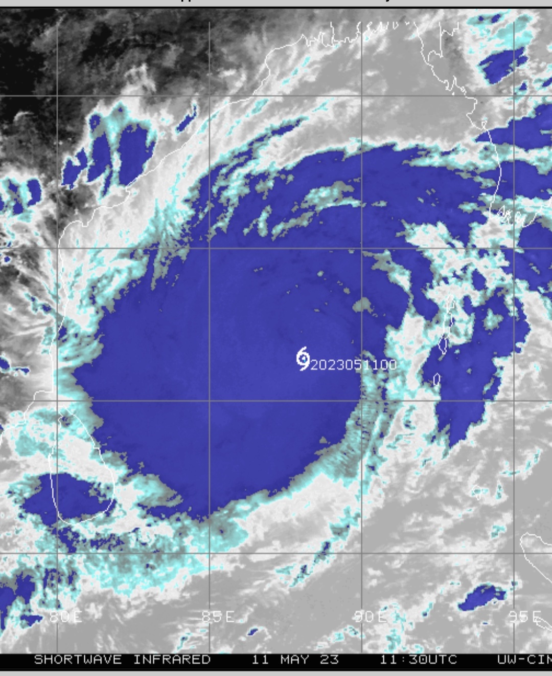
With a wind speed of 150 knots Cyclone Mocha equals the record of cyclone Fani of being the strongest north Indian Ocean cyclone since 1982 (including all months and both the Arabian Sea and the Bay of Bengal).
Cyclone Mocha is the strongest cyclone on earth till date among all the 16 cyclones this year.
(Note Data is as per JTWC. Analysed by Vagarian Vineet.)
As per JTWC Cyclone Mocha made landfall with winds close to 135 knots.
Strongest cyclones in the North Indian Ocean having maximum winds of 115 knots or higher (as per Joint Typhoon Warning Center records):
Mocha (BoB, May 2023) 150 knots
Fani (BoB, May 2019) 150 knots
Amphan (BoB, May 2020) 145 knots
Gonu (AS, June 2007) 145 knots
1999 Super cyclone (BoB, October 1999) 140 knots
Phailin (BoB, October 2013) 140 knots
Sidr (BoB, November 2007) 140 knots
1991 (BoB, April 1991) 140 knots
Kyarr (AS, October 2019) 135 knots
Giri (BoB, October 2010) 135 knots
Chapala (AS, October 2015) 130 knots
Phet (AS, June 2010) 125 knots
1994 (BoB, April 1994) 125 knots
1990 (BoB, May 1990) 125 knots
Tauktae (AS, May 2021) 120 knots
Mala (BoB, April 2006) 120 knots
1999 (BoB, October 1999) 120 knots
1982 (BoB, April 1982) 120 knots
Hudhud (BoB, October 2014) 115 knots
Nilofar (AS, November 2014) 115 knots
Nargis (BoB, April 2008) 115 knots
1997 (BoB, May 1997) 115 knots
1996 (BoB, November 1996) 115 knots
Note: The naming of cyclones in the North Indian Ocean started from 2004.
Compilation by Vagarian Shreyas & Vagarian Vineet

Cyclone Mocha - Impacts likely on northeastern states of India!

Cyclone Mocha is expected to make landfall near Myanmar/Bangladesh border region by the afternoon of Sunday 14th May and continue to travel northeast as it weakens.
Moderate to heavy rain is expected in Tripura, Nagaland, Mizoram and Manipur Sunday 14th evening and continuing overnight.
Winds can be stronger over Tripura and Mizoram, gusting upto 50 kmph along with 150-200 mm rainfall
Winds may be around 20-30 kmph for Nagaland and Manipur, along with 80-150 mm rain.
Imphal, after a near record hot day at 35.6°c a few days ago, will get a good relief.
Rainfall will be heavier for the higher elevations.
Eastern parts of Assam, Meghalaya and Arunachal Pradesh to receive moderate rain, with some heavy spells possible in eastern Assam and Arunachal Pradesh mountains, upto 80-120 mm.
Higher ranges of Himalayas in Arunachal Pradesh can receive moderate snowfall.
As per JTWC, Cyclone Mocha is now the 4th strongest cyclone (with wind speed 130 knots) in the Bay of Bengal in pre-monsoon season (April-June) since 1982.
Top 4 strongest cyclones:
1. Fani: 150 knots
2. Amphan: 145 knots
3. April 1991 cyclone: 140 knots
4. Mocha: 130 knots
Very rapid intensification of #CycloneMocha from category 1 (65 knots) to category 4 (115 knots) cyclone in last 24hrs.
In pre-monsoon season (April-June) in the Bay of Bengal since 2000 #CycloneMocha became the second most intense, rapidly intensifying cyclone, tied with April 2006 cyclone as per JTWC
Top 2 most intense rapid intensification
1. Cyclone Amphan (May 2020), which intensified by 65 knots in 24hrs
2. April 2006 and Mocha May 2023, which intensified by 50 knots in 24hrs
It is tied with 3rd most intense TC in Bay in May since 1982 as per JTWC with a maximum wind speed of 115 knots as per JTWC.
Top 3 intense TC in Bay in May
1. Amphan (145 kts)
2. May 1990 (125 kts)
3. May 1997 and Mocha (115 kts)
The maximum convection (red shades) continued to be centered in the western, southwestern quadrant of Cyclone Mocha.


Cyclone Mocha


Eye formation👆
Vineet's Page Updated with Cyclone progress details
On 11 May Pune Shivajinagar recorded 41C, which is the highest temperature recorded in Pune in May after 2019. Also, this is the third time this season that Pune Shivajinagar temperature crossed 40c mark.
10th May
As expected by our interpretations research based on previous analysis of weather during cyclone,
Vagaries explained that cyclone induced subsidence and sucking up moisture from land will lead to rapid rise in temperatures and same is happening
Yes anticyclone development too aiding temperature rise in maharashtra
With the formation of cyclone in bay, temperature started rising rapidly over Indian landmass. Alongwith 10 Staions in Maharashtra Pune hit 40.1c highest of the season. And more than 35 staions in India crossed the threshold of 40°c in India.


Temperatures to rise further.
Heatwave expected in large parts of india by 13 May. IN EXCESS OF 44/46 °C in Jalgaon, Vidharbh, Rajasthan, Gujarat Region and parts of West U.P.

Some people were not believing us when we told temperature to rise rapidly during cyclone formation time😁


Outlook for this week...Monday 8th May to Thursday 11th May...posted 7th Night.
The first low pressure of the year BB-1 is likely to form by 8th May west of Nicobar islands in the Bay of Bengal.
BB-1 will intensify into a depression around 9th, and then into a cyclone by 10th/11th May.
Heavy rain, strong winds and very rough sea conditions are expected for Andaman and Nicobar islands.
No potential threat to Indian mainland coast
Initial path of BB-1 will be north-northwest and then turn northeast towards Myanmar.
BB-1 will open the gates for cross equatorial South-Westerlies to reach parts of southern Bay and Nicobar islands region...need to monitor if this leads to SWM onset over the Andaman-Nicobar islands.
BB-1 will cause subsidence over most of Indian region and suck out the moisture from the subcontinent.
⚠️ Heat Alert for NW and Central India.
As forecasted in our earlier post, the typical hot and dry 'May' weather is likely for North, Northwest and central India in the coming days.
By 11th, places will exceed 43°C in Rajasthan, Vidarbha, and Gujarat Region, and possibly cross 45°C in Vidarbha and Northwest India.
Mumbai:
*Warm and humid weather. Chance of some light patchy rain till Tuesday 9th May.
* Max/min around 33-34C and 26-27C.
*Eastern townships, Navi Mumbai region and Thane district may get some localized thundershowers.
*Interior Konkan, Panvel, Karjat may see higher max of 37-38°C as the week progresses.
Pune:
*Chance of thundershowers till 9th/10th May.
*Weather to warm up significantly after that.
*Days may reach around 39°C towards the end of this week.
*Min to be around 22°C.
Gujarat: Mainly hot and dry weather, with many places seeing around or above 40°C max temperature.
Ahmedabad/Gandhinagar region may see 42-43°C max this week. Baroda and Bhuj will also see max around 41°C. Bharuch region can also see max close to 40°C.
Surat will see max of around 35-36°C initially, but rising to 37-38°C by the end of the week.
Posted 6th May 2023
(Please give credit if any information taken from here.)
First initially ( in March-April) there were alarms of ..Alerts..heatwave warnings..sizzling summer ☀️ to touch 50°...worst for India...due to "various causes"...hyped to the limit


And then..in end April-May beginning..complete turn around...all previous warnings gone..
Historical rains in Kutch and Saurashtra..


THIS IS ACTUAL NATURAL CLIMATE CHANGE...
It has happened before..nothing unusual..or climate change..
Vagaries' archive records of 1982..show it


9th May Night Post 👇 No Warnings... All Temperatures in +_ 1° of normal range. Mumbai : Hot and humid.. Making Real Feel of 39°.. Day: ...


.png)
.png)