Thursday, August 31, 2023

Monsoon this August...2023

Mumbai:

Mumbai had a dry August After a nearly record rainfall in July. By end of  July, Mumbai Santacruz had received 92% of the seasonal rainfall.

In August, Santacruz measured 177 mms of rain , 31% (normal 562), and Colaba 112 mms 24% ( normal 472 mms).

So, though SantaCruz normally gets 24% of the seasonal rain in the month of August,  this year received 13% of the seasonal total in August. .

Lakes:

The Mumbai lakes and dams level reported at 6 am on 30th August 2023 is 1308021 ML (90 %).

Last year on 30th August 2022 was 1404404 ML (97 %).

In the year 2021 on 30th August 2021 was 1276377 ML (88 %).

40 days of Monsoon still remain. 

Pune: Pune received only 42 mms in August,  25% of the normal August rainfall. 

Pune region dams and reservoirs are today at 69.72%.

All Maharashtra dams and reservoirs are at 64.37%

Maharashtra August Rainfall: Yellow = Deficit, Red = Large Deficit

Bangaluru: The driest August on records since observations began. 12.4 mms in 2023, lowest record 20.6mms in 1885 !

It will be listed as one of the 'driest' months since 1901. There will be a deficiency of about 36% of rainfall in August 2023.


August 1899 has been the driest August,  at -40.4%, since reliable records began in 1871

Compilation of recorded by Vag.Vineet👇

After 1900.. During the period 1901-2023: Top 10 driest August for India

1. 2023: 162.7 mm ( -36%)
2. 1913: 189.8 mm
3. 2005: 190.1 mm
4. 1920: 190.8 mm
5. 2009: 192.5 mm
6. 2021: 196.2 mm
7. 1993: 198.8 mm
8. 1979: 199.3 mIm
9. 1902, 1905: 202.6 mm
10. 2015: 204.2 mm

During the period 1901-2023: Top 10 wettest August for India
1. 1926: 348 mm
2. 1958: 328.7 mm
3. 1933, 1963: 328.2 mm
4. 2020: 327 mm
5. 1988: 325.1 mm
6. 1976: 319.5 mm
7. 1970: 319.3 mm
8. 1931: 318.9 mm
9. 1916: 318.8 mm
10. 1955: 317.2 mm

For the period 1901-2022, August rainfall in the country is decreasing at the rate of 0.7mm/decade.

This year, throughout the month, break monsoon conditions prevailed for nearly 24 days. 

It is the month of September that holds the key to making or breaking the year. Although this month has a modest average of 167.9mm rainfall, it is considered the most volatile to change fortunes.

September assumes  importance. If the month receives its normal rainfall or even a modest shortfall of about 10%, the season can avert the drought scare.

Any deficiency, in excess of 15% rainfall will push it closer to yet another El Nino-driven ‘drought’.


1st September..
( August Weather will be posted at 1pm)

September Monsoon outlook for Maharashtra - an Overview for first 2 weeks of September
 

Mumbai
*Weak Monsoon rains in 1st week  of September.
*Rains likely to increase from Janmashtami!

First week of September:
*Monsoon remains mostly in break phase for the first week of September, with only patchy rain/thundershowers expected across Madhya Maharashtra, Marathwada and Vidarbha 
*Hot and humid weather across the state.
*Eastern parts of Vidarbha can receive some moderate showers after 4th September.

Second week of September:
*Monsoon revival is expected during this week. 
*Most of Vidarbha region districts can get moderate rain during this period. 

*Marathwada and Madhya Maharashtra districts can also receive light to moderate rainfall. 

*Konkan region including Mumbai can get moderate rain. 

This is a brief summary of the expected weather. Depending upon the formation of certain weather systems, the rainfall intensity may increase over parts of Maharashtra

Wednesday, August 30, 2023

 Vagaries was honoured by being invited to see the new Laboratory Facilities at IITM,Pune...29th August ..2023

We thank IMS and all the Scientists for the warm welcome.

Special thanks to Shri Milind, Shri Sikandar, Dr Mahapatra,Dr.Dixit, Shri Harish Chaudhari, Shri Ameya, Shri Bhupendra, Shri Ingle, Ms.Archana Rai, Shri Sandeep and Shri Goswami who personally took time to explain.


Tuesday, August 29, 2023

Monday, August 28, 2023

Kerala monsoon rainfall (1901-2022)

The rainfall in Kerala during the monsoon season is decreasing at the rate of 16.2mm/decade.

During the period 1901-2022, the wettest monsoon season was in the year 1924 when Kerala got 3115.3 mm rain, and the driest monsoon was in the year 1918 when Kerala got 1150.2 mm rain. Data source: IMD


Posted 28th Afternoon 

Mumbai: 

Of the normal August rainfall (Monthly rain), actual rain till 28th is only 23% in Colaba and 30% in Santacruz. 

A significant reduction in rainfall is expected for Mumbai region from 28th/29th August onwards, till September 3rd/4th.Westerly winds from the Arabian Sea are likely to weaken. Hot and humid weather is expected, with sunny periods, maximum temperature rising to 33C, and partly cloudy skies with a small chance of localized light showers.

Pune and Madhya Maharashtra: With westerly winds reducing, daytime temperatures can rise to 32C or higher. Localized light to moderate 'convective' rain/thundershowers may develop during the afternoon/evening...otherwise, mainly dry weather is expected. 

Rain (if any) will not be well distributed. 

Expected Scenario:

700 hPa winds to turn northeasterly over north Maharashtra and N konkan during 30th-31st August.

Airmass is very dry in mid levels...otherwise good heavy TS would have been possible in parts of Maharashtra.

Lot of dry air behind the WD which recently affected Northern states/UTs.

Marathwada and Vidarbha: Mainly dry weather. Some districts can get localized light rain/thundershowers during the afternoon/evening in a few places. Rain will not be evenly distributed. 

मराठवाडा आणि विदर्भ - प्रामुख्याने कोरडे हवामान. काही जिल्ह्यांमध्ये दुपार/संध्याकाळी काही ठिकाणी स्थानिक स्वरूपाचा हलका पाऊस/ मेघगर्जनेसह पाऊस पडू शकतो. पावसाचे समान वितरण होणार नाही.

Sunday, August 27, 2023

Fairly good rains in ghats & Lakes improves water situation.           👉👉

Konkan Goa monsoon rainfall (1901-2022)

Konkan Goa subdivision rainfall is increasing at the rate of 61.8mm/decade in the monsoon season for the period 1901-2022.

Driest year was 1918 when konkan Goa subdivision got only 1051.7mm rain.
Wettest year was 2019 when Konkan Goa got 4385.8mm rain.


Mahabaleshwar rain 1 June - 26 August

See more on Dr.Vineet's Page 

Variation in the daily rainfall in Mahabaleshwar this season 

Number of days when rainfall in Mahabaleshwar this season is >100 mm = 20 days
Number of days when rainfall in Mahabaleshwar this season is >200mm = 2 days
Highest rainfall so far this season = 314.8mm on 20 July 2023


Saturday, August 26, 2023

Mumbai Rainfall increasing gradually finally 

TOP RAINFALL AMOUNTS IN millimeters

*24 HOURS*ended 26th Morning 

Chembur Fire Station 66

M-East Ward Office (Govandi) 59

F North Ward Office (Matunga) 54

Bandra Fire Station 53

Gawanpada Fire Station (Mulund) 47

Dadar West (vag pvt) 45

Willingdon Club (Mahalaxmi) (vag pvt) 39

Friday, August 25, 2023

 Record Rainfall in Death Valley. See details On World Weather News Page.

Thursday, August 24, 2023

Weather forecast from 24th - 27th August:

Some increase in rainfall is expected for the Konkan coast amidst the overall break Monsoon conditions. 

Afrer a break moderate intensity offshore trough may develop along the West coast with some strengthening of westerlies from Arabian Sea causing rainfall to increase along konkan coast.


Forecasted 850 hPa winds for the west coast for 25th August.


Mumbai: From 25th, Friday, possibility of marginal increase in rainfall with higher frequency of showers, up to approximately 15-30 mm/day across MMR region. 
*Occasional thunder possible. 

Maharashtra Ghats can get some heavy showers, very beneficial for dams and agriculture.
Pune: Some increase in rainfall, with lightshowers in parts of the city. Pleasant weather. 
Jalgaon/Ahmednagar districts can get light showers in few areas. 

Marathwada and Vidarbha: Light rain in some districts (Ch. Sambhajinagar, Jalna, Nanded, Hingoli, Yavatmal, Beed, Amravati, Akola, Buldhana, Nagpur, Chandrapur, Gadchiroli). Few regions can get moderate showers/thundershowers (maybe slightly heavier for eastern Vidarbha), but not well distributed.

मराठवाडा आणि विदर्भ: काही जिल्ह्यांमध्ये हलका पाऊस (च. संभाजीनगर, जालना, नांदेड, हिंगोली, यवतमाळ, बीड, अमरावती, अकोला, बुलढाणा, नागपूर, चंद्रपूर, गडचिरोली). काही प्रदेशांमध्ये मध्यम सरी/ मेघगर्जनेसह पाऊस पडू शकतो (कदाचित पूर्व विदर्भासाठी जरा जास्त असेल), परंतु त्याचे वितरण चांगले नाही. 


Gujarat: Mainly dry weather with very little rainfall. Coastal areas such as Navsari, Valsad may get few light/moderate showers. Vadodara/Bharuch and parts of Saurashtra may see some cloudy skies with chance of light showers in few places. 
ગુજરાત: ખૂબ ઓછા વરસાદ સાથે મુખ્યત્વે શુષ્ક હવામાન. નવસારી, વલસાડ જેવા દરિયાકાંઠાના વિસ્તારોમાં હળવા/મધ્યમ વરસાદ પડી શકે છે. વડોદરા/ભરૂચ અને સૌરાષ્ટ્રના કેટલાક ભાગોમાં વાદળછાયું આકાશ જોવા મળી શકે છે અને થોડા સ્થળોએ હળવા વરસાદની શક્યતા છે.


Eastern and northeastern parts of the country will see active Monsoon conditions with moderate to heavy rain for eastern parts of Uttar Pradesh, Bihar, parts of West Bengal, Sikkim and the northeastern states. 

Due to very weak Monsoon conditions in Kerala, Tamil Nadu will continue to benefit from scattered thundershowers. 

Wednesday, August 23, 2023

 This Article on Cloudbursts  will be permanent on Weather Knowledge ( 49) Page 👇

Tuesday, August 22, 2023

How and Why of Cloudbursts:


A  lot is being mentioned recently about "Cloudbursts " in our Hill States...which are causing landslides and loss of lives and property.

But why is every heavy fall classified as a "Cloudburst" ?

The term "cloudburst" arose from the notion that clouds were akin to water balloons and could burst, resulting in heavy precipitation.

Cloudbursts are driven by the convergence of warm monsoon winds and cold air, often catalysed by topography.  Rather than falling down, raindrops get larger in dimension and are forced up because of the air current. Finally, they will be heavier to carry and fall down, directing to more rainfall than normal.

cloudburst is an extreme amount of precipitation, dumping large amounts of water, in a short period of time, sometimes accompanied by hail and thunder, capable of creating flooding and landslides. Cloudbursts can quickly pour 25 mm of the precipitation, corresponds to 25,000 metric tons per square kilometre.

Rainfall rate equal to or greater than 100 millimetres (3.9 in) per hour is a cloudburst.

Cloudburst is a geo-hydrological hazard. The aggressiveness in nature and the scale of destruction of rainfall is scary at times. 

.At times, a large amount of runoff from higher elevations is mistakenly conflated with a cloudburst. 

Rapid precipitation from cumulonimbus clouds is possible in which large droplets can grow rapidly by coagulating with smaller droplets which fall down slowly. It is not essential that cloudbursts occur only when a cloud clashes with a solid body like a mountain, they can also occur when hot water vapor mingles into the cold resulting in sudden condensation.

The magnitude of cloudbursts stands out, as India typically receives around 116 cm of annual rainfall. During these events, a small region can amass about 10% of this annual rainfall in just an hour.

{ Note: Vagarians  previously mentioned several times that it is not "Climate Change" which is causing casualties in HP, Uttarakhand 

But it is the large tourists influx to Himalayas defying warnings, illegal unauthorized constructions which  leads to catastrophic loss of life and property. With better connections and fast communication, the news spreads fast.
There is no proof to show that the rainfall in HP, Uttarakhand has broken any records.}

Record cloudbursts...These events are going on since more than 100 years.
DurationRainfallLocationDate
1 minute1.5 inches (38.10 mm)Basse-Terre, Guadeloupe26 November 1972
5.5 minutes2.43 inches (61.72 mm)Port Bell, Panama29 November 1911
15 minutes7.8 inches (198.12 mm)Plumb Point, Jamaica12 May 1916
20 minutes8.1 inches (205.74 mm)Curtea de Argeș, Romania7 July 1947
40 minutes9.25 inches (234.95 mm)Guinea, Virginia, United States24 August 1906
1 hour9.84 inches (250 mm)Leh, Ladakh, IndiaAugust 5, 2010 
1 hour5.67 inches (144 mm)Pune, Maharashtra, IndiaSeptember 29, 2010 
1.5 hours7.15 inches (182 mm)Pune, Maharashtra, IndiaOctober 4, 2010 
2 hours3.94 inches (100 mm)Pithoragarh, Uttarakhand, IndiaJuly 1, 2016
26 July 2005 ..

1 hour highest rainfall at Mumbai Scz : 190.3 mms (3.30 to 4.30 pm)

3 hour highest rainfall at Mumbai Scz : 381 mms (2.30 pm to 5.30 pm)

6 hour highest rainfall at Mumbai Scz : 648.4 mms (2.30 pm to 8.30 pm)

On July 18, 2009, 245 millimetres (9.6 in) of rainfall occurred in just 4 hours in Karachi, which caused massive flooding in the metropolis city.

1.On October 20, 2021, a cloudburst occurred above Pethanaickenpalayam town of Salem districtTamil Nadu. This resulted in 213 mm rain in a single day. 

2.On December 2, 2015 the city of Chennai recorded 494 mm rains eventually causing 2015 South India floods.
 
3.A rainfall of 2.47 inches (63 mm) in 3 minutes was registered by an automatic rain gauge at Porto Bello, Panama, on November 29, 1911, and one of 1.50 inches (38 mm) in 1 minute was registered at the Barot rain gauge near Les Abymes, Guadeloupe, on November 26, 1970. 

 22nd August..

As Axis moves North...Heavy Showers again for Utterakhand and Northern States...


An Article explaining the basis of a "Cloudburst" will be published here at 7 pm IST on 22nd..Please tune in

Sunday, August 20, 2023

Posted 20th Night:

August rainfall remains in "suspense".😟

Mumbai/Pune: 

This revival spell of rain did not do much for Mumbai...Very little rain from this spell ( 5-10 mms). Will see decrease in rainfall this week, with hopes of  partial revival from 24th again. 

This August upto 20th evening: :

Colaba: 44 mms ( Lowest August  83 mms 1943),

Scruz: 37 mms, ( Lowest August 108 mms 1972)

Pune: 27 mms. (Lowest August 12.4 mms 1972)...

Lowest total in August in Pune District: Daund (Pune); 4 mms

Sambhajinagar (Aurangabad) Region also got small amounts of rain in this spell...not enough to help the crops.

Last 8 days rain in District...with August total in last row:

--------------------------------------------------------------

Gujarat: Eastern Gujarat received little rain on 20th from the Low Pressure...the table showing the day's rain 

We expect the Eastern region (Bharuch) to get light rain on 21st/22nd, and then see a decrease. Rest of Gujarat may not get any meaningful rains next week.

-------------------------------------------------------------

The current monsoon break that started on August 5th has finally ended on 18th. This current monsoonal break makes it the third-longest for this century after 2002 and 2009....13 days


BB-6 did bring the Monsoon Axis Southwards as seen here, and bring some rains in the expected States, as seen here👇

Rainfall from BB-6 in cms:👇

But, soon, we see the Monsoon axis moving back Northwards. So, All regions except Himalayan Foothills, will get another "Break ' for 4 days.


Above chart shows a "Ridge" persisting  in the Arabian Sea, which has prevented increased rainfall along entire West coast (Mumbai). The Low Pressure was not "actively" supported by strong Westerlies from Arabian Sea ( West Coast off shore trough absent)
The monsoon trough will again shift towards the Himalayan foothills next week and remain locked there until the end of August. This will reduce rains in central India once again.
Chances of heavy rainfall next week in West U.P, Western Nepal,  Uttarakhand & shifting to Bihar.
Delhi NCR can get rains on 22nd.
-------------------------------------------------------------


Thursday, August 17, 2023

Post of 17th Night:

On 29th July ( Vagaries) announced a prolonged "Break Monsoon" condition is expected...today the 13th day is completed...

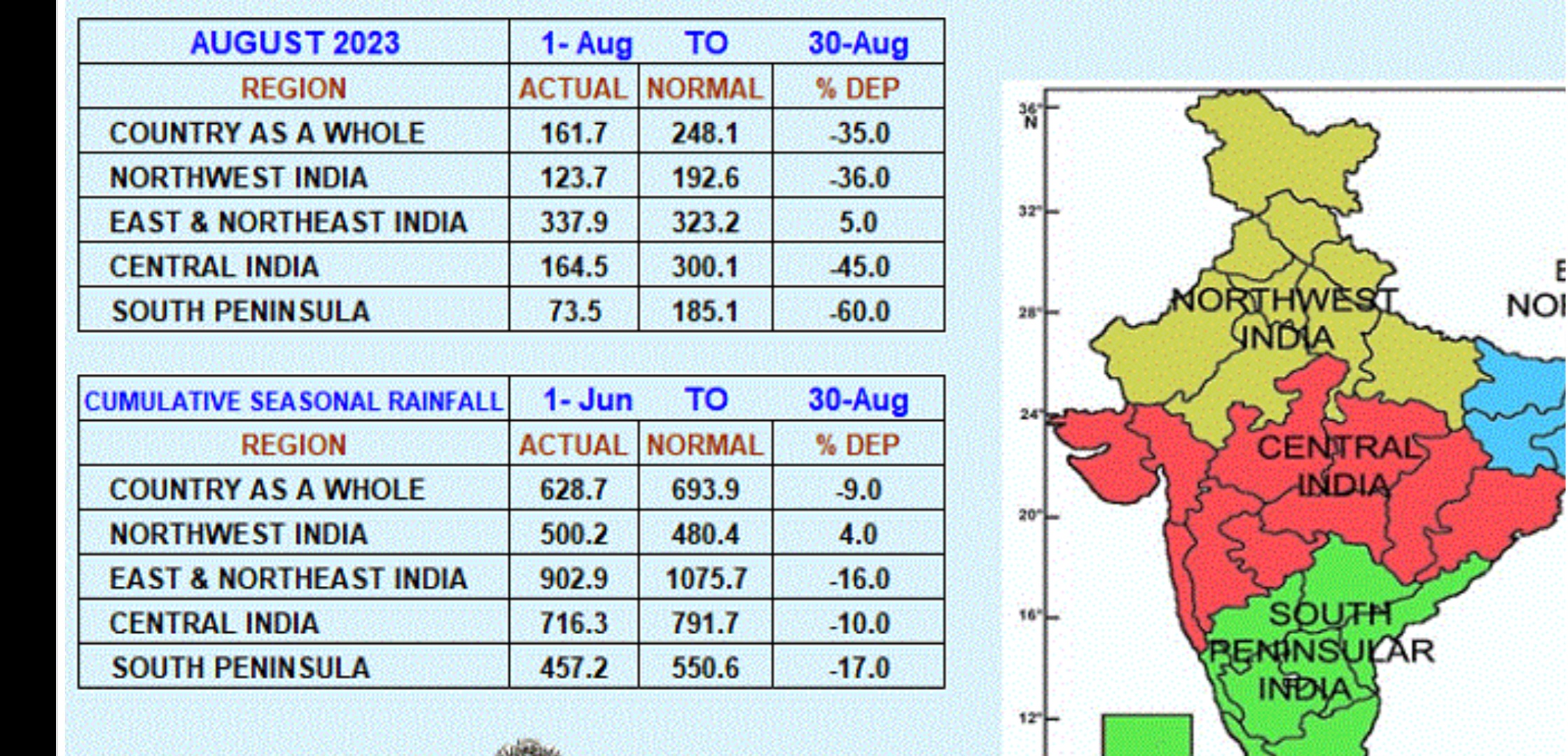
August Rainfall deficincy shows -40%...resulting in Overall Deficiency slipping to -6%. 


Vineet Kumar: 

Northeast Delhi slipped in large deficit category today with 60% below normal rain, wheras central Delhi is 57% excess north Delhi 33% excess

 Rain in northeast Delhi this monsoon: 179.3mm

On other hand central Delhi got 699.9mm rain

No meteorologist i believe has an answer to this see saw 😬

 North Delhi: 508.7mm

Kerala facing a massive rain deficiency of 44% this monsoon with only 878mm rain so far.

Next 10 days equally terrible for Kerala.

Record of lowest rain for Kerala was way back in 1918 when Kerala recorded only 1150.2mm rain.

Are we going to see new lowest rain record for Kerala this monsoon. 

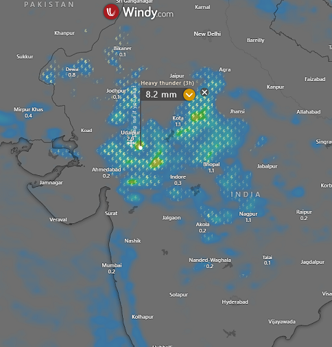
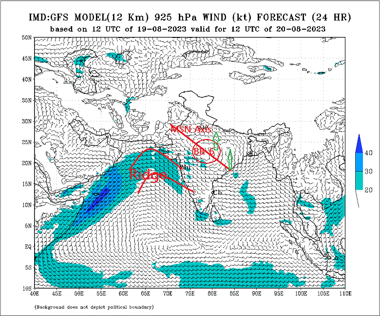
But there is light on the horizon...BB-6 , Low in the Bay has formed, which can track inland, and "force" the now stuck Monsoon Axis Southwards.

BB-6 expected to move inland and bring, a partial recovery in rainfall , in Chattisgarh, Odisha, M.P, and Maharashtra.

Mumbai: After amongst the wettest July, a dry august with only 33 mms ( Colaba) of rain and 31 mms ( Scruz) measured at in August..(Normal for the full month is 561 mms)...Lowest on record for August is 83 mms (Colaba) & 109 mms in 1972 (Scruz).

Partial increase in rainfall from Sunday 20th. is seen. Can continue with increased rainfall into next week. Thunder possible next week.. .will this help in some recovery ?

Panvel/Navi Mumbai: Partial increase from this weekend ( 19th onwards) into next week ( 19th - 24th). Rainfall could measure upto 10-30 mms /Day next 4/5 days.

 मुंबई: जुलैमधील अधिक पावसानंतर, ऑगस्टमध्ये केवळ ३३ मिमी (कुलाबा) पाऊस आणि ३१ मिमी (सांताक्रूझ) पाऊस पडला..(संपूर्ण महिन्यासाठी सामान्य ५६१ मिमी)...ऑगस्टसाठी रेकॉर्डवरील सर्वात कमी आहे १९७२ मध्ये १०९ मि.मी.

रविवार २० ऑगस्ट पासून पावसात अंशत: वाढ होइल. पुढील आठवड्यात पावसाचा जोर वाढू शकतो. पुढील आठवड्यात मेघगर्जनेसह पावसाची शक्यता आहे... .यामुळे काही प्रमाणात भरपाई होण्यास मदत होईल का...हे पाहाव लागेल.

 पनवेल/नवी मुंबई: या शनिवार १९ ऑगस्ट व रविवार २० ऑगस्ट पासून पुढील आठवड्यात (साधारण १९- २४) पावसात वाढ होईल. पुढील ४/५ दिवसात १०-३० मिमी/दिवस पाऊस पडू शकतो.

Pune: Partial increase seen in rainfall next week. Pune rainfall amounts are very low this year, with only 258 mms this season..58% of the normal till date.

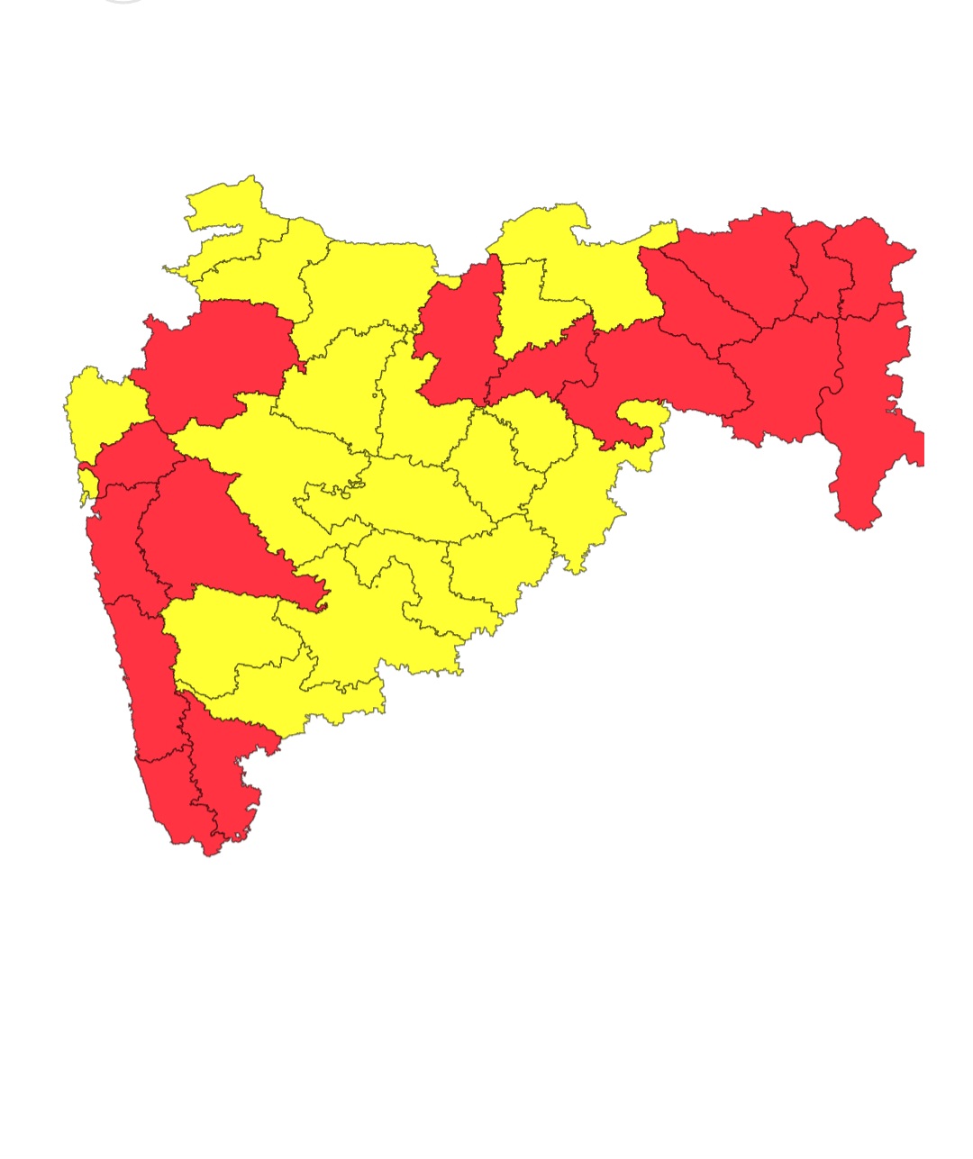
Aurangabad Region: Very little, or no rain , seen in August till date. Field crops need immediate watering . Some increase in rainfall seen from the coming low pressure. Will see moderate showers on Saturday/Sunday 20th  (20 - 30 mms) and Monday 21st will see some light showers. Though less, can help the standing crops. but much more is needed.

औरंगाबाद विभाग: ऑगस्टमध्ये आजपर्यंत फारच कमी पाऊस झाला, व काही भागात पाऊस पडलाच नाही. शेतातील पिकांना त्वरित पाणी देणे आवश्यक आहे. येणाऱ्या कमी दाबामुळे पावसात काही प्रमाणात वाढ अपेक्षित आहे. 

शनिवार/रविवारी १९/२० ऑगस्ट रोजी पावसाच्या मध्यम सरी पडण्याची शक्यता आहे (२० - ३० मिमी) आणि सोमवार २१ रोजी हलका पाऊस पडू शकेल. पावसाचे प्रमाण कमी असले तरी उभ्या पिकांना मदत करू शकते. पण अजून पावसाची आवश्यकता आहे.

Vidharbh: With the BB-6 moving in, rains will increase in Chandrapur, Gadchiroli, Nagpur, Bhandara , Gondia , Amravati and Akola regions. 

Could be heavier over the Eastern districts.


Tuesday, August 15, 2023

15th August 

Straight 9 days now ..Intense break monsoon conditions continue....

Shri Madhavan clarified about "Break Monsoon "

"The longest consecutive break spell was 18J-3A in 1972, a deficient year. In July 2002, 24 days were break days."


Courtesy Vag.Gokul...

Sunday, August 13, 2023

Posted 13th August:

The Monsoon Axis is positioned North of its normal position. Stubbornly stuck since 10 days near the Himalayan foothills. 

This thus creates a "Break Monsoon " phase. Low rainfall hence is seen in Central India, which includes Maharashtra. 

This "Break Monsoon " is Normal in August,  and records show it can remain for as long as 21 days. However, we expect the Axis to move South by 19th.

This year, we estimate the condition, of lower rainfall in Maharashtra (and Mumbai) to remain till 19th August. 

Mumbai:  The season's rainfall today at Santacuz at 2348 mms (+667 mms), for this day. Colaba seasonal total 1785 mms ( +268 mms).

July had very good, excessive, rainfall breaking the Monthly all time record with 1768 mms,

August has gone dry. Actually it seems comparatively drier after getting surplus. So far in 13 days, August  Mumbai Scruz has got only 30 mms send Colaba 28 mms. (Normal for the whole month is 561 mms). The driest August on record was in 1972, when the month received 108 mms. 

But, we still have 17 days to reach the normal August quota of 561 mms. mms. 

Days have become warmer, reaching almost 32c, and nights are stuffy at 26/27c.

Next week, till 18th at least, Mumbai is not expected to see any recovery in the rainfall intensity. The week will get scanty and patchy showers.

Lakes and Dams:

We may see some drop in levels next week with consumption continuing and taking evaporation into consideration. But, with 50 days of Monsoon remaining, we have hopes.

The Lakes supplying water to Mumbai are The Mumbai lakes and dams level reported is  (82 %) of the total. 

Last year on 11th August 2022 was (94 %) of the total 

In the year 2021 on 11th August 2021 was  (81 %) of the total.

--------------------------------------------

Rainfall for Northern States - Outlook till 16th August:

Continuing with our earlier "Lookout":

As the Monsoon trough will remain close to the Himalayan foothills for next 1-2 days, there is a chance of very heavy rainfall across the low and mid-ranges of Uttarakhand and heavy rainfall for parts of Himachal Pradesh and Jammu regions for next 24 hours. 

Parts of Punjab, Haryana and Delhi NCR may also see moderate rain/thundershowers in patches during evening of 14th to night of 16th August. 

Friday, August 11, 2023

A New Research by IITM & IISER (available to Vagaries) shows El Nino and Indian Summer Monsoon not Inter-dependent:👇

Tracking the Changing El Niño-Monsoon Relationship across Regions and Timeframes 

The monsoon rainfall exhibits a strong relationship with the El Niño, but is different across regions over India and has varied over timeframes during the last century, reports a study led by Roxy Mathew Koll of the Indian Institute of Tropical Meteorology (IITM), Pune. 

In the study published in the journal Scientific Reports, the researchers report a significant change in El Niño–monsoon relationship over the north, central, and south India. 

They find that while the El Niño–monsoon relationship has stayed moderately strong and stable for south India, it has become exceptionally stronger over time for north India, while it has considerably weakened and become non-existent over the central Indian region (core monsoon zone) in the recent decades.

These changes in the ENSO–monsoon relationship are regionally non-uniform. 

Over south India, there is no considerable variation in the ENSO–monsoon relationship. Whereas over north India the ENSO–monsoon relationship is becoming strong in recent decades. 

On the contrary, association between the rainfall over central India (core monsoon zone) and ENSO has diminished in the recent decades

Regional variability over time The ENSO impact over the Indian subcontinent is not the same everywhere. The relationship between ENSO and monsoon has not remained the same throughout the period from 1901 to the present. We notice that the ENSO–monsoon relationship started getting stronger from 1901 to 1940, became stable from 1941 to 1980 and then the relationship has weakened in the recent period (1981 onwards). These changes in the ENSO–monsoon relationship are regionally non-uniform. Over south India, there is no considerable variation in the ENSO–monsoon relationship. Whereas over north India the ENSO–monsoon relationship is becoming strong in recent decades. On the contrary, association between the rainfall over central India (core monsoon zone) and ENSO has diminished in the recent decades


The research was conducted by Athira K.S., Panini Dasgupta, Saranya J.S., and Vineet Kumar 
Singh at IITM, Pune, under Koll’s guidance, in collaboration with Raju Attada at IISER Mohali.


Thursday, August 10, 2023

Posted 10th August:

As mentioned several times, the Monsoon Axis , creating a "Break Monsoon" condition in large regions of India , is persisting. 

Resulting in low rainfall and rising temperatures in NW India and Coastal A.P. and T.N.


Now, for the weekend 10th- 14th August, we see the Axis stubborn in its Northern location. 
Result: Low rainfall intensity continues in Central and Peninsula India, at least till 15th.

Maharashtra, Gujarat and Karnataka will see very minimal rainfall.

Mumbai: This weekend will get very little rainfall, with maybe a short burst in small pockets. around 5-7mms.
With the Lakes at 82% (as on 10th), we feel its ok as yet. But beyond 15th, if it remains dry, we may have to consider the levels drop intensity due to consumption and evaporation.

Pune: Light rainfall this weekend

Marathwada: Very little rainfall expected till 14th. Drying conditions in the fields. May require some watering after weeds removal. 
--------------------------------------------------------------------------------------------------------------------------

We find a new study on the El Nino and Indian Summer Monsoon connection..a study and report is available to Vagaries. Shall be summarized and put up on 10th Evening. 
Interesting reading for Meteorologists and everone interested.

Tuesday, August 08, 2023

 8th August 


Monsoon Break is officially showing. The actual rainfall graph on top shows the rapid reduction in rainfall in the recent days.

Oh..😞

Surface chart analysis shows the Break Monsoon features. Ridge sitting near West Coast of India and Indo China peninsula ,Andaman Sea, a trough sitting along east coast of India.


Analysis by Vag.Gokul

Sunday, August 06, 2023

Posted 6th August Night:

Synoptic Scenario: The Monsoon Trough Lies North of its normal Position. typical of "Break Monsoon" scene with "Ridges"....Likely to remain the till 11th August.


(Vagarian Gokul Twitter)


Heavy Rainfall Expected in Gangetic Plains of U.P. and Bihar. Potential flooding in Gangetic Plains next week

-------------------------------------------------------

Mumbai: Looking at the rains last 4 days, 

MUMBAI CITY : Daily.   .August 1st  -5th August 👇

COLABA   mms           1.8,    10.8,    0.6,    1.6,    2.6,    0.0,

SANTACRUZ -mms     2.6,     2.0,    1.4,     3.6,    6.3     0.3

*We feel the same trend will continue next week. ( 7th -11th Aug.)

*The Monsoon will be weak with scanty showers. Upto 7-10 mms/day. Days around 28/29c

*Most rainy will be after Saturday 12th. 

Pune/Aurangabad: Partly cloudy and maybe warm and sunny. With very little rainfall.

Aurangabad farmers: With some watering later in the week. need weeding and cleaning before watering.

Goa: Light to moderate showers during the week. Not exceeding 10-12 mms/day.

Jalgaon: Week will be sunny and light to medium rains..around 7-10 mms/day.

Posted 26th April 2024... Currently, no indications of any Severe Heat Waves or highly above normal temperatures this season... And currentl...