"Phet', now tired,has never-the-less spent out its fury in Pakistan today.With gusty winds,there was very heavy rainfall in Southern and Coastal Pakistan since last night. Some of the rainfall amounts from Pakistan in mms, Gawader 227mm, Jiwani 194mm, Pasni 139mm,Karachi Masroor 133mm,Faisal 92mm, Sadar 92mm North Karachi 86,Karachi Airport 77mm, Landhi 66mm,Gulistan-e-Johar 61mm, Turbat 43.3m, Padidan 24.0,Nawabshah 22.0. Resultantly,all the heat wave spots are cooled down.
The system, erstwhile "phet", is now moving eastwards into India, via the Gujarat/Rajasthan international border. Its movement will bring some rain (and cheer) to the over heated desert regions and then into Haryana and Delhi, by Monday/Tuesday. By Wednesday,9th, as a weak low, it will crash into the Kumaon Himalayas in Uttaranchal. Hence, it can be presumed that finally, the system will die, but not before pouring rains in Uttaranchal on Wednesday.
Now, since this will move as a replica of a mini W.D, we must assume that no substantial increase in rainfall will be seen on the Karnataka /Maharashtra coasts till the 10th. of June. By 10th. June, Monsoon will just about totter to reach Konkan, as a feeble current.
By this I mean, the rainfall along the Karnataka and Konkan regions of the West Coast will continue to be meagre, and not really gain intensity till the 10th. The obvious assumption is also the fact that the interior regions of Maharashtra and Northern Karnataka will remain practically dry till the 11th of June.
The current MJO forecasts are still not very encouraging, and show the wet spell approaching the Northern Indian Ocean around the 15th. of June.But,at this stage I will not venture to comment on this, and have put in a word of caution mentioning this point in my previous blog.
The Bay has suddenly buzzed with activity today.Thick clouding is seen in the central bay, around the Andaman Islands, and the region must be watched for a "low" next week. On the synoptic situation, we can estimate some rainfall, moderate, along the Chennai coast till Tuesday, after which we see a 2 day dry spell. The same with the interior.After that,we must monitor the Bay for further estimates.
As if in defiance, an inland vortex is seen forming in the Goa region on Friday. Forecast models estimate varying amounts of rain in Goa due to this formation on Friday/Saturday. Forecasts vary from 50 mm/day to 150 mm/day.This small system is then seen moving into the Arabian Sea, and increasing rainfall over Konkan on the 12th.
Hottest in Asia: Al Ahsa Airport (Saudi Arabia), 48° and Basrah (Iraq), 48°
Hottest in India: Jharsuguda;45.5c.
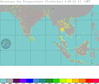
Most of the hottest regions have got the much needed relief, thanks to the system, now travelling East into India. The map showing today's highs says it all.
Mumbai: High today at Colaba:36.0c,and at Santa Cruz:34.2c.Santa Cruz recorded 7.8mms of rain while Colaba had just 0.4mm.
Increase in rains expected temporarily for a day today, but the real increase in rain intensity will be from the 10th.
Vagaries© of the weather.blog written by rajesh kapadia & co-authors concentrating on meteorology of the Indian sub continent and extreme world weather since 55 years For Any Information taken from here, due credit must be given to Vagaries.
Co Authors: GSB, Shreyas Dhavale, Pradeep John, Dr. Vineet Singh, Gokul
Sunday, June 06, 2010
Subscribe to:
Post Comments (Atom)
16th April: Pune – Large Diurnal Swing Continues Max: 39.7°C (102°F) Min: 17.1°C (63°F) Diurnal Range: 22.6°C (≈ 41°F) Regional Patte...

-
Short Narration: Monday 1st/Tuesday 2nd : The heaviest rains are in Madhya Maharashtra, Marathwada, North Interior Karnataka and No...
-
Much Awaited Monsoon Analysis to Date from ..None Other than Our GSB..on "Stats and Analysis" Page..Just Recieved On Saturday ...


4 comments:
Am again asking the question - there were very heavy rains in Mumbai on 8th and 9th June in the year 1991. Does any one have an idea what event caused it? Can't find this event chronicled any where. Many thanks.
It is pouring sheets of rain with howling wind here at Andheri. Is this not Monsoon already?
I'll check up and see if I can find some reference to your 1991 query. Shall come back thru blog or if you give your mail.
second comment. No, this is not the monsoon, but inflow effect of depression over N.India (Phet). I stick to my forecast given on 6th.
Rains will increase from 10th. ,the Monsoon date...
Thanks Rajesh, appreciate your kind help. You can either post it here in the Blog or you can mail me n_cthaker@yahoo.com
Post a Comment