Posted 19th March 2019
Have posted on this page after a very long time ...big gap :-)...anyway, the main page has always kept the latest Mumbai weather updated...
Mumbai is having, almost normal , and nights slightly cooler, (and quite happy about it) weather since the last week...as the graph shows.
 Expected to continue in the same range, 32/33c-20c for the next 3 days. Expecting temperatures to rise from Saturday by a few degrees, as well as increase in humidity levels.
Same reasoning with Pune, expect that the day is a degree above normal, but compensated by the night, which is a degree below normal.

---------------------------------------------------------------------------------------------------------------------------------------------------------------------------------------------------------------------------------------------------
Posted 10th December 2017:
Monitoring Mumbai's Mangroves:
 Mar 19th 1988
 Jan 30th 2017
------------------------------------------------------------------------------------------------------------------------------------------------------------------
Posted 27th July 2017:
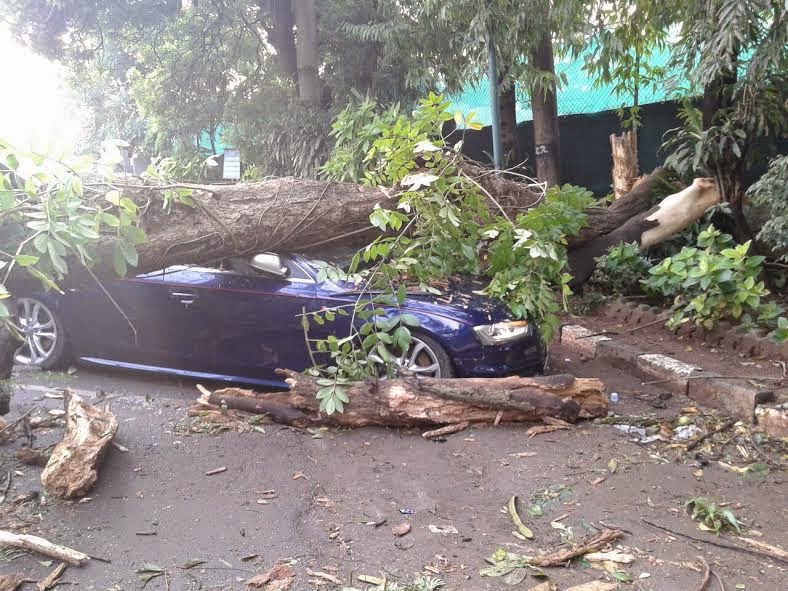
It was 12 years ago , when Mumbai was lashed and drenched with a record breaking rain event.....
A day Mumbai will never forget
Refreshing the memories of the 26th July 2005 event of extremely heavy rains in Mumbai region with a Map of the rains around on that day.
24 HOUR RAINFALL EXACTLY 12 YEARS AGO
 And How and why it happened...

----------------------------------------------------------------------------------------------------
Posted 3rd July 2017:
Map compiled by Vagarian Tejas from Data provided by Vagarian Abhijit Modak.

Posted on 2nd July 2017:
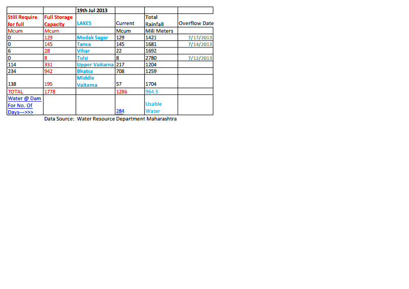
Lakes Supplying water to Mumbai rains and levels:
Rainfall total in lakes for June 2017:
Tansa: 955 mms, Modak Sagar 801 mms, Bhatsa 942 mms, U. Vaitarna 665 mms and M.Vaitarna 853 mms.
Storage level total as on 1-7-2017 is 554 Mcum. At 3.8 mcum per day, Mumbai has water stored for about 145 days, that is upto 25th November 2017.
Info by Vagarian Jayesh Mehta.


---------------------------------------------------------------------------------------------------------------------------------------------------------------------
Posted 2nd June 2017 Night:
Forecast for Weekend:
Mumbai:
The pre Monsoon thunder showers predicted for 2nd June by Vagaries have commenced. On Thursday and Friday evening/Night, parts of Mumbai got light/moderate thunder showers. On Thursday Night, Santa Cruz managed 8 mms , Colaba 6 mms, while our Vagarian at Dadar recorded 3 mms. Here at Vagaries there was 0.2 mms.
Saturday and Sunday: After a sunny day, Clouds developing in the afternoon/evening. Some thundery developments in the eastern skies. Some sectional drifting towards city will bring light to moderate thunder showers in some parts of the city. Areas where it rains may get around 5-7 mms.
Some regions in the Eastern and Northern outer townships may get moderate showers.
Pre Monsoon showers will prevail in till next week at least. Regular Monsoon should come as per our expectation around end of next week.
Pune can get a thunder shower this Saturday and Sunday towards evening/Night. Rainfall upto 8-10 mms expected.
Similar thunder showers expected in Aurangabad and Mahableshwar on Saturday and Sunday.
------------------------------------------------------------------------------------------------------------------------------------------------------------------------------------------------------------------------------------------------------------------------------------x----------------------------------------------
Posted 24th September 2016

Posted 17th September 2016
Mumbai Water Position 17th September: Lakes supplying water to Mumbai have a total storage of 1414 Mcum out of a full capacity of 1448 mcum, meaning 97% full. At current levels, Mumbai has a year's supply stored.
Maharashtra Water Storage: Overall Storage in 69.5%.
Konkan Region 92%, Marathwada Region 38%, Nagpur Region 69%, Pune Region 80%, Amravati Region 65%, Nasik Region 72%.
---------------------------------------------------------------------------------------------------------------------------------------------------------------------
Posted 10th August Night:
A good Monsoon this year has brought cheer and good Lakes Storage for Mumbai City.
The total storage as on date is 1292 Mcum, that is 90% full Storage.
In other words, Mumbai has water till 17th July 2017 as of today...Info from vagarian Jayesh Mehta.
Map below shows the Lakes Storage and Total rainfall os of date of the Lakes.Compiled by Tejas


------------------------------------------------------------------------------------------------------------------------------------------------------------------
Posted Saturday 6th August
Mumbai region rains as on 6th Morning:
 compiled by Vagarian Tejas
Posted Wednesday 3rd August
Incessant rains lashed whole Nashik district. Rain triggers flood in many villages. Draught prone areas also get good rains.
Some massive rainfall of Nashik district recorded till 8:30 am today on 3 Aug 2016.
Gangapur dam (Nashik) 413 mm
Harsul (Trimbakeshwar) 259 mm
Bhavali dam (Igatpuri) 235 mm
Trimbakeshwar 230 mm
Dhargaon (Igatpuri) 227 mm
Upper vaitarna dam (Igatpuri) 227 mm
Nashik 204 mm
Waghad dam (Dindori) 198 mm
Nandgaon (Igatpuri) 188 mm
Darna dam (Igatpuri) 188 mm
Igatpuri 186 mm
Girnare (Nashik) 186 mm
Kadwa dam (Dindori) 186 mm
Umarale (Dindori) 182 mm
Mukane dam (Igatpuri) 180 mm
From ShivKumar Mogal
Posted 1st August 2016
Compiled by Vagarian Tejas


Posted 19th July:
 compiled by Vagarian Tejas
Maharashtra Rains on 19th July from Pradeep John:
-------------------------------------------------------------------------------------------------------------------------------------------------------------------
Posted 12th July 2016:
---------------------------------------------------------------------------------
11th July 2016: Overall Maharastra 23%. ...See Below, 10 days back.
Mumbai's Tulsi Lake Overflows. Good Rains in Lakes. Total Storage of Mumbai Lakes 489 Mcum,that is 33%. With 20% cut, Mumbai has 174 days of Water Storage.
Overall Reservoirs Levels in Major Regions of Maharashtra:
Konkan 55%, Marathwada 2%, Nagpur 29%, Pune 25% , Amravati 22%, Nasik 22%.
Mumbai Rainfall till 11th July 2016: Santa Cruz 1047 mms ( + 225mms), Colaba 774 mms (-69 mms).
Thane 1279 mms,Pune 249 mms and Mahableshwar 1918 mms.
-------------------------------------------------------------------------------------------------------------------------------------------------------------------------
Details from Vagarian Abhijit Modak
Maharashtra overall available live water storage is on only 9% as of 30th June 2016.
Division wise storage:
Konkan 29%
Nagpur 17%
Amravati 11%
Other Dam's 9%
Nashik 8%
Pune 7%
Marathwada 1%
Mumbai overall dams storage is on 20%.
Thane District all cities water supplying dams storage:
Barvi dam 9%
Andhra dam 6%
Mumbai & Thane District water supplying dams total rainfall for June 2016 (1st to 30th June 2016):
Vihar 899mm
Tulshi 825mm
Modaksagar 240mm
Bhatsa 222mm
Tansa 208mm
Middle Vaitarna 164mm
Barvi 146mm
Andhra,Maval 90mm
Upper Vaitarna 83mm
Except Vihar & Tulshi rainfall (as it is on coastal) .. Rest other dam’s rainfall looks like 24hrs figure but in reality they are whole month rainfall!!
Some Ghats section (near Mumbai) total rainfall for June 2016 (1st to 30th June 2016):
Bhira 616mm
Mulshi 499mm
Mahabaleshwar 461mm
Khandala 332mm
Lavasa 242mm
Bhimashankar 232mm
Lonavala 231mm
Igatpuri 197mm
----------------------------------------------------------------------------------------------------------------------------------------------------------------
--------------------------------------------------------------------------------------
cloudy on Saturday 20th february, 2016..Pics taken by vagarian Salil


Posted 2nd February
Image of recent smog over Mumbai..

Posted 27th December 2015


--------------------------------------------------------------------------------
---------------------------------------------------------------------------------
----------------------------------------------------------------------------------------
Posted Friday 27th November 2015
Saturday:
 Partly Cloudy and hazy sky.
 Getting cloudy, with some light rain in parts of city by evening. Rise in night temperatures.
Sunday:
 Partly cloudy , and day temperatures around 31/32c.
Last 30 Days Temps in Mumbai...and the Normal Variation Diagram Below


---------------------------------------------------------------------------------------------------
---------------------------------------------------------------------------------------
-----------------------------------------------------------------------------------------
Posted 7th November 2015
Mumbai heat for the last 30 days...7th Oct-6th November


Posted 24th October 2015:
Absolutely un bearable Heat Wave in Mumbai...October Heat, Worst than May Heat !!
Last 10 days have seen an abnormal and Unseen Heat Wave of Mumbai ..
Mumbai : Heat and record Heat, Last 10 days days>>>
Scruz:(October)
24th 36.8c - 24.8c Colaba 33.7c - 27.3c
23rd 35.3c - 24.6c Colaba 33.9c - 28.2c**
22nd 36.4c- 23.6c Colaba 34.9c - 27.7c
21st 37.5c - 23.9c Colaba 36.2c - 27.2c
20th 37.1c - 24.2c Colaba 35.4c - 27.4c
19th 37.5c - 25.3c Colaba 35.8c - 27.8c
18th : 37.4c - 25.7c Colaba 33.5c - 28.0c
17th: 37.5c - 25.6c Colaba 36.1c - 27.6c
16th: 38.6c* - 22.4c Colaba 34.8c - 26.5c
15th : 37.2c - 25.4c Colaba 34.8c - 27.4c.
* Record All Time High for October ** Record Night High for October
The Heat in Mumbai...As it started increasing....Oct 9th-Oct 23rd

And the Humidity...

The above Normal details of the Last 30 days...the Red region seen last 10 days...

--------------------------------------------------------------------------------------------------------------------------------------------------------------------------------------------------------------------------------------------------
Mumbai : Heat and record Heat last 6 days >>>
Scruz: October
20th: 37.1c - 24.2c
19th 37.5c - 25.3c
18th : 37.4c - 25.7c
17th: 37.5c - 25.6c
16th: 38.6c* - 22.4c * Record All Time High for October
15th : 37.2c - 25.4c
Colaba: October
20th 35.4c - 27.4c
Tuesday 20th October Morning... Mumbai:

Mumbai Water supplying Lakes Position as on 6th October 2015:
Total filled of all lakes 81%: 11,70,000 mltrs. (Full: 14.43 lmltrs).
At the supply rate applying 20% water cut as on today, we have water to last 365 days...upto 5th October 2016. At Full supply, if the cut is not applied, there is water for 310 days, that is upto 15th August 2016.
Monthly & Monsoon Performance depicted by Vagarians Displayed Below:
From Vagarian Abhijit Modak:

 From Vagarian Junaid

 From Vagarian Puneet:
From Vagarian Tejas:

--------------------------------------------------------------------------------------------------------------------------------------------------------------------------------
Marathwada:
After a good spell of Bountiful rains from BB-6, Maharashtra is now in for an almost dry spell next 5 days. This is now beneficial for the farms and standing crops. We understand, tht the recent rains in Marathwada has resulted in almost all the small dams overflowing or to the brim. This has brought the ground water table higher, and the local wells have seen a ris eof 12-15 feet in their water levels. More rise expected in wells as the water percolates into the side bores. Even the standing crop has got enough soil moisture till harvest time. This late rainfall was more helpfull as it was accompanied by lightning. Remember, that when lightning flashes across the atmosphere, it momentarily "consumes" up most of the oxygen from the air, resulting in a temporary increase in Nitrogen in the air space. This Nitrogen dissolves in the falling rain, and as we all know, Nitrogen is a very useful fertiliser for crops.
Retreating thunder showers are likely in interior Maharashtra after next Monday 28th September.
Mumbai Lakes Position as on 20th September 2015:
Middle Vaitarna Overflows..Water Diverted to Modak Sagar
Lakes Full Level Todays Level Short Storage Total Rainfall
Modak Sagar 163.15 162.86 -0.29 1.27 1693
Tansa 128.63 127.56 -1.07 1.25 1635
Vihar 80.12 76.97 -3.15 0.12 1941
Tulshi 139.17 139.02 -0.15 0 .08 2208
Upper vaitarna 603.51 603.48 -0.03 1.23 1804
Bhatsa 142.07 133.13 -8.94 4.90 1874
Middle vaitarna 285.00 284.30 -0.70 1.90 1895 *
* On Friday 18th, Reached full level, so water was released into the Modak Sagar
Total Available 1075254 mltrs (10.75 mltrs)....@ 3200 (0.032)/day (with 20% cut), we have 335 days water storage as on 20th September...That is up to August 15th 2016.
Out of 7 lakes, 4 are less than 1 meter below overflow ,1 is less than 2 meters from over flow, 1 around 3 meters and main supply Lake Bhatsa is 9 meter below overflow mark.
If it rains like yesterday three dam will overflow overnight hopefully
Information compiled by Vagarian Jayesh Mehta.
If we see the Position of 15th September, we have a storage of 9,96,000 mltrs, and on 20th September we have 10,75, 000...a rise of around 80,000 million ltrs ! In 5 days, it has rained to supply Mumbai City 25 days of water !! Nature's Bounty ...Lets be Grateful and Respect Nature..
You Need Nature...Nature Does not Need You !!
----------------------------------------------------------------------------------
Mumbai Water supplying Lakes Position as on 19th September:
Total filled of all lakes 72%: 10,40,000 mltrs. (Full: 14.43lmltrs).
At the supply rate applying 20% water cut as on today, we have water to last 325 days...upto July 30th 2016.
Mumbai Water supplying Lakes Position as on 15th September:
Levels in % as full:
Bhatsa 71%, Vaitarna 66%, Modaksagar 84%, Tansa 83%, Vihar 43%, Tulshi 100%, Middle vaitarna 98%.
Total filled of all lakes 69%: 9,96,000 mltrs. (Full: 14.43lmltrs).
At the supply rate applying 20% water cut as on today, we have water to last 311 days...upto July 20th 2016.
Certainly not comfortable, as levels will fall drastically from April, and we have consider the timely arrival of next Monsoon.
None of the Lakes received rainfall in 24 hrs ended 8.30 am 15th September.
Mumbai Water Supplying Lakes Storage as on31st August 2015 ..
Mumbai has about 985 Mcum water storage in all it supplying lakes, that is about 68% full. At the rate of present supply, without cut,Mumbai has a storage of about 262 days, that is till about 20th May 2016.
With Water cut implemented, the water is now available for 301 days, that is till 30th June 2016
Mumbai Water Supplying Lakes Storage as on 25th August 2015 ..
Mumbai has about 935 Mcum water storage in all it supplying lakes, that is about 64% full. At the rate of present supply, Mumbai has a storage of about 250 days, that is about 25th April.
Mumbai Water Supplying Lakes Storage as on 13th August 2015 ..
August Details of Mumbai Eastern Outer Townships and Botivali sent by Vagarians' Private Stations:
Puneet sends Konkan Rains 2015

Badlapur from Abhijit 2015:

Panvel from Junaid


---------------------------------------------------------------------------------------------------------
---------------------------------------------------------------------------------------
Mumbai Lake Storage in Mcum as on 29th July:
Bhatsa 521 , vaitarna 164 ,Modak sagar 111, Tansa 80, Vihar 10 Tulsi 7, Middle Vaitarna 174.
Total Storage 1067.
Allowing 33% for leakages, wastage, evaporation etc, we have 711 Mcum remaining for distribution.
At 3.75 supply per day, Mumbai has 189 days supply. That is about 6 months supply.

Full Capacity Current Levels (McuM)
Bhatsa 942 258
U.Vaitarna 331 51
M.Vaitarna 195 194
Modak 129 52
Tansa 145 12
Vihar 28 1
Tulsi 8 2
1778 480 (27%)
Supply Rate at 3.7 MCUM to city, Mumbai has about 95 days supply, or lasting till 15th September 2015. This is at present supply rate.
25% deducted for Drawable levels, Wastage in transit etc......


Presuming the Daily Consumption and Supply at 3850, as what is known last,, We have Stock of about 200 days.


 Mumbai
 Badlapur
 Seen from South Mumbai
 Thunder heads at Badlapur

Marathwada , at the end of September, was at -42%, having received only 399 mms against a normal of 683 mms.
Total live storage of all dams in Marathwada is ok at around 75%.
However, some sporadic thunder showers in the first week of October have added soil moisture and will help the rabi crop.
Jayakwadi, the main and huge source of water storage was better placed than in 2013 and 2012.
This year, the storage level is 45% of the full, better than 33% last year and much much better than only 3% in 2012 !
The level of Jayakwadi is critical and important, but is controlled by discharges from dams in Nashik, and sometimes outflows are allowed from Jayakwadi for downstream.
Crop wise, almost 40-45% of the Kharif crop has withered due to poor rains in Monsoon (Marathwda).


--------------------------------------------------------------------------------------------------------------------------------------------------------------------------------------------
Come Saturday Evening, and the forecasted Thunder storms came..
Heavy Storms reported by Junaid, Abhijit and Puneet from Eastern Outer Townships of Panvel, Badlapur and Dombivali.

Pic sent by Junaid and Abhijit.


Vineet and other vagarians tell of heavy showers in Pune.
Steady drizzle with Thunder here in South Mumbai since 6.00 pm IST
----------------------------------------------------------------------------------------------
Thursday Morning,21st August, Mumbai got a surprise thunder shower around early morning....A Vortex in the upper atmosphere near Mumbai caused a short but severe thunder shower in Mumbai. Lasting 2 hours overall on Thursday morning, the peak rainfall from 7 am to 8 am brought the major rainfall. Vagaries 38 mms, Colaba 33.6 mms and Scruz 29.6 mms.
Dadar recorded 96 mms, Worli 81 mms, Dharavi 55 mms.
Min remained high at 27c...and yesterday was odd with max at 27.8c, and min Wed morning was 27c.


Posted Tuesday 19th Night:
Follow up of Monday afternoon's Forecast.....
Thunder Showers Activity from Nasik Southwards to Kolhapur as explained yesterday..

Mumbai was very cloudy, but as expected, just 1 mms of rain at Scruz.
Pune , being in the Thunder activity zone, saw 23 mms till 5.30 pm Tuesday.
Delhi day soared to 37c Tuesday.
Posted Monday 18th Afternoon:
------------------------------------------------------------------------------------------------------------------------------------------------------------------------------------------------------------------------
-----------------------------------------------------
Thanks Jayeshbhai
Posted Monday Evening: As forecasted, the maximum Temperature jumped to 35.8c at Scruz on Monday.....
Mumbai City may get the Pre Monsoon showers ( Thunder) from 1st/2nd June onwards
Posted Sunday ( 18th May) Evening:
Mumbai: Next 4 days....19th May - 22nd May.
Partly Cloudy days. Seeing some towering Thunder heads in the East on Monday 19th. Some drifting of alto cumulus in the evening from the East. Nights will be partly cloudy and stuffy, humid and sweaty. North/North-West winds will be sharp in the evening at around 25-30 kmph.
Hotter next 2 days in the week ! As the humidity increases, with passing day,warmer real feel temperatures will make the day sweaty.
Temperatures will be between 36c and 28c on Monday and Tuesday. But, humidity more and temperature less on Wednesday and Thursday..at 34c and 28/29c...so harsher real feel !
On Sunday evening, Eastern Outer townships got a dust storm with thunder. Matheran received rains (about 8 mms as per unofficial report). Intense rains seen around Matheran and rain patch in the North...

Eastern Outer Townships:
Possibly will see some Cumulus developments on Monday 19th, and with cloudy skies, night temperatures will show a rise as they get stuffy.
Tuesday, the outer towns will be hot, and with the temperature at 37/38c and humidity at 65%, its going to be un comfortable. Nights warming up to 27/28c.
Temperatures shift down 2 degrees from Wednesday.
Pune: Partly cloudy. Tuesday 20th some Cumulus developments in some parts. Otherwise, days will be around 40c, and nights rising to almost 25/26c.
------------------------------------------------------------------------------------------------------------------------------------------------------------------------------------------------------------------------------------------------------------------------
Posted Saturday Morning:
Mumbai, Saturday 26th, Sunday 27th and Monday 28th will not be as comfortable as the temperature readings will show.
The day's Max on these 3 days will not go over 34c. Ok, good !. But the high humidity that will sweat the city will be around 70-80%. This will make a Real Feel temperature of around 39/40c in Mumbai.
W/NW winds will bring in cooler sea breeze, and a good lot of humidity with it. In fact, we have WNW winds upto the 850 level over Mumbai, and a ridge at the 700 level. This will surely block the humidity and warmth on the ground level.
So, as a result, the nights will be around 27c...warm and stuffy !
Clear skies.
-------------------------------------------------------------------------------------------------------------------------------------------------------------------------------------------------
Thanks Jayeshbhai
--------------------------------------------------------------------------------------------------------------------------------------------
Posted Thursday 15th Night:
Mumbai finally showing signs of reducing temperatures...Maximum on Thursday was 36 5c at Scruz ( reduced by 2.5c from Tuesday) and it was 33.4c at Colaba, educed by 3c.
As mentioned earlier, we can expect the mercury to reach 35c by Friday. Expect NW winds to bring in sea breeze and bring the temperatures down...and the humidity up !
The minimums are also as per our estimate, 26.4c at Colaba and 25.0c at Scruz.
Posted 24th April:
And Mumbai Het continues for the 4th day running....
Query from Abhijit: " Sir : Why so much of heating in just 30 -40kms inland to ARB sea this year ? Int Maha areas like Nashik, Pune Aurangabad yet to see their first 40c temp ! And we in interior coastal Konkan had 40c+ for 5 times ! 4 of them in Apr itself..?"
Well, this wind chart explains it all...
..
The wind Chart..shows NE winds in the Northern Coastal (West)
means bringing very dry NE winds and pushing away the sea breeze and humidity...there is a ridge along coast at upper level that is preventing hot air from rising, and cool sea breeze not able to enter coast, so even the konkan interior heats up..ridge always stubborn and hot in this month...
That is why even the nights are warm, Vagaries recorded a min of 28.4c on Wednesday morning and 28.0c on Thursday.
Surat was 41c and many North Konkan Cities like Thane, Kalyan and Badlapur were over 40c.
------------------------------------------------------------------------------------------------------------------------------
Posted 22nd April 2014:
Northern Suburbs of Mumbai received light showers on Monday , 21st April night. Parts of Ghatkopar, Goregaon, Sion and Vikhroli got medium showers with tunder. Thane, ad surroundings too received good showers in the night.
Panvel and Badlapur reions received light drizzles late at night. Navi Mumbai received heavy showers with thunder.
meanwhile, Santacruz soared to 39c on Monday, highest after 2009 in April when it had touched 40.6c on th 2nd of the Month. The highest ever for April is 42.2c, on 14th April 1952. The lowest minimum at Sanata Cruz ever for April was in 1968 when it dropped to 16.9c.
Colaba was 36c. The highest in April ever for Colaba is 40.6c, which was on 19th in 1955. The lowest minimum for Colaba ever was 20c in 1905.
Vagaries recorded 38.1c on Monday.
Thundery cloud developments around the ghats on Wednesday, and temperatures crossing 36c in Mumbai. Partly cloudy for Mumbai.
"Maharashtra Special" mentioned on Thursday for Sunday and Monday, now decreases. Rains decrease in intensity. ------------------------------------------------------------------------------------------------------------------------------------------------
Posted 2nd December 2013
Regions around Eastern Mumbai townships also received some showers (Karjat)...Showers will recede to South on Tuesday, and vanish by Wednesday.
The stuffy weather in Mumbai will ease from Wednesday night (Thursday morning) as we see a fall of 3/4c on Thursday morning..
Pune and some regions around Pune received Thunder showers on Monday evening.
Aurangabad got a heavy downpour of 40 mms between 10 pm and 11.30 pm IST on Monday night. Temperature dropped from 25.5c to 19c i an hour.
Low stratus and cumulus clouds were observed at a height of 300 metres only.
-----------------------------------------------------------------------------------------------------------------------------
Posted on 4th November @ 11 pm IST
Eastern Outer townships of Mumbai received light drizzles on Monday Night.
Mumbai will be warm on Tuesday at 35c, but dropping a couple of degrees from Wednesday. Winds change to NE from Wednesday.
Partly cloudy on Wednesday and Thursday, with Thunder clouds in the East.
Chances of thundery development and light shower in Outer townships (Eastern) on Wednesday and Thursday.
Cooler temperatures from Friday, seeing a drop in the night temperatures below 20c. Outer townships see a drop to 18c after Friday.
Posted on 1st November @ 11 pm IST
Mumbai:
Mumbai is the usual. Days are in the predicted 33/34c range. But, things could be a little more warmer on Divali day. East winds are going to keep the days warm at 34c, but maybe at 35/36c on Sunday. Nights will show some variation by dropping to 22/23c.
Mumbai may see some light clouding on Monday, raising the night temperature.
Pune remains partly cloudy for Divali, with days around 31c and nights at 17/18c.
-------------------------------------------------------------------------------------------------------------------------------------Posted 5th October 2013
Some not usually seen Arcus clouds over Mumbai (South)..saw these on Saturday evening and clicked on my cell....see 3rd Pic...actually they are forming on the land...just after the coastlne


Mumbai Lake Levels and Details of Lake Rains from JayeshMehta. ..28th September 2013


Figures of Konkan August Rainfall from Abhijit:
Some Konkan coastal places lowest rainfall recorded for Aug 2013 :
Alibaug 161mm (66% deficit)
Murud 177mm (75% deficit)
Colaba 234mm (51% deficit )
Vasai 245mm (42% deficit)
Santacruz 255mm (52 % deficit)
Palghar 286mm (32% deficit)
Shriwardhan 296mm (60% deficit)
Aug 2013 has became lowest rainfall month in last 10 year period for Mumbai(SCZ).
Previous low rainfall was 290mm in Aug 2009.
And Information from Puneet Bangera

Jayeshbhai sends Last years Vagaries Lake Levels comparison (as put on vagaries) with today's Level


Thane District Rainfall Diagram from Rohit Aroskar and Table from Puneet:


Rainfall around Mumbai ending 8.30 am today(31-07-2013)..By Abhijit Modak
Colaba 9.0mm
Santacruz 31.0mm
Vagaries 26.0mm
Vihar(Mumbai) 40.0mm
Tulshi(Mumbai) 40.0mm
Alibaugh 7.0mm
Uran 20.0mm
Panvel 21.6mm
Karjat 77.7mm
Khalapur 25.0mm
Vasai 12.0mm
Thane 29.2mm
Bhivandi 35.0mm
Murbad 37.0mm
Shahapur 44.2mm
Kalyan 38.0mm
Ulhasnagar 46.2mm
Ambernath 40.8mm
Barvi(Badlapur) 77.0mm
Prepared by Jayeshbhai Mehta


Rainfall around Mumbai ending 8.30 am today(20-07-2013)...From Abhijit Modak
Rainfall around Mumbai ending 8.30 am today(19-07-2013)...From Abhijit Modak
Colaba 31.2mm
Santacruz 17.8mm
Vihar(Mumbai) 22.0mm
Tulshi(Mumbai) 25.0mm
Alibaugh 11.0mm
Uran 90.0mm
Panvel 45.0mm
Karjat 82.7mm
Khalapur 115.0mm
Vasai 2.0mm
Thane 22.4mm
Bhivandi 40.0mm
Murbad 60.0mm
Kalyan 36.0mm
Ulhasnagar 31.0mm
Ambernath 24.4mm
Barvi(Badlapur) 46.0mm
Mumbai Water Supply Lake Levels:
Sent and compiled by Jayesh Mehta


Saturday 13th July 2013:
On Friday, Mumbai was flooded, traffic snarled and trains were late...was it heavy rains,or mismanagement ?
The rain amounts put up below, for Friday's rain are heavy, no doubt, but hasn't Mumbai seen much more than this before ? Even double this amount is normally expected in Mumbai in June and July...anyway..
Rainfall from Friday morning to Saturday morning:
Dadar and Wadala 115 mms, Chembur 111 mms, Borivali 107 mms, Worli 104 mms, Dahisar 90 mmms, D Ward (Nana Chowk) 65 mms, Vikholi 59 mms.
IMD Colaba 49 mms, Sanat Cruz 108 mms and Vagaries 87 mms.
The average for Western Suburbs was 83 mms, Eastern Suburbs was 86 mms and Island City was 85 mms.
(The average rain amount put up by vagaries for the period was upto 55 mms (For Mumbai City, so overshooting by 30 mms).
The outer townshps rainfall will be put up by noon (by Abhijit). But from figures received for Northern Townships, Vasai recieved 133 mms till 8 pm Friday.
Lake levels and rain amounts will be put up on this page as soon as they are confirmed..anyway, why are we so excited about Tulshi overflowing. Water supply to Mumbai is 3500 mltrs/day, and only 40 mltrs is taken from Tulshi. Its like adding a bottle of mineral water in your overhead water tank...as some say "the mineral water bottle has overflowed."
x-------------------------x--------------------------x-------------------x
Rainfall around Mumbai ending 8.30 am today, Friday, 12th...posted by Abhijit Modak
Colaba 30.2mm
Santacruz 35.4mm
Vagaries 46.5mm
Vihar(Mumbai) 52.0mm
Tulshi(Mumbai) 64.0mm
Alibaugh 64.4mm
Uran 87mm
Panvel 71.4mm
Karjat 170.0mm
Vasai 87.0mm
Thane 68.0mm
Kalyan 93.0mm
Ulhasnagar 108.8mm
Ambernath 97.6mm
Barvi(Badlapur) 157.0mm
State Capitals and Mumbai June Rainfall Details Provided for Vagaries by Rohit Aroskar


Mumbai region - Top 11 rain stations June 2013(rain in cms) .. (all 11 century makers)..
Mumbai Tulshi 187 Ulhasnagar 121
Thane 119
Mumbai Vihar 117
Karjat 117
Panvel 115
Khalapur 113
Kalyan 109
Ambarnath 103
Mumbai SCZ 103
Mumbai Water Supply Lake Levels as on 18th June:Available Storage in Mcum, With % full in brackets):
Modak Sagar 34 (26%)
Tansa 61 (42%)
Tulsi 4 (50%)
Vihar 9 (32%)
Bhatsa 351 (37%)
Vaitarna 101 (31%)
Total Available Storage @ 80% = 450 Mcum @34/day = 130 days Stock.
Marathwada Dams at 226 Mcum, only 4% of total Stock. Jayakwadi Level = 0.
Total Reservoirs and Dams of Maharashtra: 18% full
Source : Water Resources, Govt. of Maharashtra.
x-------------------------------x--------------------------------x-------------------------------x
Rainfall Figures in mms for Raigadh and Thane District as on Monday Morning 17 th june
Alibaug 81
Panvel 256
Karjat 231.5
Khalapur 199
Uran 260
Sudhagad 58
Pen 188.1
Mahad 93.5
Mangaon 35.2
Roha 131
Poladpur 125
Murud 61
Shriwardhan 21
Mahasala 36
Tala 87
Tulshi lake 280
Vihar lake 169
Thane 145.6
Kalyan 127
Murbad 165
Bhivandi 115
Vasai 78
Wada 83
Shahapur 93
Dahanu 5.6
Palghar 56.2
Javhar 106
Mokhada 59.8
Talasari 23
Ulhasnagar 156.4
Ambernath 185.4
Vikramgadh 63
x---------------------x-----------------------------------------x-------------------------------x
Brief Saturday, 15th June Report as on 5.30 pm for Mah:
Cold day in Vid with days below normal by 11-12c. Coldest day at yeotmal at 24c, which is 12c below normal,and 36 mms rainfall, Amraoti at 25.2c was 11.7c below normal and Wardha with 70 mms rain was 25.8c, below by 11.1
Aurangabad was 25.4c (Max) and 8c below normal.
Mahableshwar recieved 72 mms and day's high was 18.7c (3c below normal).Jalgaon received 14 mms.
Ratnagiri managed 56 mms and while vagaries recieved 24 mms, Scruz and Colaba managed 10 mms each. (Vagaries has now gauged up 35 mms till 7 pm. Raining at time of report).
Lakes Levels supplying Water to Mumbai City as on 14th June:
Total Full Capacity Storage @ 80% 1343 Mcum...and Total available on date @ 80%: 350 Mcum.
Storage for 70 days available at full consumption without cut (Taken at 5 Mcum/Day).
Lake Wise % Storage available: Bhatsa 31%, Vaitarna 30%, Modak Sagar 13%, Tansa 25%, Vihar 21% and Tulsi 38%.
(From Irrigation Dept, Water Rescoces, Govt of Mah).
x------------------------------x------------------------------------------x---------------------------------------------x
Posted on Sunday @ 8.10 pm IST
Light rains from South Mumbai ...Dombivai and Panvel ...Monday's forecast happens on Sunday !


Posted on 31st Night...
Mumbai Water Supplying Lakes Position as on end of May....(from Mah Govt Water dept)
Current Storage : 505 Mcum.
Full Storage: 1700 Mcum (usable taken @ 80%)
Available Water: @ 80%: 400 Mcum...or 105 days @ current rate /Day.
 Saturday 1st June/Sunday 2nd June: Partly cloudy and warm. Temp range 34/35c - 28/29c.
 Monday 3rd June: Partly cloudy with light drizzle in some parts. Thundery development in East of city..
.

Tuesday 4th June: Light drizzle in some parts early morning or night.
Cloudy with towering clouds by evening in Eastern skies. Lightning seen and rain spell in outer regions and vicinity.
 Wednesday 5th June.: Partly cloudy day, getting overcast by afternoon. Thundery developments by eveining, with showers in some parts.
x--------------------------------------x--------------------------------------x-------------------------------------x
Mumbai Outlook till Sunday, 26th May:;Posted on 21st May Night.
 Wednesday 22nd /Thursday 23rd : 34c – 28c: Periods of clouds, with high
clouds of last 2 days relenting back to low clouds. Morning will be more dense.
Winds will be SW and real feel will be
37c in the day.
Wednesday 22nd /Thursday 23rd : 34c – 28c: Periods of clouds, with high
clouds of last 2 days relenting back to low clouds. Morning will be more dense.
Winds will be SW and real feel will be
37c in the day.
 Friday 24th: 35c – 29c: Partly cloudy, low cumulus clouds
gathering by evening..Days will be windy with SW winds and real feel factor
will be 37/38c.
Friday 24th: 35c – 29c: Partly cloudy, low cumulus clouds
gathering by evening..Days will be windy with SW winds and real feel factor
will be 37/38c.
 Meaning overcast with thunder heads for the outer townships,
possibly showers in some parts or vicinity.
Meaning overcast with thunder heads for the outer townships,
possibly showers in some parts or vicinity.
 Sunday 26th: Cloudy morning getting overcast.
Thunder heads with towering cumulus forming in the east. By evening, the eastern horizon can get
overcast as the thunder showers drift towards city. Some parts can get showers with
lightning.
Sunday 26th: Cloudy morning getting overcast.
Thunder heads with towering cumulus forming in the east. By evening, the eastern horizon can get
overcast as the thunder showers drift towards city. Some parts can get showers with
lightning.
x---------------------------------------------x-----------------------------------------x---------------------------------x
May Weather of Mumbai Weather and Outlook for the Month:..Posted on 19th May 2013
SCZ 33.4 - 24.9c and Clb 34.1 - 27.1...The average Temperature for Mumbai this May as on date.


x----------------------------------x---------------------------------x------------------------x---------------------------x---------------------x-------------------------------x-----
Konkan Summer Analysis from Rohit...
Konkan and Goa subdivision till now :
This sunny subdivision has received the least rainfall amongst all the met subdivisions of India from 1st Jan -15th May 2013.The northern 2/3rd of this subdivision has hardly received any rainfall (0mms at most stations)from the start of the year (this is almost normal)..
This is the subdivision which gets 95+% of its annual rainfall from SW monsoon(291.4 cms) and ranks 2nd amongst the met sub-divisions which receive highest SW monsoon rain ..

Mumbai:
Monday/Tuesday: Sunny and hot, with High humidity making it sweaty and uncomfortable. Temperature range (Scruz) 35c - 25c. Real feel will be 40c. Colaba minimum will be 27c.
May Day, Wednesday: Sticky and sunny. Winds veering westwards increases the humidity and real feel will be 42c on a day's high of 36c. Low at Scruz will rise to 26c..
 Outer townships:
Monday/Tuesday: Sunny and hot. Blazing sunshine will shoot the mercury to 39c, and nights too will be warm at 23/24c.
May Day, Wednesday: Strong W/SW winds will bring in humidity, and make it very hot at 39/40c. Warm temperatures till late evening.
Pune:
Monday/Tuesday:Very Hot and Sunny. Day temperatures rising to 41c and nights at 23/24c.
May Day Wednesday: Hot and still rising to 41/42c. Precautions against heatstroke necessary.

Nagpur: Very Hot ! Expected to touch 45c/46c next 2 days. May Day will be extremely hot at around 45c-46c. Nights will be uncomfortably high at 28/29c...
x---------------------------x-----------------------------x-----------------------------x
Sunset from S.Mumbai on Wednesday 13th March..


Posted on 9th March 2013:
As Maharashtra is facing drought and acute water shortage, Vagaries brings the latest water levels in various reservoirs in the State in % as Full and Last years level on same date:
Konkan Region reservoirs: 59% full (Last year at this time: 53%)
Marathwada: 11% and (Last Year 28%)
Nasik District 28% (34%)
Pune district 37% (44%)
General Other Reservoirs: 56% (54%)
All Maharashtra Average: 35% (40%)
Mumbai Supply Water Lakes levels are at 5.60 lmltrs (5.36 lmltrs). Supply can last for another 150 days taking the minimum drawable level into consideration.
This inland Easterly flow prevents the cooler sea breeze from setting in and controlling the day temperature. We notice, that till exactly around 1.45 pm, the East winds are having a "field day" , and create a dry atmosphere and prevent the cooling sea breeze from taking any effect.
Thus, the temperatures rise exorbitantly to 38/39 levels till then.
Now, this is specially effective in SCruz and not Colaba station as the Easterlies do not really "hit" Colaba directly. Colaba is surrounded by the sea on the East and West, hence the effct of these tormenting winds are minimum at colaba.
x------------------------------------x-----------------------------------------x--------------------------------------x------------------------------x--------------------------------------x---------------------------------------------------------x Posted on 2nd February 2013
Mumbai Forecast:
A lot of queries are being received due to some models showing rains for Mumbai on Monday 4th Feb:
Vagaries is putting up its forecast for the next 4 days for Mumbai City:

Sunday 3rd: Partly cloudy with high and medium clouds. NE winds turning NW by evening. Temperature Range (Scruz): 30/31 -17/18c.
Monday 4th: High clouds. Day temperature around 29/30c and night 18/19c. Mumbai foggy and misty in the morning.
 Tuesday 5th: Partly cloudy, with temperature range between 28/29c - 18/19c. Mumbai foggy and misty in the morning.
 Wednesday 6th: Clear with fall in day and night temperatures.
Posted on 5th December::;
Some more facts about the 26th July 2005 deluge: Heavy rain Highlights>
Rainfall from
13.30 pm -14.30 pm: 100 mms
14.30 pm -15.30 pm : 191 mms
15.30 pm -16.30 pm : 90 mms
16.30 pm - 17.30 pm: 100 mms
17.30 pm -18.30 pm :98 mms
18.30 pm -19.30 pm: 75 mms
654 mms in 6 hrs....
Posted on 11th October 2012:
Mumbai Lakes Storage Position as on 10th October 2012:
Bhatsa 939 100% 2378 mms
Vaitarna 299 90% 2216 mms
Modak Sagar 115 98% 1982 mms
Tansa 142 98% 2272 mms
Tulsi 8 100% 2854 mms
Vihar 25 89% 2363 mms
Middle Vaitarna 63 32%
Usable storage level is 1200 mcum....calculating the annual transevaporation loss, calculated as 126 mcum, and(which will of course be distributed throughout the year, with more in the summer months..), the transevaporation loss till June works out to be 84 mcum, we have usable till June at 1116 mcum.
1116 mcum @ 3.4 mcum per day (requirement without cut) works out to 328 days stock..
Total Maharashtra Reservoirs/Dams are 67% full.
Marathwada reservoirs and Dams are 20% full.


 Fog in Mumbai City...-:))
12.50 pm... Thunder cells show signs of weakening in the Thane-Panvel belt..clod height reduces to 12 kms, with lesser two level formations, lightning may reduce.
Strong cells drifting into the sea westwards.
South Mumbai getting moderate rains with thunder.Peak Just 10 mms yet at vagaries.
Very Interesting..and out of routine...Thunder cells now touching 15 kms height approaching, as downdraft missing, and covered North Mumbai. Covering more areas of Mumbai gradually..from the East....Late evening and post monsoon style ! Showing good CAPE and fast touching the upper atmosphere ...Mulund with heavy downpour of 40 mms since morning.
Thane heavy rains of 45 mms since 8.30 am...official report.
.gif)
Posted @ 11.00 am Monday:

Early from Monday morning, Thundery Cumulo-Nimbus cells developing in a semi circle east of Mumbai.
CAPE is very favourable in the inland regions, and with high humidity, the convection grows. Cloud tops over the New Mumbai Badlapur regions are almost at 12 kms at 11.00am.
X_________________________________X_____________________________X___________X
Monday 13th: Decrease in cloudiness. Day will be Partly cloudy and warm, with a couple of showers in some areas. Not really giving a boost to the total rainfall with just about 10 mms.
Wednesday 15th: A few showers, marked decrease in rains. Amount: 5-10 mms.
Actual: Almost no rain, with 1 mm at Colaba and 1.2 mm at Vagaries.
Mumbai: some overnight showers on Thursday Night.
Pune: Friday 10th/Saturday 11th: Partly cloudy to sunny. Light rains in some areas. Rain Amount 5 mms in areas where it rains.
Monday 6th: Cloudy with 3/4 showers. Not persistent, but a couple of them could be heavy in bursts and in some areas. Rain Amount: 10-15 mms.
Actual: Sure, 3/4 showers occured and a couple of them heavy. Rainfall: Scruz: 22.4 mms, Colaba: 17.6 mms Vagaries: 15.9 mms . Avg= 18 mms.
Tuesday 7th/Wednesday 8th: Cloudy, with rainfall decreasing. Rain Amount: Upto 10 mms/day.
Actual Tuesday: A couple of showers. Rain: Colaba 11.1 mms, Scruz 4.4 mms Vagaries 3.3 mms . Avg = 6.3 mms.
Actual Wednesday: Some scattered showers. Rain: Colaba 12.5 mms, Vagaries 2.1 mms, Scruz 1.9 mms AVG= 5.5 mms.
Pune: Partly cloudy, more sunny on Wednesday, as days will rise to 30c. Rain amounts : 3-5 mms/day.
x-------------------------------x----------------------------------x------------------------x
Mumbai high may touch 33c on Thursday. I see a rise in pressure to 1006 on Thursday morning (see vagaries' readings page), the first after 19th July.
Have not put up any forecast after Wed, please see short term forecast on main page. (Busy preparing yesterday's note).
I see the press reports on the lake levels slowly approaching the "no of days" storage to vagaries' figures.
Last month, when vagaries gave storage enough for 100 days, press mentioned 15 days ! On 30th July, when we sais 190 days, press has jumped to 150 days. Good..catching up -:))
July total rains for Mumbai and surrounding townships:
Scruz 627 mms Colaba 393. (Avg 510). Vagaries 345 mms.
Thane 719 mms, Panvel 775 mms, and Vasai 573 mms.
Pune 84 mms.
Mahableshwar 1568 mms.
Lake Total rains from 1st June -30th July 2012 in : Bhatsa 944 mms, Vaitarna 877 mms, Modaksagar 895 mms, Tansa 848 mms, Vihar 1080 mms and Tulsi 1378 mms.
Barvi Dam is 42% full. Rainfall at Barvi 1136 mms.
Pune: Khadakvasla-Panshet is 23%, Khadakvasla is 41%, Pawna is 40%.
All Maharshtra reservoirs average levels are at 27%.
Reservoir level for Jayakwadi (Aurangabad) is 0% now (30th July), with only 64 mms rain from 1st June.
Total reservoirs are 8% full in Marathwada.
x-------------------------------------x----------------------------x------------------------------x-----------------------x
Pune: Would remain cloudy, but clearing by evening/night. Drizzles in some regions in the day. Rain Amount: up to 5 mms/day.
Pune Rain on Wednesday: 6.7 mms
x----------------------------------------x---------------------------------------x--------------------------------x-----------x
Friday: Partly cloudy with sunny spells. Rise in day temperatures. 3/4 showers in different parts of city. Rain Amount: Around 15 mms.
Satellite towns too will get 3/4 showers in the day amounting to 15-20 mms.
Actual: 2/3 showers. Rain: Vagaries: 6.6 mms, Colaba: 4.8 mms, Scruz: 0.9 mms.
Thane : 10.8 mms,
Saturday: Partly cloudy with a couple of showers in different areas. Rain Amount: 5-10 mms.
Proportionately less rain in outer towns too.
Actual: A few showers, 3 to be precise. Rainfall: Scruz 8.5 mms, Colaba 8.6 mms, Vagaries 7.5 mms. Thane 10.2 mms, Panvel 15.0 mms
Sunday: Cloudy with 3/4 showers. Showers scattered in the day.Rain Amount: 10-15 mms.
Actual: A few showers in the day. Rain: Scruz 16.4 mms, Vagaries 2.7 mms, Colaba 3.2 mms.
Thane 11.6 mms, Panvel 9.0 mms.
Pune:
Friday/Saturday/Sunday: Cloudy with light rain in parts of city. Do not visulaise any substantial increase or momentum in rains. Rain Amounts: Upto 5 mms/day.
Mumbai Deluge 26th July 2005:
Meteorologically, how did it Happen ?

Though the heavy rain had been falling during the previous week, the 26th Of July 2005, Mumbai recieved the heaviest of rainfall, ever for any place in India in a 24 hr time frame.
July 27th 2005, morning readings at 8.30 am, saw Mumbai Santa Cruz recording 944.2 mms of rain in the previous 24 hrs.
Though all records show it as the highest for any place in a day fro India, it is not so. Vihar Lake, recorded 1040 mms in the same period on the same day.
The rains that struck Mumbai on 26th July 2005, were the worst the city had ever known..and the flooding was un precedented.
Although the rainfall was much faster and greater in quantity than ever before, it should not have caused the hardships and deaths it did. Why did it not simply drain away?
Mumbai has hereafter grown rapidly, buildings have replaced parks and open grounds that used to soak up rain water.
Mumbai's antiquated and poorly maintained drainage and the blocked and choked Mithi River prevented rain water from flowing away.The Mithi is a seasonal river, that swells during heavy rains.The worst hit areas was Kalina,which is next to the Mithi River.Low lying marsh and mangroves used to absorb any excess water if the river oversplilled its banks. But lately, construction has encraoched on its banks, and the debris dumped in the river.
On the day of the deluge, as rain water ran down the naroowed river, and met with the high tide waters, the banks overflowed.
Another rising problem are the diminishing mangroves along the coast. These are being removed, and reclaimed from the sea. It is increasingly depriving Mumbai from the natural barrier from the seas.
Bittu Sahgal ;" its a case study of the collapse of urbania in India."
Monday: Cloudy skies with a 1/2 showers initially. Rain increasing by afternoon/evening and 2/3 showers becoming heavy and frequent. Rain Amount: (8.30 am Monday-8.30 am Tuesday) around 25 mms.
Actual: Just a drizzle on an overcast day ! Rain till 8.30am Tuesday: Vagaries 4.8 mms, Scruz 4.4 mms and Colaba 0.6 mms. Panvel 15.4 mms and Thane 3.2 mms.
Complete let down ! Even though international models had projected upto 60 mms for Mumbai, knowing the low moving away (and weakening fast), i had scaled down the estimate to 25 mms, but..??
Tuesday,24th: Cloudy, with 3/4 medium showers intersparsed through the day. A couple of heavy showers during the afternoon. Rain amount: 20-25 mms.
Revised:
Wednesday: Cloudy with 3/4 showers in the day. Rain intensity decreasing by evening hours. Rain amount: around 10/12 mms.
Actual: A few showers in the day: Rainfall till 8.30am Thursday: Scruz 4mms, Colaba 2.3 mms. Thane 8 mms, Panvel 2 mms.
x---------------------------x------------------------------x--------------------------x
Friday: Partly cloudy with 3/4 showers throughout the day, out of which a couple of them will be heavy in some parts of city. Rain Amount: 20 mms.
Actual: Partly Cloudy with very little rain: Vagaries: 4mms, Colaba: 3 mms. Scruz 1mm. Panvel: 12.0 mms ,Thane 8.4 mms.
Saturday: sunny spells and partly cloudy by afternoon. showers by late afternoon/evening. But not persistent, and distributed in parts of city. Rain amount: 10-15 mms. Actual: A couple of showers in the day. Vagaries: 0.9 mms, Colaba: 0.2 mms.
Sunday (Revised): Sunny spells and cloudy by evening. few afternoon showers in some parts : Rain Amount reduced to 12-15 mms.
Actual: Very little rain on Sunday, but overcast day. Scuz 1.7 mms, Colaba 1.3 mms. Thane 6.3 mms and Panvel 14.0 mms.

SCruz 8.4 mms, Colaba 2.7 mms (Avg= 5.5 mms), Vagaries 1.5 mms, Panvel 21.4 mms, Thane 17.4 mms.
Maharashtra Reservoir levels as on 10th July:
Mumbai: Mumbai rains were a total let down on Tuesday, with less than 1 mm of rainfall in the day !Its seen that most of the moisture clouds were shifted Northwards towards the system BB1. But with the trough persisting along the coast, and the low moving away, Mumbai can expect showers on Wednesday.
Wednesday 11th: Rain showers expected post noon, accompanied by thunder in some parts. 2/3 heavy showers possible by evening. Rain Amount: 8.30am Wednesday -8.30am Thursday: 20-25 mms.
Actual Rainfall 8.30 am Wed till 8.30 am Thursday: SCuz 74.4 mm, Vagaries 18.9 mms, Colaba 14.8 mms. Panvel 97.6 mms and Thane 64 mms.Thundering heard.
Very Heavy Rains overnight in Thane, Panvel and Navi Mumbai Regions.
Thursday: Showers around afternoon/Evening. Showers decreasing by night. Rain Amount 8.30 am Thursday-8.30am Friday: 25-30 mms.
Actual : Colaba 32.2 mms, Scruz 15.8 mms (avg=24 mms). Vagaries 12.6 mms.
Thane 18.4 mms, Panvel 20 mms.
Friday: Partly cloudy morning, and 3/4 (a couple heavy) showers post noon. Rain Amount 8.30am Friday-8.30am Sat: 10-15 mms.
Saturday: Decreasing Rains. Hot sunny spells, with short cloudy periods. Few showers with rain amount till Sunday 8.30am :upto 10 mms.
Mumbai:
 Monday 9th: Cloudy skies getting overcast by afternoon/evening. A couple of passing showers getting frequent and intense by evening. Night heavy showers expected . Rain Amount: (8.30 am Monday-8.30am Tuesday): 35 mms.
Actual: Heavy showers in evening and a few at night. Rainfall in the specified period: SCruz 19.2 mms, Vagaries 17.1 mms, Colaba 15.6 mms. Panvel 29.4 mms, Thane 46.6 mms.
 Tuesday 10th: Overcast skies with fairly frequent showers. Some prolonged and heavy with gusty winds. Flooding expected during some heavy showers in the afternoon/evening.
Rain amount: (8.30amTuesday-8.30amWednesday): 60 mms.
(Panvel and Thane can expect very heavy rains during Tuesday, and rain amount may be around 75-80 mms).
Actual: SCruz 12.4 mms, Colaba 8.6 mms and Vagaries 2.4 mms. Thane 25 mms Panvel 17.6 mms
Pune:
Monday: Cloudy, with 2/3 light showers in the day. Rain amount: 5-7 mms.Actual Rainfall:
Tuesday: Overcast, with increasinf rains in the day. Frequent light rain and cool day at 25c. Rain Amount: 10-12 mms.
Mumbai Region:
 Saturday: Partly sunny to cloudy, with some Medium/Heavy post noon showers. Rain Amount: about 25-30 mms. Actual Rainfall: S'Cruz 6.3 mms, Vagaries 2.7 mms and Colaba 0.9 mms. Thane 11.0 mms and Panvel 16.0 mms.
Sunday: Partly Cloudy with sunny spells. A few showers in the day, heavy in some parts of city. Rain Amount 8.30am Sunday-8.30am Monday:: 25- 30 mms.
Actual till 8.30 am Monday. Vagaries 13.5 mms, Colaba 11 mms SCruz 34 mms. Panvel 37.4 mms Thane 13 mms.
Pune:
Saturday/Sunday: Partly cloudy to cloudy. Light drizzles/rain in some parts of city. Rain Amount upto 5 mms/day. Actual Saturday rainfall: 2.3 mms.
Mumbai Forecast:
 Thursday, 5th: Cloudy with occasional showers. Rainfall will be less than Wednesday, but scattered through the day. Rain amount: 20-25 mms.
Actual: Occasional Showers thru the Day. Rain Amounts : S'Cruz 37 mms, Colaba and Vagaries 15 mms.
 Friday, 6th: Almost cloudy day with several showers, some heavy. Rain amount 30 mms.Actual: Almost no Rains: Vagaries 1.8 mms, Colaba 0.6 mms and S'Cruz Traces.
Saturday, 7th: Partly cloudy with sunny spells. A shower or two in some parts . Decrease in rainfall. Rain Amount 10 mms.
Pune:
Thursday,5th: Cloudy day. A moderate shower expected in some parts. Rain Amount 5-10 mms.Actual: Light rain in parts. Rain Amounts from 1- 2 mms in different parts.
Friday/Saturday: Decrease in whatever meagre rainfall occured in the last two days. Very light drizzles in some parts, otherwise sunny spells.
Monday:Thundershower in the afternoon/evening with gusty winds. Rain amounts 45-50 mms. Actual: Thundershower measured 46 mms at S'Cruz, 12 mms at Vagaries and 7 mms at Colaba.
 Tuesday: Cloudy and showers. Occasional Thundershowers in the afternoon. Rain amount 45-50 mms.Actual: Thundershower Rain measured: S'Cruz 76 mms, Vagaries 65 mms and Colaba 46 mms.
 Wednesday: Occasional showers and a typical "Monsoonish "day. Rain amounts 40 mms.Actual: Rain Measured: Vagaries: 76 mms, S'Cruz: 68 mms and Colaba: 28 mms.
June Rainfall: Colaba: 177mms. Santa Cruz 299 mms, Vagaries' 160 mms. Thane 385 mms.
July Estimate for Mumbai: 750-800 mms.
Water reservoir Storage Position for Maharashtra as on 27th June:
Maharashtra All Toll average 13%
Latest Rain Position for State, Total Rainfall from 1st June till 28th June;
Highest Total rainfall Malvan 1277 mms.
Lowest: Shirgonda (Nagar)) 0 mms, Ahmednagar 1 mm, Shirur Godnandi (Pune) 0 mms, Baramati 1mm, Shirpur (Nasik) 1 mm. Jamner (Nasik) 7 mms.

A "blip" in the rainfall is seen on Tuesday/Wednesday. dont think it will sustain beyond 2 days.
 Sunday 24th: A shower or two on late Saturday night. Sunday, Hazy skies, Partly Cloudy, with hot day at 33/34c and nights at 27/28c. A light rain with a couple of passing rains in some parts. Rain amount : 5-10 mms.
Actual: temps 32-25: Rain 24 hrs till Monday Morning: Colaba 2 mm. S'Cruz 20 mms Vagaries 5 mm.
 Monday 25th: Partly cloudy with days at 32c and possibility of some showers in some parts in the evening. Rain amount upto 10 mms.
Actual: Temps 33-26c. Raintill 10.30pm : S'Cruz :Tr Clb 0.6 mms Vagaries: 0.9 mms
 Tuesday 26th: We see a slight improvemnet in the rainfall situation from Monday night into Tuesday. Thundery developments on Tuesday, with more showers, getting heavy and prolonged at times. Rain amount will see an improvement over the last few days, and may measure 25-30 mms.
Actual: hot day with 5 mms rain.
Wednesday 27th: cloudy with occasional showers. Some heavy spells in parts of the city. Rain amount: 25 mms.
Actual: Some spells of rain with total rain at 25 mms mostly at night.
Total Rainfall in Lake Regions from 1st June - 20th June 2012:
Bhatsa: 178 mms
Vaitarna 99 mms
ModakSagar 149 mms
Tansa 142 mms
Vihar 180 mms
Tulsi 203 mms
Mumbai Forecast:
Friday 22nd/Saturday 23rd/Sunday 24th: Hazy skies, Partly Cloudy, with hot days at 33/34c and nights at 27/28c. A light rain shower with a couple of passing rains in some parts. Rain amount : 5-10 mms.
Actual: Friday: 34-28. 0.5 mms Rainfall
Monday 25th: Partly cloudy with days at 31c and possibility of some showers in some parts in the evening. Rain amount upto 10 mms.
Thundery developments on Tuesday. Tuesday forecast later.
Pune: Friday/Saturday/Sunday/Monday: Partly cloudy. Light drizzle in some parts. Days will be around 32c. Thundery developments on Monday evening (may not rain).
Mumbai Forecast:
Mumbai : Tuesday 19th/Wednesday 20th/Thursday 21: Partly cloudy with 50% chance of light rains (upto 5-20 mms/day). Days getting warmer to reach 32/33c. Nights a stuffy 27c.
Actual: Tuesday: Temperature 33c - 28c Rainfall Scruz 7.6 mms, Colaba 0.4 mms Vagaries :4.8 mms.
Actual Wednesday: Temperature 33-26c. Rainfall Scruz :TR colaba:0 mm. Vagaries: 1.8 mms
Pune: Tuesday/Wednesday/Thursday: Partly cloudy with light drizzles in some parts. No meaningfull increase in rains.
Actual :Tuesday: 33-24 Rain: 0 mms
Saturday, 16th: Increasing cloudiness and a few showers and thunder shower by evening. Rain Amount 15-20 mms. Actual Rainfall Saturday (24hrs): Colaba 13.1 mms
S'Cruz 46.9 mms Vagaries' 18.3 mms
Sunday, 17th: Overcast skies, with occasional rain showers. Some heavy showers expected during the day. Thundering possible. Rain amount: 30-35 mms.
Actual Rainfall Sunday (24 hrs): Colaba 37 mms, Scruz 51.4 mms, Vagaries' Station (Mahalaxmi) 18.0 mms.
As per BMC Site: Dadar East 15 mms and Andheri West 9 mms.
Monday, 18th: Overcast with cool day winds. Some persistent showers, heavy in some parts accompanied by thunder. Rain amount 30 mms.
Monsoon Advance on Sunday Possible.
Mumbai Sunset on 13th June;

Posted on 2nd June:
Mumbai Forecast:
Sunday, 3rd June: Cloudy morning with drizzle in some areas. Partly cloudy, with towering clouds by late afternoon. Temp Range: 35-29c.
Monday, 4th June: Partly cloudy with sky getting cloudy by evening. 30%* chance of light* rains by evening. Temp Range: 34-29c.
Tuesday,5th June: Cloudy and 70%* chance of light* Thundershower by evening. Temp Range: 34-26c.
Pune:
Sunday,3rd June/Monday, 4th June: Partly cloudy with thunder clouds developing by evening. Temp Range: 36-24c.
Tuesday, 5th June: Cloudy with 70% chance of light thundershower by evening. Temp Range: 36-21c.
*For exact clarification and Rain amounts see below and on Current weather Page. Nomenclature permanently put up there.
Posted on 1st June 2012:
The Latest water storage of Lakes supplying water to Mumbai.
This latest position obtained as on 28th May 2012:
Full capacity is 1583 Mcum.
All the lakes combined have a current storage of 485 Mcum as on 28th May 2012. Overall combined existing storage is 31% of the full capacity.
The maximum stored is in Vaitarna at 37%, and lowest storage is of Tansa at 11%.
Individual Lakes Position as on 28th May 2012:
Bhatsa 942 34%
Vaitarna 334 37%
Modaksagar 129 17%
Tansa 145 11%
Vihar 28 14%
Tulsi 8 25%
Same date last year (2011) the lakes had a combined storage of 567 Mcum.@ 36%
2010 the storage was 364 Mcum and in recent years, the lowest as on 31st May was in 2008 at 321 Mcum.@ 20%
Comparing Position as on Same Date with Previous Years:
2012: 485 Mcum 31%. 2011: 567 Mcum 36%. 2010: 364 Mcum 23%. 2008: 321 Mcum 20%
Posted on 25th May:
Mumbai Forecast for Next Week:
 Saturday, 26th/Sunday,27th: Partly cloudy. Temperature will be in the 33c - 27c range.
 Monday,28th/Tuesday, 29th/Wednesday,30th: Cloudiness increasing in the morning, with humidity levels reaching 80%. Days will be around 34c and nights at 28c.
 Thursday, 31st/Friday, 1st June: Cumulus clouds will start towering, and getting thicker. Hot and Humid, with the temperature in the day at 34c and night at 28/29c. Thunder heads will appear in the Eastern sky.
Mumbai should get the first Pre-Monsoon showers by the 3rd/4th of June.
Dry Phase touches 213 days !!
Posted on 20th May:
33c - 27c.
This is the current temperature range experianced in Mumbai. And I would say its around normal for this time.
A humidity ranging between 60% and 80%, has been the trend in the city for the last 10 days now.
May 2012 is normal. With light and under developed cumulus clouds and a NW wind keeping the evenings just about manageable.
In fact, the weather last 30 days Mid April through Mid May has been just about normal, in fact a bit below normal during May.
Diagram put shows a miniscule rise of 0.09c.
There has been no rainfall yet from October 25th, 2011 thru May 20th 2012
in Mumbai.
That means straight 208 days (till 21st May 2012) without a drop of rain recorded !!

I have no record for the number of straight days without rain for Mumbai. If readers have any information on this, please put it up on Vagaries..would be very interesting.
In previous years the city has had many April/Mays without a single mm of rain. And it has no bearing on the SWM rains later.
The wettest May, as far as my records show, has been in 1918, when the city (Colaba) was drenched with 279 mms. By coincidence, 1918 was a drought year in India, with one of the lowest avaerage rainfall on all India basis, 65 cms, against a normal of 89cms. That is -27%. Absolutely a severe drought year.
The wettest May at S'Cruz was in the year 2000, with 388 mms of rain.
Mumbai's (Colaba) last 5 years' May rainfall has been: 2011=1 mm, 2010=0 mm, 2009=2 mms, 2008= 0 mms, 2007=1 mm, 2006=135 mms.
Outlook for May:
 May 20th -25th: Partly cloudy skies, specially in the mornings. Temperatures going in the 33c - 27c range. Humidity in the 65%-80% band.
 May 26th -30th: Expecting some increasing cloudiness after the 25th, indicating a rise in the night temperatures. Morning clouds will be thicker, Cumulus clouds will be seen towering late afternoon. Temperature range will be 34/35c-28c. Humidity will be in the 70%-85% band.
 May 31st-1st June: Thunder Heads will start to show up in the East.
The highest ever night temperature for Mumbai I have on record is 30c. There is no official record available to confirm the highest minimum in Mumbai.
For Mumbai, I would like to maintain my previous estimate of monsoon arrival dates.
Much awaited regular Pre- Monsoon evening thundershowers could cool the city from around 3rd/4th June.
Regular Monsoon set could be around the 11th/13th of June. Expecting initial commencement to be sluggish.
However, pre-monsoon thundershowers would commence in the Lonavala/Pune/Khandala/Matheran hills by the 29th of this month. Expecting Mahableshwar to get its first pre monsoon showers by the 27th of May.
Quantum forecast for the city for June has been put up earlier.
If need be, situation could go in for some revisional changes, depending on the developments. This is the synoptic situation as on today.
x-------------------------------x--------------------------------x------------------------x-------------x
Posted on Wednesday, 9th May @11.30pm IST
The Latest water storage of Lakes supplying water to Mumbai.
This latest position obtained as on 7th May 2012:
Full capacity is 1583 Mcum.
All the lakes combined have a current storage of 656 Mcum as on 7th May 2012. Overall combined existing storage is 41% of the full capacity.
The maximum stored is in Bhatsa at 45%, and lowest storage is of Tansa at 17%.
Same date last year (2011) the lakes had a combined storage of 699 Mcum.@ 44%
2010 the storage was 474 Mcum and in recent years, the lowest as on 1st May was in 2008 at 446 Mcum.@ 28%
 Thursday,10th: 33c-26c. Increasing humidity by the weekend will see the highest humidity this month as yet. Mild unstable atmospheric conditions will see some cumulus clouds towering to medium heights by afternoon.
 Friday,11th/Saturday,12th/Sunday,13th: However, the day temps will fall by a degree to 32c later this week on Friday. The sticky weather conditions will make it unbearable, with the "real feel" being 40c, making the degree fall in the day insignificant. Nights will remain around 27c.
Pune: Shiraz reports of a light thundershower in Mahableshwar today (Wednesday) and feedback of light drizzles in Pune (Race course and Mainstreet areas) on Tuesday night. In line with Vagaries forecast put up last Sunday.
 Thursday/Friday: 38c-22c. 50%* chances of rain on Friday.
 Saturday/Sunday: 39c-22c Will see partly cloudy skies in the afternoon. some cumulus towers will be seen developing by evening.
Warm and stuffy last night, Wednesday night, with the minimum not going below 28c on Thursday morning. Partly cloudy with cloud ceiling of 3000-10000 feet. Winds changed to Sw after 1 am Thursday. Expect clouds to thicken in the evening today.
A UAC has formed over Haryana, and a trough runs from the system doawn south thru Saurashtra into the North Arabian Sea. hence clouds cover the Saurashtra peninsula too. A trough runs from east Madhya Pradesh to Kerala persists across Vidarbha, Telangana and south interior Karnataka.
Overnight Thunderstorms have lashed the Lakshadweep Islands, with Minicoy receiving thunderstorms almost thru the night.
Posted on 2nd April 2012
Ron, it seems from this close up image of the West coast, taken at 11.30 pm IST Monday, that the trough line has moved towards the coast. This is temporary, and will move east again.
Notice the Thunder Heads in Karnataka and S.Mah, near Mahableshwar and Satara.

Posted on 1st March 2012:
Mumbai starts the month of March on a cool note. After a stint of very high temperatures, the weather has stabilised. The first day of March recorded a low of 13.4c at S'Cruz and 18.4c at Colaba. 5c and 3c below normal for this day, and the daytime temperature was nearer normal at 2c and 1c below normal respectively.

Actually, the day temperatures at Mumbai Scruz has yo-yo- ed a lot in February, as is shown in the graph.
This is a lot of fluctuation for a coastal city like Mumbai, where we do not normally see frequent ups and downs. Though its ok to see a "one time" high of 39/40, the frequency was a bit more in February this year.
But, what is this discussion and blaming the daily variation for various illnesses and sickness ? Are the Mumbaites not able to take a day's fluctuation of 16 degrees and sometimes a variation of 20 degrees ? Or, are we not able to resist some typical Indian weather change ? Why typical Indian ?
An inland city in central and western India has a normal variation of 18-22 degrees between day and night. Be it Pune, Ahmadnagar, Indore, Gwalior or be it some cities in interior T.N.
If one sees today's all India city temperatures in the IMD report, we can see at least 20 cities with a day/night variation of 20 degrees or more. And the most variation today is seen at Ahmadnagar, 28.8c ! 28.8c is the variation in temperatures between day and night in 24 hrs !!
I dont think there is so much of "health discomfort" in rural or interior cities of India like we experiance in Mumbai.
Its got something to do with Mumbai's hygiene and "smog" and pollution conditions. And naturally other basic requirements which may be lacking.
Posted on 2nd February @ 11.20 pm
Note on Mumbai low this week:
Mumbai Colaba recorded a low of 12.5c on Monday morning.Doubtfull, very much so !
Firstly it was less than S'Cruz, which measured 13.5c on the same day.Generally, it is lower in Colaba only in the Rainy season or summer. Very difficult in winter.
Secondly, Colaba was 16.6c on Sunday morning, and S'Cruz was (again difficult to digest) 10c. Now, on Monday morning, S'cruz rises to 13.5c by 3.5c from the previous night, and Colaba drops 4c from the same night in reference ! Seems a bit "uneven" and hard to digest!
Again, ( dont know if it is important or if this shows any significance to readers, but to me it is a point to consider),I recorded 17.5c on Sunday morning (Colaba 16.6c, S'Cruz 10c), and on Monday morning I recorded 18.4c (Colaba 12.5c and S'Cruz 13.5c).
Sunday, 31st Jan, Morning: Colaba 16.6, S'Cruz 10c and my residence ( Brach Candy) 17.5c
Monday 1st Feb, morning: Colaba 12.5c, S'Cruz 13.5c and Breach Candy 18.4c.
Posted on 31st Dec @10 am:
31st Evening:
Mumbai: Clear sky, with NW winds blowing till mid night. Calm conditions post mid night, when the temperatures will drop to some extent. Not to expect extreme lows, as seen a few nights ago. Low, minimum, will be 16c at S'Cruz and 19c at Colaba. Remember, the minimumis actually recorded at around 7 am in Mumbai.The first day of the year will be warmer at 31c.
A few nights ago, an unofficially recorded reading mentioned a low of 10.5c at Panvel. Though not official and authentic, I would presume it to be fairly accurate. 31st night would be around 18c , and the morning low would be 14c on New Years day.
Pune: Partly cloudy with high cirrus clouds. Calm night, with a morning low of 14c. Warmer than the previous night.
Nagpur will be partly cloudy and night will be stuffy to some extent.The morning's low will not go below 19c. The day will be partly cloudy, with light drizzle expected in some parts.
Delhi: Getting foggy from late evening/early night hours, and fog persisting till noon the next day.Night will be chilly, with a morning low on the 1st day of the new year showing 7c.Day will be around 21c.
Posted on 26th December @ 10 pm IST
The much awaited NW winds are blowing across the plains of the Indian region in the NW, Central, and the coastal (west).
Good news for Mumbai, which has been thru a "warm" sspell almost with above normal day and night temperatures till 23rd December. Before that date, nights refused to go below 19c at S'Cruz, while Colaba was at 22c as among the lowest.
Vagaries was receiving queries as to why this is happening, and when will Mumbai actaully see a reasonable drop ?
A write up answer was put up on 20th Dec, and explained that all regions of Mah. except the Konkan coast was feeling the winter drop in temperatures.It would be pertinent to recall that vagaries had mentioned, with the help of a forecast map (for the 22nd to 26th period), that on resumption of the NW winds from the 23rd, the Konkan coast would cool down.
Since the 25th, the NW winds have started sweeping the Konkan coast, and Mumbai feels the difference ! The lowest at S'Cruz on 26th was 15c, and Colaba saw 19c.26th saw a reasonable high of 29.8c at Colaba, and S'Cruz was at 30c in the day.
This article is published on the 26th evening, but will be read on the 27th, by then I am sure of S'Cruz seeing 14c and Colaba 18c.
In the 10 day forecast (dt:18th Dec), Vagaries had mentioned of an odd night going down to 14c by the 30th of December.
Quote and reproduced from 18th blog:"From the 25th to the 31st, I expect the nights to drop. Not too much, but to around the 15c level, with an odd night at 14c, at S’Cruz, and to the 19c level, with an odd night at 18c for Colaba".
Forecast:27th Tuesday : Clear skies. Strong Nw winds in the evening. Night temperatures will be around 14c at S'Cruz and 18c at Colaba.
28th Wednesday: Clear skies. Strong NW winds from evening. Day and night range will be between 31c - 15c at S'Cruz and 30c - 19c at Colaba.
29th Thursday: Partly hazy sky with high clouds. Day will be 31c. while night will rise to 18c at S'Cruz and 21c at Colaba.
30th Friday: Hazy with high clouds. Day and night range same as Thursday.
Pune forecast:
27th Tuesday and 28th Wednesday: Clear sky.Night temperature will remain around 10c.
29th Thursday: Hazy sky with high clouds. Night temperature will be at 11/12c.
Nagpur will get cloudy skies from Wednesday, with rise in night temperatures from Wednesday.
Posted on 1st December @ 11.30 pm:

Posted on 29th November at 12 noon:

x---------------------------x-------------------------------x--------------------------------x-----------x
Posted on 21st November 2011:
Posted on 26th October @11.25pm

 28th Friday: Again partly cloudy, with formations of cumulus clouds possible. Temperature range will be between 33c and 23c.
 29th Saturday: Cloudy, with light rains possible. Light showers could be expected in some parts. Temperature range: 32c-25c.
x================================x============================x==========x
Posted on 16th October@ 12 noon:

 Sunday, 16th October: Clear morning. Like Saturday, thick dark cirrus clouds (anvils from thunderheads) will cover the sky from the east by 6pm. (For Mumbai). Light rain in eastern suburbs or some parts. Rain amount upto 5 mms in certain areas. Day temperature 32c. Stuffy night.
Posted on 13th October@ 3pm.
The conditions of SWM withdrawal towards Maharashtra started from 30 th Septeember.
On 30th. itself, as if in a sudden rush to retreat, we had discussed, the "widhrawing" ridge having shifted into Maharashtra, and came down South more than expected. This had brought clear skies and hot weather into Maharashtra in the first week.
Hoping this to be a temporary downward shift, it was expected the ridge to move back to the North, and allow the retreating SWM to soak with the thundershowers in Mah and Mumbai. Helpfully, a UAC formed in the Arabian Sea off Mah coast, and reveived hopes of some farewell showers.
Vagaries had, reluctantly given some hope for week end thunder for the first week end of October for Mumbai.
Without showing much hope, the UAC vanished, and allowed the withdrawal to resume. In the first 8-10 days, city had sprinkling of light rains scaterred in different areas.There was only a 30% chance put up by Vagaries for Mumbai on the 7th.
International models also maintained a dry run for the city.
Today, we have the internet and a close follow up of weather events and developments. A few decades back, 10 days of clear hot weather with risnng temepretures would have drawn its owninference of SWM withdrawal. and a "post monsoon" shower would have been registered yesterday.
As the withdrawal picked up South of Konkan, a spurt of heavy thunderstorm activity commenced from Tuesday in South interior Mah. And continuing on Wednesday. Some of these thunder heads rolled into Mumbai and brought violent storms with heavy rains.
Aggrevated by strong west 200 mb jets and heat, convection was at its maximum over the heated land mass.
Negative wind shear since last 48hrs, and now at 60 knts, will keep the upper atmosphere unstable with divergence. Seeing the negative shear, unstability in the interiors and along the ghats is likely to hold on for the next 72 hrs. Thunder cells developments along ghats and periphery expected today. Severe storms expected in Southern Maharashtra.
Capacity expected to diminish after Saturday.
Thunder clouds can roll into Mumbai today. Intensity could be less than yesterday, and may be in parts.Diminishing from Saturday.
x---------------------------------------x----------------------------------x---------------------x--------
Posted on 1st October @10.20 pm:
Vagaries would remove the SWM from the "dark Blue " regions shown on the UTH map, barring the NE states. (Please note: UTH map is not the sole indication of SWM withdrawn areas. this indication is used today to make it easy (on map) for vagaries to explain the SWM retreated region).

Saturday, and we see the SWM retreat line just South of the Maharashtra's Northern boundry. OLR and UTH are favouring fast withdrawal, however there is stiff resistence from the dominationg 200 mb winds. Even water vapour content is low above the 20N line.
Meanwhile some showers in N.I.Karnataka on Saturday. Bhavikere 45 mms, Neveli 38 mms, Gadag 31 mms, Chickmanglur 29 mms, Dharwad 23 mms.
Parts of Pune had light showers on Saturday.
Thane has received 3088 mms , Vasai 2816 mms and Talasari 3223 mms till end of September this year.
x------------------------------------x--------------------------------------x----------------------------x
Posted on 30th September @ 10.30 pm
Posted on 26th September at 10.30 pm: (NO video attached)
x----------------------------------x------------------------------------x--------------------------------x
Posted on 21st September:
Posted on 13th September:
Sunset pic of Mumbai's Western horizon taken on Wednesday.


Posted on 3rd Saturday @11.45 pm
Vikrangad (Thane) got 273 mms, Thane got 163 mms, and Kalyan received 167 mms.
Mumbai Lakes Rainfall upto Monday morning
Mumbai Lakes
Expecting thundershower in Lonavala and Mahableshwar on Sunday evening.
Mumbai has been getting negligible rains , say up to 10 mms per day from Sunday. Axis running away north and monsoon in a supressed phase being the reason.
As svt asks, will Mumbai get the estimated 600 mms for August ?
Well, this lean phase from 5th to 20th August was expected, as mentioned in our Mumbai page on 30th July, and what we have to see whether the remaining days of August covers up the deficit of some 400 mms.
What we would need is another system to cross into Mah. from the Bay. This can happen once the conditions return to the normal required, like axis shifting down southwards, and active MJO conditions, for "in situ" systems formations in the Bay.
The Lakes combined storage level today is 9.68 lmlitres, against 9.88 lmlitres last year as on this date. The total storage capacity is 13.0 lmlitres.
Regret error in earlier posting "6" instead of "9" ..corrected figures now .
Mumbai rainfall till July end (2 months):
With the west coast off shore trough activated, the heaviest rainfall was recorded at Panvel, 31 cms. Embedded with a deep vortex off the Konkan /Karnataka coast, it was able to precipitate heavy rainfall all over Konkan, and fairly good rains on the Karnataka coastline. Kozhikode received 7 cms.
Its a one-off situation. The monsoon axis is almost at its normal position, No UAC over Gujarat, or in the interior. Nothing exactly ideal for formation of such vortice. But they are there. Activation to some extent was expected Friday/ Saturday, but, i had given a maximum rainfall up to 10-15 cms in pockets. But, the actuals in the hinterland was much more. almost like a cloudburst in Panvel (400 mms as Junaid said) in 2 days, Uran and Thane.
Tulsi lake received a bountiful 26 cms. The lakes' actual storage as on 29th morning was 5.67 lmlitre ( Full storage 13.0 lmlitres).
Mumbai colaba recieved 63 mms and S'Cruz measured 90 mms during the day Saturday, upto 8.30 pm.
Vagaries forecasted "rain decreasing after night" for Saturday. I would maintain a slowing down of the rain overnight from Saturday, as conditions are conducive for a decrease. Diminishing gradually in the night.
Talking in terms of amounts, Saturday day saw around 75 mms (average) rain in the day, and we can expect another 40 mms at night
Sunday would be frequented by heavy showers, but lesser than Saturday, and spaced out. Brighter intervals in the afternoon. Sunday can expect a rain amount of 35-40 mms.
A further decrease from Sunday night, and Monday/Tuesday will be cloudy with bright intervals, and a few showers, amounting to 25 mms.
Shall await the behaviour of Monsoon axis and put up next forecast tomorrow.
Nagpur
x---------------------------------x-------------------------------x--------------------------x---------------------------------x------------------------------------x-----------------------
Now, as per Vagaries' MW assesment, Mumbai saw the arrival of the SWM by the 9th of June.
Against a normal June rainfall of 585 mms,vagaries predicted around, 550-600 mms in June. Well, the June figures are here.
Colaba received 461 mms and Santa Cruz 662 mms. Large variation of 200 mms between the 2 stations. Taking the average, we have 560 mms !
Previous Year's June rainfalls at Colaba and S'Cruz resp: 947,712 (2010), 266, 216 (2009), 736,801 (2008), 803,750 (2007), 430,480 (2006).
July could see a couple of prolonged continous heavy spells. I would expect around 750-800 mms in July, against a normal of 750 mms.
Here, we take into consideration 2 systems to come from the Bay. Both,if, affecting the west coast, Mumbai can get (the systems being normal and takin a normal track), about 175-200 mms from each system over 2/3 days. Thus these 2 spells could be expected between the 7th and 25th of July.
Without a "break monsoon", normally Mumbai showers on a monsoon day could measure upto an average of 25 mms per day, so we can expect another 400 mms at least for the rest of the month.
NT,svt,emkay,Pradeep and ananth, and others, please contribute your July rain estimate for Mumbai on my mail. Would like to put up on vagaries' interaction page for readers to share.
Lakes Position: 3 out of the 6 lakes supplying water to Mumbai have received more June rainfall as compared with 2010. The 3 which are less than last year are about 33% less than 2010, and the excess 3 are about 15% more.
The full useable water storage capacity of all lakes is 13.0 lmlitrs. End June 2011 fill up is 1.61 lmlitrs, and end June 2010 was 0.61 lmlitrs.
Monthly requirment for Mumbai: 1.02 lmlitres. Today's stock: 45 days.
My estimate is that, as explained, lakes should get their normal rainfall in July.
The thunderstorm in Mumbai on Tuesday afternoon was a typical case of "micro-weather". Thundercells built up over the city in the afternoon, and cloudtops reached a height of 12 kms. The hot humidity helped it grow. The cloud tops temperature sat. image of IMD did not reflect this storm since it was too small and negligible.
The cell precipitation was restricted to a very limited area, from Santa Cruz in the North (16 mms) to Colaba which received 13 mms of rain. It was particularly violent in Worli/tardeo and Malabar Hill areas. Water logging was witnessed in Tardeo and some South Mumbai spots, where unofficial rainfall reading was 29 mms upto 5.30 pm. Readers point out that there was negligible rain in Andheri/Kandivali and Thane. Thane measured only 3 mms of rain.
The thunderstorm will not effect nor have any change on the overall situation, for Mumbai or Mah, discussed yesterday.
Mumbai's forecast holds good, of decreasing rainfall from Thursday.
A report inToI (Monday) reads of Colaba having warmer days than Santa Cruz this summer. Its a fact! Some some reason, the Colaba readings are more than S'Cruz, especially in the day, and thats not normal. The average day at Colaba this May has been at 34.8c..compare that with S'Cruz at 34.0c...Not usual, but cant say why !
In fact, if you remember, Colaba has also been keeping up with the rainfall in 2010 with S'Cruz. Again not normal.

The S'Cruz temperature diagram for May says it all...Whatever one might say, its been a tolerable summer with average temperature around normal.
 The overall summer estimate put up by vagaries in end March reproduced again for ref.
Slightly below normal along the west coast and normal in most of the regions barring west Rajasthan and extreme North.

Coming to Mumbai weather, seems the summer season is in its final week now. With the SWM likely to hit Kerala tonite, and normal progress estimated up the west coast, Mumbai should get SWM by the 10th of June.
Accordingly, seeing the moisture creep up with the SW winds, pre-monsoon showers will cool the city from Thursday, 2nd of June. Gradually increasing to eveining thundershowers from Saturday, 4th June.
A fair wetting of rains this weekend could be estimated at 15-20 mms Thu thru Sunday.
 31st, Tuesday/1June,Wednesday: Partly cloudy with thunderheads in the eastern sky by evening.
 2nd June,Thursday/3rd June Friday:Partly cloudy to cloudy. Thunder clouds in evening. Sharp drizzle /showers in some parts . Rainfall upto 5 mms.
 4th June, Saturday: Partly cloudy. Thunder clouds by afternoon. Sharp thundershowers in the evening .Rains up to 10 mms.

As per my records, and information, 3 cyclones have actually struck, and hit right into Mumbai..head on !
~1882 – More than 100,000 inhabitants of Bombay were killed when a cyclone in the Arabian Sea pushed massive waves into the harbor.No details available with Vagaries, but seems the deadliest one ! If any details are procurable, please send for all to read.
1st June, 1855 cyclone in Bombay -boats destroyed at Appollo Bunder [lower picture]. An article titled "Cyclone in Bombay", apperead in the "Illustrated London News" dated 24th June 1885. The picture also shows the article.
18th - 21st November, 1948..Crossed coast near Virar, 72 Km. North of Bombay (Mumbai) at about 0830 hrs. IST on 22 November. Maximum wind : Colaba recorded 120 kmph (65 kts) and Juhu recorded 151 kmph ( 81 kts.)
Mumbai Weather Outlook:
34c - 27c.
This is the current temperature range experianced in Mumbai. And I would say that's normal for this time, .
A humidity ranging between 60% and 74%, has been the trend in the city for the last 10 days now.
May 2011 is normal. With cumulus clouds drifting throught he skies, and a NW wind keeping the evenings just about manageable.
In fact, the weather last 30 days through mid April has been just about normal.
Diagram put shows a miniscule rise of 0.07c.

There has been no rainfall yet from March in Mumbai. But that too is ok.
The city has had many April/Mays without a single mm of rain. And it has no bearing on the SWM rains later.
The wettest May, as far as my records show, has been in 1918, when the city (Colaba) was drenched with 279 mms. By coincidence, 1918 was a drought year in India, with one of the lowest avaerage rainfall on all India basis. 65 cms, against a normal of 89cms. That is -27%. Absolutely a severe drought year.
The wettest May at S'Cruz was in the year 2000, with 388 mms of rain.
Mumbai's (Colaba) last 5 years' May rainfall has been: 2010=0 mm, 2009=2 mms, 2008= 0 mms, 2007=1 mm, 2006=135 mms.
of rainfall.
For the remainder of May, I see the temperatures going in the 35c - 29c range. Expecting some increasing cloudiness from 19th, indicating a rise in the night temperatures.
The highest ever night temperature for Mumbai I have on record is 30c. There is no official record available to confirm the highest minimum in Mumbai.
Pune could, however see some thundery developments, with rain in some areas, on Monday, 16th, evening.
Quantum forecast for the city for June and July has been put up earlier.
If need be, situation could go in for some revisional changes, depending on the developments. This is the synoptic situation as on today.
Blog delayed as Blogger Server was under repairs from their end..since 1 pm Friday (IST)
What's the Monsoon scene for Mumbai ?
After a scorching initial March heat up this year, Mumbai has "cooled" down, and thru April was around the normal temperature range. Diagram for Mumbai temperatures for April/May shows the normality thru April/May (upto 5th).
May too began on a moderate note, with days around 33/34c and nights at 26c. Quite ok i would say. Humidity still has some scope to rise.
A dry April and May is not unusual for Mumbai. Mumbai region usually gets its pre-monsoon thundershowers about 7 days before the onset of the monsoon over the city.
The dates of onset for the last 5 years in Mumbai have been: 2005 - June 19, 2006 - May 31, 2007 - June 18, 2008 - June 7, 2009 June 24 and 2010 - June 14.
Quantums of actual rainfall has varied, and is in no way connected with the dateof arrival.
The highest rainfall ever at Colaba was in 1954 when 3482 mms was measured (2010 saw 3347 mms) and the lowest was in 1904 with 849 mms. At Santa Cruz, the wettest year was in 1958 when the rain guages measured 3785 mms with the all time low being 1481 mms in 1968.
Month of May this year may continue in the 34/35c range, not really going beyond that. But with the humidity expected to rise, the latter half of this month should be sweaty and uncomfortable. Coudy weather after mid May will add to the dis-comfort.
Now, as per Vagaries' MW assesment, I think Mumbai should see the arrival of the SWM by the 11th of June.
By theory, this means the pre monsoon thundershowers should start by the 4th of June (give or take a day).
Initially, it seems, the SWM in Mumbai will not see a "real" pick up, and thundershowers will continue to "totter" till the 20th of June. Can pick up into prolonged spells of rains after the 20th.
Against a normal June rainfall of 585 mms, I would predict, around, 550-600 mms in June.
July could see some prolonged continous heavy spells. I would expect around 800 mms in July, against a normal of 750 mms.
Mumbaites, please contribute with feedbacks and your opinions.
The rise in Mumbai's day temperature today (Monday) has not taken Vagaries by surprise !
The high in Mumbai S'Cruz shot up to 33c, and 32c at Colaba, overnite from a pleasant 29c last 2 days.
Tuesday: Warm at 34c with East breeze blowing.
Mumbai doing well and Vagaries' Forecast maintianed.
Thursday /Friday went of fine with the day at 30c and with a minimum of 20c at Colaba and 17c in the Suburbs.
Monday is breezy at 19 kmph winds in the NW direction. Cool and pleasant at 28c at 1 pm. Humidity also low at 40%.
For Mumbai, clear skies from Thursday, 17th. Feb.
Thursday/Friday: Clear with temps in the 31c - 20c range.
Saturday/Sunday: Windy with N breeze and cool day. At about 29c, it will be pleasant and with lower humidity, it will feel more comfortable.
Monday: Rise in temperatures.
Just as I am writing this post, it has started to drizzle here, in Breach Candy, South Mumbai. Reports of morning drizzle has also come in from the western suburbs like Ville Parle.
The weather has "accepted" Vagaries' forecast made on 11th. Feb (also see Home Page) with Mostly cloudy and overcast conditions in Mumbai since Wednesday morning.
 Presently at 24c, its pleasant and should high at 29c, and then Mumbai should follow the forecast schedule below (11th. Feb).
Mumbai weekend skies will be clear and sunny weather, the sharp sun supporting a warmish day (32c).
But after Tuesday, 15th. Feb, say latest by Wednesday, the skies will start getting partial cloud cover, thus cooling the days to some extent early next week (29c).
After Wednesday, the disappearing clouds could cool the nights to around 16c in the suburbs and 19c at Colaba.
Pune and Nasik could see 9c, and Mahableshwar will have pleasant days next week at around 26c.
Posted on 10th. Feb:
In Mumbai, after the days retained back the 29-30c level, the nights too have come back to the 16c-20c range. This was estimated in vagaries after the torcherous day when it touched 36.7c at Colaba, last week.
However, this range might just go up a degree or two till the weekend. After the F2 effect, I see the temperatures dropping back to 15c-18c range at the weekend, around the 13th. of February.
Posted on 7th. Feb:
Mumbai temperatures have dropped back to 30c at Colaba and 31.8c at S'Cruz. Vagaries was expecting an immiediate relief from the "un-earthly" 36.5c a couple of days ago.With the minimum at 17c and 21c, both the Mumbai weather centres can expect more drops in temperature next 2/3 days.
On Friday, when the TOI reported the 36.5c, it carried a report quoting the weather bureau as saying." the temperatures in the city will go on rising every day till it reaches the summer normal" ??? Can someone explain this statement ??
Mahableshwar has shot up to 31c, (+5c). Thats the normal mean (day) temperature for April. For the month of May, normal mean (day) is 29c. However, the highest ever in February for Mahableshwar is 33c, recorded on 22nd in 1976.But the low at 14c, is normal for this time of the month.
Posted on 4th. Feb:
Mumbai Colaba day temperature drops to 32.2c from Yesterday's very high 36.7c.
Anyway, as mentioned in Vagaries, temperatures are expected to cool down this weekend, and with the East breeze "absent"today, Mumbai had N to NW winds from the afternoon, thus the welcome drop.
Posted on 2nd. Feb
I think Vagaries "spoke" too soon. Praised the cooler climes of Mumbai just a few days ago...and see now...
Totally Unpredicted ! Mumbai day tempeature jumps to 34.6c at Colaba and 35.7c (+5) at S'Cruz on Wednesday, 2nd. Feb !
As informed on the home page today at noon, the E winds commenced suddenly at around 11.30 am and were the cause of this sudden unusual rise in the day temperatures.
With the W.D. in force from Thursday, we can expect the days to come back, first to normal by Friday, and then below noraml days and nights from Sunday.
Posted on 30th. Jan. 2011
Mumbai Weather this January 2011:
Call it GW or the warmest year. Call it, as the TOI put it on 29th."its going to get hotter in India."
But, its been definitely cooler and a very pleasant January 2011 as far as Mumbai is concerned.

 Mumbai citizens would pull out their woolies, if just to showoff, when the mercury bottoms 18c, and would take a cool breeze in the face if the Northerlies have a combined wind chill effect of 18c.
Have posted on this page after a very long time ...big gap :-)...anyway, the main page has always kept the latest Mumbai weather updated...
Mumbai is having, almost normal , and nights slightly cooler, (and quite happy about it) weather since the last week...as the graph shows.

Same reasoning with Pune, expect that the day is a degree above normal, but compensated by the night, which is a degree below normal.

---------------------------------------------------------------------------------------------------------------------------------------------------------------------------------------------------------------------------------------------------
Posted 10th December 2017:
Monitoring Mumbai's Mangroves:
 Mar 19th 1988
 Jan 30th 2017
Many of the rivers, creeks, and other waterways that run through Mumbai are flanked by green. These areas are havens for mangroves — short, shrubby trees with waxy leaves and tangles of finger-like roots that rise out of the swampy, sandy areas.
In this booming city, India’s largest, mangrove forests have historically been overlooked. Large tracts of them were removed as part of land reclamation projects, and many of the mangroves that remain have become dumping grounds for garbage and targets for developers and squatters.
These days, Indian authorities are trying to change that. As the key role that mangroves play in flood control, water quality, and wildlife habitat has become more widely appreciated, Mumbai has been the focus of new efforts to clean up mangrove areas, fence them off, and more aggressively monitor and protect them.
The monitoring efforts will soon get a boost from satellites. In November 2017, the Maharashtra Forest Department signed an agreement with the Indian Space Research Organization (ISRO) to begin using satellite imagery to monitor mangroves in the state, including Mumbai. Images will be sent to the forest department on a monthly basis and will make it easier for managers to identify where mangrove loss and gain is occurring.
The Landsat images above offer an example of how satellite imagery can be used to track changes to mangroves. These images are centered on Thane Creek — a key waterway that runs through the city. It is home to more than 59 square kilometers (23 square miles) of mangroves, according to one recent assessment from the Forest Survey of India.
The first image was acquired in 1988; the second was captured in 2017. The dark green areas along Thane Creek are mangrove forests. The buildings and roads of urbanized areas appear grey and white. Both images were captured around high tide. Turn on the image comparison tool to see where the city has expanded and where mangrove cover has changed.
Between 1988 and 2017, urban development encroached on mangroves in several areas. For instance, the Deonar landfillspread significantly, and new residential and commercial development emerged along the northern stretches of Thane Creek.
At the same time, the images illustrate another ongoing trend that bodes well for Mumbai’s mangroves. Over time, the deposition of sediment has narrowed the channel and allowed some mangroves to spread closer to the center of the creek. It is this type of expansion that has caused some researchers to report an increase in mangrove cover in Mumbai over the past 15 years, even as other scientists have reported significant long-term declines.
“On the whole, we have seen stark declines in mangroves in Mumbai in recent decades,” said Eric Vaz of Ryerson University. “But it is certainly true that you can find some areas where there has been some gain, too.”
NASA Earth Observatory images by Jesse Allen, using Landsat data from the U.S. Geological Survey. Story by Adam Voiland....Excerpts from "Earth Observatory"------------------------------------------------------------------------------------------------------------------------------------------------------------------
Posted 27th July 2017:
It was 12 years ago , when Mumbai was lashed and drenched with a record breaking rain event.....
A day Mumbai will never forget
Refreshing the memories of the 26th July 2005 event of extremely heavy rains in Mumbai region with a Map of the rains around on that day.
24 HOUR RAINFALL EXACTLY 12 YEARS AGO

----------------------------------------------------------------------------------------------------
Posted 3rd July 2017:

Posted on 2nd July 2017:
Lakes Supplying water to Mumbai rains and levels:
Rainfall total in lakes for June 2017:
Tansa: 955 mms, Modak Sagar 801 mms, Bhatsa 942 mms, U. Vaitarna 665 mms and M.Vaitarna 853 mms.
Storage level total as on 1-7-2017 is 554 Mcum. At 3.8 mcum per day, Mumbai has water stored for about 145 days, that is upto 25th November 2017.
Info by Vagarian Jayesh Mehta.


---------------------------------------------------------------------------------------------------------------------------------------------------------------------
Posted 2nd June 2017 Night:
Forecast for Weekend:
Mumbai:
The pre Monsoon thunder showers predicted for 2nd June by Vagaries have commenced. On Thursday and Friday evening/Night, parts of Mumbai got light/moderate thunder showers. On Thursday Night, Santa Cruz managed 8 mms , Colaba 6 mms, while our Vagarian at Dadar recorded 3 mms. Here at Vagaries there was 0.2 mms.
Saturday and Sunday: After a sunny day, Clouds developing in the afternoon/evening. Some thundery developments in the eastern skies. Some sectional drifting towards city will bring light to moderate thunder showers in some parts of the city. Areas where it rains may get around 5-7 mms.
Some regions in the Eastern and Northern outer townships may get moderate showers.
Pre Monsoon showers will prevail in till next week at least. Regular Monsoon should come as per our expectation around end of next week.
Pune can get a thunder shower this Saturday and Sunday towards evening/Night. Rainfall upto 8-10 mms expected.
Similar thunder showers expected in Aurangabad and Mahableshwar on Saturday and Sunday.
------------------------------------------------------------------------------------------------------------------------------------------------------------------------------------------------------------------------------------------------------------------------------------x----------------------------------------------
Posted 24th September 2016

Posted 17th September 2016
Mumbai Water Position 17th September: Lakes supplying water to Mumbai have a total storage of 1414 Mcum out of a full capacity of 1448 mcum, meaning 97% full. At current levels, Mumbai has a year's supply stored.
Maharashtra Water Storage: Overall Storage in 69.5%.
Konkan Region 92%, Marathwada Region 38%, Nagpur Region 69%, Pune Region 80%, Amravati Region 65%, Nasik Region 72%.
---------------------------------------------------------------------------------------------------------------------------------------------------------------------
Posted 10th August Night:
A good Monsoon this year has brought cheer and good Lakes Storage for Mumbai City.
The total storage as on date is 1292 Mcum, that is 90% full Storage.
In other words, Mumbai has water till 17th July 2017 as of today...Info from vagarian Jayesh Mehta.
Map below shows the Lakes Storage and Total rainfall os of date of the Lakes.Compiled by Tejas


------------------------------------------------------------------------------------------------------------------------------------------------------------------
Posted Saturday 6th August
Mumbai region rains as on 6th Morning:

Posted Wednesday 3rd August
Incessant rains lashed whole Nashik district. Rain triggers flood in many villages. Draught prone areas also get good rains.
Some massive rainfall of Nashik district recorded till 8:30 am today on 3 Aug 2016.
Gangapur dam (Nashik) 413 mm
Harsul (Trimbakeshwar) 259 mm
Bhavali dam (Igatpuri) 235 mm
Trimbakeshwar 230 mm
Dhargaon (Igatpuri) 227 mm
Upper vaitarna dam (Igatpuri) 227 mm
Nashik 204 mm
Waghad dam (Dindori) 198 mm
Nandgaon (Igatpuri) 188 mm
Darna dam (Igatpuri) 188 mm
Igatpuri 186 mm
Girnare (Nashik) 186 mm
Kadwa dam (Dindori) 186 mm
Umarale (Dindori) 182 mm
Mukane dam (Igatpuri) 180 mm
From ShivKumar Mogal
Posted 1st August 2016
Compiled by Vagarian Tejas


Posted 19th July:

Maharashtra Rains on 19th July from Pradeep John:
Rains are back in Maharashtra on 19.07.2016, Shiragaon 2900 mm for July alone till date.
================================
Sangulwadi which has a annual average of 5027 mm tops with 192 mm,
================================
Sangulwadi which has a annual average of 5027 mm tops with 192 mm,
while Amboli (Annual average 7007 mm) gets 57.60 mm, Lamaj 51 mm, Dajipur (Annual average 5822 mm) get 83 mm, Dukanwadi Annual Average 5710 mm) gets 100 mm
Sangulwadi - 192
Shirgaon - 171, Nagothane - 154
Nizampur - 140, Nate - 137, Indapur - 136
Palgad - 135, Murdav - 130, Lonere - 127
Kolad - 123, Kalyan - 122, Goregaon - 122
Mangaon - 120, Roha - 118, Dabhil - 116
Panvel - 114, Mendha - 112, Thakurli - 109
Mandavi - 109, Bharne - 107, Yedgaon - 104
Aatone - 102, Birwadi - 102,Vasai - 100
Mhasala - 100,Dunkanwadi - 100,Khadapoli - 100
Posted 12th July 2016:
Mumbai: Cloudy weather on Wednesday 13th with few passing showers with gusty winds. Rain may not exceed 10 mms. Thursday will be partly cloudy and passing showers in parts of city.
Pune: As the rainfall decreases from Wednesday 13th, Pune will see a gradual rise in day temperatures. From the level of 25c last 5 days, the days may gradually touch 29c and later 30c by Friday.
---------------------------------------------------------------------------------
11th July 2016: Overall Maharastra 23%. ...See Below, 10 days back.
Mumbai's Tulsi Lake Overflows. Good Rains in Lakes. Total Storage of Mumbai Lakes 489 Mcum,that is 33%. With 20% cut, Mumbai has 174 days of Water Storage.
Overall Reservoirs Levels in Major Regions of Maharashtra:
Konkan 55%, Marathwada 2%, Nagpur 29%, Pune 25% , Amravati 22%, Nasik 22%.
Mumbai Rainfall till 11th July 2016: Santa Cruz 1047 mms ( + 225mms), Colaba 774 mms (-69 mms).
Thane 1279 mms,Pune 249 mms and Mahableshwar 1918 mms.
-------------------------------------------------------------------------------------------------------------------------------------------------------------------------
Details from Vagarian Abhijit Modak
Maharashtra overall available live water storage is on only 9% as of 30th June 2016.
Division wise storage:
Konkan 29%
Nagpur 17%
Amravati 11%
Other Dam's 9%
Nashik 8%
Pune 7%
Marathwada 1%
Mumbai overall dams storage is on 20%.
Thane District all cities water supplying dams storage:
Barvi dam 9%
Andhra dam 6%
Mumbai & Thane District water supplying dams total rainfall for June 2016 (1st to 30th June 2016):
Vihar 899mm
Tulshi 825mm
Modaksagar 240mm
Bhatsa 222mm
Tansa 208mm
Middle Vaitarna 164mm
Barvi 146mm
Andhra,Maval 90mm
Upper Vaitarna 83mm
Except Vihar & Tulshi rainfall (as it is on coastal) .. Rest other dam’s rainfall looks like 24hrs figure but in reality they are whole month rainfall!!
Some Ghats section (near Mumbai) total rainfall for June 2016 (1st to 30th June 2016):
Bhira 616mm
Mulshi 499mm
Mahabaleshwar 461mm
Khandala 332mm
Lavasa 242mm
Bhimashankar 232mm
Lonavala 231mm
Igatpuri 197mm
----------------------------------------------------------------------------------------------------------------------------------------------------------------
--------------------------------------------------------------------------------------
cloudy on Saturday 20th february, 2016..Pics taken by vagarian Salil


Posted 2nd February
Image of recent smog over Mumbai..

Posted 27th December 2015
Dated 27 Dec 2015..
(max temp of 26th Dec afternoon / min temp of 27th Dec
morning)
WINTER MICROCLIMATES OF (A) MUMBAI REGION (B) GOA STATE
AREAS : AROUND 3500 SQ.KMS
The
micro climates of Mumbai region and Goa state are more pronounced in winter
season (Dec to Feb).As they spread from the Arabian sea towards the base of the
Western ghats, the geography of the region creates such micro climates.
Generally,
Mumbai gets cooler in aftermaths of western disturbances .Goa is affected to a
lesser extent as it lies further south.
The
far eastern suburbs of Mumbai (Badlapur) get affected by cold waves of the
Deccan plateau region as well.
(A) MUMBAI WINTER MICROCLIMATES:
v WEST /CENTRAL MUMBAI (5 to 20 KMS INLAND FROM THE
SEA) :
CONSISTENCY OF WINTERS: LOW to MEDIUM
CHANCE OF SINGLE DIGIT (BELOW 10 C) MINIMUM TEMP: RARE
1) Santacruz (Airport) : Today’s temp: max 33 c / min
14 c
This
station is located 4 kms inland from the Arabian Sea in western Mumbai near
Juhu beach.
This station currently
represents Mumbai in all weather reports. This station shows
considerable fluctuations in temperatures during winter depending upon
prevailing wind directions. (eg. During past one week ; it has seen minimum
temp ranging from 11c to 18 c , maximum
temp ranging from 28 c to 33 c ).
a) It shows affinity to western disturbances.
b) This
location does not show much affinity to cold waves of the Deccan plateau region.
Eg. When Pune (Deccan plateau) recorded
minimum temperature of 6.6 c yesterday, Santacruz was cozying @ 16.6 c (* Tip – compare with Badlapur)
For a coastal
location, can become very dry at times. Eg. for the past couple of days
humidity during day as well as night time is below 40% and scooping down to 20 %.
2) Thane city (20 kms NE of Santacruz station ) : Today’s temp: max 32 c / min 14 c
This central suburb is
located near to the Thane creek, almost 20 kms inland from Arabian sea. This
station shows temperatures almost similar to Santacruz station. Consistent
readings are required from this location for further clarity.
NATIONAL
PARK is located in WEST/CENTRAL region (almost 50 sq.kms. area in Mumbai). The
temperature inside and around the park are definitely cooler than the
surroundings.
v SOUTH MUMBAI (CLOSE TO THE SEA) :
CONSISTENCY OF WINTERS : LOW
CHANCE OF SINGLE DIGIT (BELOW 10 C) MINIMUM TEMP : NIL
3) Colaba (25 kms south of Santacruz station ) :
Today’s temp: max 31 c / min 20 c
This
station is located at the exterme south tip of Mumbai region, where the sand
meets the sea.
This
station represented Mumbai weather before 1960.This station records higher
min temp as it’s by the sea, but this also helps it to record mildest
afternoons temperatures in the Mumbai region. Lowest min temp this season @17.2 c .
Vagaries Club (15 kms south of Santacruz station ) : Today’s
temp: max 32 c / min 16 c
This South Mumbai station is
located very near (1 km) to the Arabian sea. It is in the midst of an open green area.This station shows higher min temp
and lower max temp than Santacruz station Rajesh sir maintains it .Lowest min temp this season @15.5 c
v EASTERN MUMBAI (INTERIOR KONKAN PLAINS) :
CONSISTENCY OF WINTERS : HIGH
CHANCE OF SINGLE DIGIT (BELOW 10 C) MINIMUM TEMP: HIGH
Badlapur (40 kms east of Santacruz station ) : Today’s temp: max 28 c / min 10 c
Badlapur (40 kms east of Santacruz station ) : Today’s temp: max 28 c / min 10 c
This far eastern suburb of
Mumbai is located more than 30 kms inland from the sea. This location helps it
to record lower night temperatures in Mumbai region, consistently .Thanks to Vagarian Abhijit for maintaining it.
This location shows dual ability :
a) Gets affected by western disturbances.
b) Gets affected by cold waves of the
Deccan plateau region as well, as it is showing for the past few days.
Eg. When Pune (Deccan plateau) recorded
minimum temperature of 6.6 c yesterday, Badlapur dropped to single digit @ 9.4 c (* Tip – compare with Santacruz)
NORTHERN MUMBAI (10 KMS INLAND FROM THE SEA) :
CONSISTENCY OF WINTERS: MEDIUM to HIGH
CHANCE OF SINGLE DIGIT (BELOW 10 C) MINIMUM TEMP: HIGH
Palghar (70 kms north of Santacruz station ) :
Today’s temp: max 31 c / min 13 c
This far northern suburb of Mumbai is located 10
kms inland from the Arabian sea.
All
in all, relatively cooler version of Santacruz station.
Like Santacruz,
This station shows considerable
fluctuations in temperatures during winter depending upon prevailing wind
directions. (eg. During past one week ; it has seen minimum temp ranging from 9.6 c to 15 c).
a) It shows affinity to western
disturbances and because of it’s more northerly location (20 N) can record
single digit minimum temp.
b) This location doesn’t show much affinity
to cold waves of the Deccan plateau region.
Eg. When Nashik (Deccan plateau) recorded minimum
temperature of 5 c on 25th Dec , Palghar was cozying @ 14.6 c (*
Tip – compare with Badlapur)

-------------------------------------------------------------------------------------------------------------------------------
(B) B) GOA WINTER MICROCLIMATES:
Located at a southerly latitude ( 15 S) , Goa lacks
the penetrative winds .Hence, it’s afternoons always remain warm but nights can
get cooler on occasions (but single digit minimum temp have never been recorded
at Goa)
Can be feebly affected by a western disturbance.
v COASTAL GOA
(CLOSE TO THE SEA) :
CONSISTENCY OF WINTERS : LOW
CHANCE OF BELOW 15 C MINIMUM TEMP : NIL TO RARE
) Panji :
Today’s temp: max 33 c / min 20 c
This
station is located close to the sea .
This
station currently represents Goa in all weather reports. This station
records higher min tempsrature as it’s by the sea . Lowest min temp this season
@20.2 c .For a coastal station , can
be dry at times and consistently records higher afternoon temperatures (32 to 34c).
2 Mormugao (Port /Airport , 10 kms south of Panji) :
Today’s temp: max 34c / min 23 c
Inspite of greater proximity
to the sea, this station records higher temperatures than Panji. Generally
remains warm.
Kankon ( 60 kms
south of Panji) : Today’s temp: max 34 c / min 17 c
This
station is located 2 kms inland from the Arabian Sea, in the heart of rural South
Goa near Karnataka border. Inspite of being near the coast, records lower night
temperatures than urban Panji because of
it’s rural settings (specially after sunset , temperature drop can be felt).
It
can be dry at times .
v INTERIOR GOA
(5 to 20 KMS INLAND FROM THE SEA) :
CONSISTENCY OF WINTERS: LOW to MEDIUM
CHANCE OF BELOW 15 C MINIMUM TEMP : HIGH
Mhapsa city (15
kms north of Panji): Today’s temp: max 33 c / min 17 c
This
station is located 10 kms inland from the Arabian Sea in North Goa. It’s the gateway
to Calangute beach.
The inland location helps to
record lower night temperatures than coastal Panji. It can be dry at times and
consistently records higher afternoon temperatures (32 to 34c).
Pedne (30 kms
north of Panji): Today’s temp: max 32 c / min 15 c
This
station is located 15 kms inland from the Arabian Sea in North Goa near
Maharashtra border. In Goa, some semblance of a winter can be felt here
(specially after sunset , temperature drop can be felt).
The inland location helps to record
considerable lower night temperatures than coastal Panji. It can be dry at
times .It records the maximum temp of the day around 1.30 pm and then generally
cools off.
All
in all, relatively cooler version of Mhapsa city.Temperatures of Pedne almost match
with that of Vengurla (South Konkan ,
Maharashtra).

--------------------------------------------------------------------------------
---------------------------------------------------------------------------------
----------------------------------------------------------------------------------------
Posted Friday 27th November 2015
Saturday:
Partly Cloudy and hazy sky. Getting cloudy, with some light rain in parts of city by evening. Rise in night temperatures.Sunday:
Partly cloudy , and day temperatures around 31/32c.Last 30 Days Temps in Mumbai...and the Normal Variation Diagram Below


---------------------------------------------------------------------------------------------------
---------------------------------------------------------------------------------------
-----------------------------------------------------------------------------------------
Posted 7th November 2015
Mumbai heat for the last 30 days...7th Oct-6th November

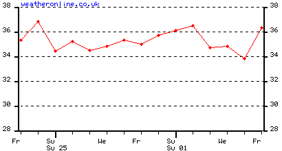
Posted 24th October 2015:
Absolutely un bearable Heat Wave in Mumbai...October Heat, Worst than May Heat !!
Last 10 days have seen an abnormal and Unseen Heat Wave of Mumbai ..
Mumbai : Heat and record Heat, Last 10 days days>>>
Scruz:(October)
24th 36.8c - 24.8c Colaba 33.7c - 27.3c
23rd 35.3c - 24.6c Colaba 33.9c - 28.2c**
22nd 36.4c- 23.6c Colaba 34.9c - 27.7c
21st 37.5c - 23.9c Colaba 36.2c - 27.2c
20th 37.1c - 24.2c Colaba 35.4c - 27.4c
19th 37.5c - 25.3c Colaba 35.8c - 27.8c
18th : 37.4c - 25.7c Colaba 33.5c - 28.0c
17th: 37.5c - 25.6c Colaba 36.1c - 27.6c
16th: 38.6c* - 22.4c Colaba 34.8c - 26.5c
15th : 37.2c - 25.4c Colaba 34.8c - 27.4c.
* Record All Time High for October ** Record Night High for October
The Heat in Mumbai...As it started increasing....Oct 9th-Oct 23rd
And the Humidity...
The above Normal details of the Last 30 days...the Red region seen last 10 days...
--------------------------------------------------------------------------------------------------------------------------------------------------------------------------------------------------------------------------------------------------
Mumbai : Heat and record Heat last 6 days >>>
Scruz: October
20th: 37.1c - 24.2c
19th 37.5c - 25.3c
18th : 37.4c - 25.7c
17th: 37.5c - 25.6c
16th: 38.6c* - 22.4c * Record All Time High for October
15th : 37.2c - 25.4c
Colaba: October
20th 35.4c - 27.4c
19th 35.8c - 27.8c
18th 33.5c - 28.0c** ** Record Night High for October
17th 36.1c - 27.6c
16th 34.8c - 26.5c
16th 34.8c - 26.5c
15th 34.8c - 27.4c.
Tuesday 20th October Morning... Mumbai:

Mumbai Water supplying Lakes Position as on 6th October 2015:
Total filled of all lakes 81%: 11,70,000 mltrs. (Full: 14.43 lmltrs).
At the supply rate applying 20% water cut as on today, we have water to last 365 days...upto 5th October 2016. At Full supply, if the cut is not applied, there is water for 310 days, that is upto 15th August 2016.
Monthly & Monsoon Performance depicted by Vagarians Displayed Below:
From Vagarian Abhijit Modak:


--------------------------------------------------------------------------------------------------------------------------------------------------------------------------------
Marathwada:
After a good spell of Bountiful rains from BB-6, Maharashtra is now in for an almost dry spell next 5 days. This is now beneficial for the farms and standing crops. We understand, tht the recent rains in Marathwada has resulted in almost all the small dams overflowing or to the brim. This has brought the ground water table higher, and the local wells have seen a ris eof 12-15 feet in their water levels. More rise expected in wells as the water percolates into the side bores. Even the standing crop has got enough soil moisture till harvest time. This late rainfall was more helpfull as it was accompanied by lightning. Remember, that when lightning flashes across the atmosphere, it momentarily "consumes" up most of the oxygen from the air, resulting in a temporary increase in Nitrogen in the air space. This Nitrogen dissolves in the falling rain, and as we all know, Nitrogen is a very useful fertiliser for crops.
Retreating thunder showers are likely in interior Maharashtra after next Monday 28th September.
Mumbai Lakes Position as on 20th September 2015:
Middle Vaitarna Overflows..Water Diverted to Modak Sagar
Lakes Full Level Todays Level Short Storage Total Rainfall
Modak Sagar 163.15 162.86 -0.29 1.27 1693
Tansa 128.63 127.56 -1.07 1.25 1635
Vihar 80.12 76.97 -3.15 0.12 1941
Tulshi 139.17 139.02 -0.15 0 .08 2208
Upper vaitarna 603.51 603.48 -0.03 1.23 1804
Bhatsa 142.07 133.13 -8.94 4.90 1874
Middle vaitarna 285.00 284.30 -0.70 1.90 1895 *
* On Friday 18th, Reached full level, so water was released into the Modak Sagar
Total Available 1075254 mltrs (10.75 mltrs)....@ 3200 (0.032)/day (with 20% cut), we have 335 days water storage as on 20th September...That is up to August 15th 2016.
Out of 7 lakes, 4 are less than 1 meter below overflow ,1 is less than 2 meters from over flow, 1 around 3 meters and main supply Lake Bhatsa is 9 meter below overflow mark.
If it rains like yesterday three dam will overflow overnight hopefully
Information compiled by Vagarian Jayesh Mehta.
If we see the Position of 15th September, we have a storage of 9,96,000 mltrs, and on 20th September we have 10,75, 000...a rise of around 80,000 million ltrs ! In 5 days, it has rained to supply Mumbai City 25 days of water !! Nature's Bounty ...Lets be Grateful and Respect Nature..
You Need Nature...Nature Does not Need You !!
----------------------------------------------------------------------------------
Mumbai Water supplying Lakes Position as on 19th September:
Total filled of all lakes 72%: 10,40,000 mltrs. (Full: 14.43lmltrs).
At the supply rate applying 20% water cut as on today, we have water to last 325 days...upto July 30th 2016.
Mumbai Water supplying Lakes Position as on 15th September:
Levels in % as full:
Bhatsa 71%, Vaitarna 66%, Modaksagar 84%, Tansa 83%, Vihar 43%, Tulshi 100%, Middle vaitarna 98%.
Total filled of all lakes 69%: 9,96,000 mltrs. (Full: 14.43lmltrs).
At the supply rate applying 20% water cut as on today, we have water to last 311 days...upto July 20th 2016.
Certainly not comfortable, as levels will fall drastically from April, and we have consider the timely arrival of next Monsoon.
None of the Lakes received rainfall in 24 hrs ended 8.30 am 15th September.
Mumbai has about 985 Mcum water storage in all it supplying lakes, that is about 68% full. At the rate of present supply, without cut,Mumbai has a storage of about 262 days, that is till about 20th May 2016.
With Water cut implemented, the water is now available for 301 days, that is till 30th June 2016
Mumbai Water Supplying Lakes Storage as on 25th August 2015 ..
Mumbai has about 935 Mcum water storage in all it supplying lakes, that is about 64% full. At the rate of present supply, Mumbai has a storage of about 250 days, that is about 25th April.
Mumbai Water Supplying Lakes Storage as on 13th August 2015 ..
Mumbai has about 898 Mcum water storage in all it supplying lakes, that is about 62% full. At the rate of present supply, Mumbai has a storage of about 240 days, that is about 15th April.
August Details of Mumbai Eastern Outer Townships and Botivali sent by Vagarians' Private Stations:
Puneet sends Konkan Rains 2015

Badlapur from Abhijit 2015:

Panvel from Junaid


---------------------------------------------------------------------------------------------------------

---------------------------------------------------------------------------------------
Article on Marathwada to be Printed in Lokmat Times of Monday 3rd August:
Weather Watch
A miserable month for Marathwada
It has been a miserable month for Marathwada, and is suffering from extreme scarcity.as far as the Monsoon rains are concerned. The deficit in the Marathwada region is -56%.
In statistical terms, out of the normal 336 mms normal rain required on an average for Marathwada, only 146 mms have been received.
..Aurangabad has seen only 14 mms this July. But this is not far, or negligible from the record low which was 11 mms in 1971.
Parbhani measured only 21 mms this year, of course this being the driest July on record (Previous low was 15 mms in 1971). Nanded has received 165 mms as on date, against a normal of around 410 mms.
Osmanabad saw just 18 mms in July, and the total from June being just 87 mms, while normally the total should be 325 mms.
This has resulted in a very poor water storage position. The major dam, Jayakwadi is only 6% full, Purna Yeldari ( Parbhani) is only 1 % full, Purna Siddheshwar (Parbhani), Manjra (Beed) and Majalgaon (Beed) are at 0%, Lower Terana (Osmanabad) is also 0%, Sina Kolegaon (Osmanabad) is also at 0%. Manar and Vishnupuri in Nanaded are at 4% and 14% respectively. Upper Penganga ( Nanded) is at 15%. The best of all reservoir seems to be Lower Dudhna (Nanded) which is still at 25% only.
So, on an average, all major and medium Dams and reservoirs are full only 7% in Marathwada.
Nagpur regions Dams and reservoirs are 36% full. All Maharashtra average for Dams and reservoirs are 38% full in Storage.
The standing crops in Aurangabad region now are in a precarious condition. The Jowhar, Maize, Moong and other crops have a standing capacity to survive for only 4/5 days without water, that is immediate rains. The small time earthen dams and rivulets are dry, and the wells are getting deeper in water levels.
The cotton crop may withstand another week, probably. Aurangabad region may see light showers next week, but in pockets, not widespread. Region may get around 5-10 mms.
The next week sees light to medium rains in Vidharbh. Akola District may see some meaningful increase in rains on Tuesday/Wednesday for a couple of days. The district may get around 15-20 mms per day Tuesday/Wednesday and Thursday.
For Mumbai SantaCruz, July 2015 was the 3rd driest July on record..This July (2015) saw 360 mms of rain, and the previous lowest was in the drought year 1971, when 385 mms was recorded, and all time lowest was in 2002 when only 103 mms was recorded in July..
Mumbai Lake Storage in Mcum as on 29th July:
Bhatsa 521 , vaitarna 164 ,Modak sagar 111, Tansa 80, Vihar 10 Tulsi 7, Middle Vaitarna 174.
Total Storage 1067.
Allowing 33% for leakages, wastage, evaporation etc, we have 711 Mcum remaining for distribution.
At 3.75 supply per day, Mumbai has 189 days supply. That is about 6 months supply.
Mumbai Lake Storage as on 23rd June:
Quantity in Mcum
Bhatsa 284 (942)
U.Vaitarna 72 (331)
Modak Sgr 67 (129)
Tansa 23 ( 145)
Vihar 8 ( 28)
Tulsi 5 ( 8)
M.Vaitrna 105 (195)
564 Mcum (1178)
Available 574 Mcum...Reserve 33% for leakages, Loss and evaporation etc = 376 Mcum
Require 3.7 Mcum/day, we have 101 days Storage.
Source WRD (Mah Govt). Compiled by Jayesh Mehta.
Mumbai Santa Cruz sees the wettest June ever with 1090 mms as on Wednesday evening. The previous record was 1037 mms in 1971.
However, Colaba is far from its record June rainfall of 1280 mms in 1985.

-----------------------------------------------------------------------------------------------------------
Mumbai Water Supplying Lake Levels
Last available levels as on 12th June
Bhatsa 942 258
U.Vaitarna 331 51
M.Vaitarna 195 194
Modak 129 52
Tansa 145 12
Vihar 28 1
Tulsi 8 2
1778 480 (27%)
Supply Rate at 3.7 MCUM to city, Mumbai has about 95 days supply, or lasting till 15th September 2015. This is at present supply rate.
25% deducted for Drawable levels, Wastage in transit etc......
Rains encircling Mumbai....11.25 pm IST Saturday 6th June 2015
Lightening in Mumbai...
11.25 pm IST
10.25 pm IST
Mumbai Lakes and Water Position as on 16th february 2015....
--------------------------------------------------------------------------------------------------------------------------------------------------------------------------------------------------------------------------------
------------------------------------------------------------------------------------
---------------------------------------------------
Mumbai Weather Summary...2014 (From Rohit Aroskar)
Took these Pics while flying over Matheran on Monday 15th December ....
Matheran is a Hill Station in the Indian state of Maharashtra. It is also the smallest hill station in India. It is located on the Western Ghats range at an elevation of around 800 m (2,625 feet) above sea level. It is located around 90 km from Mumbai, and 120 km from Pune. Matheran's proximity makes it a popular weekend getaway for urban residents. Matheran, which means "forest on the forehead" (of the mountains) is an eco-sensitive region, declared by the Ministry of Environment and Forest, Government of India. It is Asia's only auto mobile -free hill station
-------------------------------------------------------------------------------------------------------------------------------------------------------------------------------------------------------------------------------------------------------
Badlapur max & min temp presentation in graph for Nov 2014...by Abhijit Modak
Posted 1st December...
MumbaiBadlapur
Posted 19th October
Thunder Cells seen East of Mumbai as expected...
light rains in Dombivali and drizzles in Northern suburbs and Thane
Seen from South MumbaiThunder heads at Badlapur
Posted Friday 10th October 2014
Maharashtra Report on Monsoon
Monsoon Report For Maharashtra:
Overall, the Monsoon picture for the State is good, and normally Maharshtra should not see any water problems till next rainy season.
Map shows the overall rainfall for the season. State received almost normal rains, as only 38 out of 353 talukas received deficient rains.
It could also be mentioned, that as on date, 10th October, the South West Monsoon is still prevelent in most of the State barring the Northern regions. Sporadic thunder showers are seen and received in many regions of Marathwada till 9th October, while all regions of Madhya Maharashtra and interior Konkan regions are still getting fairly good thunder spells.
Marathwada:
Marathwada , at the end of September, was at -42%, having received only 399 mms against a normal of 683 mms.
Total live storage of all dams in Marathwada is ok at around 75%.
However, some sporadic thunder showers in the first week of October have added soil moisture and will help the rabi crop.
Jayakwadi, the main and huge source of water storage was better placed than in 2013 and 2012.
This year, the storage level is 45% of the full, better than 33% last year and much much better than only 3% in 2012 !
The level of Jayakwadi is critical and important, but is controlled by discharges from dams in Nashik, and sometimes outflows are allowed from Jayakwadi for downstream.
Crop wise, almost 40-45% of the Kharif crop has withered due to poor rains in Monsoon (Marathwda).
------------------------------------------------------------------------------------------------------------------------------------------------
-------------------------------------------------------------------------------------------------------------------------------------------------------------------------------------------------------------------------------------------------------------------------------------------------------------------------------------------------------------------
Thunderstorm Pics from South Mumbai...approximately 35-40 trees were uprooted in the 90 mins Storm....Pics by Salil, Mangesh and Abhijit
----------------------------------------------------------------------------------------------------------------------------------------
--------------------------------------------------------------------------------------------------------------------------------------------------------------------------------
Thunder Showers may start in a few days around Mumbai....Posted 16th Evening-
Posted September 6th
Mumbai: The 2 IMD stations of Mumbai have touched their normal rainfall figures in spite of severe "ups and downs'' in a roller coaster ride.
The Monsoon set in on June 16th over the city.
June was dry!. The driest EVER in Colaba , when this South Mumbai station received a meagre 5 mms of rain in the Month. Sanata Cruz was no better with only 87 mms in June. A very dry June !
After hitting the bottom, the roller coaster took an upward journey. A very wet July, with tremendous rains, and resulting in the wettest July EVER for Santa Cruz , with 1469 mms in the month....Now thats something.
But, it not over. August was going dry again. Save the recovery in the last 2 days of August, rains were minimal. But, the good rains in frst week of september pushed up the seasonal total to 2050 mms at Colaba and 2245 mms at SantaCruz. The normal seasonal toatl till end September required is 2053 mms for Colaba and 2232 mms for Cruz.
Lakes supplying water to Mumbai are also showing good levels.Most of them are nearly on the overflow mark, and I would expect all to overflow next week.
Water supply to the city could last for a year at current position and levels.
Mumbai will be partly cloudy with sunny spells on sunday> A few passing showers.
Monday will be partly cloudy with some showers in the evening. A few heavy showers in parts of city. Around 10-15 mms during the day.
Tuesday rains increase, with intermittent rain in the day. A few thunder showers will be very heavy post noon, leading to local flooding. Around 75 mms in the day.
--------------------------------------------------------------------------------------------------------------------------------------------------------------------------------------------------------------------------
Mumbai Colaba received 23 mms and Scruz 15 mms in 12 hrs from 08.30 am Monday 1st Sept
--------------------------------------------------------------------------------------------------------------------------------------------------------------------------------------------
Come Saturday Evening, and the forecasted Thunder storms came..
Heavy Storms reported by Junaid, Abhijit and Puneet from Eastern Outer Townships of Panvel, Badlapur and Dombivali.
Pic sent by Junaid and Abhijit.
Vineet and other vagarians tell of heavy showers in Pune.
Steady drizzle with Thunder here in South Mumbai since 6.00 pm IST
----------------------------------------------------------------------------------------------
Thursday Morning,21st August, Mumbai got a surprise thunder shower around early morning....A Vortex in the upper atmosphere near Mumbai caused a short but severe thunder shower in Mumbai. Lasting 2 hours overall on Thursday morning, the peak rainfall from 7 am to 8 am brought the major rainfall. Vagaries 38 mms, Colaba 33.6 mms and Scruz 29.6 mms.
Dadar recorded 96 mms, Worli 81 mms, Dharavi 55 mms.
Min remained high at 27c...and yesterday was odd with max at 27.8c, and min Wed morning was 27c.
 Dadar Mumbai, Thursday Morning (Courtesy Salil)
Posted Tuesday 19th Night:
Follow up of Monday afternoon's Forecast.....
Thunder Showers Activity from Nasik Southwards to Kolhapur as explained yesterday..
And , as mentioned, North winds meeting West winds..
Mumbai was very cloudy, but as expected, just 1 mms of rain at Scruz.
Pune , being in the Thunder activity zone, saw 23 mms till 5.30 pm Tuesday.
Delhi day soared to 37c Tuesday.
Posted Monday 18th Afternoon:
Next 2/3 Days:
1. A ridge gradually forming in the central Arabian Sea.
2. Direction of winds along West Coast of India will change to NW.
2(a). Mumbai gets very little rainfall of < 5mms per day from Monday through Thursday. Though sky can be cloudy, actual precipitation may be light showers in some parts.
3. In Madhya Mah, interaction of North winds with West winds could bring thunder showers popping up from Nasik Southwards till Kolhapur on Tuesday through Thursday (Pune falls in the zone).
Mumbai Eastern Outer Townships may get the stray Thunder Cell in the vicinty
4. Clockwise winds at 700 mb levels indicate the formation of an upper ridge in NW India from Monday. Through the week, the anti cyclone may bring almost clear skies in NW India and Delhi regions. We may see the days touching 40c in NCR or Haryana. Seeing some improvement from Saturday 23rd.
------------------------------------------------------------------------------------------------------------------------------------------------------------------------------------------------------------------------
-----------------------------------------------------
| - |
     
Super Diagram of Mumbai Region by Rohit
 
As on 29th July
  Mumbai Lakes levels as on 17th July ...Prepared by Jayesh Mehta The lakes are 90% empty as per the final total ...1.45 lmltrs storage today against full capacity of 14.5 lmltrs   
-------------------------------------------------------------------------------------------------------------------------------------------------------------------------------------------------------------------------------------------------------
 Mumbai Monsoon Status with Lakes As on 12th July 2014... Rainfall on Saturday 12th July was less than Friday and last few days: Colaba had 58 mms and Scruz 50 mms on Saturday. Total Rain from 1st June to 12th July: Colaba 741 mms ( 8.30 am) ....799 mms (8.30 pm) Scruz 709 mms ( 8.30 am)....760 mms ( 8.30 pm) Total Rainfall from 1st June till 12th July in Lakes: Modak 194 mms Tansa 167 mms Vihar 718 mms Tulshi 805 mms Bhatsa 306 mms Upper Vaitarna 192 mms Water Storage on Date: 92823 Mcum that is 35 days stock at 20% water cut... ------------------------------------------------------------------------------------------------------------------------------------------------------------------- Mumbai Monsoon Status with Lakes As on 10th July 2014...  Total Rainfall from 1st June to 10th July Night : Colaba 635 mms Santacruz 574 mms Vagaries 610 mms Total rainfall in lakes from 1 June to 10 July 2014 : Tulshi 533 mms Vihar 480 mms Bhatsa 166 mms Modak Sagar 146mms Vaitarna 134 mms Tansa 105 mms The Lake levels are very low and disappointing. As on 10th July, the total Lake Storage is 89619 Mcum. (624531 Mcum last year this date). If we take the normal requirment and supply to Mumbai, which is .03500 Mcum/day, we have aout 25 days supply, that is till 5th August. Now, with 20% cut, the city is supplied .02800 Mcum/day. With the cut effective , we have about 31 days storage, that is till 11th August. -------------------------------------------------------------------------------------------------------------------------------------------------------------------------------------------------------------------------------------------------------------------------------------------- Mumbai Water Supply Lakes Position as on 5th July 2014...Prepared by Jayesh Mehta
For Many Palces in Maharashtra, The Driest June Ever...Compiled by Abhijit It's official that Maharashtra regions, specially coastal Konkan, many towns/cities have broken all time record of lowest rainfall for June ! It is one of weakest onset of SWM over Konkan region ever..Because we see many cities previous all time low rainfall records Colaba saw 91.7 mms in 1947 Alibaug saw 147 mms in 1947 Ratnagiri saw 236 mms in 1952 Harnai saw 228 mms in 1966
And this current June 2014, saw new all time lowest rainfall record for all above cities this year and much less rain too than previous record !
Colaba 55.2 mms Alibaug 95 mms Ratnagiri 178.6 mms Harnai 182.7 mms Hoping that such Driest June never comes in future and current new all time lowest rainfall record should never get broken !!
RAINFALL BELOW FOR MUMBAI & SURROUNDING REGION WITH WATER SUPPLYING LAKE AREA RAINFALL ALSO INCLUDED FROM PERIOD OF 1 JUNE TO 30 JUNE 2014.
WE CAN SEE DEFICIT IS HUGE IN ABOVE TABLE, AS IT RANGING FROM -73% TO -94% OF JUNE AVERAGE !!
RAINFALL BELOW FOR SOME OF KONKAN REGION STATIONS FROM PERIOD OF 1 JUNE TO 30 JUNE 2014.
RAINFALL BELOW OF SOME STATIONS FROM MADHYA MAHA, MARATHAWADA & VIDARBHA REGIONS FROM PERIOD OF 1 JUNE TO 30 JUNE 2014.
------------------------------------------------------------------------------------------------------------------------------------------------------------------------------------------------------------------------------------------------------------------------ Mumbai Lakes Levels from Jayesh Mehta 13-Jun-14 LAKESCurrent Mcum Modak Sagar68 Tansa22 Vihar1 Tulsi3 Upper Vaitarna100 Bhatsa308 Middle Vaitarna0 Total Water @ Dam502 Usable Water As on13/06/2014>>>>377 Water Avaibale @ 3.4 Mcum per Day for date upto 02/10/2014 Water ResourceDepartment Maharashtra South Mumbai was fair enough in 2014 summers :
Sent and Compiled by Rohit Aroskar ...
March : 30.2 / 23.2 , April : 31.6 / 24.9 , May : 31.1 / 27.2
North Mumbai was comparatively warmer :

The humidity makes Mumbai summers muggy
LAST YEAR MONSOON RAINS- SCZ: 252 CMS , CLB : 243 CMS , EASTERN SUBURBS(mainland) :400 CMS + 19-May-14 |
|||||||||||||||||||||||||||||||||||||||||||||||||||||||||||||||||||||||||||||||||||||||||||||||||||||||||||||||||||||||||||||||||||||||||||||||||||||||||||||||||||||||||||||||||||||||||||||||||||||||||||||||||||||||||||||||||||||||||||||||||
| LAKES | Current | |||||||||||||||||||||||||||||||||||||||||||||||||||||||||||||||||||||||||||||||||||||||||||||||||||||||||||||||||||||||||||||||||||||||||||||||||||||||||||||||||||||||||||||||||||||||||||||||||||||||||||||||||||||||||||||||||||||||||||||||||
| Mcum | ||||||||||||||||||||||||||||||||||||||||||||||||||||||||||||||||||||||||||||||||||||||||||||||||||||||||||||||||||||||||||||||||||||||||||||||||||||||||||||||||||||||||||||||||||||||||||||||||||||||||||||||||||||||||||||||||||||||||||||||||||
| Modak Sagar | 63 | |||||||||||||||||||||||||||||||||||||||||||||||||||||||||||||||||||||||||||||||||||||||||||||||||||||||||||||||||||||||||||||||||||||||||||||||||||||||||||||||||||||||||||||||||||||||||||||||||||||||||||||||||||||||||||||||||||||||||||||||||
| Tansa | 35 | |||||||||||||||||||||||||||||||||||||||||||||||||||||||||||||||||||||||||||||||||||||||||||||||||||||||||||||||||||||||||||||||||||||||||||||||||||||||||||||||||||||||||||||||||||||||||||||||||||||||||||||||||||||||||||||||||||||||||||||||||
| Vihar | 4 | |||||||||||||||||||||||||||||||||||||||||||||||||||||||||||||||||||||||||||||||||||||||||||||||||||||||||||||||||||||||||||||||||||||||||||||||||||||||||||||||||||||||||||||||||||||||||||||||||||||||||||||||||||||||||||||||||||||||||||||||||
| Tulsi | 3 | |||||||||||||||||||||||||||||||||||||||||||||||||||||||||||||||||||||||||||||||||||||||||||||||||||||||||||||||||||||||||||||||||||||||||||||||||||||||||||||||||||||||||||||||||||||||||||||||||||||||||||||||||||||||||||||||||||||||||||||||||
| Upper Vaitarna | 158 | |||||||||||||||||||||||||||||||||||||||||||||||||||||||||||||||||||||||||||||||||||||||||||||||||||||||||||||||||||||||||||||||||||||||||||||||||||||||||||||||||||||||||||||||||||||||||||||||||||||||||||||||||||||||||||||||||||||||||||||||||
| Bhatsa | 374 | |||||||||||||||||||||||||||||||||||||||||||||||||||||||||||||||||||||||||||||||||||||||||||||||||||||||||||||||||||||||||||||||||||||||||||||||||||||||||||||||||||||||||||||||||||||||||||||||||||||||||||||||||||||||||||||||||||||||||||||||||
| Middle Vaitarna | 0 | |||||||||||||||||||||||||||||||||||||||||||||||||||||||||||||||||||||||||||||||||||||||||||||||||||||||||||||||||||||||||||||||||||||||||||||||||||||||||||||||||||||||||||||||||||||||||||||||||||||||||||||||||||||||||||||||||||||||||||||||||
| 637 | 478 | |||||||||||||||||||||||||||||||||||||||||||||||||||||||||||||||||||||||||||||||||||||||||||||||||||||||||||||||||||||||||||||||||||||||||||||||||||||||||||||||||||||||||||||||||||||||||||||||||||||||||||||||||||||||||||||||||||||||||||||||||
| Usable Water | ||||||||||||||||||||||||||||||||||||||||||||||||||||||||||||||||||||||||||||||||||||||||||||||||||||||||||||||||||||||||||||||||||||||||||||||||||||||||||||||||||||||||||||||||||||||||||||||||||||||||||||||||||||||||||||||||||||||||||||||||||
| As on | ||||||||||||||||||||||||||||||||||||||||||||||||||||||||||||||||||||||||||||||||||||||||||||||||||||||||||||||||||||||||||||||||||||||||||||||||||||||||||||||||||||||||||||||||||||||||||||||||||||||||||||||||||||||||||||||||||||||||||||||||||
| 19-May-14 | ||||||||||||||||||||||||||||||||||||||||||||||||||||||||||||||||||||||||||||||||||||||||||||||||||||||||||||||||||||||||||||||||||||||||||||||||||||||||||||||||||||||||||||||||||||||||||||||||||||||||||||||||||||||||||||||||||||||||||||||||||
| Usable water | ||||||||||||||||||||||||||||||||||||||||||||||||||||||||||||||||||||||||||||||||||||||||||||||||||||||||||||||||||||||||||||||||||||||||||||||||||||||||||||||||||||||||||||||||||||||||||||||||||||||||||||||||||||||||||||||||||||||||||||||||||
| available up to | ||||||||||||||||||||||||||||||||||||||||||||||||||||||||||||||||||||||||||||||||||||||||||||||||||||||||||||||||||||||||||||||||||||||||||||||||||||||||||||||||||||||||||||||||||||||||||||||||||||||||||||||||||||||||||||||||||||||||||||||||||
| date with Approx | ||||||||||||||||||||||||||||||||||||||||||||||||||||||||||||||||||||||||||||||||||||||||||||||||||||||||||||||||||||||||||||||||||||||||||||||||||||||||||||||||||||||||||||||||||||||||||||||||||||||||||||||||||||||||||||||||||||||||||||||||||
| 3.4 Mcum per Day | 09/10/2014 | |||||||||||||||||||||||||||||||||||||||||||||||||||||||||||||||||||||||||||||||||||||||||||||||||||||||||||||||||||||||||||||||||||||||||||||||||||||||||||||||||||||||||||||||||||||||||||||||||||||||||||||||||||||||||||||||||||||||||||||||||
| use | ||||||||||||||||||||||||||||||||||||||||||||||||||||||||||||||||||||||||||||||||||||||||||||||||||||||||||||||||||||||||||||||||||||||||||||||||||||||||||||||||||||||||||||||||||||||||||||||||||||||||||||||||||||||||||||||||||||||||||||||||||
| Water Resource | Department | Maharashtra | ||||||||||||||||||||||||||||||||||||||||||||||||||||||||||||||||||||||||||||||||||||||||||||||||||||||||||||||||||||||||||||||||||||||||||||||||||||||||||||||||||||||||||||||||||||||||||||||||||||||||||||||||||||||||||||||||||||||||||||||||
Posted Monday Evening: As forecasted, the maximum Temperature jumped to 35.8c at Scruz on Monday.....
Mumbai City may get the Pre Monsoon showers ( Thunder) from 1st/2nd June onwards
Posted Sunday ( 18th May) Evening:
Mumbai: Next 4 days....19th May - 22nd May.
Partly Cloudy days. Seeing some towering Thunder heads in the East on Monday 19th. Some drifting of alto cumulus in the evening from the East. Nights will be partly cloudy and stuffy, humid and sweaty. North/North-West winds will be sharp in the evening at around 25-30 kmph.
Hotter next 2 days in the week ! As the humidity increases, with passing day,warmer real feel temperatures will make the day sweaty.
Temperatures will be between 36c and 28c on Monday and Tuesday. But, humidity more and temperature less on Wednesday and Thursday..at 34c and 28/29c...so harsher real feel !
On Sunday evening, Eastern Outer townships got a dust storm with thunder. Matheran received rains (about 8 mms as per unofficial report). Intense rains seen around Matheran and rain patch in the North...
Eastern Outer Townships:
Possibly will see some Cumulus developments on Monday 19th, and with cloudy skies, night temperatures will show a rise as they get stuffy.
Tuesday, the outer towns will be hot, and with the temperature at 37/38c and humidity at 65%, its going to be un comfortable. Nights warming up to 27/28c.
Temperatures shift down 2 degrees from Wednesday.
Pune: Partly cloudy. Tuesday 20th some Cumulus developments in some parts. Otherwise, days will be around 40c, and nights rising to almost 25/26c.
------------------------------------------------------------------------------------------------------------------------------------------------------------------------------------------------------------------------------------------------------------------------
Posted Saturday Morning:
Mumbai, Saturday 26th, Sunday 27th and Monday 28th will not be as comfortable as the temperature readings will show.
The day's Max on these 3 days will not go over 34c. Ok, good !. But the high humidity that will sweat the city will be around 70-80%. This will make a Real Feel temperature of around 39/40c in Mumbai.
W/NW winds will bring in cooler sea breeze, and a good lot of humidity with it. In fact, we have WNW winds upto the 850 level over Mumbai, and a ridge at the 700 level. This will surely block the humidity and warmth on the ground level.
So, as a result, the nights will be around 27c...warm and stuffy !
Clear skies.
-------------------------------------------------------------------------------------------------------------------------------------------------------------------------------------------------
| 19-May-14 | ||
| LAKES | Current | |
| Mcum | ||
| Modak Sagar | 63 | |
| Tansa | 35 | |
| Vihar | 4 | |
| Tulsi | 3 | |
| Upper Vaitarna | 158 | |
| Bhatsa | 374 | |
| Middle Vaitarna | 0 | |
| 637 | 478 | |
| Usable Water | ||
| As on | ||
| 19-May-14 | ||
| Usable water | ||
| available up to | ||
| date with Approx | ||
| 3.4 Mcum per Day | 09/10/2014 | |
| use | ||
| Water Resource | Department | Maharashtra |
--------------------------------------------------------------------------------------------------------------------------------------------
Posted Thursday 15th Night:
Mumbai finally showing signs of reducing temperatures...Maximum on Thursday was 36 5c at Scruz ( reduced by 2.5c from Tuesday) and it was 33.4c at Colaba, educed by 3c.
As mentioned earlier, we can expect the mercury to reach 35c by Friday. Expect NW winds to bring in sea breeze and bring the temperatures down...and the humidity up !
The minimums are also as per our estimate, 26.4c at Colaba and 25.0c at Scruz.
Posted 24th April:
And Mumbai Het continues for the 4th day running....
Query from Abhijit: " Sir : Why so much of heating in just 30 -40kms inland to ARB sea this year ? Int Maha areas like Nashik, Pune Aurangabad yet to see their first 40c temp ! And we in interior coastal Konkan had 40c+ for 5 times ! 4 of them in Apr itself..?"
Well, this wind chart explains it all...
..
The wind Chart..shows NE winds in the Northern Coastal (West)
means bringing very dry NE winds and pushing away the sea breeze and humidity...there is a ridge along coast at upper level that is preventing hot air from rising, and cool sea breeze not able to enter coast, so even the konkan interior heats up..ridge always stubborn and hot in this month...
That is why even the nights are warm, Vagaries recorded a min of 28.4c on Wednesday morning and 28.0c on Thursday.
Surat was 41c and many North Konkan Cities like Thane, Kalyan and Badlapur were over 40c.
------------------------------------------------------------------------------------------------------------------------------
Posted 22nd April 2014:
Northern Suburbs of Mumbai received light showers on Monday , 21st April night. Parts of Ghatkopar, Goregaon, Sion and Vikhroli got medium showers with tunder. Thane, ad surroundings too received good showers in the night.
Panvel and Badlapur reions received light drizzles late at night. Navi Mumbai received heavy showers with thunder.
meanwhile, Santacruz soared to 39c on Monday, highest after 2009 in April when it had touched 40.6c on th 2nd of the Month. The highest ever for April is 42.2c, on 14th April 1952. The lowest minimum at Sanata Cruz ever for April was in 1968 when it dropped to 16.9c.
Colaba was 36c. The highest in April ever for Colaba is 40.6c, which was on 19th in 1955. The lowest minimum for Colaba ever was 20c in 1905.
Vagaries recorded 38.1c on Monday.
Thundery cloud developments around the ghats on Wednesday, and temperatures crossing 36c in Mumbai. Partly cloudy for Mumbai.
"Maharashtra Special" mentioned on Thursday for Sunday and Monday, now decreases. Rains decrease in intensity. ------------------------------------------------------------------------------------------------------------------------------------------------
Posted 2nd December 2013
Regions around Eastern Mumbai townships also received some showers (Karjat)...Showers will recede to South on Tuesday, and vanish by Wednesday.
The stuffy weather in Mumbai will ease from Wednesday night (Thursday morning) as we see a fall of 3/4c on Thursday morning..
Pune and some regions around Pune received Thunder showers on Monday evening.
Aurangabad got a heavy downpour of 40 mms between 10 pm and 11.30 pm IST on Monday night. Temperature dropped from 25.5c to 19c i an hour.
Low stratus and cumulus clouds were observed at a height of 300 metres only.
-----------------------------------------------------------------------------------------------------------------------------
Posted on 4th November @ 11 pm IST
Eastern Outer townships of Mumbai received light drizzles on Monday Night.
Mumbai will be warm on Tuesday at 35c, but dropping a couple of degrees from Wednesday. Winds change to NE from Wednesday.
Partly cloudy on Wednesday and Thursday, with Thunder clouds in the East.
Chances of thundery development and light shower in Outer townships (Eastern) on Wednesday and Thursday.
Cooler temperatures from Friday, seeing a drop in the night temperatures below 20c. Outer townships see a drop to 18c after Friday.
Posted on 1st November @ 11 pm IST
Mumbai:
Mumbai is the usual. Days are in the predicted 33/34c range. But, things could be a little more warmer on Divali day. East winds are going to keep the days warm at 34c, but maybe at 35/36c on Sunday. Nights will show some variation by dropping to 22/23c.
Mumbai may see some light clouding on Monday, raising the night temperature.
Pune remains partly cloudy for Divali, with days around 31c and nights at 17/18c.
-------------------------------------------------------------------------------------------------------------------------------------Posted 5th October 2013
Some not usually seen Arcus clouds over Mumbai (South)..saw these on Saturday evening and clicked on my cell....see 3rd Pic...actually they are forming on the land...just after the coastlne


Mumbai Lake Levels and Details of Lake Rains from JayeshMehta. ..28th September 2013
Mumbai Wednesday Night Storm Video..excuse the poor quality...Taken at Mahalaxmi..between 12.30 am and 1 am..when 23 mms were recorded...see here
Rainfall around Mumbai ending 8.30 am today(16-09-2013) sent by Abhijit Modak:
Santacruz 43.9mm
Colaba 17.4mm
Vagaries 26.0mm(till 12.15am available)
Vihar(Mumbai) 76.0mm
Tulshi(Mumbai) 59.0mm
Alibaugh 29.0mm
Uran 22.0mm
Panvel 59.2mm
Karjat 52.5mm
Khalapur 41.0mm
Vasai 24.0mm
Thane 68.5mm
Bhivandi 57.0mm
Murbad 63.0mm
Shahapur 21.8mm
Kalyan 18.0mm
Ulhasnagar 28.0mm
Ambernath 15.3mm
Barvi(Badlapur) 43.0mm
More From Mumbai City:
Chembur 137 mms, Goregaon 122 mms, Kurla 115 mms, Vikhroli 98 mms, Bhandup 61 mms, Kandivali 60 mms, Scruz (IMD) and Worli 44 mms, Deonar 40 mms, Nana Chowk 30 mms.Vagaries (Mahalaxmi) and Dadar 28 mms, Colaba (IMD) 17 mms.
Badlapur recorded 186.4mm rain ending 8.30am today. In that 100mm had recorded in just 1hr period between 5.30pm to 6.30pm yesterday evening..
Figures of Konkan August Rainfall from Abhijit:
Some Konkan coastal places lowest rainfall recorded for Aug 2013 :
Alibaug 161mm (66% deficit)
Murud 177mm (75% deficit)
Colaba 234mm (51% deficit )
Vasai 245mm (42% deficit)
Santacruz 255mm (52 % deficit)
Palghar 286mm (32% deficit)
Shriwardhan 296mm (60% deficit)
Aug 2013 has became lowest rainfall month in last 10 year period for Mumbai(SCZ).
Previous low rainfall was 290mm in Aug 2009.
And Information from Puneet Bangera
Jayeshbhai sends Last years Vagaries Lake Levels comparison (as put on vagaries) with today's Level
Thane District Rainfall Diagram from Rohit Aroskar and Table from Puneet:
Rainfall around Mumbai ending 8.30 am today(31-07-2013)..By Abhijit Modak
Colaba 9.0mm
Santacruz 31.0mm
Vagaries 26.0mm
Vihar(Mumbai) 40.0mm
Tulshi(Mumbai) 40.0mm
Alibaugh 7.0mm
Uran 20.0mm
Panvel 21.6mm
Karjat 77.7mm
Khalapur 25.0mm
Vasai 12.0mm
Thane 29.2mm
Bhivandi 35.0mm
Murbad 37.0mm
Shahapur 44.2mm
Kalyan 38.0mm
Ulhasnagar 46.2mm
Ambernath 40.8mm
Barvi(Badlapur) 77.0mm
Prepared by Jayeshbhai Mehta
Rainfall around Mumbai ending 8.30 am today(25-07-2013)
Colaba 35.3mm
Santacruz 28.2mm
Vagaries 51.0mm
Alibaugh 26.1mm
Uran 67.0mm
Panvel 84.0mm
Karjat 152.9mm
Khalapur 92.0mm
Vasai 21.0mm
Thane 35.0mm
Bhivandi 57.0mm
Murbad 43.0mm
Shahapur 18.2mm
Kalyan 50.0mm
Ulhasnagar 33.4mm
Ambernath 54.2mm
Colaba 35.3mm
Santacruz 28.2mm
Vagaries 51.0mm
Alibaugh 26.1mm
Uran 67.0mm
Panvel 84.0mm
Karjat 152.9mm
Khalapur 92.0mm
Vasai 21.0mm
Thane 35.0mm
Bhivandi 57.0mm
Murbad 43.0mm
Shahapur 18.2mm
Kalyan 50.0mm
Ulhasnagar 33.4mm
Ambernath 54.2mm
Posted by Abhijit
Mumbai Region Rain Compilation by Rohit Aroskar

Lake Levels comparison with Last year and Today's Level..Compiled by Jayesh Mehta
Rainfall around Mumbai ending 8.30 am today(20-07-2013)...From Abhijit Modak
Colaba 71.4mm
Santacruz 78.9mm
Vagaries 56.4mm
Vihar(Mumbai) 62.0mm
Tulshi(Mumbai) 61.0mm
Alibaugh 93.1mm
Uran 105.0mm
Panvel 97.2mm
Karjat 114.5mm
Khalapur 88.0mm
Vasai 21.0mm
Thane 57.2mm
Bhivandi 35.0mm
Murbad 30.0mm
Kalyan 31.0mm
Ulhasnagar 52.6mm
Ambernath 35.1mm
Barvi(Badlapur) 67.0mm
Rainfall around Mumbai ending 8.30 am today(19-07-2013)...From Abhijit Modak
Colaba 31.2mm
Santacruz 17.8mm
Vihar(Mumbai) 22.0mm
Tulshi(Mumbai) 25.0mm
Alibaugh 11.0mm
Uran 90.0mm
Panvel 45.0mm
Karjat 82.7mm
Khalapur 115.0mm
Vasai 2.0mm
Thane 22.4mm
Bhivandi 40.0mm
Murbad 60.0mm
Kalyan 36.0mm
Ulhasnagar 31.0mm
Ambernath 24.4mm
Barvi(Badlapur) 46.0mm
Mumbai Water Supply Lake Levels:
Sent and compiled by Jayesh Mehta


Table prepared by Jayesh Mehta for vagaries

Saturday 13th July 2013:
On Friday, Mumbai was flooded, traffic snarled and trains were late...was it heavy rains,or mismanagement ?
The rain amounts put up below, for Friday's rain are heavy, no doubt, but hasn't Mumbai seen much more than this before ? Even double this amount is normally expected in Mumbai in June and July...anyway..
Rainfall from Friday morning to Saturday morning:
Dadar and Wadala 115 mms, Chembur 111 mms, Borivali 107 mms, Worli 104 mms, Dahisar 90 mmms, D Ward (Nana Chowk) 65 mms, Vikholi 59 mms.
IMD Colaba 49 mms, Sanat Cruz 108 mms and Vagaries 87 mms.
The average for Western Suburbs was 83 mms, Eastern Suburbs was 86 mms and Island City was 85 mms.
(The average rain amount put up by vagaries for the period was upto 55 mms (For Mumbai City, so overshooting by 30 mms).
The outer townshps rainfall will be put up by noon (by Abhijit). But from figures received for Northern Townships, Vasai recieved 133 mms till 8 pm Friday.
Lake levels and rain amounts will be put up on this page as soon as they are confirmed..anyway, why are we so excited about Tulshi overflowing. Water supply to Mumbai is 3500 mltrs/day, and only 40 mltrs is taken from Tulshi. Its like adding a bottle of mineral water in your overhead water tank...as some say "the mineral water bottle has overflowed."
x-------------------------x--------------------------x-------------------x
Rainfall around Mumbai ending 8.30 am today, Friday, 12th...posted by Abhijit Modak
Colaba 30.2mm
Santacruz 35.4mm
Vagaries 46.5mm
Vihar(Mumbai) 52.0mm
Tulshi(Mumbai) 64.0mm
Alibaugh 64.4mm
Uran 87mm
Panvel 71.4mm
Karjat 170.0mm
Vasai 87.0mm
Thane 68.0mm
Kalyan 93.0mm
Ulhasnagar 108.8mm
Ambernath 97.6mm
Barvi(Badlapur) 157.0mm
State Capitals and Mumbai June Rainfall Details Provided for Vagaries by Rohit Aroskar


Mumbai region - Top 11 rain stations June 2013(rain in cms) .. (all 11 century makers)..
Mumbai Tulshi 187 Ulhasnagar 121
Thane 119
Mumbai Vihar 117
Karjat 117
Panvel 115
Khalapur 113
Kalyan 109
Ambarnath 103
Mumbai SCZ 103
Mumbai Water Supply Lake Levels as on 18th June:Available Storage in Mcum, With % full in brackets):
Modak Sagar 34 (26%)
Tansa 61 (42%)
Tulsi 4 (50%)
Vihar 9 (32%)
Bhatsa 351 (37%)
Vaitarna 101 (31%)
Total Available Storage @ 80% = 450 Mcum @34/day = 130 days Stock.
Marathwada Dams at 226 Mcum, only 4% of total Stock. Jayakwadi Level = 0.
Total Reservoirs and Dams of Maharashtra: 18% full
Source : Water Resources, Govt. of Maharashtra.
x-------------------------------x--------------------------------x-------------------------------x
Rainfall Figures in mms for Raigadh and Thane District as on Monday Morning 17 th june
Alibaug 81
Panvel 256
Karjat 231.5
Khalapur 199
Uran 260
Sudhagad 58
Pen 188.1
Mahad 93.5
Mangaon 35.2
Roha 131
Poladpur 125
Murud 61
Shriwardhan 21
Mahasala 36
Tala 87
Tulshi lake 280
Vihar lake 169
Thane 145.6
Kalyan 127
Murbad 165
Bhivandi 115
Vasai 78
Wada 83
Shahapur 93
Dahanu 5.6
Palghar 56.2
Javhar 106
Mokhada 59.8
Talasari 23
Ulhasnagar 156.4
Ambernath 185.4
Vikramgadh 63
x---------------------x-----------------------------------------x-------------------------------x
Brief Saturday, 15th June Report as on 5.30 pm for Mah:
Cold day in Vid with days below normal by 11-12c. Coldest day at yeotmal at 24c, which is 12c below normal,and 36 mms rainfall, Amraoti at 25.2c was 11.7c below normal and Wardha with 70 mms rain was 25.8c, below by 11.1
Aurangabad was 25.4c (Max) and 8c below normal.
Mahableshwar recieved 72 mms and day's high was 18.7c (3c below normal).Jalgaon received 14 mms.
Ratnagiri managed 56 mms and while vagaries recieved 24 mms, Scruz and Colaba managed 10 mms each. (Vagaries has now gauged up 35 mms till 7 pm. Raining at time of report).
Lakes Levels supplying Water to Mumbai City as on 14th June:
Total Full Capacity Storage @ 80% 1343 Mcum...and Total available on date @ 80%: 350 Mcum.
Storage for 70 days available at full consumption without cut (Taken at 5 Mcum/Day).
Lake Wise % Storage available: Bhatsa 31%, Vaitarna 30%, Modak Sagar 13%, Tansa 25%, Vihar 21% and Tulsi 38%.
(From Irrigation Dept, Water Rescoces, Govt of Mah).
x------------------------------x------------------------------------------x---------------------------------------------x
Posted on Sunday @ 8.10 pm IST
Light rains from South Mumbai ...Dombivai and Panvel ...Monday's forecast happens on Sunday !
Pic sent by Abhijit from Badlapur today evening (Sunday)..super shot !


Posted on 31st Night...
Mumbai Water Supplying Lakes Position as on end of May....(from Mah Govt Water dept)
Current Storage : 505 Mcum.
Full Storage: 1700 Mcum (usable taken @ 80%)
Available Water: @ 80%: 400 Mcum...or 105 days @ current rate /Day.
Saturday 1st June/Sunday 2nd June: Partly cloudy and warm. Temp range 34/35c - 28/29c. Monday 3rd June: Partly cloudy with light drizzle in some parts. Thundery development in East of city..
..Temp 35 - 29c.
.
Tuesday 4th June: Light drizzle in some parts early morning or night.
Cloudy with towering clouds by evening in Eastern skies. Lightning seen and rain spell in outer regions and vicinity.
Wednesday 5th June.: Partly cloudy day, getting overcast by afternoon. Thundery developments by eveining, with showers in some parts.x--------------------------------------x--------------------------------------x-------------------------------------x
Mumbai Outlook till Sunday, 26th May:;Posted on 21st May Night.
Going on schedule from last Mumbai report of 19th,
the developments seem to be on stream.
Vagaries had calculated the formation of an off shore trough
along the West coast end of May.
The formation of a trough seems possible, with the NW winds
(High pressure effect) relenting to some extent due to organised cross SW winds
in the Arabian Sea and Somali current showing the effective SST. And with the
seasonal low possibly deepening to 994 mb this weekend, creating a good
gradient, what happens is given below:v
Wednesday 22nd /Thursday 23rd : 34c – 28c: Periods of clouds, with high
clouds of last 2 days relenting back to low clouds. Morning will be more dense.
Winds will be SW and real feel will be
37c in the day.Friday 24th: 35c – 29c: Partly cloudy, low cumulus clouds
gathering by evening..Days will be windy with SW winds and real feel factor
will be 37/38c.
Saturday 25th: Getting overcast by evening.
Thunder clouds will be seen developing by noon, and towering over the eastern
sky.
Meaning overcast with thunder heads for the outer townships,
possibly showers in some parts or vicinity.Sunday 26th: Cloudy morning getting overcast.
Thunder heads with towering cumulus forming in the east. By evening, the eastern horizon can get
overcast as the thunder showers drift towards city. Some parts can get showers with
lightning.
Outer townships will get thunder showers on Sunday afternoon/evening.
x---------------------------------------------x-----------------------------------------x---------------------------------x
May Weather of Mumbai Weather and Outlook for the Month:..Posted on 19th May 2013
(This is going to be a pleasant reading for our up country and North India fans...so, Mumbaites, do not grumble).
SCZ 33.4 - 24.9c and Clb 34.1 - 27.1...The average Temperature for Mumbai this May as on date.
This is the current
temperature range experienced in Mumbai. And I would say its around normal for
this time.
A humidity ranging
between 60% and 80%, has been the trend in the city for the last 10 days now.
For Mumbai..May 2013 is slightly
below normal. With light and under developed cumulus clouds and a W/NW wind
keeping the evenings just about manageable.
In fact, the weather
last 30 days Mid April through Mid May has been just
below normal, in
fact a bit below normal during May.
Diagram put shows a
below normal by 042c.


There has been no
rainfall yet from October 24th, 2011 thru May 20th 2012
in Mumbai.
That means straight
209 days (till 21st May 2012) without a drop of rain recorded !!
Last Year, up to
June 5th 2012 , Mumbai had 223 straight days without recording any rain !
I have no record for
the number of straight days without rain for Mumbai. If readers have any
information on this, please put it up on Vagaries..would be very interesting.
In previous years
the city has had many April/Mays without a single mm of rain. And it has no
bearing on the SWM rains later.
The wettest May, as
far as my records show, has been in 1918, when the city (Colaba) was drenched
with 279 mms. By coincidence, 1918 was a drought year in India, with one of the
lowest average rainfall on all India basis, 65 cms, against a normal of 89cms.
That is -27%. Absolutely a severe drought year.
The wettest May at
S'Cruz was in the year 2000, with 388 mms of rain.
Mumbai's (Colaba)
last 5 years' May rainfall has been: 2012=2012 0 mm, 2011=1 mm, 2010=0 mm,
2009=2 mms, 2008= 0 mms, 2007=1 mm, 2006=135 mms.
Outlook for May:
May 20th -25th:
Partly cloudy skies, specially in the mornings. Temperatures going in the 33c -
27c range. Humidity in the 65%-80% band.
May 26th -29th:
Expecting some increasing cloudiness after the 25th, indicating a rise in the
night temperatures. Morning clouds will be thicker, Cumulus clouds will be seen
towering late afternoon. Temperature range will be 34/35c-28c. Humidity will be
in the 70%-85% band.
May 29thst-1st June:
Thunder Heads will start to show up in the East. Some tending to drift and
precipitate over parts of Mumbai City.
For Mumbai, I would
like to maintain estimate of monsoon arrival dates, June 8th/9th.
Much awaited regular
Pre- Monsoon evening thundershowers could cool the city from around 30th May.
Regular Monsoon set
could be around the 8th/9th of June. Expecting initial commencement to be
sluggish.
However, pre-monsoon
thundershowers would also commence in the outer townships,
Lonavala/Pune/Khandala/Matheran hills by the 28th of this month.
Expecting
Mahableshwar to get its first pre monsoon showers by the 27th of May.
Quantum forecast for
the Mumbai City for June will be 675-725 mms.
If need be,
situation could go in for some revision changes, depending on the developments.
Mumbai Lakes Water
Storage as on 13th May 2013: 564 Mcum (Approx=32% of capacity) and approx =4.2
months storage).
This is the synoptic
situation as on today.
x----------------------------------x---------------------------------x------------------------x---------------------------x---------------------x-------------------------------x-----
Konkan Summer Analysis from Rohit...
Konkan and Goa subdivision till now :
This sunny subdivision has received the least rainfall amongst all the met subdivisions of India from 1st Jan -15th May 2013.The northern 2/3rd of this subdivision has hardly received any rainfall (0mms at most stations)from the start of the year (this is almost normal)..
This is the subdivision which gets 95+% of its annual rainfall from SW monsoon(291.4 cms) and ranks 2nd amongst the met sub-divisions which receive highest SW monsoon rain ..

Mumbai:
Monday/Tuesday: Sunny and hot, with High humidity making it sweaty and uncomfortable. Temperature range (Scruz) 35c - 25c. Real feel will be 40c. Colaba minimum will be 27c.
May Day, Wednesday: Sticky and sunny. Winds veering westwards increases the humidity and real feel will be 42c on a day's high of 36c. Low at Scruz will rise to 26c..
 Outer townships:
 Monday/Tuesday: Sunny and hot. Blazing sunshine will shoot the mercury to 39c, and nights too will be warm at 23/24c.
May Day, Wednesday: Strong W/SW winds will bring in humidity, and make it very hot at 39/40c. Warm temperatures till late evening.
Pune:
Monday/Tuesday:Very Hot and Sunny. Day temperatures rising to 41c and nights at 23/24c.
May Day Wednesday: Hot and still rising to 41/42c. Precautions against heatstroke necessary.

Nagpur: Very Hot ! Expected to touch 45c/46c next 2 days. May Day will be extremely hot at around 45c-46c. Nights will be uncomfortably high at 28/29c...
x---------------------------x-----------------------------x-----------------------------x
Sunset from S.Mumbai on Wednesday 13th March..


Posted on 9th March 2013:
As Maharashtra is facing drought and acute water shortage, Vagaries brings the latest water levels in various reservoirs in the State in % as Full and Last years level on same date:
Konkan Region reservoirs: 59% full (Last year at this time: 53%)
Marathwada: 11% and (Last Year 28%)
Nasik District 28% (34%)
Pune district 37% (44%)
General Other Reservoirs: 56% (54%)
All Maharashtra Average: 35% (40%)
Mumbai Supply Water Lakes levels are at 5.60 lmltrs (5.36 lmltrs). Supply can last for another 150 days taking the minimum drawable level into consideration.
x-------------------------------x------------------------------x-------------------------------------x------------------------x
Posted on 3rd March 2013..@ 6 pm...
Konkan (including Mumbai) and South Coastal Gujarat heats up and temperatures are nearly touching 40c in March first week.
Is that something unusual ? I have started hearing and "feeling" the GW bug around me. Yes. "Its never been soooo hot in Mumbai this early" to "its surely GW and If Mumbai is 38/39c now, what will happen in April and lets just not discuss May"...and so on....
But whats so unusual about this ? Nothing ! In the last 10 years, Mumbai has crossed 38c earlier 7 times (out of 10). The highest ever at Colaba of 41.6c was in March 2011 and highest ever in Santa Cruz of 42.2c was in April 1952.
The first 40c anywhere in India for the year 1981 was in Mumbai on 3rd March and again Mumbai was the first to touch 40c in 2007, again on 16th March. See Vagaries Extreme Blog)
Other places along the west coast too have similar highs in March. Ratnagiri, highest ever for March was in 2011 at 39.6c. Previously also in 1922, it had touched 38.9c in March. Panaji touched 39c in March (12th) 1979.Dahanu too, is famous for its 40.5c touched on 30th March 1982.
And Surat and Bharuch have got a 44c record for March(1973 and 1959).
So, if at all i have to accept the GW theory, then i might say the GW bug has been amonst us since the last 60 years....and consequently nothing new and untoward for us to worry about now....
A change from the winter routine pattern causes this untoward and high rise heating specially along the west coast.
The absence of a WD, and the emrgence of NW winds in the extreme North of the Sub continent plains, causes and gives rise to a High pressure area at Sea level and upto 850 mb, somewhere in central Rajasthan, stretchig SE into North MP. A prominent ridge also gets established along the west coast from Goa till the high pressure. See here
Thus, we see gush of NW winds at sea level North of Delhi, and turning clock wise to take a clean Easterly direction thru Maharashtra and flowing out into the sea thru the Maharashtra and South Gujarat coast.
Thus, the temperatures rise exorbitantly to 38/39 levels till then.
After 1.45 pm, the W/NW winds take over (mercifully) and continue till night, that brings in the wide variation in the day and night temperatures.
Now, this is specially effective in SCruz and not Colaba station as the Easterlies do not really "hit" Colaba directly. Colaba is surrounded by the sea on the East and West, hence the effct of these tormenting winds are minimum at colaba.
Another factor allowing these Easterly winds to play mischief is the "yet-to-form" vertical line of wind dis-continuity along the Peninsula. This normally forms in April, and is one of the parameters in the SWM advance (see MW series). This would not allow the easterlies to dominate and would divert them in similar situations to a NE direction in the Eastern Peninsula (causing heat there).
But, a repeat of a similar occurance in March would restrain me from announcing a timely arrival of the SWM..
x------------------------------------x-----------------------------------------x--------------------------------------x------------------------------x--------------------------------------x---------------------------------------------------------x Posted on 2nd February 2013
Mumbai Forecast:
A lot of queries are being received due to some models showing rains for Mumbai on Monday 4th Feb:
Vagaries is putting up its forecast for the next 4 days for Mumbai City:
Sunday 3rd: Partly cloudy with high and medium clouds. NE winds turning NW by evening. Temperature Range (Scruz): 30/31 -17/18c.
Posted on 5th December::;
Some more facts about the 26th July 2005 deluge: Heavy rain Highlights>
Rainfall from
13.30 pm -14.30 pm: 100 mms
14.30 pm -15.30 pm : 191 mms
15.30 pm -16.30 pm : 90 mms
16.30 pm - 17.30 pm: 100 mms
17.30 pm -18.30 pm :98 mms
18.30 pm -19.30 pm: 75 mms
654 mms in 6 hrs....
Posted on 11th October 2012:
Mumbai Lakes Storage Position as on 10th October 2012:
Bhatsa 939 100% 2378 mms
Vaitarna 299 90% 2216 mms
Modak Sagar 115 98% 1982 mms
Tansa 142 98% 2272 mms
Tulsi 8 100% 2854 mms
Vihar 25 89% 2363 mms
Middle Vaitarna 63 32%
Usable storage level is 1200 mcum....calculating the annual transevaporation loss, calculated as 126 mcum, and(which will of course be distributed throughout the year, with more in the summer months..), the transevaporation loss till June works out to be 84 mcum, we have usable till June at 1116 mcum.
1116 mcum @ 3.4 mcum per day (requirement without cut) works out to 328 days stock..
Total Maharashtra Reservoirs/Dams are 67% full.
Marathwada reservoirs and Dams are 20% full.
Mumbai Lakes Total Live Storage %
as on:(Source:Water Resources Dept, Mah. Govt)
Date storage in Mcum % of Storage.
2012
2011 (Same Date)
9th May 656 41%
699 44%
28th May 485 31%
567 36%
7th
June 442 28% 524 33%
14th June 406 25% 497 31%
24th June 364* 23% 480 30%
28th June 378* 23% 475 30%
30th June 370 23%
3rd July 378 23% 504 32%
10th July 442 28% 560 36%
20th July 638 40% 720 46%
30th July 758 47% 1008 64%
6th August 943 59% 1192 75%
9th August 950 60% 1214 76%
18th August 1158 75% 1370 86%
29th August 1285 81% 1547 97%
3rd Sept 1303 82% 1567 97%
4th Sept 1327 84% 1561 97%
12th Sept 1550 96%
* Learnt from Reliable sources that the useful content on 12th Sept 2012 is 1200 Mcum. using all emergency measures etc. Usage with cut @ 10% is 3.0 Mcum/day. Sufficient for 400 days, 13 months, and with no cut, sufficient for 352 day, 11.5 months..
As on 12th Sept: Bhatsa is 98% full, Vaitarna 85%, Modaksagar 100%, Tansa 100%, Vihar 75%,Tulsi 100% .
Barvi Dam is 100% full with 2290 mms till 12th Sept 2012.
All Marathwada Reservoirs are at 14% full.
All Maharashtra Reservoirs Levels are at 63%
Abhijit for your ref:
v
V
V

Posted @ 10.00am..Tuesday
As mentioned in Snippet, Thane, Kalyan, Mira Road, and Northern Outermost Suburbs are getting heavy rains this morning.
Rains will decrease after noon.
Borivali and Vihar/Tansa would get heavy rains pre noon.
Main City regions, and SoBo will get showers oft and on, decreasing and brightening later in the day.
Rain Amounts for ALL areas as mentioned in yesterday's forecast.


12.50 pm... Thunder cells show signs of weakening in the Thane-Panvel belt..clod height reduces to 12 kms, with lesser two level formations, lightning may reduce.
Strong cells drifting into the sea westwards.
South Mumbai getting moderate rains with thunder.Peak Just 10 mms yet at vagaries.
Very Interesting..and out of routine...Thunder cells now touching 15 kms height approaching, as downdraft missing, and covered North Mumbai. Covering more areas of Mumbai gradually..from the East....Late evening and post monsoon style ! Showing good CAPE and fast touching the upper atmosphere ...Mulund with heavy downpour of 40 mms since morning.
Thane heavy rains of 45 mms since 8.30 am...official report.
.gif)
Posted @ 11.00 am Monday:

Early from Monday morning, Thundery Cumulo-Nimbus cells developing in a semi circle east of Mumbai.
CAPE is very favourable in the inland regions, and with high humidity, the convection grows. Cloud tops over the New Mumbai Badlapur regions are almost at 12 kms at 11.00am.
X_________________________________X_____________________________X___________X
Monday 13th: Decrease in cloudiness. Day will be Partly cloudy and warm, with a couple of showers in some areas. Not really giving a boost to the total rainfall with just about 10 mms.
Actual: Sunny and warm.Rains: Scruz 4 mms and Colaba 3.6 mms Avg=3.8 mms.
Tuesday 14th: Sunny spells and cloudy intervals. A showers or two in some areas. Rain Amount: Average Upto 10 mms.
Wednesday 15th: A few showers, marked decrease in rains. Amount: 5-10 mms.
Pune: Not much of widespread heavy rains seen.
Mon/Tues/Wed: Cloudy with sunny spells. Light rains or a moderate shower in the afternoon restricted to small areas. Rain Amount: upto 5 mms/day.
Actual: Pune saw 0.1 mms rain Monday.No rain on Wednesday.
Mumbai: some overnight showers on Thursday Night.
Friday 10th: Cloudy with bright spells. A few showers in some parts. Rain Amount Friday 8.30am-Sat 8.30am: upto 10 mms average.
Actual: Few Showers. Rain: Scruz 18 mms, Colaba: 6 mms And Vagaries 2.7 mms. Avg= 9 mms. Panvel: 12 mms.
Saturday 11th: Partly cloudy with sunny spells. Thunder heads may develop by evening. Rain Amount: 10-15 mms.
Sunday 12th: Sunny Spells. Thunder Heads may develop in the evening. A shower in some areas. Rain Amount: upto 10 mms.
Sunday was cloudy with sunny spells. Rain: Scruz 9.6 mms, Colaba 4.8 mms and Vagaries 1.8 mm. Avg= 5 mms. Panvel: 8 mms.
Pune: Friday 10th/Saturday 11th: Partly cloudy to sunny. Light rains in some areas. Rain Amount 5 mms in areas where it rains.
Friday:Actual Rain: 1.9 mms
Monday 6th: Cloudy with 3/4 showers. Not persistent, but a couple of them could be heavy in bursts and in some areas. Rain Amount: 10-15 mms.
Actual: Sure, 3/4 showers occured and a couple of them heavy. Rainfall: Scruz: 22.4 mms, Colaba: 17.6 mms Vagaries: 15.9 mms . Avg= 18 mms.
Tuesday 7th/Wednesday 8th: Cloudy, with rainfall decreasing. Rain Amount: Upto 10 mms/day.
Actual Tuesday: A couple of showers. Rain: Colaba 11.1 mms, Scruz 4.4 mms Vagaries 3.3 mms . Avg = 6.3 mms.
Actual Wednesday: Some scattered showers. Rain: Colaba 12.5 mms, Vagaries 2.1 mms, Scruz 1.9 mms AVG= 5.5 mms.
Pune: Partly cloudy, more sunny on Wednesday, as days will rise to 30c. Rain amounts : 3-5 mms/day.
Actual Tuesday: Light rains in some areas. Rain : 5.2 mms.
Actual Wednesday: Rain: 6.2 mmsx-------------------------------x----------------------------------x------------------------x
Mumbai high may touch 33c on Thursday. I see a rise in pressure to 1006 on Thursday morning (see vagaries' readings page), the first after 19th July.
Have not put up any forecast after Wed, please see short term forecast on main page. (Busy preparing yesterday's note).
I see the press reports on the lake levels slowly approaching the "no of days" storage to vagaries' figures.
Last month, when vagaries gave storage enough for 100 days, press mentioned 15 days ! On 30th July, when we sais 190 days, press has jumped to 150 days. Good..catching up -:))
July total rains for Mumbai and surrounding townships:
Scruz 627 mms Colaba 393. (Avg 510). Vagaries 345 mms.
Thane 719 mms, Panvel 775 mms, and Vasai 573 mms.
Pune 84 mms.
Mahableshwar 1568 mms.
Lake Total rains from 1st June -30th July 2012 in : Bhatsa 944 mms, Vaitarna 877 mms, Modaksagar 895 mms, Tansa 848 mms, Vihar 1080 mms and Tulsi 1378 mms.
Barvi Dam is 42% full. Rainfall at Barvi 1136 mms.
Pune: Khadakvasla-Panshet is 23%, Khadakvasla is 41%, Pawna is 40%.
All Maharshtra reservoirs average levels are at 27%.
Reservoir level for Jayakwadi (Aurangabad) is 0% now (30th July), with only 64 mms rain from 1st June.
Total reservoirs are 8% full in Marathwada.
x-------------------------------------x----------------------------x------------------------------x-----------------------x
Mumbai: Monday, 30th: Partly cloudy. 3/4 showers intersparsed during the day. A few could be heavy in some regions. Rainfall decreasing from the current levels by evening...
Rain Amount expected from 8.30 am Monday-8.30am Tuesday: 15 mms.
Actual: Cloudy and few showers. Rain till 8.30am Tuesday: Scruz 12.7 mms, Colaba 9.7 mms, Vagaries 9.0 mms. Thane 33.8 mms,
Tuesday 31st/Wednesday 1st Aug.: Does not seem very good for the starting of a month...Partly cloudy with sunny intervals..decrease in rains by Wednesday.
Rain Amounts: upto 10 mms on Tuesday and less on Wednesday.
Actual (Tuesday) : Some heavy showers in the evening. Colaba 17.4 mms, Scruz 5.4 mms (Avg= 11.4 mms. Estimated 10 mms by vagaries). Vagaries recorded 23.4 mms.(However, a couple of AWS in central Mumbai measured around 30-40 mms on Tuesday evening).
Thane 22 mms.
Pune 83.9 mms ! Max Temp 24c and Min 19c. Fantastic !
Pune: Would remain cloudy, but clearing by evening/night. Drizzles in some regions in the day. Rain Amount: up to 5 mms/day.
x----------------------------------------x---------------------------------------x--------------------------------x-----------x
Friday: Partly cloudy with sunny spells. Rise in day temperatures. 3/4 showers in different parts of city. Rain Amount: Around 15 mms.
Satellite towns too will get 3/4 showers in the day amounting to 15-20 mms.
Actual: 2/3 showers. Rain: Vagaries: 6.6 mms, Colaba: 4.8 mms, Scruz: 0.9 mms.
Thane : 10.8 mms,
Saturday: Partly cloudy with a couple of showers in different areas. Rain Amount: 5-10 mms.
Proportionately less rain in outer towns too.
Actual: A few showers, 3 to be precise. Rainfall: Scruz 8.5 mms, Colaba 8.6 mms, Vagaries 7.5 mms. Thane 10.2 mms, Panvel 15.0 mms
Sunday: Cloudy with 3/4 showers. Showers scattered in the day.Rain Amount: 10-15 mms.
Actual: A few showers in the day. Rain: Scruz 16.4 mms, Vagaries 2.7 mms, Colaba 3.2 mms.
Thane 11.6 mms, Panvel 9.0 mms.
Pune:
Friday/Saturday/Sunday: Cloudy with light rain in parts of city. Do not visulaise any substantial increase or momentum in rains. Rain Amounts: Upto 5 mms/day.
Mumbai Deluge 26th July 2005:
Meteorologically, how did it Happen ?

Though the heavy rain had been falling during the previous week, the 26th Of July 2005, Mumbai recieved the heaviest of rainfall, ever for any place in India in a 24 hr time frame.
July 27th 2005, morning readings at 8.30 am, saw Mumbai Santa Cruz recording 944.2 mms of rain in the previous 24 hrs.
Though all records show it as the highest for any place in a day fro India, it is not so. Vihar Lake, recorded 1040 mms in the same period on the same day.
The rains that struck Mumbai on 26th July 2005, were the worst the city had ever known..and the flooding was un precedented.
Although the rainfall was much faster and greater in quantity than ever before, it should not have caused the hardships and deaths it did. Why did it not simply drain away?
Mumbai has hereafter grown rapidly, buildings have replaced parks and open grounds that used to soak up rain water.
Mumbai's antiquated and poorly maintained drainage and the blocked and choked Mithi River prevented rain water from flowing away.The Mithi is a seasonal river, that swells during heavy rains.The worst hit areas was Kalina,which is next to the Mithi River.Low lying marsh and mangroves used to absorb any excess water if the river oversplilled its banks. But lately, construction has encraoched on its banks, and the debris dumped in the river.
On the day of the deluge, as rain water ran down the naroowed river, and met with the high tide waters, the banks overflowed.
Another rising problem are the diminishing mangroves along the coast. These are being removed, and reclaimed from the sea. It is increasingly depriving Mumbai from the natural barrier from the seas.
Bittu Sahgal ;" its a case study of the collapse of urbania in India."
x------------------------------------x-----------------------------------x-----------------------------------x------------------x
All Maharashtra Reservoir levels as on 20th July stands at 20 % full , as compared to 40% last year this date.
Marathwada reservoirs are only 7% full , and Pune 18%
Barvi Dam total rainfall till 20th July is 1045 mms (last Year this date 1325 mms). And is 36% full.
Mumbai:
Monday: Cloudy skies with a 1/2 showers initially. Rain increasing by afternoon/evening and 2/3 showers becoming heavy and frequent. Rain Amount: (8.30 am Monday-8.30 am Tuesday) around 25 mms.
Actual: Just a drizzle on an overcast day ! Rain till 8.30am Tuesday: Vagaries 4.8 mms, Scruz 4.4 mms and Colaba 0.6 mms. Panvel 15.4 mms and Thane 3.2 mms.
Complete let down ! Even though international models had projected upto 60 mms for Mumbai, knowing the low moving away (and weakening fast), i had scaled down the estimate to 25 mms, but..??
Tuesday,24th: Cloudy, with 3/4 medium showers intersparsed through the day. A couple of heavy showers during the afternoon. Rain amount: 20-25 mms.
Actual: 3/4 showers , but with light /medium intensity. Rain: Scruz :11mms, Colaba 3 mms. Thane 26 mms Panvel 18.2 mms.
Wednesday: Cloudy with 3/4 showers in the day. Rain intensity decreasing by evening hours. Rain amount: around 10/12 mms.
Actual: A few showers in the day: Rainfall till 8.30am Thursday: Scruz 4mms, Colaba 2.3 mms. Thane 8 mms, Panvel 2 mms.
x---------------------------x------------------------------x--------------------------x
Friday: Partly cloudy with 3/4 showers throughout the day, out of which a couple of them will be heavy in some parts of city. Rain Amount: 20 mms.
Actual: Partly Cloudy with very little rain: Vagaries: 4mms, Colaba: 3 mms. Scruz 1mm. Panvel: 12.0 mms ,Thane 8.4 mms.
Saturday: sunny spells and partly cloudy by afternoon. showers by late afternoon/evening. But not persistent, and distributed in parts of city. Rain amount: 10-15 mms. Actual: A couple of showers in the day. Vagaries: 0.9 mms, Colaba: 0.2 mms.
Sunday (Revised): Sunny spells and cloudy by evening. few afternoon showers in some parts : Rain Amount reduced to 12-15 mms.
Actual: Very little rain on Sunday, but overcast day. Scuz 1.7 mms, Colaba 1.3 mms. Thane 6.3 mms and Panvel 14.0 mms.
Pune:
Friday/Saturday: Partly cloudy. Few light showers or drizzles in some parts. Rain Amount: 5-7 mms.
Actual on Friday: 6 mms of Rain.
Sunday: Cloudy in the day with light drizzle. A light shower expected in some parts by evening. Rain Amount 5-10 mms.
Sunday: Cloudy in the day with light drizzle. A light shower expected in some parts by evening. Rain Amount 5-10 mms.
Rainfall as on Friday Morning 24 hrs ended 8.30am:
Colaba 20.4 mms, Vagaries 11.7 mms, Scruz 9.3 mms. Panvel 19.4 mms, Thane 19 mms.
x___________________________-x____________________________x__________________x
Monday 16th: Cloudy morning. A couple of sharp showers in the afternoon. Passing showers in some parts in the late evening/night. Rain Amount: 20-25 mms
Actual (from 8.30am Monday -8.30am Tuesday): Few showers. Scruz 8.4 mms, Colaba 8.2 mms (Avg= 8 mms). Panvel 1.6 mms,
Tuesday 17th: cloudy morning, with 2/3 showers in the day. Rainfall increasing by evening. Heavy rains at night. Rain Amounts: 40 mms.
Actual : Good rains from evening onwards.Rain till 8.30 am Wed: Scruz: 57 mms Colaba: 41 mms (AVG=54 mms), Panvel 22 mms, Thane 41 mms.
Wednesday 18th: Cloudy day with frequent showers, at times heavy in the afternoon. Heavy rains with thunder on Wednesday night. Rain Amount: 60 mms.
Satellite Towns like Panvel and Navi Mumbai could get heavier rains on Tuesday and Wednesday, possibly around 100 mms on Wednesday.
Actual: Rains were heavy towards the suburbs on Wed. Rainfall: Scruz 70.4 mms, Vagaries 17.1 mms and Colaba: 13.3 mms. (Avg =42 mms) Panvel 81.2 mms, Thane 53.2 mms, Ulhasnagar 115 mms. Karjat 169 mms.
Pune: Monday partly cloudy with light drizzles.
Rainfall shows a slight increase from Tuesday, with a heavy shower expected in the evening/night.
Wednesday: Overcast cool day. Several light/mdium showers with rain amount around 20-25 mms.
Actual: Raining occasionally, with 9 mms in the day.
x----------------x-----------------------------x-----------------------x------------------x
(see actual for Thursday below)
Mumbai:( maintained the same as put up yesterday,added Sunday today)
Friday: Partly cloudy morning, and 3/4 (a couple heavy) showers post noon. Rain Amount 8.30am Friday-8.30am Sat: 10-15 mms.
Actual: Few heavy showers on Friday measuring 17.8 mms at Scruz, 4 mms at Colaba (Avg= 11 mms) and 2.1 mms at Vagaries till Saturday 8.30 am.Panvel 24.4 mms.
Actual: Few heavy showers on Friday measuring 17.8 mms at Scruz, 4 mms at Colaba (Avg= 11 mms) and 2.1 mms at Vagaries till Saturday 8.30 am.Panvel 24.4 mms.
Saturday: Decreasing Rains. Hot sunny spells, with short cloudy periods. Few showers with rain amount till Sunday 8.30am :upto 10 mms.
Actual: Colaba 5.2 mms, Scuz 0.4 mms. Panvel 4.0 mms
Sunday: Sunny spells in the morning and partly cloudy later. A couple of Showers. Rain amounts 8.30am Sunday -8.30 am Monday: 5-10 mms.
Actual: Sunny periods were hot. some showers late afternoon.SCruz 8.4 mms, Colaba 2.7 mms (Avg= 5.5 mms), Vagaries 1.5 mms, Panvel 21.4 mms, Thane 17.4 mms.
Pune:
Friday/Saturday/Sunday: What do i Forecast ? Nothing to shout about, Same. partly cloudy and light drizzles with rains upto 5 mms /day.
Gujrati translation of Vagaries' Forecast coming in Akila newspaper of Saurashtra.


x-----------------------------------x-------------------------------------------x----------------------------------------x------x
Maharashtra Reservoir levels as on 10th July:
Overall Reservoir levels for Maharashtra is 5830 Mcum out of 36729 Mcum. That is 16% full.
Nagpur Region: 845 Mcum out of 3893 Mcum. That is 22% full.
Marathwada Region: 428 Mcum out of 6777 Mcum. That is 6% full.
Pune Region: 1482 Mcum out of 10746 Mcum. That is 14% full.
Barvi Dam in Thane Region is 24% full as on 10th July with 41 Mcum water Storage as on Date. Rainfall till 10th July in Barvi Dam 752 mms from 1st June.
Wednesday 11th: Rain showers expected post noon, accompanied by thunder in some parts. 2/3 heavy showers possible by evening. Rain Amount: 8.30am Wednesday -8.30am Thursday: 20-25 mms.
Actual Rainfall 8.30 am Wed till 8.30 am Thursday: SCuz 74.4 mm, Vagaries 18.9 mms, Colaba 14.8 mms. Panvel 97.6 mms and Thane 64 mms.Thundering heard.
Very Heavy Rains overnight in Thane, Panvel and Navi Mumbai Regions.
Thursday: Showers around afternoon/Evening. Showers decreasing by night. Rain Amount 8.30 am Thursday-8.30am Friday: 25-30 mms.
Actual : Colaba 32.2 mms, Scruz 15.8 mms (avg=24 mms). Vagaries 12.6 mms.
Thane 18.4 mms, Panvel 20 mms.
Friday: Partly cloudy morning, and 3/4 (a couple heavy) showers post noon. Rain Amount 8.30am Friday-8.30am Sat: 10-15 mms.
Saturday: Decreasing Rains. Hot sunny spells, with short cloudy periods. Few showers with rain amount till Sunday 8.30am :upto 10 mms.
Mumbai:
Actual: Heavy showers in evening and a few at night. Rainfall in the specified period: SCruz 19.2 mms, Vagaries 17.1 mms, Colaba 15.6 mms. Panvel 29.4 mms, Thane 46.6 mms.
Rain amount: (8.30amTuesday-8.30amWednesday): 60 mms.
(Panvel and Thane can expect very heavy rains during Tuesday, and rain amount may be around 75-80 mms).
Actual: SCruz 12.4 mms, Colaba 8.6 mms and Vagaries 2.4 mms. Thane 25 mms Panvel 17.6 mms
Pune:
Monday: Cloudy, with 2/3 light showers in the day. Rain amount: 5-7 mms.Actual Rainfall:
Tuesday: Overcast, with increasinf rains in the day. Frequent light rain and cool day at 25c. Rain Amount: 10-12 mms.
Mumbai Region:
Sunday: Partly Cloudy with sunny spells. A few showers in the day, heavy in some parts of city. Rain Amount 8.30am Sunday-8.30am Monday:: 25- 30 mms.
Actual till 8.30 am Monday. Vagaries 13.5 mms, Colaba 11 mms SCruz 34 mms. Panvel 37.4 mms Thane 13 mms.
Pune:
Saturday/Sunday: Partly cloudy to cloudy. Light drizzles/rain in some parts of city. Rain Amount upto 5 mms/day. Actual Saturday rainfall: 2.3 mms.
Mumbai Forecast:
Actual: Occasional Showers thru the Day. Rain Amounts : S'Cruz 37 mms, Colaba and Vagaries 15 mms.
Pune:
Thursday,5th: Cloudy day. A moderate shower expected in some parts. Rain Amount 5-10 mms.Actual: Light rain in parts. Rain Amounts from 1- 2 mms in different parts.
Friday/Saturday: Decrease in whatever meagre rainfall occured in the last two days. Very light drizzles in some parts, otherwise sunny spells.
Monday:Thundershower in the afternoon/evening with gusty winds. Rain amounts 45-50 mms. Actual: Thundershower measured 46 mms at S'Cruz, 12 mms at Vagaries and 7 mms at Colaba.
June Rainfall: Colaba: 177mms. Santa Cruz 299 mms, Vagaries' 160 mms. Thane 385 mms.
July Estimate for Mumbai: 750-800 mms.
Water reservoir Storage Position for Maharashtra as on 27th June:
Actual Live Storage of Water region wise (Maharashtra ) as on 27th June is: I think instead of actual Mcum Figures, giving in % would be easier to grasp and gives a clearer Picture:
Konkan : 28%
Marathwada 6%
Nagpur 21%
Amrawati 19%
Nasik 7%
Pune 8%
Others 21%
Maharashtra All Toll average 13%
Mumbai Lakes Combined Storage as on 28th June is 275 Mcum. Sufficient for 75 days Without Water Cut.
Highest Total rainfall Malvan 1277 mms.
Lowest: Shirgonda (Nagar)) 0 mms, Ahmednagar 1 mm, Shirur Godnandi (Pune) 0 mms, Baramati 1mm, Shirpur (Nasik) 1 mm. Jamner (Nasik) 7 mms.
x-----------------------x--------------------------x-----------------x--------x
Mumbai Forecast:
Actual: temps 32-25: Rain 24 hrs till Monday Morning: Colaba 2 mm. S'Cruz 20 mms Vagaries 5 mm.
Actual: Temps 33-26c. Raintill 10.30pm : S'Cruz :Tr Clb 0.6 mms Vagaries: 0.9 mms
Actual: hot day with 5 mms rain.
Actual: Some spells of rain with total rain at 25 mms mostly at night.
Total Rainfall in Lake Regions from 1st June - 20th June 2012:
Bhatsa: 178 mms
Vaitarna 99 mms
ModakSagar 149 mms
Tansa 142 mms
Vihar 180 mms
Tulsi 203 mms
Mumbai Forecast:
Friday 22nd/Saturday 23rd/Sunday 24th: Hazy skies, Partly Cloudy, with hot days at 33/34c and nights at 27/28c. A light rain shower with a couple of passing rains in some parts. Rain amount : 5-10 mms.
Actual: Friday: 34-28. 0.5 mms Rainfall
Monday 25th: Partly cloudy with days at 31c and possibility of some showers in some parts in the evening. Rain amount upto 10 mms.
Thundery developments on Tuesday. Tuesday forecast later.
Pune: Friday/Saturday/Sunday/Monday: Partly cloudy. Light drizzle in some parts. Days will be around 32c. Thundery developments on Monday evening (may not rain).
Mumbai Forecast:
Mumbai : Tuesday 19th/Wednesday 20th/Thursday 21: Partly cloudy with 50% chance of light rains (upto 5-20 mms/day). Days getting warmer to reach 32/33c. Nights a stuffy 27c.
Actual: Tuesday: Temperature 33c - 28c Rainfall Scruz 7.6 mms, Colaba 0.4 mms Vagaries :4.8 mms.
Actual Wednesday: Temperature 33-26c. Rainfall Scruz :TR colaba:0 mm. Vagaries: 1.8 mms
Pune: Tuesday/Wednesday/Thursday: Partly cloudy with light drizzles in some parts. No meaningfull increase in rains.
Actual :Tuesday: 33-24 Rain: 0 mms
Saturday, 16th: Increasing cloudiness and a few showers and thunder shower by evening. Rain Amount 15-20 mms. Actual Rainfall Saturday (24hrs): Colaba 13.1 mms
S'Cruz 46.9 mms Vagaries' 18.3 mms
Sunday, 17th: Overcast skies, with occasional rain showers. Some heavy showers expected during the day. Thundering possible. Rain amount: 30-35 mms.
Actual Rainfall Sunday (24 hrs): Colaba 37 mms, Scruz 51.4 mms, Vagaries' Station (Mahalaxmi) 18.0 mms.
As per BMC Site: Dadar East 15 mms and Andheri West 9 mms.
Monday, 18th: Overcast with cool day winds. Some persistent showers, heavy in some parts accompanied by thunder. Rain amount 30 mms.
Monsoon Advance on Sunday Possible.
Mumbai Sunset on 13th June;

Posted on 2nd June:
Mumbai Forecast:
Sunday, 3rd June: Cloudy morning with drizzle in some areas. Partly cloudy, with towering clouds by late afternoon. Temp Range: 35-29c.
Monday, 4th June: Partly cloudy with sky getting cloudy by evening. 30%* chance of light* rains by evening. Temp Range: 34-29c.
Tuesday,5th June: Cloudy and 70%* chance of light* Thundershower by evening. Temp Range: 34-26c.
Pune:
Sunday,3rd June/Monday, 4th June: Partly cloudy with thunder clouds developing by evening. Temp Range: 36-24c.
Tuesday, 5th June: Cloudy with 70% chance of light thundershower by evening. Temp Range: 36-21c.
*For exact clarification and Rain amounts see below and on Current weather Page. Nomenclature permanently put up there.
*Meaning of Rainfall Terms (in 24 hr Time period) given in Vagaries:
Extremely heavy: > 150 mms
Very Heavy: 100-150 mms
Heavy: 70-100mms
Medium: 40-70 mms
Moderate: 20-40 mms
Light: 5-20 mms
Drizzles: < 5mms.
On Some Occasions Vagaries may put up a % of rainfall Possibility,Meaning:
100%: Sure Shot
80%-100%: Almost Certain in all areas
60%-80%: Likely in many Parts of the region or City
40%-60%: Possible in some parts/areas
20%-40%: Possible in some time in the 24 hr Period in some nearby areas
0%-20%: An outside possibility in city or nearby areas
Posted on 1st June 2012:
The Latest water storage of Lakes supplying water to Mumbai.
This latest position obtained as on 28th May 2012:
Full capacity is 1583 Mcum.
All the lakes combined have a current storage of 485 Mcum as on 28th May 2012. Overall combined existing storage is 31% of the full capacity.
The maximum stored is in Vaitarna at 37%, and lowest storage is of Tansa at 11%.
Individual Lakes Position as on 28th May 2012:
Bhatsa 942 34%
Vaitarna 334 37%
Modaksagar 129 17%
Tansa 145 11%
Vihar 28 14%
Tulsi 8 25%
Same date last year (2011) the lakes had a combined storage of 567 Mcum.@ 36%
2010 the storage was 364 Mcum and in recent years, the lowest as on 31st May was in 2008 at 321 Mcum.@ 20%
Comparing Position as on Same Date with Previous Years:
2012: 485 Mcum 31%. 2011: 567 Mcum 36%. 2010: 364 Mcum 23%. 2008: 321 Mcum 20%
Posted on 25th May:
Mumbai Forecast for Next Week:
Mumbai should get the first Pre-Monsoon showers by the 3rd/4th of June.
Dry Phase touches 213 days !!
Posted on 20th May:
Mumbai Weather Outlook:
This is the current temperature range experianced in Mumbai. And I would say its around normal for this time.
A humidity ranging between 60% and 80%, has been the trend in the city for the last 10 days now.
May 2012 is normal. With light and under developed cumulus clouds and a NW wind keeping the evenings just about manageable.
In fact, the weather last 30 days Mid April through Mid May has been just about normal, in fact a bit below normal during May.
Diagram put shows a miniscule rise of 0.09c.

There has been no rainfall yet from October 25th, 2011 thru May 20th 2012
in Mumbai.
That means straight 208 days (till 21st May 2012) without a drop of rain recorded !!

I have no record for the number of straight days without rain for Mumbai. If readers have any information on this, please put it up on Vagaries..would be very interesting.
In previous years the city has had many April/Mays without a single mm of rain. And it has no bearing on the SWM rains later.
The wettest May, as far as my records show, has been in 1918, when the city (Colaba) was drenched with 279 mms. By coincidence, 1918 was a drought year in India, with one of the lowest avaerage rainfall on all India basis, 65 cms, against a normal of 89cms. That is -27%. Absolutely a severe drought year.
The wettest May at S'Cruz was in the year 2000, with 388 mms of rain.
Mumbai's (Colaba) last 5 years' May rainfall has been: 2011=1 mm, 2010=0 mm, 2009=2 mms, 2008= 0 mms, 2007=1 mm, 2006=135 mms.
Outlook for May:
The highest ever night temperature for Mumbai I have on record is 30c. There is no official record available to confirm the highest minimum in Mumbai.
For Mumbai, I would like to maintain my previous estimate of monsoon arrival dates.
Much awaited regular Pre- Monsoon evening thundershowers could cool the city from around 3rd/4th June.
Regular Monsoon set could be around the 11th/13th of June. Expecting initial commencement to be sluggish.
However, pre-monsoon thundershowers would commence in the Lonavala/Pune/Khandala/Matheran hills by the 29th of this month. Expecting Mahableshwar to get its first pre monsoon showers by the 27th of May.
Quantum forecast for the city for June has been put up earlier.
If need be, situation could go in for some revisional changes, depending on the developments. This is the synoptic situation as on today.
x-------------------------------x--------------------------------x------------------------x-------------x
Posted on Wednesday, 9th May @11.30pm IST
The Latest water storage of Lakes supplying water to Mumbai.
This latest position obtained as on 7th May 2012:
Full capacity is 1583 Mcum.
All the lakes combined have a current storage of 656 Mcum as on 7th May 2012. Overall combined existing storage is 41% of the full capacity.
The maximum stored is in Bhatsa at 45%, and lowest storage is of Tansa at 17%.
Same date last year (2011) the lakes had a combined storage of 699 Mcum.@ 44%
2010 the storage was 474 Mcum and in recent years, the lowest as on 1st May was in 2008 at 446 Mcum.@ 28%
Mumbai Forecast:
Pune: Shiraz reports of a light thundershower in Mahableshwar today (Wednesday) and feedback of light drizzles in Pune (Race course and Mainstreet areas) on Tuesday night. In line with Vagaries forecast put up last Sunday.
Posted @ 7.00 am IST:
Image of Mumbai Coast at 5.30 am (IST) Thursday.
A UAC has formed over Haryana, and a trough runs from the system doawn south thru Saurashtra into the North Arabian Sea. hence clouds cover the Saurashtra peninsula too. A trough runs from east Madhya Pradesh to Kerala persists across Vidarbha, Telangana and south interior Karnataka.
Posted on 2nd April 2012
Ron, it seems from this close up image of the West coast, taken at 11.30 pm IST Monday, that the trough line has moved towards the coast. This is temporary, and will move east again.
Notice the Thunder Heads in Karnataka and S.Mah, near Mahableshwar and Satara.

Posted on 1st March 2012:
Mumbai starts the month of March on a cool note. After a stint of very high temperatures, the weather has stabilised. The first day of March recorded a low of 13.4c at S'Cruz and 18.4c at Colaba. 5c and 3c below normal for this day, and the daytime temperature was nearer normal at 2c and 1c below normal respectively.

This is a lot of fluctuation for a coastal city like Mumbai, where we do not normally see frequent ups and downs. Though its ok to see a "one time" high of 39/40, the frequency was a bit more in February this year.
But, what is this discussion and blaming the daily variation for various illnesses and sickness ? Are the Mumbaites not able to take a day's fluctuation of 16 degrees and sometimes a variation of 20 degrees ? Or, are we not able to resist some typical Indian weather change ? Why typical Indian ?
An inland city in central and western India has a normal variation of 18-22 degrees between day and night. Be it Pune, Ahmadnagar, Indore, Gwalior or be it some cities in interior T.N.
If one sees today's all India city temperatures in the IMD report, we can see at least 20 cities with a day/night variation of 20 degrees or more. And the most variation today is seen at Ahmadnagar, 28.8c ! 28.8c is the variation in temperatures between day and night in 24 hrs !!
I dont think there is so much of "health discomfort" in rural or interior cities of India like we experiance in Mumbai.
Its got something to do with Mumbai's hygiene and "smog" and pollution conditions. And naturally other basic requirements which may be lacking.
Posted on 2nd February @ 11.20 pm
Note on Mumbai low this week:
Mumbai Colaba recorded a low of 12.5c on Monday morning.Doubtfull, very much so !
Firstly it was less than S'Cruz, which measured 13.5c on the same day.Generally, it is lower in Colaba only in the Rainy season or summer. Very difficult in winter.
Secondly, Colaba was 16.6c on Sunday morning, and S'Cruz was (again difficult to digest) 10c. Now, on Monday morning, S'cruz rises to 13.5c by 3.5c from the previous night, and Colaba drops 4c from the same night in reference ! Seems a bit "uneven" and hard to digest!
Again, ( dont know if it is important or if this shows any significance to readers, but to me it is a point to consider),I recorded 17.5c on Sunday morning (Colaba 16.6c, S'Cruz 10c), and on Monday morning I recorded 18.4c (Colaba 12.5c and S'Cruz 13.5c).
Sunday, 31st Jan, Morning: Colaba 16.6, S'Cruz 10c and my residence ( Brach Candy) 17.5c
Monday 1st Feb, morning: Colaba 12.5c, S'Cruz 13.5c and Breach Candy 18.4c.
Posted on 31st Dec @10 am:
Mumbai: Clear sky, with NW winds blowing till mid night. Calm conditions post mid night, when the temperatures will drop to some extent. Not to expect extreme lows, as seen a few nights ago. Low, minimum, will be 16c at S'Cruz and 19c at Colaba. Remember, the minimumis actually recorded at around 7 am in Mumbai.The first day of the year will be warmer at 31c.
A few nights ago, an unofficially recorded reading mentioned a low of 10.5c at Panvel. Though not official and authentic, I would presume it to be fairly accurate. 31st night would be around 18c , and the morning low would be 14c on New Years day.
Pune: Partly cloudy with high cirrus clouds. Calm night, with a morning low of 14c. Warmer than the previous night.
Nagpur will be partly cloudy and night will be stuffy to some extent.The morning's low will not go below 19c. The day will be partly cloudy, with light drizzle expected in some parts.
Delhi: Getting foggy from late evening/early night hours, and fog persisting till noon the next day.Night will be chilly, with a morning low on the 1st day of the new year showing 7c.Day will be around 21c.
Posted on 26th December @ 10 pm IST
The much awaited NW winds are blowing across the plains of the Indian region in the NW, Central, and the coastal (west).
Good news for Mumbai, which has been thru a "warm" sspell almost with above normal day and night temperatures till 23rd December. Before that date, nights refused to go below 19c at S'Cruz, while Colaba was at 22c as among the lowest.
Vagaries was receiving queries as to why this is happening, and when will Mumbai actaully see a reasonable drop ?
A write up answer was put up on 20th Dec, and explained that all regions of Mah. except the Konkan coast was feeling the winter drop in temperatures.It would be pertinent to recall that vagaries had mentioned, with the help of a forecast map (for the 22nd to 26th period), that on resumption of the NW winds from the 23rd, the Konkan coast would cool down.
Since the 25th, the NW winds have started sweeping the Konkan coast, and Mumbai feels the difference ! The lowest at S'Cruz on 26th was 15c, and Colaba saw 19c.26th saw a reasonable high of 29.8c at Colaba, and S'Cruz was at 30c in the day.
This article is published on the 26th evening, but will be read on the 27th, by then I am sure of S'Cruz seeing 14c and Colaba 18c.
In the 10 day forecast (dt:18th Dec), Vagaries had mentioned of an odd night going down to 14c by the 30th of December.
Quote and reproduced from 18th blog:"From the 25th to the 31st, I expect the nights to drop. Not too much, but to around the 15c level, with an odd night at 14c, at S’Cruz, and to the 19c level, with an odd night at 18c for Colaba".
Forecast:27th Tuesday : Clear skies. Strong Nw winds in the evening. Night temperatures will be around 14c at S'Cruz and 18c at Colaba.
28th Wednesday: Clear skies. Strong NW winds from evening. Day and night range will be between 31c - 15c at S'Cruz and 30c - 19c at Colaba.
29th Thursday: Partly hazy sky with high clouds. Day will be 31c. while night will rise to 18c at S'Cruz and 21c at Colaba.
30th Friday: Hazy with high clouds. Day and night range same as Thursday.
Pune forecast:
27th Tuesday and 28th Wednesday: Clear sky.Night temperature will remain around 10c.
29th Thursday: Hazy sky with high clouds. Night temperature will be at 11/12c.
Nagpur will get cloudy skies from Wednesday, with rise in night temperatures from Wednesday.
Posted on 1st December @ 11.30 pm:

Mumbai has been too hot in the month of November. Though the average was 1.13c above normal (see diagram above), it seemed much more, and was the highest in Asia on several days of the month.2 days saw 37c, though not the highest ever, it could well be the highest average ever for the month.
Reason: Initially constant NE and E breeze, restricting the sea breeza (W). Then, a few days slight relief from the W.D. which brought the S'Cruz night down to 18c. But for a couple of days only, as AS-4 swept in and brought in the moisture and clouds again.
Mumbai S'Cruz Forecast for the weekend:
Friday: Haze with high clouds. Temperatures 34c - 22c
Saturday: Clear. Temperatures 33c - 22c.
Sunday: Clear. Temperatures 33c - 21c.
 |
| click here for larger view |
Pune too was hot, though above by 0.57c.(see diagram). Much better, as for a week or so, the city had lows of 10/12c for a few nights. But the temperatures rose again, as the clouding rolled in.
Pune Forecast:
Friday: Temperatures 32c - 17c.
Saturday/Sunday: Temperatures 31c - 15c.
 |
| click for better view |
 |
| click for better view |
Posted on 29th November at 12 noon:
Chances of Rain for Mumbai from AS-4..are diminishing and moving away !
The morning’s (9.0am IST) rain image shows the rain patch of the system “shrinking” and at the same time moving away from Mumbai…
However, observe the forming “eye” of the storm…

x---------------------------x-------------------------------x--------------------------------x-----------x
Posted on 21st November 2011:
click here for enlarged view

Just check this temperature diagram for Mumbai S'Cruz.
It is for the period just after the post monsoon rains abated. The day's high is a steady line at 35c, and the minimum started dropping a few days ago. The average temperature for the 1 month period in question is 0.86c above normal. That is the mean temperature considering the max and min.
This graph is for the current week from the 15th November till date.

This is one of the longest period of max temperature hitting 35c or more for 16 days at a stretch in November ! In fact, un officially I would put it for any month ! During this period the city saw a very low humidity of 19% on a particular day !
Monday was again at a high of 36.2c at S'Cruz and 35.6c at Colaba.
The highest ever for November on record is 37.4c in 1979 for S'Cruz, and 38.4c in 1978 for Colaba.
As explained, an anticyclone which normally has clock wise winds, has resulted in E/NE winds blowing over the west coast of India
Posted on 26th October @11.25pm
Mumbai Forecast for 27th, 28th and 29th October:
As the system AS-2 moves Northwards, we will see Mumbai getting a bit cloudy.
27th Thursday: Partly cloudy, with high clouds. Day will be around 34c, but humidity levels will rise as compared to last 2/3 days. Nights will be around 23c.
28th Friday: Again partly cloudy, with formations of cumulus clouds possible. Temperature range will be between 33c and 23c.29th Saturday: Cloudy, with light rains possible. Light showers could be expected in some parts. Temperature range: 32c-25c.
Pune:
Thursday: Partly cloudy with rise in night temperature to 16c.
Friday: Cloudy, with light showers in some regions of the city. Temperature range will be 31c- 18c.
Saturday: Medium rains likely in city. Almost cloudy in the day, with about 5-10 mms of rains.
x================================x============================x==========x
Posted on 16th October@ 12 noon:
Mumbai Forecast:
Sunday, 16th October: Clear morning. Like Saturday, thick dark cirrus clouds (anvils from thunderheads) will cover the sky from the east by 6pm. (For Mumbai). Light rain in eastern suburbs or some parts. Rain amount upto 5 mms in certain areas. Day temperature 32c. Stuffy night.
North and NE Mumbai had a thunderstorm of medium intensity on Sunday night. Starting generally after 8 pm, extreme South Mumbai had no rains at all. Mahalaxmi area received 12 mms, and various centres up to North Mumbai between 5-15 mms. S'Cruz station confirms 26.5 mms till Monday morning .
Vagaries' had estimated some late rains (after 6pm) on Sunday,upto an average of 5 mms. City received an average of 10 mms from 4 centres readings taken. Generally rains from these types of anvil TCs which come late are less in quantity.
Monday forecast remains valid as given today (Sunday) at noon.
Monday, 17th October: Clear/hazy morning. Patches of clouds developing by evening. Stuffy night.
Pune could see development of thundery clouds on Sunday. Rain likely in some parts, amount could be around 20 mms. Monday could also see some thundery developments, but to a lesser extent.
Rainfall decreasing after Monday, as SWM withdraws from S.Maharashtra after Monday.
Posted on 13th October@ 3pm.
The conditions of SWM withdrawal towards Maharashtra started from 30 th Septeember.
On 30th. itself, as if in a sudden rush to retreat, we had discussed, the "widhrawing" ridge having shifted into Maharashtra, and came down South more than expected. This had brought clear skies and hot weather into Maharashtra in the first week.
Hoping this to be a temporary downward shift, it was expected the ridge to move back to the North, and allow the retreating SWM to soak with the thundershowers in Mah and Mumbai. Helpfully, a UAC formed in the Arabian Sea off Mah coast, and reveived hopes of some farewell showers.
Vagaries had, reluctantly given some hope for week end thunder for the first week end of October for Mumbai.
Without showing much hope, the UAC vanished, and allowed the withdrawal to resume. In the first 8-10 days, city had sprinkling of light rains scaterred in different areas.There was only a 30% chance put up by Vagaries for Mumbai on the 7th.
International models also maintained a dry run for the city.
Today, we have the internet and a close follow up of weather events and developments. A few decades back, 10 days of clear hot weather with risnng temepretures would have drawn its owninference of SWM withdrawal. and a "post monsoon" shower would have been registered yesterday.
As the withdrawal picked up South of Konkan, a spurt of heavy thunderstorm activity commenced from Tuesday in South interior Mah. And continuing on Wednesday. Some of these thunder heads rolled into Mumbai and brought violent storms with heavy rains.
Aggrevated by strong west 200 mb jets and heat, convection was at its maximum over the heated land mass.
Negative wind shear since last 48hrs, and now at 60 knts, will keep the upper atmosphere unstable with divergence. Seeing the negative shear, unstability in the interiors and along the ghats is likely to hold on for the next 72 hrs. Thunder cells developments along ghats and periphery expected today. Severe storms expected in Southern Maharashtra.
Capacity expected to diminish after Saturday.
Thunder clouds can roll into Mumbai today. Intensity could be less than yesterday, and may be in parts.Diminishing from Saturday.
x---------------------------------------x----------------------------------x---------------------x--------
Posted on 1st October @10.20 pm:
Vagaries would remove the SWM from the "dark Blue " regions shown on the UTH map, barring the NE states. (Please note: UTH map is not the sole indication of SWM withdrawn areas. this indication is used today to make it easy (on map) for vagaries to explain the SWM retreated region).

Saturday, and we see the SWM retreat line just South of the Maharashtra's Northern boundry. OLR and UTH are favouring fast withdrawal, however there is stiff resistence from the dominationg 200 mb winds. Even water vapour content is low above the 20N line.
Meanwhile some showers in N.I.Karnataka on Saturday. Bhavikere 45 mms, Neveli 38 mms, Gadag 31 mms, Chickmanglur 29 mms, Dharwad 23 mms.
Parts of Pune had light showers on Saturday.
Thane has received 3088 mms , Vasai 2816 mms and Talasari 3223 mms till end of September this year.
x------------------------------------x--------------------------------------x----------------------------x
Posted on 30th September @ 10.30 pm
End September, the officially calculated date for SWM withdrawal for Mumbai. But Monsoon has not retreated, and expected to be here another couple of days.
Weekend Thunder Rain is possible.
Rainfall for September, and the season's total
Colaba: 355 mms (September) and total 2879 mms.
S'Cruz : 275 mms and total 3155 mms.
Average for September works out to 315 mms.
Vagaries (see 1st September posting on this page) estimated 300-350 mms.
Vagaries (see 1st September posting on this page) estimated 300-350 mms.
Amongst the lakes supplying water to Mumbai, the highest rainfall for this season was recorded at Tulsi, 4526 mms.
The combined storage of all lakes as on 30th Setember is 12.80 lmlitres, against a full storage capacity of 13.0 lmlitres. (98.48%). 12.80 lmlitres would mean 13 months stock, as per consumption rate today.
Last year, as on date combined storage was 12.82 lmlitres (98.67%).
Posted on 26th September at 10.30 pm: (NO video attached)
My comments on your observations on the absolute current weather in Mumbai.
No, Junaid, there is no anti-cyclone slipping into Maharashtra . In fact, today, there is no "solid" anti-cyclone over the NW too. There is a ridge from Rajasthan down to Maharashtra .
It may be recalled, that vagaries had earlier mentioned of this ridge dipping into Maharashtra from the North. This was preventing the thunder cells (normally on the scene over the region) from forming over interior Mah. Today, I see the ridge prominently persisting down South to Goa .
In fact, the well formed ridge has established over the Maharashtra region, causing clear skies.
In effect, it could easily mean that sliding down of the ridge could well mean a retreating SWM. A SWM retreating up to Maharashtra could safely be construed looking at the 850 mb charts today.
But, this being the lone parameter against an established SWM, the other parameters like on-going rainfall (however scanty) in different regions of the state, Upper Troposphere Humidity, 200 mb jet streams and OLR are still in favour of clinging on to the the SWM.
Scattered thunder heads had developed in interior Mah.on Monday also. Aurangabad received scanty rain today, with lightning in the Southern horizon. Overnight, Matheran again had 1 cm of rain while Lonavla had 1 cm with distent thunder in the vicinity.
The good news ! There is every probabilty of the ridge shifting back North towards M.P.again, albiet temporarily. This could give a chance for the end -of -the -season thundershowers to form and give a thundering farewell to the state and Mumbai.
Of-course, this unusual course of weather events may push the SWM withdrawal from Mah. and Mumbai date by a week, that is in the first week of October.
I would put up an arguement like: in the event of other parameters still being pro-monsoon, why did the ridge moved an extra bit south ? Then it is unpredictable to say when it would go North again.
In the unlikely case of the other 3 parameters mentioned above "catching up" with this region, before the ridge moves North, then it would be imperative to withdraw the SWM from Maharashtra , as all conditions would get fullfilled.
x----------------------------------x------------------------------------x--------------------------------x
Posted on 21st September:
Mumbai:
Now, this was the forecast put up on Vagaries on Monday.(Still Valid).
Tuesday/Wednesday/Thursday/Friday/Saturday:
On 3 or 4 days (some days) from Tuesday thru Saturday, there is a
Possibility of advent of thick strato-cumulus clouds (restricted to morning hours) forming over parts of the city. This may lead to some brief morning showers in restricted areas.Day will be hot at around 32c.
Later, thunderclouds may form and drift over parts of the city by evening, briinging showers.
There was some confusion, as I got a few mails, it was not explained correctly.
It needed some clarification.
Forecast indicated that on some days from Wednesday thru Saturday, Mumbai would experience the weather conditions sequence mentioned in the forecast.
Today, Wednesday, was one of the days. Mumbai received some morning showers due to advancing strato-cumulus clouds from the East. Later after a brighter afternoon, some heavy showers again in the evening, coming from cumulus clouds, and thundercells, formed due to convection.. Rainfall at Colaba was heavy, with 22 mms recorded till Wednesday evening.
Pune:
Wednesday, 22nd, Thru Saturday,25th: Partly cloudy day. Thundershower in the evening on some of these days.Days will be a bit warmer at 30c. Night temperatures to fall to around 19c from Friday.
Posted on 13th September:
Sunset pic of Mumbai's Western horizon taken on Wednesday.


Posted on 3rd Saturday @11.45 pm
South Mumbai had a couple of sporadic (but scattered) heavy showers early Saturday morning. Showers have been reported from some Northern suburbs from late morning.
Cmdr Potey reported a shower on Friday night with thunder and lightning. That was due to the thunder cells which had developed in the evening (mentioned in vagaries earlier).
svt says of thunder today also. This is due to favourable LI, with cloud height at 9 km, though a "head" is seen going upto 12 kms just south of Mumbai.
Colaba received 23 mms in 24 hrs till 8.30 am Saturday, and mms and S'Cruz measured 39 mms in the same time frame.
In the next 3 hrs, till 11.30 am Saturday, Colaba received 8 mms and S'Cruz also 8 mms.
Posted on 1st September@11pm
x--------------------------x----------------------------x---------------------------x------x
Posted on 29th August @ 12.30 pm
Mumbai's 2 weather stations normally receive an average of 280 mms of rain between them in the month of September.
I would estimate variable amounts of rainfall till the 9th (give and take a few days. MJO cannot be as on exact date). a dull period could follow up to the 22nd, after which Mumbai can get the evening thundershowers. A sign of withdrawal.
Expect the SWM to be totally withdrawn fro Mumbai by around the end of this month.
City can get around 300-350 mms this month on an average.
Thursday morning was bright and sunny. After 11 am, the skies were overcast, and city received showers, at intervals till the evening. Thunder was also heard.
Rain amount during the 24 hrs (Thursday Day/Night) was 51 mms at Colaba and 36 mms at S'Cruz. Average 43 mms. Vagaries estimated 30 mms.
Rain amount during the 24 hrs (Thursday Day/Night) was 51 mms at Colaba and 36 mms at S'Cruz. Average 43 mms. Vagaries estimated 30 mms.
Friday Mumbai will see frequent showers, some heavy. Intervals between showers could bring a sunny break.
Thane has received 2861 mms till 31st August this year. Last year's rain till date was 2781 mms.
Weekend forecast for Mumbai, Pune andNagpur
Weekend forecast for Mumbai, Pune and
x--------------------------x----------------------------x---------------------------x------x
Posted on 29th August @ 12.30 pm
Latest Update of Rainfall figures of Mumbai and Lakes as on 8.30 am Monday for previous 24 hrs.
Mumbai till Monday morning: Colaba: 179 mms (Total :2434 mms) and S'Cruz: 233 mms (Total 2832 mms).
Vikrangad (Thane) got 273 mms, Thane got 163 mms, and Kalyan received 167 mms.
Bhatsa is 98% full and Vaitarna 96%.
The other lakes are overflowing.
Posted on 28th Aug @10.15 pm
Mumbai forecast for Monday put up earlier today on main page stands. Rains reducing from Monday.
The 3 day accumulated rainfall from 26th till 28th night for Colaba is 265 mms and 385 mms for S'Cruz.(3 Days rainfall).
The season's total (till Sunday night) for Colaba stands at 2394 mms, and 2761 mms at S'Cruz.
Rainfall during the month of August (till Sunday night) works out to 648 mms at Colaba and 736 mms for S'Cruz.
Average for August coming to 693 mms. Well. we still have 3 days left in August...
Modak Sagar, Tulsi, Vihar and Tansa are overflowing. Vaitarna and Tansa are 94% full.
Out of a total combined storage of 1593 Mcum, the combined storage of all lakes is now 1506 Mcum. In other words, it has a storage of 12.36 lmlitres against a full combined storage capacity of 13.0 lmlitres.
Today's Lake rainfalls were given today morning on main page.
The season's total rainfall in the lakes as on Sunday, 28th Aug., stands as:Tulsi: 3760 mms, Vihar: 2726 mms, Tansa: 2067 mms, Bhatsa :2022 mms,, Vaitarna: 1902, mms and Modak Sagar: 1844 mms.
Posted on 19th August @ 11 pm:
A few showers filled Mumbai's rain gauge on Friday. The most rainfall was in central Mumbai with Dadar notching up 20 mms till 10.30 pm. Maximum temperature was 29c at Colaba and 31c at S'Cruz.
Mumbai Forecast for this week end, 20th and 21st:
Saturday: Partly cloudy with sunny intervals. A few passing showers, intersparsed in different areas. Thunder-cells could form in the eastern skies by late afternoon.
Day temperature will be 31c.
Sunday: Cloudy morning clearing to partly cloudy by late morning. A shower or two in the day. Some areas could get a brief heavy shower. Lightning flashes (Eastern skies) by evening. Day will be a bit warmer than Saturday, at 32c.
Pune:
Saturday: Clear morning, getting cloudy as day progresses. Thunderclouds could develop in the eastern and northern horizon by late afternoon. A few light showers in the day insome areas.
Sunday: Development of thunderclouds by late afternoon. Light to moderate rain by evening with lightning.
x_________________________________x____________________________x
Posted on 16th August:
Mumbai has been getting negligible rains , say up to 10 mms per day from Sunday. Axis running away north and monsoon in a supressed phase being the reason.
As svt asks, will Mumbai get the estimated 600 mms for August ?
Well, this lean phase from 5th to 20th August was expected, as mentioned in our Mumbai page on 30th July, and what we have to see whether the remaining days of August covers up the deficit of some 400 mms.
What we would need is another system to cross into Mah. from the Bay. This can happen once the conditions return to the normal required, like axis shifting down southwards, and active MJO conditions, for "in situ" systems formations in the Bay.
The Lakes combined storage level today is 9.68 lmlitres, against 9.88 lmlitres last year as on this date. The total storage capacity is 13.0 lmlitres.
Regret error in earlier posting "6" instead of "9" ..corrected figures now .
Posted on 31st July @ 5.45 pm.
Mumbai Colaba received sporadic heavy showers on Sunday, 31st, with rains amounting to 96 mms till 8.30 pm, while S'Cruz had a few heavy showers and rain amounting to 42 mms. Average for Sunday (till 8.30pm ) works out to 69 mms. (Vagaries estimate 40 mms).
There are reports of some very heavy downpours from South Gujarat coast today. Rain amounts are awaited.
Forecast put up yesterday for Sunday night and Monday/Tuesday holds good.
Mumbai rainfall till July end (2 months):
2011: Colaba 1746 mms, S'Cruz 2025 mms
2010: " 2046 mms " 1962 mms
2009: " 1037 mms " 1359 mms
2008: " 1606 mms " 1750 mms
2007: " 1328 mms " 1527 mms
For the month of July 2011, S'Cruz received 1363 mms and Colaba 1285 mms. Average for July works out to 1324 mms. Vagaries estimate was 800 mms.(Refer June 30th).
Further Information: Mahableshwar June/July 2011 total is 3385 mms while Cherrapunji for the same 2 months is 3233 mms. Cherrapunji is lagging far behind even in the allIndia
Further Information: Mahableshwar June/July 2011 total is 3385 mms while Cherrapunji for the same 2 months is 3233 mms. Cherrapunji is lagging far behind even in the all
x------------------------------x-----------------------------x-------------------------x
Posted 30th July @ 10.30 pm
With the west coast off shore trough activated, the heaviest rainfall was recorded at Panvel, 31 cms. Embedded with a deep vortex off the Konkan /Karnataka coast, it was able to precipitate heavy rainfall all over Konkan, and fairly good rains on the Karnataka coastline. Kozhikode received 7 cms.
Its a one-off situation. The monsoon axis is almost at its normal position, No UAC over Gujarat, or in the interior. Nothing exactly ideal for formation of such vortice. But they are there. Activation to some extent was expected Friday/ Saturday, but, i had given a maximum rainfall up to 10-15 cms in pockets. But, the actuals in the hinterland was much more. almost like a cloudburst in Panvel (400 mms as Junaid said) in 2 days, Uran and Thane.
Tulsi lake received a bountiful 26 cms. The lakes' actual storage as on 29th morning was 5.67 lmlitre ( Full storage 13.0 lmlitres).
Mumbai colaba recieved 63 mms and S'Cruz measured 90 mms during the day Saturday, upto 8.30 pm.
Vagaries forecasted "rain decreasing after night" for Saturday. I would maintain a slowing down of the rain overnight from Saturday, as conditions are conducive for a decrease. Diminishing gradually in the night.
Talking in terms of amounts, Saturday day saw around 75 mms (average) rain in the day, and we can expect another 40 mms at night
Sunday would be frequented by heavy showers, but lesser than Saturday, and spaced out. Brighter intervals in the afternoon. Sunday can expect a rain amount of 35-40 mms.
A further decrease from Sunday night, and Monday/Tuesday will be cloudy with bright intervals, and a few showers, amounting to 25 mms.
Posted on 30th July @10 am
Friday 29th , Mumbai Colaba received 63 mms rain and S'Cruz 73 mms ( 24 hrs ended 8.30 am Friday). Average 68 mms, Vagaries estimate 70 mms.
Posted on 29th July @10 pm
Mumbai Colaba rainfall till Friday Morning: 66 mms and S'Cruz 98 mms average 82 mms. Vagaries estimate (day and night) was 50 mms.
Posted on 26th July:
Why the surprise about a heavy shower in Mumbai ? Got a few direct e-mails asking about the "origin" of the rains etc ?
Showers were more concentrated in central Mumbai. Colaba recorded 7.6 mms and a max temperature of 30.6c till Tuesday night, and S'Cruz 16.2 mms and 31.5c. Here at Breach Candy I measured 23 mms.
That's what vagaries had expected. Vagaries forecast for Tuesday mentioned :"Partly cloudy, with a few heavy showers in some areas. Sunny intervals will make it reach 31c in the day. Rain amount 20-25 mms."
Well, Tuesday evening, some areas did get a 45 minute heavy shower, while it was less in some other parts of the city.
Wednesday forecast is also maintained as given yesterday: " cloudy with sunny spells. 3/4 showers, a few heavy downpours in parts of the city. Rain amount 20-25 mms."
A few overnight could be heavy in some areas.
Shall await the behaviour of Monsoon axis and put up next forecast tomorrow.
Posted on 19th July:
After the sudden rainy Sunday, 17th, morning, which poured 106 mms till 8.30 am Sunday, most of it after 3 am Sunday, it was decreased precipitation on Monday/Tuesday.
Monday /Tuesday witnessed frequent heavy showers, inter-sparsed by bright, and sometimes sunny intervals. The showers were not too long to cause flooding hassles, and not too short lived to take temporary shelters. Keeping Mumbaites in a typically July monsoon mood.
Monday measured 25 mms at Colaba and 42 mms at S'Cruz, averaging 33 mms. (Vagaries' Monday estimate: 30-35 mms).
Tuesday measured 38 mms at Colaba and 62 mms at S'Cruz. average 50 mms. (Vagaries estimate: less than 35 mms).
Forecast:
Wednesday 20th: Inter-sparsed showers, some heavy. Bright intervals in between. Rain amount average 35 mms.
Thursday 21st/Friday 22nd: Fewer showers, though cloudy conditions. More sunny intervals Rain amount average 25-30 mms.
Posted on July 15th:
Yes, reduced rainfall in Mumbai on Friday. With S'Cruz and Colaba both measuring 5 mms during Friday (15th), we may expect another 10 mms at night to make the 24 hrs tally reach about 15 mms. Nana Chowk area measured 15 mms during the day. Most other AWS stations in Mumbai measured between 4-12 mms on Friday.
Saturday/Sunday: Sunny intervals, with passing showers. Sharp showers and may seem to last long, but ending abruptly. Rain amounts 20-25 mms per day.
Pune for the weekend: Cloudy, with sunny intervals,and drizzle rains in some parts.
Please re-read the article below on Mumbai Page (30th June) as prelude of this review.
Reviewing July's progress, Mumbai Colaba has received 433 mms and S'Cruz 679 mms. Average 556 mms till July 15th. Equaling June's total rainfall average. Vagaries has estimated an average of 750-800 mms in July.
Lakes are around 50 % filled to capacity. Exact levels of 2 lakes are not available with me.
Hence, taking 50%, we have a storage today of 6.5 lmlitres. That is approx. 6.1 months stock, 183 days.
Posted on 30th June:
Mumbai City June and July 2011 Scenario:
Now, as per Vagaries' MW assesment, Mumbai saw the arrival of the SWM by the 9th of June.
Against a normal June rainfall of 585 mms,vagaries predicted around, 550-600 mms in June. Well, the June figures are here.
Colaba received 461 mms and Santa Cruz 662 mms. Large variation of 200 mms between the 2 stations. Taking the average, we have 560 mms !
Previous Year's June rainfalls at Colaba and S'Cruz resp: 947,712 (2010), 266, 216 (2009), 736,801 (2008), 803,750 (2007), 430,480 (2006).
July could see a couple of prolonged continous heavy spells. I would expect around 750-800 mms in July, against a normal of 750 mms.
Here, we take into consideration 2 systems to come from the Bay. Both,if, affecting the west coast, Mumbai can get (the systems being normal and takin a normal track), about 175-200 mms from each system over 2/3 days. Thus these 2 spells could be expected between the 7th and 25th of July.
Without a "break monsoon", normally Mumbai showers on a monsoon day could measure upto an average of 25 mms per day, so we can expect another 400 mms at least for the rest of the month.
NT,svt,emkay,Pradeep and ananth, and others, please contribute your July rain estimate for Mumbai on my mail. Would like to put up on vagaries' interaction page for readers to share.
Lakes Position: 3 out of the 6 lakes supplying water to Mumbai have received more June rainfall as compared with 2010. The 3 which are less than last year are about 33% less than 2010, and the excess 3 are about 15% more.
The full useable water storage capacity of all lakes is 13.0 lmlitrs. End June 2011 fill up is 1.61 lmlitrs, and end June 2010 was 0.61 lmlitrs.
Monthly requirment for Mumbai: 1.02 lmlitres. Today's stock: 45 days.
My estimate is that, as explained, lakes should get their normal rainfall in July.
x------------------------x-------------------------------x------------------------x-----------
Posted on 28th June @ 11.30 pm
Taken from my car at Breach Candy on Tuesday at 5 pm

The cell precipitation was restricted to a very limited area, from Santa Cruz in the North (16 mms) to Colaba which received 13 mms of rain. It was particularly violent in Worli/tardeo and Malabar Hill areas. Water logging was witnessed in Tardeo and some South Mumbai spots, where unofficial rainfall reading was 29 mms upto 5.30 pm. Readers point out that there was negligible rain in Andheri/Kandivali and Thane. Thane measured only 3 mms of rain.
The thunderstorm will not effect nor have any change on the overall situation, for Mumbai or Mah, discussed yesterday.
Mumbai's forecast holds good, of decreasing rainfall from Thursday.
Posted on 30th. May, 10 pm.
A report inToI (Monday) reads of Colaba having warmer days than Santa Cruz this summer. Its a fact! Some some reason, the Colaba readings are more than S'Cruz, especially in the day, and thats not normal. The average day at Colaba this May has been at 34.8c..compare that with S'Cruz at 34.0c...Not usual, but cant say why !
In fact, if you remember, Colaba has also been keeping up with the rainfall in 2010 with S'Cruz. Again not normal.

The S'Cruz temperature diagram for May says it all...Whatever one might say, its been a tolerable summer with average temperature around normal.

Slightly below normal along the west coast and normal in most of the regions barring west Rajasthan and extreme North.

Coming to Mumbai weather, seems the summer season is in its final week now. With the SWM likely to hit Kerala tonite, and normal progress estimated up the west coast, Mumbai should get SWM by the 10th of June.
Accordingly, seeing the moisture creep up with the SW winds, pre-monsoon showers will cool the city from Thursday, 2nd of June. Gradually increasing to eveining thundershowers from Saturday, 4th June.
A fair wetting of rains this weekend could be estimated at 15-20 mms Thu thru Sunday.
x-------------------------x-------------------------------x------------------------x------------------------x---------------------------x----------------------------x--------------------
Posted on 30th morning:
Parameter not confirming full SWM advance yet.Also see winds (at NW) and 200 jet stream.
These are my personal views.

Posted on 15th. May: answer to PWP Query.
As per my records, and information, 3 cyclones have actually struck, and hit right into Mumbai..head on !
~1882 – More than 100,000 inhabitants of Bombay were killed when a cyclone in the Arabian Sea pushed massive waves into the harbor.No details available with Vagaries, but seems the deadliest one ! If any details are procurable, please send for all to read.
1st June, 1855 cyclone in Bombay -boats destroyed at Appollo Bunder [lower picture]. An article titled "Cyclone in Bombay", apperead in the "Illustrated London News" dated 24th June 1885. The picture also shows the article.
click here for enlargement

18th - 21st November, 1948..Crossed coast near Virar, 72 Km. North of Bombay (Mumbai) at about 0830 hrs. IST on 22 November. Maximum wind : Colaba recorded 120 kmph (65 kts) and Juhu recorded 151 kmph ( 81 kts.)
Posted on 13th.May @10.30 pm
Mumbai Weather Outlook:
34c - 27c.
This is the current temperature range experianced in Mumbai. And I would say that's normal for this time, .
A humidity ranging between 60% and 74%, has been the trend in the city for the last 10 days now.
May 2011 is normal. With cumulus clouds drifting throught he skies, and a NW wind keeping the evenings just about manageable.
In fact, the weather last 30 days through mid April has been just about normal.
Diagram put shows a miniscule rise of 0.07c.

There has been no rainfall yet from March in Mumbai. But that too is ok.
The city has had many April/Mays without a single mm of rain. And it has no bearing on the SWM rains later.
The wettest May, as far as my records show, has been in 1918, when the city (Colaba) was drenched with 279 mms. By coincidence, 1918 was a drought year in India, with one of the lowest avaerage rainfall on all India basis. 65 cms, against a normal of 89cms. That is -27%. Absolutely a severe drought year.
The wettest May at S'Cruz was in the year 2000, with 388 mms of rain.
Mumbai's (Colaba) last 5 years' May rainfall has been: 2010=0 mm, 2009=2 mms, 2008= 0 mms, 2007=1 mm, 2006=135 mms.
of rainfall.
For the remainder of May, I see the temperatures going in the 35c - 29c range. Expecting some increasing cloudiness from 19th, indicating a rise in the night temperatures.
The highest ever night temperature for Mumbai I have on record is 30c. There is no official record available to confirm the highest minimum in Mumbai.
Skies will be partly cloudy. Morning skies will start getting cloudier with heavier cumulus clouds after the 20th. Thunderheads will pop up in the east around the 20th/21st. Possiblity off light rain in some areas. Mumbai forecast till the 17th of May has been put up. Will update next 4 day forecast for Mumbai on Tuesday.
However, pre-monsoon thundershowers would commence in the Lonaval/Pune/Khandala hills by the 25th of this month. Expecting Mahableshwar to get its first pre monsoon showers by the 25th of May.
Pune could, however see some thundery developments, with rain in some areas, on Monday, 16th, evening.
For Mumbai, I would like to maintain my previous estimate of monsoon arrival dates.
Much awaited regular Pre- Monsoon evening thundershowers could cool the city from around 3rd/4th June. Regular Monsoon set could be around the 9th/10th of June. Expecting initial commencement to be sluggish.
Quantum forecast for the city for June and July has been put up earlier.
If need be, situation could go in for some revisional changes, depending on the developments. This is the synoptic situation as on today.
Blog delayed as Blogger Server was under repairs from their end..since 1 pm Friday (IST)
--------------x-----------------------------------x-------------------------------x-------------
Posted on 5th. May 2011:
What's the Monsoon scene for Mumbai ?
After a scorching initial March heat up this year, Mumbai has "cooled" down, and thru April was around the normal temperature range. Diagram for Mumbai temperatures for April/May shows the normality thru April/May (upto 5th).
May too began on a moderate note, with days around 33/34c and nights at 26c. Quite ok i would say. Humidity still has some scope to rise.
A dry April and May is not unusual for Mumbai. Mumbai region usually gets its pre-monsoon thundershowers about 7 days before the onset of the monsoon over the city.
The dates of onset for the last 5 years in Mumbai have been: 2005 - June 19, 2006 - May 31, 2007 - June 18, 2008 - June 7, 2009 June 24 and 2010 - June 14.
Quantums of actual rainfall has varied, and is in no way connected with the dateof arrival.
The highest rainfall ever at Colaba was in 1954 when 3482 mms was measured (2010 saw 3347 mms) and the lowest was in 1904 with 849 mms. At Santa Cruz, the wettest year was in 1958 when the rain guages measured 3785 mms with the all time low being 1481 mms in 1968.
Month of May this year may continue in the 34/35c range, not really going beyond that. But with the humidity expected to rise, the latter half of this month should be sweaty and uncomfortable. Coudy weather after mid May will add to the dis-comfort.
Now, as per Vagaries' MW assesment, I think Mumbai should see the arrival of the SWM by the 11th of June.
By theory, this means the pre monsoon thundershowers should start by the 4th of June (give or take a day).
Initially, it seems, the SWM in Mumbai will not see a "real" pick up, and thundershowers will continue to "totter" till the 20th of June. Can pick up into prolonged spells of rains after the 20th.
Against a normal June rainfall of 585 mms, I would predict, around, 550-600 mms in June.
July could see some prolonged continous heavy spells. I would expect around 800 mms in July, against a normal of 750 mms.
Mumbaites, please contribute with feedbacks and your opinions.
Posted on 21st. Feb @ 11.30 pm
The rise in Mumbai's day temperature today (Monday) has not taken Vagaries by surprise !
The high in Mumbai S'Cruz shot up to 33c, and 32c at Colaba, overnite from a pleasant 29c last 2 days.
Tuesday: Warm at 34c with East breeze blowing.
Posted on 19th. Feb at 1.00 pm
Thursday /Friday went of fine with the day at 30c and with a minimum of 20c at Colaba and 17c in the Suburbs.
Monday is breezy at 19 kmph winds in the NW direction. Cool and pleasant at 28c at 1 pm. Humidity also low at 40%.
Posted on 16th. Feb @ 11 p.m.
For Mumbai, clear skies from Thursday, 17th. Feb.
Thursday/Friday: Clear with temps in the 31c - 20c range.
Saturday/Sunday: Windy with N breeze and cool day. At about 29c, it will be pleasant and with lower humidity, it will feel more comfortable.
Monday: Rise in temperatures.
Posted on 16th. Feb @ 9.30 am:
The weather has "accepted" Vagaries' forecast made on 11th. Feb (also see Home Page) with Mostly cloudy and overcast conditions in Mumbai since Wednesday morning.
Posted on 11th. Feb:
But after Tuesday, 15th. Feb, say latest by Wednesday, the skies will start getting partial cloud cover, thus cooling the days to some extent early next week (29c).
After Wednesday, the disappearing clouds could cool the nights to around 16c in the suburbs and 19c at Colaba.
Pune and Nasik could see 9c, and Mahableshwar will have pleasant days next week at around 26c.
Posted on 10th. Feb:
In Mumbai, after the days retained back the 29-30c level, the nights too have come back to the 16c-20c range. This was estimated in vagaries after the torcherous day when it touched 36.7c at Colaba, last week.
However, this range might just go up a degree or two till the weekend. After the F2 effect, I see the temperatures dropping back to 15c-18c range at the weekend, around the 13th. of February.
Posted on 7th. Feb:
Mumbai temperatures have dropped back to 30c at Colaba and 31.8c at S'Cruz. Vagaries was expecting an immiediate relief from the "un-earthly" 36.5c a couple of days ago.With the minimum at 17c and 21c, both the Mumbai weather centres can expect more drops in temperature next 2/3 days.
On Friday, when the TOI reported the 36.5c, it carried a report quoting the weather bureau as saying." the temperatures in the city will go on rising every day till it reaches the summer normal" ??? Can someone explain this statement ??
Mahableshwar has shot up to 31c, (+5c). Thats the normal mean (day) temperature for April. For the month of May, normal mean (day) is 29c. However, the highest ever in February for Mahableshwar is 33c, recorded on 22nd in 1976.But the low at 14c, is normal for this time of the month.
Posted on 4th. Feb:
Mumbai Colaba day temperature drops to 32.2c from Yesterday's very high 36.7c.
Anyway, as mentioned in Vagaries, temperatures are expected to cool down this weekend, and with the East breeze "absent"today, Mumbai had N to NW winds from the afternoon, thus the welcome drop.
Posted on 2nd. Feb
I think Vagaries "spoke" too soon. Praised the cooler climes of Mumbai just a few days ago...and see now...
Totally Unpredicted ! Mumbai day tempeature jumps to 34.6c at Colaba and 35.7c (+5) at S'Cruz on Wednesday, 2nd. Feb !
As informed on the home page today at noon, the E winds commenced suddenly at around 11.30 am and were the cause of this sudden unusual rise in the day temperatures.
With the W.D. in force from Thursday, we can expect the days to come back, first to normal by Friday, and then below noraml days and nights from Sunday.
Posted on 30th. Jan. 2011
Mumbai Weather this January 2011:
Call it GW or the warmest year. Call it, as the TOI put it on 29th."its going to get hotter in India."
But, its been definitely cooler and a very pleasant January 2011 as far as Mumbai is concerned.


