Kamatchipuram in Dindugul records 224 mms, the All India highest 24 hrs Rainfall of 2015, Tamil Nadu Rainfall ending 8.30 am 16.05.2015..
see details of other rain figures below
Posted Saturday 4 pm IST:
South West Monsoon Moves into South Andaman...16th May...as yet on Vagaries' schedule (MW-3)
The Low has tracked slightly NW, and as expected, will get embedded in an off shore trough (which can form off the west coast) soon.Compare the location with yesterday's position below
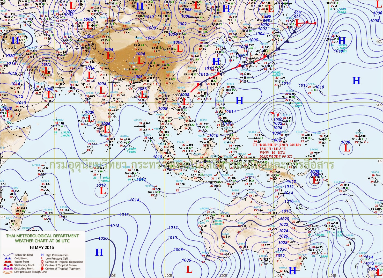
------------------------------------------------------------------------
Posted Friday 15th Night...And the Low descends off the Kerala cost...will now move NW, and merge (and dissipate) in the off shore trough as a Well Marked Low...

---------------------------------------------------------------------------------------------------------------------------------------------
Kanyakumari get very heavy rains, Tamil Nadu Rainfall ending 8.30 am 17.05.2015
The upper air cyclonic circulation over Lakshadweep area & adjoining Kerala coast extending upto 3.1 km above mean sea level persists. Entire Kanyakumari got good rains.in mm (min 40 mm)
Kottar, Kanyakumari - 126
Upper Kodayar, Kanyakumari - 124
Nagercoil, Kanyakumari - 114
Kulasekharam, Kanyakumari - 103
Tiruparappu, Kanyakumari - 95
Anaikidangu, Kanyakumari - 93
Ponneri, Tiruvallur - 91
Rajakkamangalam, Kanyakumari - 85
Koliporvilai, Kanyakumari - 82
Keeranur, Pudukkottai - 82
Mylaudy, Kanyakumari - 80
Vedaranyam, Nagapattinam - 79
Lower Kodayar, Kanyakumari - 77
Mambazhathuraiyaru, Kanyakumari - 76
Trichy Town, Trichy - 74
Kannimar, Kanyakumari - 73
Mullankivilai, Kanyakumari - 69
Mayiladuthurai, Nagapattinam - 68
Karuthancode, Kanyakumari -67
Nannilam, Tiruvarur - 65
Muthupet, Tiruvarur - 64
Aliyar, Coimbatore - 63
Golden Rock, Trichy - 62
Vettaikaranpudur, Coimbatore - 61
Pechiparai, Kanyakumari - 57
Kuzhithurai, Kanyakumari - 56
Krishnagiri, Krishnagiri - 53
Neyoor, Kanyakumari - 53
Suralode, Kanyakumari - 51
Nandhiyar Head, Trichy - 50
Tozhudur, Cuddalore - 49
Chinnakalar, Coimbatore - 46
Killiyoor, Kanyakumari - 45
Komaratchi, Cuddalore - 45
Uthagamandalam, Nilgiris - 45
Uttukkuli, Tiruppur - 44
Tiruvarur, Tiruvarur - 42
Chittar II, Kanyakumari - 42
Tiruvadanai, Ramanathapuram - 41
Adayamadai, Kanyakumari - 41
Munchirai, Kanyakumari - 40
Kulithalai, Karur - 40
Perunchani, Kanyakumari - 40
Navalaur Kottapattu, Trichy - 40
Chittar I, Kanyakumari - 40
Bhoothapandy, Kanyakumari - 40
Tiruvallur, Tiruvallur - 40
Its turn of Bangalore Suburbs to get Battered, Karnataka Rainfall ending 8.30 am 17.05.2015
The upper air cyclonic circulation over Lakshadweep area & adjoining Kerala coast extending upto 3.1 km above mean sea level persists.
in mm (min 50 mm)
Dasudi - 122
Duddamagge - 117
Kumaraswamy Layout - 109
Malur - 101
Doddamaragowdanahalli - 94
Hospete - 94
Jayapura (M) - 93
Araleri - 93
Kirugooru - 92
Halkurke - 90
T.M.Hosooru - 89
VatadaHosahalli - 86
Sowlanga - 82
Hosanagar - 80
Vagata - 79
Nelahal - 78
Doddamagaravalli - 75
Bomlapura - 75
Nagalamadike - 70
Aldur - 69
Karkala - 69
Kabini - 67
Sanivar Santhe - 67
Bangalore City - 66
Kainadu - 62
Masuru - 60
Kabbala - 59
K.Shettihalli - 59
Koppa - 56
Jagalbet - 56
Nanjangud - 56
Kolaganhalli - 54
Siddapura (K) - 53
Gauribidanur - 52
Gundulpet - 51
Harsikatte - 50
Ponnampet - 50
Bantwal - 50
Sringeri - 50
Kundana - 50
Gundlupet - 50
Yattinahallimk - 50
Dooars in West Bengal, the Western Ghats of Bengal gets battered, West Bengal Rainfall ending 8.30 am on 17.05.2015
The upper air trough from Sub Himalayan West Bengal and Sikkim to Odisha now runs from Sub Himalayan West Bengal and Sikkim and adjoining Bihar to south Chattisgarh, Jharkhand and Odisha extending between 1.5 km and 2.1km above sea level.in mm (min 20 mm)
Falakata - 181
Rongo - 135
Krishnanagar - 89
Diana 74
Nagrakata - 68
Murti - 60
NH31 - 60
Hasimara 62
Mahua - 56
Domohoni - 54
Burdwan - 54
Mathabhanga 53
Uluberi - 50
Jalpaiguri - 47
Sekahampore - 44
Alipore - 43
Buxaduar 40
Champasari 35
Mdinapore - 34
Alipurduar -32
Bagrakote 30
Coochbehar - 28
Katwa - 26
Sevoke - 20
Gazoldoba - 20
Bagdogra - 20
Chepan - 20
Malbazar - 20
Barobhisa 20
Andhra gets heavy rain for 2nd day, ending 8.30 am 17.05.2015
The upper air cyclonic circulation over Lakshadweep area & adjoining Kerala coast extending upto 3.1 km above mean sea level persists.in mm (min 45 mm)
Amalapuram - 98
Allavaram - 90
Gokavaram - 84
Tiruvuru - 78
Mogalthur - 78
Injaram 75
Bendamurulanka - 72
Therlam - 70
Polavaram - 70
Avanigada - 65
Srungavarapukota - 64
Chandarlapadu - 61
Lepakshi - 59
Mummidivaram - 59
Bheemavaram - 58
Chebrolu - 57
Yelamanchili - 56
Badvel - 56
Agali - 55
Katrenikona - 53
Sakhinetipalle - 52
Krishnavaram - 52
Rolla - 50
Sivala - 50
Pattiseema - 47
Isukapalle - 47
Kakarapadu - 46
Chalakur - 46
Duvva - 45
Cheepurupalle - 45
Ramagiri - 45
Trivandrum gets battered, Kerala Rainfall ending 8.30 am 17.05.2015
The upper air cyclonic circulation over Lakshadweep area & adjoining Kerala coast extending upto 3.1 km above mean sea level persists.in mm (min 25 mm)
Trivandrum AP - 142
Trivandrum - 98
Vaikom - 60
Kollam - 58
Palakkad - 57
Neyyattinkara - 56
Quilandy - 55
Perinthalmanna - 55
Varkala - 53
Nedumangad - 53
Maduppattey - 51
Punalur - 49
Chimoni - 45
Angadippuram - 40
Vadakara - 40
Perinagmala - 39
Mavelikkara - 35
Enamackel - 30
Kayamkulam - 30
Thenmala - 30
Mannarkad - 25
Manjeri - 25
Kurudamannil - 25
Parambikulam - 25
Alathur - 25
Kollengode - 25
Kozhikode - 25
Mattanur - 25
Tavanur - 25
Kamatchipuram in Dindugul records the All India highest 24 hrs Rainfall of 2015, Tamil Nadu Rainfall ending 8.30 am 16.05.2015
The cyclonic circulation over Lakshadweep and adjoining Kerala coast persists and extends upto 3.6 kms a.s.l. Dindugul and Tiruppur district gets super heavy rainfall. Kamatchipuram is recording 200 mm after 1997.in mm (min 40 mm)
Kamatchipuram, Dindigul - 224
Mulanur, Tiruppur - 168
Odanchatram, Dindigul - 160
Pongalur, Coimbatore - 116
Parappalar Dam, Dindugul - 116
Vadakadu, Dindugul - 116
Palladam, Tiruppur - 93
Thiruthuraipoondi, Tiruvarur - 93
Sulur, Coimbatore - 92
Vellakoil, Tiruppur
Coimbatore AP, Coimbatore - 89
Vedasandur Taluk Office, Dindigul - 85
Coimbatore South, Coimbatore - 75
Vedasandur TRS, Dindigul - 74
Sirkali, Nagapattinam - 73
Lathur, Kancheepuram - 72
Mettupalayam, Coimbatore - 71
Chengalpattu, Kancheepuram - 69
Kollidam, Nagapattinam - 68
Aravakurichi, Karur - 65
Udumalpet, Tiruppur - 64
Kottur, Tiruvarur - 62
Kattukuppam, Kancheepuram - 60
Dharamapuri, Dharmapuri - 56
Mayiladuthurai, Nagapattinam - 56
Kangeyam, Tiruppur - 56
Periyanaickenpalayam, Coimbatore - 55
Palani, Dindigul - 47
Dharapuram, Tiruppur - 46
Karaikal, Karaikal - 45
Acharapakkam, Kancheepuram - 43
Mahabalipuram, Kancheepuram - 42
Muthupet, Tiruvarur - 41
Annur, Coimbatore - 41
Thoppampatti, Dindugul - 41
Thiruvaiyaru, Thanjavur - 40
Dindigul, Dindigul - 40
Thirukalukundram, Tiruvallur - 40
Bhvangiri, Cuddalore - 40
TNAU, Coimbatore - 40
Telangana joins the party, Rainfall ending 8.30 am 16.05.2015
The cyclonic circulation over Lakshadweep and adjoining Kerala coast persists and extends upto 3.6 kms a.s.l.
in mm (min 30 mm)
Chennaraopet - 72
Khanapur - 68
Dichpalle - 63
Kerameri - 62
Kapulakanaparthy - 62
Medak - 61
Pargi - 61
Thangula - 57
Gandhari - 55
Narsampet - 52
Lingalaghanpur - 52
Aswapuram - 49
Kollapur - 49
Sirpur - 47
Doma - 46
Thimmaraopeta - 46
Bharampur - 46
Mangalparthy - 45
Shivanooru - 45
Madnur - 40
Nizam Sagar - 40
Manoharbad - 38
Kothagudem - 36
Gannaram - 35
Urkonda - 35
Gundala - 34
Kalher - 34
Jangaon - 34
Inole - 32
Adilabad - 32
Kathlapur - 31
Gopalpeta - 30
Kothapet - 30
Sangem - 30
Medapalle - 30
Ghanpur - 30
Sultanabad - 30
Pegadapalle - 30
Siddipet - 30
Wanaparthy - 30
Its the turn of Andhra Pradesh to get Heavy Rains, ending 8.30 am 16.05.2015
The cyclonic circulation over Lakshadweep and adjoining Kerala coast persists and extends upto 3.6 kms a.s.l.in mm (min 30 mm)
Tenali - 100
Atmakur - 93
Sangam - 84
Deebaguntla - 74
Halaharvi - 68
Jonnagiri - 59
Bommanahal - 58
Gorantla - 48
Irugulam - 47
Atmakur - 46
Bhudawarapupeta - 45
Guntakal - 43
Atmakur - 43
Yerraguntla - 43
Tuggali - 43
Kurnool - 42
Ellutla - 41
Sattenapalle - 38
Holagunda - 38
Ojili - 38
Kammarachedu - 37
Gudur - 37
Lepakshi - 35
Kondakamarla - 35
Hindupur - 35
Santhamaguluru - 35
Dibbanakal - 35
Adurupalli - 35
Kalyandrug - 35
Yellarthy - 35
Ganekal - 34
Chanti Bridge - 33
Alur - 30
Gonegandla - 30
Gudur - 30
Pedda Bodhanam - 30
Marutla - 30
Pulagampalle - 30
Maharashtra gets battered again from Unseasonal Rains, ending 8.30 am 16.05.2015
The cyclonic circulation over Lakshadweep and adjoining Kerala coast persists and extends upto 3.6 kms a.s.l.
in mm (min 20 mm)
Lamaj - 96
Wanadongari - 88
Gadchiroli - 72
Bramhapuri - 62
Chimur - 60
Ahupe - 53
Malewada - 50
Jalkot - 45
Deglur - 45
Wairagad - 44
Khanapur - 41
Walvan - 40
Kargaon - 37
Pisewadtha - 34
Wadgaon - 32
Mahalgaon - 32
Nagpur AP - 32
Sitabardi - 32
Pardi - 32
Hudkeshwar - 30
Brahamani - 30
Bhiwapur - 30
Hingana - 30
Dhanora - 30
Karajagi - 27
Nigade - 27
Tadwal - 26
Savale - 26
Maindargi - 26
Padloshi - 26
Porla - 25
Korchi - 24
Bhimashankar - 22
Takali - 22
Akkalkot - 22
Ambeghar - 22
Dasave - 21
Wagdari - 21
Anewadi - 20
Purada - 20
Chatgaon - 20
Adegaon - 20
Bhira - 20
Mahad - 20
Wai - 20
Heaviest Rains of the year in Karnataka, ending 8.30 am 16.05.2015
The cyclonic circulation over Lakshadweep and adjoining Kerala coast persists and extends upto 3.6 kms a.s.l. The rains were so widespread and the list very long, hence the cut-off is kept at 50 mm.
in mm (min 50 mm)
Navile - 142
Madadhakeri - 132
Basarakodu - 128
Anaberu - 111
Masavanaghatta - 105
Miyaru - 97
Neriya - 95
Balganur - 94
Marithotlu - 83
Channadevi Agrahara - 78
Ardi - 73
Mandikal - 72
Nuggehalli - 70
Kukkala - 69
Mayakonda - 68
Moka - 65
Mudenur - 65
Gonibeedu - 64
Dhanagalli - 62
Kadagadalu - 61
Hosadurga - 60
Santemarahalli - 60
Yelawala - 59
Mysore - 57
Virupakshipura - 56
Kurikuppa - 56
Gangasandra - 53
Mudabidri - 53
Sirchand - 53
Honnali - 52
Dudda - 52
Halekote - 52
Aldur - 52
Hanbal - 51
Mani - 50
Gandsi - 50
Shivani - 50
Belthangadi - 50
Hardarvati - 50
UAC enters 5th day, Madurai district gets historic rains, Tamil Nadu rainfall ending 8.30 am 15.05.2015
The cyclonic circulation over Lakshadweep and adjoining Kerala coast persists and extends upto 3.6 kms a.s.l.
in mm (min 30 mm)
Tirumangalam, Madurai - 142
Chellampatti, Madurai - 130
Kallikudi, Madurai - 108
Vembakkam, Thiruvannamalai - 108
Pondicherry, Puducherry - 83
Chithamur, Kancheepuram - 75
Karamadai, Coimbatore - 69
Cheyyar, Tiruvannamalai - 69
Mettupalayam, Coimbatore - 67
Peraiyur, Madurai - 65
Mandapam, Ramanathpuram - 63
Mannargudi, Tiruvarur - 60
Sedapatti, Madurai - 57
Trichy Junction, Trichy - 56
Thogamalai, Karur - 56
Rameswaram, Ramanathapuram - 55
Trichy Town, Trichy - 55
Viralimalai, Pudukkottai - 54
Sholayar Dam, Coimbatore - 48
Uthiramerur, Kancheepuram - 47
Marakkanam, Villupuram - 47
Tindivanam, Villupuram - 47
Acharapakkam, Kancheepuram - 46
Thirumanur, Ariyalur - 46
Madurai AP, Madurai - 44
Chetpet, Tiruvannamalai - 42
Sankaridurg, Salem - 41
Vaigai Dam, Theni - 41
Virudhunagar, Virudhunagar - 40
Coonoor PTO, Nilgiris - 40
Tindivanam Nicra, Villupuram - 40
Nilakottai, Dindigul - 39
Kariapatti, Virudhunagar -38
Maduranthagam, Kancheepuram - 38
Arakonam, Vellore - 37
Tiruttani, Tiruvallur - 37
Thangachimadam, Ramanathapuram - 35
Manjalar Dam, Theni - 35
Perungalur, Pudukkottai - 33
Vedasandur, Dindigul - 33
Vanur, Villupuram - 32
Palladam, Tiruppur - 30
Sholavandan, Madurai - 30
Golden Rock, Trichy - 30
Kallupatti, Madurai - 30
Aranmanaipudur, Theni - 30
No sign of UAC rains stopping in Karnataka, ending 8.30 am 15.05.2015
The cyclonic circulation over Lakshadweep and adjoining Kerala coast persists and extends upto 3.6 kms a.s.l.in mm (min 20 mm)
Mardhala - 75
Yedamangala - 72
Kadaba - 66
Narvepete - 50
Devamachi - 50
Heggadadevanakote - 50
Mundkuru - 49
Koila - 49
Hanbal - 46
Virajpet - 45
Puttur - 38
Talwad - 36
Harle - 35
Kuppepadavu - 35
Bhalki - 32
Betageri - 31
Urubage - 30
Hura - 30
Hosagavi - 30
Siddapura(K) - 30
Kanivedasarahalli - 30
Terakanambi - 30
Hosakere - 29
Ponnampet - 26
Napoklu - 25
Chikkati - 25
Galibeedu - 25
Kuruchu - 25
Arehalli - 25
Uppinangady - 24
Udupi - 23
Srimangala - 23
Kukkala - 21
Kokkada - 20
Gokak - 20
***************************
IMD has put up forecasted arrival date of Monsoon . The forecast shows a wide window...onset will be between 26th May - 3rd June. Vagaries has shown 3rd/4th June in the MW forecast put up on May 3rd in MW-3.
Posted Thursday (14th) Night.. 1. UAC formed off the Kerala coast may descend as a Low off Kerala on 15th. As mentioned in vagaries. may strengthen to WML and track NW.
2. UAC has formed in South Andaman Sea. May descend as aLow by 16th, and pull in the South West Monsoon in South Andaman by 17th/18th May.
************************************
UAC pounds Tamil Nadu with widespread rainfall, ending 8.30 am 14.05.2015
The cyclonic circulation extending upto 5.8 kms a.s.l. over Lakshadweep area & neighbourhood now lies over Lakshadweep and adjoining Kerala coast. This year summer rains have given close to 50% of the NEM rains. Over 400 stations have reported rainfall above 10 mm.in mm (min 40 mm)
Illayangudi, Sivaganga - 118
Pollachi, Coimbatore - 96
Rajapalayam, Virudhunagar - 94
Kudumiyanmalai, Pudukottai - 83
Pillur, Coimbatore - 70
Kumarapalayam, Namakkal - 66
Periyanaickenpalayam, Coimbatore - 64
Manur, Tirunelveli - 63
Ketti, Nilgiris - 62
Rameswaram, Ramanathapuram - 61
Andipatti, Theni - 60
Sholayar Dam, Coimbatore - 60
Annavasal, Pudukottai - 59
Kodaikanal, Dindigul - 58
Kodaikanal Boat Club - 57
Kundha Bridge, Nilgiris - 56
Coonoor, Nilgiris - 56
Ammapet, Erode -56
Coonoor Pto, Nilgiris - 55
Manamelkudi, Pudukkottai - 54
Kattumavadi, Pudukottai - 54
Devakottai, Sivaganga - 54
Sarcarsamakulam, Coimbatore - 53
Keeranur, Pudukkottai - 52
Kollimalai, Namakkal - 49
Pegumbahallah, Coimbatore - 48
Viralimalai, Pudukkottai - 48
Kalugumalai, Toothukudi - 48
Nagudi, Pudukottai - 47
Vaigai Dam, Theni - 46
Paluvidudhi, Karur - 46
Kadavur, Karur - 46
Uttamapalayam, Theni - 46
Sivagiri, Tirunelveli - 45
Mayalampatti, Karur - 45
Vaiyampatty, Trichy - 43
Palladam, Tiruppur - 42
Pappakudi, Tirunelveli - 42
Srivilliputhur, Virudhunagar - 42
Valparai Taluk Office, Coimbatore - 41
Bodinaickanur, Theni - 40
Cuddalore, Cuddalore - 40
Valparai Pto, Coimbatore - 40
Pamban, Ramanathapuram - 40
Virudhunagar, Virudhunagar - 40
Avalanche, Nilgiris - 40
Kollidam, Nagapattinam - 40
Coimbatore, Coimbatore - 40
Vedasandur, Dindigul - 40
Pune breaks All time 24hrs May rainfall record, Maharashtra Rainfall ending 8.30 am 14.05.2015
The cyclonic circulation extending upto 5.8 kms a.s.l. over Lakshadweep area & neighbourhood now lies over Lakshadweep and adjoining Kerala coast. Pune city broke his all time record for wettest day in May in 24 hrs by recording 103 mm.
in mm (min 25 mm)
Pune Pashan - 120
Pune City - 103
Pune Cagmo - 100
Chakan - 61
Mukhed - 55
Yerwada - 55
Samsherpur - 52
Pune AP - 50
Pirangut - 49
Pune Lavale - 48
Koregaon - 48
Bhutonde - 46
Kadus - 44
Moha - 43
Nagbhir - 40
Pisewadtha - 37
Khadkwasla - 36
Borad - 35
Kalmb - 34
Waki - 33
Satara - 31
Rajgurunagar - 31
Khed - 31
Thoseghar - 29
Savada - 28
Akole - 28
Bhosari - 28
Pratappur - 27
Arangaon - 27
Undirgaon - 27
Welu - 27
Hnumant - 27
Tathwade - 26
Pune Chinchwad - 25
Nandurbar - 25
Taloda - 25
Chimbhla - 25
Shibalapur - 25
Jahur - 25
Rajugurunagar - 25
Yeotmal - 25
Sandvali - 25
Ghodegaon - 24
UAC contiues to give heavy Rains to Karnataka, ending 8.30 am 14.05.2015
The cyclonic circulation extending upto 5.8 kms a.s.l. over Lakshadweep area & neighbourhood now lies over Lakshadweep and adjoining Kerala coast. 300 stations reported rainfall above 10 mm. Hence, cutoff is kept at 30 mm. The rains were heavy on Shimoga district.in mm (min 30 mm)
Hosanagar - 110
Baad - 105
Karwar - 97
Paduvari - 71
Honavar - 66
Sooleripaalya - 56
Hosadurga - 54
Bhagamandala - 52
Chikadadakatte - 51
Humcha - 51
Hunchdakatte - 50
Chikkabasur - 47
Honnali - 44
Kolkunda - 41
Anavatti - 41
Shivanasamudra - 40
Gersoppa - 40
Kuppagadde - 39
Kakkeri - 39
Hangaraki - 39
Muguru - 37
Aralasurali - 37
Shimoga - 36
Gundal - 33
Shanthahalli - 33
Siddapura (K) - 32
Tyagadabaji - 32
Chandragutti - 32
Aralagod - 32
Malali - 31
Ramagiri - 31
Kere - 30
Gogi - 30
Hiremannapur - 30
Bukkambudi - 30
Lokkanahalli - 30
Tegur - 30
Kanivedasarahalli - 30
Haunsabhavi - 30
Kodihally - 30
Halageri - 30
Napoklu - 30
Arasalu - 30
Ramgiri - 30
Kogar - 30
Kanakapura - 30
Super Rains continue in Kerala, ending 8.30 am 14.05.2015
The cyclonic circulation extending upto 5.8 kms a.s.l. over Lakshadweep area & neighbourhood now lies over Lakshadweep and adjoining Kerala coast.in mm (min 15 mm)
Chittur - 115
Kollengode - 107
Thariode - 87
Vyttiri - 85
Alathur - 82
Mankara - 74
Palakkad - 64
Tavanur - 55
Pookot - 54
Ponnani -48
Vellanikkara - 48
Perinthalmanna - 45
Manjeeswaram - 43
Ottappalam - 38
Irinjalakuda - 37
Irikkur - 36
Lower Sholayar - 32
Kuttiyadi - 31
Idamalayar - 30
Taliparamba - 30
Thrithala - 29
Mattanur - 29
Piravom - 29
Thodupuzha - 26
Mannarkad - 24
Vadakkancherry - 24
Peermade - 20
Idukki - 17
Aryankavu - 17
Pattambi - 17
Nilambur - 16
Neeriyamangalam - 15
Mananthavady - 15
Pambla - 15
Sengulam - 15


8 comments:
That is right Rajesh. It is WML or LOW formed in lower latitudinal westerlies near Kanyakumari or south of Kanyakumari. This will give push for SWM onset in Arabian Sea.
But the tilly tallying power house "MASCARENE HIGH" will play a decisive role in SWM rainfall.
In Badlapur at 6pm,Gusty winds from SE direction, which may be of 50kmph in gust blown all the soil's dust in the air and visibility got dropped to less than 1km.. Trees were bending to fullest but later clouds broken up and rain was missed by 10 to 20kms margin.. Winds lasted for 30 to 40mins..
Nearby Karjat got 11 mm rainfall from this Storm.
Why have regions around the Eastern MP, Chattisgarh and adjoining Odisha regions been getting pre monsoon showers ?
These showers were locally prominent, and overall, the MP and Chattisgarh region shows deficiency in rainfall.
Heat wave conditions which prevailed over central India for some days in the initial half of the 1st week of May got abated subsequently with the re-starting of convective rains.
Now, this was due to slow moving, deep amplitude westerly trough to the west of the sub-continent.
However, the upper level divergence ahead of this trough (WD), when combined with moisture incursion and localised vorticity provided conducive conditions for convective activity. So, a trough at 850 hp extended from the above cyclonic circulation to northeast Madhya Pradesh across Jharkhand and north Chattisgarh on 8th.
Active Western Disturbance during the later part of the week led to further delayed in the development of the 'Seasonal Low' over northwestern parts of India and Pakistan.
Pradeepji- it is refreshing to see interiors of TN to receive good rains after 8-10 years of drought or scarcity...boon to farmers apparently Sri Lanka also escaped drought after late 2014 - 2015 good rains.. Sri Lanka was also facing 5-8 years of drought and .. both TN/Sri Lanka mercy of NEM..
SSET, from last NEM interior and south TN are getting way above rainfall. Even drought areas like Tirunrelveli, Karur, Tiruppur and thoothukudi.
Only concern is Kancheepuram, Chennai and Tiruvallur districts
now focus only on sw monsoon. north east monsoon is past.past will never come.
so hopefully we can talk abt sw monsoon 2015 Arrival and progress.
Moshin, i know that. Hope u understand that they are getting excess rains from NEM till this date including Pre-monsoon.
Parambikulam is one of the best place in this planet to visit. And the best part about that place is staying at parambikulam forest. Anyways thanks for sharing this information in here.
Parambikulam Forest Stay
Post a Comment