UK weather maps show 30 hours of snowfall for May across 13 counties
New weather maps show parts of the UK are set for a return to wintry conditions next week [NATIONAL NEWS]
The UK could be bracing itself for an extended period of wintry weather next week, with new meteorological charts suggesting approximately 30 hours of uninterrupted snowfall across multiple counties. 

A bitterly cold Artic Blast of freezing air will engulf the U.K.
------------------------------------------------------------------------------
Winter’s End Is Written in the Clouds

Rare May Snowfall Blankets Greece as Temperatures Plummet
This year’s May Day has officially been recorded as the coldest in Greece in the last seventy years, as a sudden weather shift brought “winter” back to many parts of the country.
The country experienced an extraordinarily unseasonal and abrupt cold front, bringing sudden temperature drops of more than 10°C (approximately 18°F) and rare late-spring snow to regions with higher altitudes across the country early Saturday morning.
The sudden weather shift transformed typical spring landscapes back into midwinter scenes that resembled more of a cold December day rather than the 1st of May.

------------------------------------------------------------------------------------------------------------------------------------------------------
Certainly not the Warmest of the Years...More news of Record Colds..(30th January 2016)
1. 29 Jan 2016 – Snow fell on Kuwait on Thursday morning for the first time in the country’s history. For the first time in the country’s history this morning a small amount of snow fell in Kuwait.

2. 27 Jan 2016 –Vietnam – Worst cold in history of Nghe An Province Temperatures dropped to minus five degrees Celsius in some parts.

Nghe An is among many localities in the central and northern regions to be hit the past several days by the worst cold spell in the country in 40 years.
3. Thailand – More deaths reported from cold weather
The province’s resort Phu Thub Berk reported a temperature of 0 C with poor visibility due to fog.In a chilly Sakhon Nakhon province at 7-9 C, the provincial governor sent 6,000 blankets to affected residents in 18 districts.
4. Turkey looks like Siberia – Single-story houses completely buried under the snow.

Snowfall in the city continued day and night and the snow height passed two and a half meters (8.2 ft), the most snowfall in recent years.Air temperature is minus 20 degrees and people are waiting for the opening of the roads that are closed in many villages.
5.Parts of Vietnam see first snow EVER
The lowest temperature at Pha Din mountain pass, Lai Chau and Sa Pa reached at minus 4 degrees Celsius. The highest temperature in the tourism area of Mau Son was at minus 3 degrees Celsius; and 5 below zero degree Celsius at Moc Chau.
The current extremely dangerous cold affecting to the northern region has damaged production, crops and caused death of tens of cattle.
Excerpts from Robert's Ice Age and Thanks to Argiris Diamantis for the links
The severe Cold in the East Asia Region, with rare snows in taiwan and even High lands of Thailand. ( see here http://www.vagaries.in/2016/01/posted-tuesday-night-western.html...)..
Ten years ago today, Al Gore said that we had ten years to save the planet, according to Rush Limbaugh. If we didn’t, “life on earth would be totally unlike it was ten years ago.”“Well, here we are ten years later, and nothing’s changed,” says Rush. “It isn’t any hotter than it was.”
---------------------------------------------------------------------------------
------------------------------------------------------------------------------------------------------------------------------------------------------------------
25th December 2015....U.S. Heat !!
Christmas heat wave breaks U.S. records and confuses everyone
Saturday 8th August 2015:
Typhoon Soudelor is now bringing rain to the coast of China. In Taiwan it produced more than 50 inches of rain in some places
The GPM core observatory satellite continued to provide excellent coverage of Soudelor. (Pictures of Friday , but would like Vagarians to see and study these unique images)..
An excellent coverage of Typhoon Soudelor...A very informative and interesting image for all meteorologists.. This one image of core obs Satellite and 3D Microwave mage combination.

Rainfall data from GPM's Microwave Imager (GMI) and Dual-Frequency Precipitation Radar (DPR) instruments revealed very heavy rainfall in spiraling bands rotating around a decaying inner eye wall.
Rainfall was measured by GPM falling at the extreme rate of over 122 mm (4.8 inches) per hour within an intense feeder band spiraling around the southwestern side of the typhoon. 3-D reflectivity data from GPM's radar (Ku Band) also revealed typhoon Soudelor's rainfall structure. The tallest thunderstorm tops in this feeder band were found to reach heights of almost 14km (8.7 miles).

--------------------------------------------------------------------------------
Posted 5th August 2015:
Cat 3 Typhoon Soudelor Threatens Taiwan And China
Typhoon Soudelor's sustained winds were 105 kts,(now at 185 kmph) when the GPM core observatory satellite flew above on August 5, 2015 at 1051 UTC. A rainfall analysis was made from data collected from GPM's Microwave Imager (GMI) and Dual-Frequency Precipitation Radar (DPR) instruments. This analysis showed that Soudelor was very large and had a well defined eye. Intense feeder bands are shown spiraling into the center.

This view from the south shows the 3-D vertical structure of rainfall within Soudelor.
The Joint Typhoon Warning Center (JTWC) predicts that typhoon Soudelor will continue to be a powerful typhoon and winds are predicted to increase to 120 kts (138 mph) before impacting Taiwan in a couple days.
----------------------------------------------------------------------------
Posted 20th July:
Last Week's Typhoon " Nangka"...some Facts and Superb 3D Satellite Image:


What was not unusual is that the highest rainfall totals occurred in mountainous areas facing the Pacific Ocean. The highest reported rainfall total in Japan was 745.5 millimeters (29.35 inches) in Kamikitayama village, Nara prefecture, south of Osaka.

-------------------------------------------------------------------------------------------------------------------------------
Heat Wave in Western Europe..Some Hot Spots on 4th July:
Spain:
Ciudad Real 40.0 °C
Almagro Airport 40.0 °C
Granada Airport 39.0 °C
Palma 39.0 °C
Portugal:
Évora 35.0 °C
Beja 34.0 °C
France:
Mâcon 39.0 °C
Le Luc 38.0 °C
Nancy/Ochey 38.0 °C
Nancy/Essey 38.0 °C
Germany:
Seehausen 39.0 °C
Lahr 38.0 °C
Mannheim 38.0 °C
Mannheim/Neuostheim 38.0 °C
Waibstadt 38.0 °C
Wiesbaden 38.0 °C
Switzerland ( The Cool Place):
Geneva Intl. Airport 37.0 °C
Beznau 36.0 °C
Binningen 36.0 °C
Mathod 36.0 °C
Delémont 36.0 °C
With record temperatures over 104 degrees Fahrenheit (40 degrees Celsius) alerts are being issued around the continent about the dangers from the heat predicted to last into early next week.
The heatwave affecting France, Great Britain, Belgium, the Netherlands, Luxembourg, Switzerland, Spain, Italy, Portugal, Poland, and Germany has triggered massive power failures affecting almost one million homes in northwest France, the cancellation of outside events and athletic competitions, disruptions in train and subway service.
The southwest of France, southern Spain and Portugal reached temperatures over 107 degrees (42 Celsius). Cordóba, Spain, recorded a blistering 110.6 (43.7 Celsius).
The heat will be most persistent in Spain, France, Hungary, Poland, the Netherlands, Germany, Austria, Switzerland, Slovakia, Czech Republic, the Ukraine, Belarus and Lithuania.
(Forbes)
---------------------------------------------------------------------------------------------------------------
1st July 2015:
1st July, U.K....It’s the hottest July day on record - 36.7C
The temperature has soared at Heathrow to make this the hottest day in July since records began. That’s 0.2C higher than 2006’s record.The hottest temperature on record for the month of July is 36.5C at Wisley, Surrey on 19 July 2006.
As temperatures reached 36.7 °C at Heathrow, commuters were facing difficult journeys on the London Underground. One platform at Kings Cross underground station recorded 33 °C however the temperature on tubes is believed to be even hotter.
Charlotte Dalen, originally from Norway but now living in London, said: “It was pretty warm and very smelly. People were waving pamphlets to keep cool but it didn’t look like it was helping.”
The hottest day in the UK ever recorded was 38.5C on 10th August 2003 in Faversham, Kent.
Prince Charles Tweeted "Britain, one has provided you with some sunshine from Greece, who appear to be having a Closing Down Sale."
At Wimbledon, even an Australian like Bernard Tomic complained of dizzying heat: temperatures hovering near 34 degrees made it one of the hottest days on record at the tournament.
U.K. other hot spots on 1st July:
London Heathrow Airport 37.0 °C
Northolt 36.0 °C
Gravesend Broadness 35.0 °C
St. James's Park 35.0 °C
Wittering 35.0 °C
Western Europe on 1st July: Vichy/Charmeil ( France) 40.0 °C
Parc Montsouris ( France) 40.0 °C
Granada Airport ( Spain) 40.0 °C
Toledo ( Spain) 39.0 °C
Siirt Airport ( Turkey) 39.0 °C
Paris-Le Bourget Airport ( France) 39.0 °C
Westdorpe (2 m, Netherlands) 36.0 °C
Mâcon ( France) 36.0 °C
Guadalajara ( Spain) 36.0 °C
Nancy/Essey (France) 36.0 °C
Sion Airport ( Switzerland) 35.0 °C
Geneva Intl. Airport ( Switzerland) 35.0 °C
Geilenkirchen (90 m, Germany) 35.0 °C
Lille (Belgium) 35.0 °C
Hook of Holland ( Netherlands) 35.0 °C
Weather alerts across western Europe as heatwave sets in
Forecaster Meteo France said Paris reached 39.7 C, the highest temperature recorded in July since 1947, and the second-highest since record-keeping began in 1873.
French officials said the heat wave was just beginning. On Tuesday, southwest France saw temperatures reaching 42 C (107 F) and Cordoba in southern Spain recorded nearly 44 C (111 F).
Spanish authorities said the past week brought record June temperatures, with Madrid recording its highest temperature in 95 years as thermometers came close to 40 C (104 F).
---------------------------------------------------------------------------------------------------------------------
14th January 2015:
The lowest latitude for seasonal sea ice formation in the world.
Located off the east coast of Russia, the Sea of Okhotsk stretches down to 45 degrees North latitude, and sea ice forms regularly in the basin. In fact, it is the lowest latitude for seasonal sea ice formation in the world. On January 4, 2015, the Moderate Resolution Imaging Spectroradiometer (MODIS) on NASA’s Terra satellite captured this image of the ice-covered Sea of Okhotsk.

Every winter, winds from East Siberia, frigid air temperatures, and a large amount of freshwater flowing out from rivers promote the formation of sea ice in the region. Much of the freshwater comes from the Amur River, one of the ten longest rivers in the world.
From year to year, variations in temperature and wind speed can cause large fluctuations in sea ice extent. The sea spans more than 1,500,000 square kilometers (600,000 square miles), and ice cover can spread across 50 to 90 percent of it at its annual peak. On average, that ice persists for 180 days.
-----------------------------------------------------------------------------------------------------------------------------
9/2014
December 18, 2014
CRAZY WEATHER - The heavy snowfall of Moscow
by Alessandro Azzoni, &Cioppero
The Atlantic currents have come in part of Russia bringing much freezing rain, or rain falling on frozen ground, freezing after a few minutes. In Moscow, however, the thick layer cold caused by Russian Anticyclone has meant that the temperature remained below zero to about two degrees. The result is an intense snowfall, which persisted throughout the day on Friday with a layer snowy really abundant, amounting to about 25-30 cm even in the heart of the great metropolis. Snowfall is probably even in the next days.
See the Temperature (Max and Min ) dropping in Yakutsk, Russia last week !!


Japan – Heavy snowfall causes some buildings to collapse
by ROBERT on DECEMBER 18, 2014
More than 70 cm (28 inches) of snow fell in 24 hours in the northern island of Hokaido, leading to widespread travel disruption and some buildings to collapse.
At least five people have died.
The point is that snowfalls were supposed to be just a thing of the past. I want people to remember those words from Dr David Viner. (See http://iceagenow.info/2011/10/snowfalls/ )
-------------------------------------------------------------------------------------------------------------------------
8/2014
New York Walloped by Lake Effect Snow
On November 5, 2014, spiral-shaped Super Typhoon Nuri lost its eye and began to morph into a comma-shaped extra tropical cyclone as it approached the cool waters of the Bering Sea. After undergoing a rapid strengthening process meteorologists call “bombogenesis,” what emerged was one of the most intense extra tropical cyclones ever recorded in the North Pacific, a storm with a minimum central pressure that plunged to 924 millibars. (For comparison, the all-time record low for an extra tropical cyclone is 913 millibars.)
Two weeks later, the downstream effects of the Bering Sea Superstorm lingered on—in the form of a massive lake effect snowstorm that dropped several feet of snow in communities just east of Lake Erie. While the Bering Sea Superstorm did not directly cause the snow event in New York, it did set the stage for it by nudging the jet stream into an unusual shape that sent a pulse of cool Arctic air south over the central United States.
As that dry, cool air rushed over the Great Lakes, it picked up moisture from the comparatively warm waters of the lakes, creating long cloud lines known as cloud streets. The Visible Infrared Imaging Radiometer Suite (VIIRS) on Suomi NPP captured this view of clouds streets moving south-east across Lake Superior and east across the other lakes on November 18, 2014.
When clouds reached the edges of the lakes and crossed back over land, they cooled down even more. (Air is generally cooler over land than water, and also the clouds get pushed upward by the land surface.) Lower temperatures and increased altitude make it harder for clouds to retain moisture, so instead they drop it as snow. In this case, the west-southwesterly winds lined up perfectly with the long axis of Lake Erie, so the air was able to pick up an extraordinary amount of moisture. According to the National Weather Service, more than 60 inches (152 cms) of snow had fallen by November 18 and more was forecasted to fall.


Captured at the same moment as the natural-colour image (top), the false-colour image (bottom) was made by assigning blue light to show up as red, and two shortwave infrared bands to show up as green and blue. This band combination is useful for distinguishing between snow on the ground (dark pink), ice clouds (light pink), and water clouds (white). Bare ground is green.
----------------------------------------------------------------------------------------------------------------------------------------------------------------------------------------------------------------------------------------------------
7/2014
Polar Vortex Returns ...Cold Wave To Grip Eastern U.S.
It is a general area of low pressure aloft that it is typically close to the North Pole in summer but spreads out and changes shape in winter. The launch pad for the widespread use of polar vortex came when last winter's circumpolar cortex expanded southward, but one part of it stretched out much more than usual. Cold air then had a straight shot from northwestern Canada right into the Midwest and on eastward...Elliot Abrams (Accuweather).


The polar vortex is a large pocket of very cold air, coming from a "trough" or a "Rossby Wave" from the 500-200 level Jet Streams.typically the coldest air in the Northern Hemisphere, which sits over the polar region. Occasionally, this pocket of very cold air can get dislodged farther south than normal, leading to cold outbreaks in Canada and the U.S.
Arctic air associated with the polar vortex will lunge into the North Central United States early next week and will expand southward and eastward
The coldest weather of the season so far will extend from the Dakotas to Texas and the Interstate-95 corridor by the end of the week. The outbreak of arctic air will be long-lasting and may linger well past the middle of the month.
In New York City, it is possible temperatures may not go over Freezing on one or more days from late next week into next weekend.
The reason the Polar Vortex is a term being used so much lately is because some were blaming climate change on why it sank so far south and remained last winter.
The Rossby Wave is mainly unique to the American Continent. What the Sub Continent gets are Rossby Type Waves when the Jet streams dip into Western Disturbances.
6/2014
Friday 7th October 2014:

Bombs away! North Pacific storm to explosively intensify in historic fashion
Rapidly Strengthening Monster Storm May Become Most Intense Ever for Alaska
Strongest Storm in the World to Approach Alaska
Bering Sea In Crosshairs of Monster Storm
5/2014
Polar Vortex Returns to U.S. Mid West....from the Ohio Valley to the upper Mid-Atlantic.


The Polar plunge is will make the cooler air move intothe upper layers, causing massive unstability.
Very Cold air and Severe thunder storms will lash the U.S. Mid West, from Saturday. In what is the warmest time of the year, we will see temperatures like 15-18c range in Minneaplois and around 21c in Chicago and Detriot...some palces will see days around 7-10c below the normal.
Nights will be colder, with some places going down to 5c.
Excerpts from Accuweather
---------------------------------------------------------------------------------------------------------------------------------------
4/2014
Heat Wave in Oman..Hot for April !...From Times of Oman
A blistering heatwave has hit Oman with temperatures soaring above 40 degrees Celsius in almost all governorates of Oman. Millions of people all across the country looked for ways to cool off during the day.
The capital city also suffered through intense heat on Monday, as the mercury reached 39 degrees Celsius in the afternoon, causing those working outside to rest in shaded areas under nearby trees, while children opted for fun in water-pools.
According to the Meteorological Department of Oman, the temperature in the city is expected to be marginally lower at 37 degrees Celsius on Tuesday, with no sign of significant relief from the heat and dry weather for Muscat residents.

Ibra, Haima, Ibri and Rustaq saw the maximum temperature of 40 degrees Celsius being recorded. The lowest temperature in these cities was between 18 and 26 degrees Celsius on Monday.
According to forecasts by weathermen, Samail, Nizwa, Bahla, Rustaq, Ibri, Fahud, Duqm, Haima, Madha, Mudhaibi, Ibra, Marmul and Thumrait will have maximum temperatures of between 40 and 42 degrees Celsius on Tuesday, while the minimum temperatures will reach 24 to 29 degrees Celsius in these cities.
For those who want to cool off, away from the bustle of Muscat and avoid the ongoing heat wave, Jebel Shams and Jebel Qamar are expected to be attractive.
The maximum temperature in Jebel Shams will be a pleasant 21 degrees, and minimum 15 degrees, Celsius. Similarly, Jebel Qamar will have a maximum 23 degrees and minimum 20 degrees Celsius. Meanwhile, Qairoon Hariti is expected to have a maximum temperature of 25 degrees Celsius and minimum 21 degrees Celsius. Jebel Samhan will have a maximum of 24 degrees Celsius and minimum 21 degrees Celsius, according to the forecast.
3/2014
NEW TORNADO WARNING for Robeson County, NC heading NE! Take cover!

TORNADO WARNINGS for Dinwiddie, Prince George, Surry, Sussex, Essex, Richmond and Westmoreland Counties, VA heading NE! Doppler indicated tornado on both cells! Take cover now!

2/2014
On January 9, Lake Erie was reported to be 90 percent ice covered, and nearly a quarter of the surface area of the five Great Lakes was covered. Ironically, the ice cap on top of the lakes stifled the persistent “lake effect” snowstorms that had buried Buffalo, New York, and other towns during the deep freeze of early January. Cold arctic winds blowing across the frozen lake could no longer pick up moisture.

1/2014
Interesting Reading and Records for Weather Enthusiasts:
World Wide Weather Extreme Records for the Year 2013...Of -Course, Vagaries has not covered all records and many may have been missed in this report..
24th Dec 2013
The MSL pressure of 936.8 mb recorded at Stornoway at 1300 GMT today is the the lowest value measured anywhere in the British Isles since 1886. It beats the previous value of 937.6 mb recorded on 20 December 1982, also recorded in Stornoway. The lowest ever value recorded on land in the British Isles is 925.4 mb, at Ochtertyre (Perthshire, nr, Crieff) on 26 January 1884 - this record remains unchallenged today.
8th Nov
Typhoon Haiyan is battering the central Philippines with sustained winds of up to 315 km/h. Meteorologists say that if initial estimates based on satellite images are borne out, it could be the most powerful storm ever to make landfall.
12th Oct:
Cyclone Phailin>> The India Meteorological Department confirmed that Phailin made landfall over Gopalpur on Saturday evening with winds over 200 km/h. Phailin reached peak intensity Friday night into Saturday when the storm was the equivalent to a Category 5 hurricane or super typhoon.
16th Oct:
the wrath of Wipha, the storm now races away from the country leaving behind both destruction and death. Oshima, a small island south of Tokyo, reported 824 mm of rain from the storm in less than 24 hours. The long duration of heavy rainfall caused fatal landslides. The Associated Press reported 17 deaths so far, many from Oshima. With 44 people still unaccounted for, it is possible the death toll will continue to rise. Winds of hurricane force lashed parts of the greater Tokyo area as rainfall totals reached between 150 and 300 mm. The center of Wipha tracked within 50 to 100 miles of Tokyo early on Wednesday morning, local time, having top sustained winds comparable to a minimal hurricane.
1-2nd August:
Some of the hot temperature observations include 35C in Rome, 34C in London, 33C in Frankfurt and 38C in Madrid. While cooler weather pressed into England Friday, the heat was still on in central Europe. Florence, Italy, climbed to 37C late in the afternoon while Frankfurt reached close to 35C.
2nd
So far this summer has been unusually warm across Alaska; temperatures in Barrow and Anchorage have averaged approximately 1.7 degCs above average, while temperatures in Fairbanks have averaged nearly 2.5 degC above average. Although Anchorage has averaged above normal, the city has yet to break any daily temperature records this summer. The persistent warmth has managed to break a different type of record for the city, however. From July 17 to July 31, Anchorage either reached or climbed above 70F, a stretch of 15 days. This broke the old record set in 2004 when the city had a stretch of 13 consecutive days of at or above 70. In Fairbanks, the high soared to 83F on Saturday. The high has reached 80F or higher for 33 days this summer. That is the most such days in Fairbanks, since record-keeping began in 1904. The average number of days Fairbanks reaches 80 degF or warmer is 11.
6th/7th Aug:
The temperature climbed to 40.6C at Xujiahui Observatory, Shanghai. This equalled the previous all-time record high temperature there. On Wednesday 40.8C was reached.
1st June:
Much of Europe, the United States of America, north-west Russia and parts of Japan had a much colder than average spring (1 March to 1 June), which ended with heavy rain in some European countries.
16th June: 16th
Onset of the southwest monsoon has taken place deep into Pakistan as many as four weeks earlier than usual. Monsoon onset was 13 June 2013, in Delhi, almost two weeks earlier than average. The 15 June onset at Karachi and Islamabad was more like three weeks ahead of schedule. The abnormally early advance of the seasonal weather phenomenon has left unusually early soaking rain in many parts of Pakistan and northwestern India. The characteristic pre-monsoon heat has also been beaten back, thanks to widespread rain-cooled air.
26th-30th April:
At least 13 people have died and four other are missing in flash floods in Saudi Arabia. Deaths were reported in the capital Riyadh, Baha in the south, Hail in the north and in the west of the country The Saudi Civil Defence Authority urged people to avoid valleys and plains that have been flooded by the heavy rainfall that began on Friday. The rain is said to be the heaviest experienced by the desert kingdom in more than 25 years.
29th April:
Spain has been struck by unseasonal weather which has seen snow falling across the country. Extreme weather warnings are in place in 18 provinces, with small roads blocked as temperatures continue to hover around freezing. A snow depth of 18 cm was reported at the ski resort of Navacerrada, in the Sistema Central mountains, northwest of Madrid. The wintry weather in April's last days resulted from the arrival of low pressure from the Mediterranean.
16th March
Record snow fall followed by a rise in temperatures has caused flooding in some parts of Moscow. The heaviest March snowfall for 50 years saw almost a month's worth of snow fall in 24 hours. Authorities say they have cleared 300,000 cubic metres of snow since Wednesday, with a predicted drop in temperatures expected to turn what is left of the melted snow back into ice.
19th March
Snow whitened parts of the northern U.K. on Tuesday as winter's cold lingered over Europe.
March 2013:
Unusual cold and snow made for a memorable month of March 2013 in the UK and much of Europe. The month as a whole was coldest in what amounts to essentially the northern half of Europe, where average monthly temperature was at least 2-4 degC below normal. In Germany, one city, Leipzig, registered a mean reading more than 5 degC below normal. So cold was March that it, in some spots, the month that normally ushers in spring was the coldest month of the winter season, even undercutting January. Significant March cold also stretched over much of France, Spain and Italy to the northern Balkan region. Exceptional falls of snow covered parts of the UK, the Low Countries, Germany, France, Austria, Poland, Hungary, Russia, Ukraine, Belarus and more.
9th January:
The Bureau of Meteorology confirms extreme temperatures will continue for the next week. The heatwave had broken national records. On Monday the average maximum daily temperature record for Australia was broken at 40.33C. The previous record, 40.17C on 21 December 1972, was held for 40 years. The daily average maximum temperature yesterday (8 January 2013) is a close third at 40.11C. The number of consecutive days where the national average maximum daily temperature exceeded 39C has also been broken this week-seven days (2-8 January 2013), almost doubling the previous record of four consecutive days in 1973. The heat wave, which is pushing the limits of previous temperature extremes, has required an adjustment of the scale used to represent forecast temperatures with new colours representing 50-52C and 52-54C.
Thanks to Roger Brugge for some of the Information.
March Mumbai Range in a day: Mumbai SCZ .. 39.5 c / 15.6 c (daily range 23.9 c ) in early March 2013
--------------------------------------------------------------------------------------------------------------------------------------------------------------------------------------------------------------------------------------------------------------------
18/2013;
In fact, it was not until Jan. 22 this year that ice cover compared with the amount on the lake now. The laboratory predicts that up to 62 percent of the Great Lakes will be frozen over this winter, above the long-term average of 55 percent.
From Chicagoland
17/2013: Rare snow blankets Middle East
A winter storm brought severe weather to the Middle East, forcing the closure of roads and schools and blanketing much of the higher-altitude areas with snow and ice.
Eastern Suburb of Cairo, Madinaty Town, 60 kms East of Cairo got its rare snowfall on 13th December...Cairo was very cold at 8c as the maximum and 5c at the lowest with day long light rains.
 Madinaty Town
“Snow coated domes and minarets Friday as a record Mideast storm gave Egyptians a rare glimpse of snow in their capital,” says the L.A. Times.
In Cairo, where local news reports said the last recorded snowfall was more than 100 years ago, children in outlying districts capered in white-covered streets, and adults marveled at the sight, tweeting pictures of snow-dusted parks and squares.
 Sinnai Desert, Egypt.
According to De Telegraaf Buitenland, it was the first snow in Cairo in 112 years.
Jerusalem had a thick blanket of snow, not rare, but heaviest since 1953.
Beirut in Lebanon too had snow.
In Cyprus, December 12th Nicosia got its first glimpse of snow in years. Snowfall on Thursday night ( 12th) was reported in the villages of Pera Chorio, Alambra, Larnaca district, Latsia and Dali.
Snow at Cyprus’ highest point, mount Olympos, (1.952 meters) was Friday morning at 80 cm (31½ inches).
-------------------------------------------------------------------------------------------------------------------------------
16/2013: UK Storm in Pictures..Sent By Santosh Subramanian..
See here
15/2013...27th October 2013: Severe Storm Approaches London:
 Live Updates here
London & South East England
Headline:
Heavy rain and potentially damaging winds Sunday night, Monday morning.
This Evening and Tonight:
Heavy and persistent rain will quickly spread to all parts during the evening, coupled with strengthening winds. Winds strengthening further around midnight, with potentially damaging gusts and squally showers. Dangerous waves are likely to develop on coasts. Minimum Temperature 11 °C.
Monday:
Exceptionally windy for a time during the early morning, with possible damaging gusts and squally rain showers. Winds easing to strong westerly during the morning with sunshine and showers. Maximum Temperature 17 °C.
14/2013: Posted 16th October 2013 at 10.30 pm IST
Typhoon Wipha wreaks Havoc in Japan.
..read here
Selvakumar B. from Kea Weather gives us these astonishing rain stats from Typhoon Wipha:
Oshima - 824.0mm
Kitanomaya (Oshima AP) - 412.0mm
Tokyo - 246.0mm
Edogawa - 246.0mm
Niijima (Niijima AP) - 244.0mm
Haneda Airport - 204.0mm
Kanagawaa Perfecture in 24hrs
-----------------------------
Miura - 241.0mm
Yokohama - 227.8mm
Hiyoshi - 211.5mm
Tsujido - 171.0mm
Chiba prefecture in 24hrs
---------------------------
Kyonan - 331.5mm
Kisarazu - 323.5mm
Tateyama - 321.5mm
Otaki - 315.5mm
Chiba - 309.0mm
Ushiku - 279.5mm
Mobara - 272.0mm
Yokoshiba-hikari - 268.0mm
Katsuura - 249.5mm
komagawa - 229.0mm
( U.S. 24-hour rainfall record is 43 inches in Alvin, Texas from July 25-26, 1979 (from tropical storm Claudette, AccuWeather reports).
Unexpected snowfall brings early winter chaos to Bavaria...Video and Story here.
All-time record since first data were gathered 240 years ago.
In the mountains 35 cm of snow has fallen, an all time record since the first data were gathered 240 years ago.
see video here.
In the mountains 35 cm of snow has fallen, an all time record since the first data were gathered 240 years ago.
Arctic plunge in Austria
from ROBERT
First snowfall causes chaos in the streets of Salzburg.
The Tauernautobahn was closed for several hours. Also the Rundwanderweg am Gaisberg was blocked by fresh snow.
The road leading to the Tauerntunnel was mostly covered with snow, countless trucks and cars were stranded, especially in the direction to Villach in front of the tunnel.
In the night to Friday and on Friday many trees have fallen down, causing disruption on road traffic. Fresh snowfall mounted up to 20 cm.
------------------------------------------------------------------------------------------------------------------------------
13/2013: Posted on Tuesday 21st May at 5 pm IST

12/2013: London Weather Analysis for Jan-March 2013..from Rohit
UK thaws in the second half of April : After 3.5 month of chill this year, UK is finally showing increasing trend of temp from 2nd half of April ..March was colder than Jan in UK ..Sub zero temps were recorded in London till 1st week of April .. Temp in london crossed 20 c in late April ..
The year till now: London(Heathrow) ,UK
Jan:7/2 , Feb :7/1, Mar: 7/1 ,Apr: 13/5 .. Lowest:-4.2 c, Highest:22.8 c
Rain/snow: 17 cms ..
11/2013:
Geological Explanation of Iran Earthquake from NASA Earth Observatory

Earth’s crust is broken into giant plates that cover the surface of the planet like pieces of a puzzle. Individual plates constantly collide and grind against one another as they slide on top of a somewhat fluid layer of the Earth’s interior known as the asthenosphere, causing earthquakes in the process.
The Arabian plate is sliding north-northeast at a speed of about 37 millimeters (1.5 inches) per year relative to the larger Eurasian plate. Where the two plates collide in an area known as the Makran subduction zone, the Arabian plate plunges beneath the larger Eurasian plate. As it descends into the mantle where it will eventually melt, earthquakes occur deep beneath the surface, along the boundary between the two plates.
According to the U.S. Geological Survey, the earthquake was the result of faulting at an intermediate depth in the Arabian plate lithosphere, approximately 80 kilometers (50 miles) beneath Earth’s surface. The descending Arabian plate has caused quakes as deep as 160 kilometers (100 miles) beneath the surface in this area in the past, though most have been at much shallower depths.
This image, based on elevation data acquired by the Advanced Spaceborne Thermal Emission and Reflection Radiometer (ASTER) on NASA’s Terra satellite, shows the area where the earthquake occurred. Land is shown with shades of green and beige. Higher elevations are lighter in color.
Taken from NASA Earth Observatory Reports
10/2013:
Posted on Monday 15th April 11.50 pm IST
Winter Storm Xerxes: "X" Marks the Northern Plains..Jon Erdman (Weatherunderground)
Xerxes has brought record-breaking snowfall to the Northern Plains.
And lest you think we are using that term lightly, this time we are talking about some serious snowfall records, particularly in Bismarck, N.D.:
Snowiest April day on record: 17.3 inches Sunday broke the record of 15.2" from April 5, 1997.
Snowiest month of April on record: 21.2 inches so far through April 14, breaking the record of 18.7" in April 1984.
Snowiest calendar day, any time of year, in Bismarck history: 17.3 inches Sunday broke the record of 15.5" on March 3, 1966.
Warning for Monday:
Snow in the eastern half of North Dakota and northern Minnesota will gradually wind down through the day. Accumulations should end by sunset but a few light snow showers or flurries may persist into Monday night.
Gusty north to northwest winds will persist over North Dakota and South Dakota, leading to areas of blowing and drifting snow, continuing to make travel very difficult in areas where new snow has fallen. Winds will subside tonight....
9/2013:

x-------------------------------------x------------------------------------------------x-----------------------------------x------------------x------------------------------------------------x---------------------------------------x----------x
8/2013: Latest Updates on U.S. Monster Storm from Mark Vogan and Others:


"Of course this will be blamed on global warming. If it gets warmer it is global warming. If it gets colder it is global warming. If we have lots of snow and ice it is global warming. If we have a drought it is global warming. If we have lots of storms it is global warming. if we have no storms it is global warming. You can't win an argument with the true believers".Joseph J. Dewey,Top Comment-er · University of Idaho
-Blizzard currently just east of New England. Pressure of 979 mb similar to a category 1 hurricane. (accuweather)
-Nemo is officially a blizzard - NWS has declared that Portsmouth, NH has satisfied all the criteria (35+ mph winds, 1/4mi vis. for 3 hrs).
-Nemo deepens.. so onshore push of moisture increases & colder air gets ingested = increases convection/snow rates!
-Staffordsville, CT has seen a as much as 6 inches in 1-HOUR! just mentioned on TWC by @parkertwc
-HURRICANE-FORCE: A gust to 76 mph was recorded recently at Boston's Logan Airport!
191,000 customers currently without power in Mass.; 122,000 in R.I.; 34,000 in Connecticut. #nemo
-Islip on Long Island has seen 5" of snow in only 2 HOURS. 3" in just the past hour with thunder and lightning according to @GregPostel
7/2013: Snow Covers most of Britain..all from London to Scotland...superb sat image...
Image of end January 2013

6/2013:"Oswald" Brings Heavy Rains to Northern Australia
A moderate tropical cyclone, Oswald landed from the Gulf of Carpentaria early Tuesday morning, local time, near Kowanyama, spreading torrential rain over much of Cape York.
The first heavy bout of monsoon rain has pelted northern Queensland, from Tropical Cyclone Oswald.
Gusts as high as 100 km/h buffeted Weipa, and rainfall since Sunday was about 390 mms.
Meanwhile, torrential rain struck near Cairns, in the northeast of Queensland, triggering flooding south of the city. Since Sunday, rainfall of at least 300 mms was widespread in the area, the Australian Bureau of Meteorology (BoM) website showed. Bulgan Creek collected 614 mms.
Another Cyclone, "Peta" has formed just off the Pilbara coast. Gales with gusts to 100 kilometres per hour are expected between Karratha and Port Hedland today as Peta moves towards the coast. Gales may extend towards Mardie this evening if the system moves further to the west.


The MSLP charts show the scene, and ITCZ running South of 10S..Normal for this time of the Year...

xxxxxxxx-------------------------------xxxxxxxxxxxxxx--------------------------------xxxxxxxxxxxx---------------xxxxxxxxxxxxxxx--------------------------------xxxxxxxxxxxx
5/2013: Snowy UK Facing a Cold Week


Much of Europe is also covered by snow....and UK.....Fully covered

Lowest in Europe on Tuesday 22nd:
Nazimovo (Russia) -41c, Summit Camp Greenland -39c, and Folldal Fredheim in mainland Europe (Norway) -35c.
x------------------------------------------x-------------------------------------------x-------------------------x----------------------------x------------------------------------------x-------------------------------------------x---------------------x
4/2013: We have been reading about the Extreme cold etc..now for some Heat..extreme Heat !!
Severe Heat Wave Down Under in Australia !!

A massive heat wave burning much of Australia has sent temperatures and fire danger soaring.
9th Jan 2013, highest temperatures of up to 49c, or 120 F, were to be found over the hinterland of Western Australia, the nation's huge western state, but with readings still well above 40c (104 F) spread over much of the eastern state of Queensland.
Some of the Severe Highest Day Temperatures on: 5th January: Lihou Reef National Nature Reserve 49c,
6th January: Moomba 47c,
7th January: Port Austa 47c,
8th January 47c at Leonora and
Simon Keeling ..duty Forecaster report on Wednesday morning...
"Good morning, After a bitterly cold night, you won't be surprised to hear that today may well be staying cold. There are some freezing fog patches around this morning, especially over the Midlands and eastern England. These are going to be reluctant to clear away from some places, and where they do last temperatures will be well below freezing throughout."
The Lowest in U.K. on Wednesday 16th morning was -13c at Aboyne, Marham -12c, Norwich Weather Center -11c, Manchester -6c, Birmingham -5c, Glasgow and Gatwick AP -4c, London Heathrow -3c.The Maximum in London on 15th Tuesday was 3c.
Read also Jim's veiws and report here and Europe report here.
x--------------------------------------------x-------------------------------------------x-------------------------------------------x
2/2013: 9th Jan 2013 48.8c at Leonora an all time high record.
Hobart too broke its highest record when it measured 41.8c.
In Western Australia, readings on 9th Jan 2013 topped nearly as high as the vast state's all-time maximum temperature of 49.8c, or 121.6 degrees F.
The hottest spot, was Red Rocks Point, which soared to 48.6c, or 119.5 degrees F. Red Rocks is located in the southeast of the state, right along the chilly waters of the Great Australian Bight.
Next in line was Eucla, which also lies near the Bight, barely inside the border with South Australia. Eucla reached 48.2c, or nearly 119 F.
In neighboring South Australia, Nullarbor registered 46.8c, or 116.2 F, on 10th Jan.
Deep within the Nullarbor Plain, Forrest registered a sizzling 47.9c, or 118.2 degrees F.
Interestingly, Forrest shares the Western Australia all-time highest temperature of 49.8c -- 121.6 F -- which was reached on Jan. 13, 1979, according to the Australian Bureau of Meteorology (BoM) website. Also in 1979, but on Jan. 3, Mundrabilla Station topped at 49.8c.
The highest temperature ever recorded in more than 150 years of weather history in Sydney is 45.3c (113.5 degrees F), the Australian Bureau of Meteorology (BoM) website showed. For the airport, the historical top is 45.2c. This year it has topped 42c.
7th January, 2013, Hottest Day in History for Australia
Heat-weary Australia has registered its hottest day, on Monday 7th January, 2013, meteorological readings have shown.
Monday 7th Jan, was called the "hottest day on record" after the Australian Bureau of Meteorology (BoM) calculated a national average high temperature of 40.33c (104.6 degrees F), the Australian ABC News website said.
The single average temperature was compiled from between 700 and 800 daily readings spread across the country, the BoM's Dr. Donald Jones said.
The former record high, set in 1972, was part of a comprehensive Australian weather record that dates back to the start of 1911.
(Inputs from Jim Andrews (Accuweather) and Austrailia Met Bur).
First Time a New Colour added !
The giant and record heatwave in Australia has forced the meteorologists to further add 2 new colours, upwards of 45c and 50c in its temperature charts...they have now added, at least till the heat is on..deep purple and pink as the 2 new colours...
This is probably the first time any country has added and re-drawn their temperature charts to take into account temperatures likely to tip and go off the scale hitherto applied and made...Says Bob Ward, of Grantham Institute for Climate Change, London, "Its a measure of the severity of the heat wave...that the National Bureau is struggling to re-calibrate its montoring methods by adding 4c and 2 colours to its scale.."
1/2013:Besides Sub-Continent, let us see the cold elswhere....
Lowest Maximum Temperatures today, 10th Jan 2013:
Asia: Oymyakon: -51c, Verkhoyansk: -50c. ...(Brrrrr)
Europe: Pajala (sweden) -19c,
North America: Rankin AP (Nunavat): -40c.
--Greece: Heavy snow batters parts of Greece (By Robert..IAN)
Heavy snowfall, strong torrential rains, sub-zero temperatures and gale-force winds battered parts of the mainland and the Aegean Sea islands in Greece on Wednesday 9th Jan, for a third day, disrupting land and sea transport.
Several mountainous areas in northern and central provinces, some suburbs of the Greek capital, as well as the southern island of Crete, have been most affected with blocked motorways even for vehicles with snow chains.
The thermometer plunged to -11 Celsius in the northern city of Nevrokopi.
Heavy snow in Athens closes roads and schools, as temperatures dropped to the 0-Celsius mark.
--Record snow in Lebanon..(Thanks to Clay Olson and Argiris Diamantis)
The fiercest winter storm to hit the Mideast in years brought a rare foot of snow to Jordan on Wednesday.
In Israel, snow fell outside Jerusalem and in the northern Golan Heights, according to the Jerusalem Post. Three feet of snow fell on Mount Hermon and flakes were falling in Nazareth as well as in the Galilee. Several roads were closed in the north of Israel due to unusual heavy snowfall.
The unusually heavy snowfall blocked streets in the capital Amman

x-----------------------------------------x----------------------------------------x--------------------------------------x
International Weather Events Summary for 2012.
January:
-Southern Thailand has been hit with damaging floods following extreme rainfall topping 20 inches within two days. Meteorological data showed rainfall of 25.6in within 72 hours at Nakhon Si Thammarat.
-A blizzard that has dumped more than 50cm of snow continues to unleash its fury on southeastern Europe. The worst of the blizzard was bearing down on Bulgaria and southeastern Romania.Accumulation had amounted to 25 inches in the Romanian city of Craiova. Other snow totals in Romania include 10 inches at Sibiu and a fresh 8 inches at Bucharest. In neighboring Bulgaria, 17 inches buried Vratza with 14 inches measured in Pleven.
-It's been an unbelievable winter for many in Alaska. After reaching into the -40F and -50F territory several times this winter across the central and northern part of state, satellite and even an amateur weather station recorded the peak of the cold over the weekend as temperatures dropped to -70F outside of Fairbanks.
February:
-Europe's cold snap has claimed 164 lives.In Poland as the mercury dropped to -32C in some parts, in Ukraine temperatures fell to minus -33C in the Carpathians and -27C in the capital Kiev.In Estonia,temperatures plunged to -30C.
-Several European countries recorded their coldest night of the winter on 2/3 February. These include Sweden, where the temperature in Kvikkjokk in the northern part of Sweden fell to -42.7C which is the lowest temperature in Sweden since 2001 In the capital Stockholm, it was about -14C. It was also the coldest night of the winter in Poland. It was almost -20C, and in the coldest parts in the eastern Poland was almost -30C. Night-time temperatures in Belgium fell to -9C at the coast and -17C on the coldest heights. The normal minimum temperature for this time of year is + 0.4C. In Germany, temperatures fell to -26.4C in Deutschneudorf. The lowest temperature was -11.3C in Powys, Wales. The Siberian air mass reached Portugal which had its coldest night in the last 10 years.
-Frigid air gripping Europe has set the stage for rare snowfall in Rome. One of the major European cities up next to see snow is London. Snow began mixing with rain in Rome during the early morning hours of Friday. Steadier snow followed during the midday and afternoon hours, especially across northern areas. The heavy rate of the snowfall held visibility at or below a half of a mile throughout much of the afternoon hours at the Urbe Airport on the city's northeastern side. Snow is definitely rare in Rome, where afternoon high temperatures typically warm to 12C at this time of year.
-6th: Snow made a rare appearance in Algiers, the capital city of Algeria. Cold air associated with a storm system diving into northern Africa provided for some decent accumulations of snow in the north African country. Reports say the last time Algiers saw this kind of accumulation was in 2005.
-In the last few days of January and at the beginning of February, further extremely cold continental air from Russia arrived and brought ongoing frost to eastern, southeastern, central and large parts of western Europe. Minimum temperatures in Moscow went down to -25C until the beginning of February. Some east European countries (Latvia, Belarus, northeastern Poland, Ukraine) experienced minimum temperatures of around -30C, northern Russia down to -37C. In eastern Germany, minimum temperatures below -20C were measured in many places, in wester n central Europe around -10C to -15C or below (e.g. Luxembourg -13C on 3 February, Strasbourg in France at the Rhine river -15C on 5 February, Basel in Switzerland -17C on 6 February). However, all these minimum temperatures were not new records. The long duration of the cold period, its relatively late onset and the extent of the cold area are noteworthy but not exceptional.
-7th: Snow has blanketed parts of Libya, including the town of Gharyan which is southwest of the capital Tripoli. Snowfall is a rare occurrence in the country.
8th: Temperatures in England plummeted overnight but failed to match the coldest night of the winter so far. Forecasters say the lowest temperatures reached -11.8C in Church Fenton in North Yorkshire. However, this failed to beat the -12.4C recorded at South Newington in Oxfordshire on the night of 3 February. Snow flurries fell overnight around Kent, Sussex and the Thames estuary. Northern Ireland and parts of the north of Scotland remained frost-free. The lowest temperature ever recorded in England during February was -20.6C on 25 February 1947 in Woburn.
March:
-12th: Perth's summer of 2011-2012 has landed in the record books, following a historical first eighth heat wave. The record-breaking hot blast began Friday, culminating in Sunday's high of 41.4C. Monday's high of 40.6C extended March's second major heat wave to a fourth day. A heat wave is defined by the Australian Bureau of Meteorology (BoM) as three-straight days of 35C.
April:
-14th: Tornadic thunderstorms ravaged parts of the Plains (USA) killing six people and leaving behind incredible destruction. According to the Storm Prediction Center, over 100 tornadoes were reported from Oklahoma through Kansas, Nebraska and southern Iowa on Saturday.Some hail reports from this tornados:
Hen egg-sized hail damaged a law enforcement vehicle near Spalding, Neb., around midday Saturday.
Three-inch diameter hail was reported near Petersburg, Neb., early Saturday afternoon.
Quarter-sized hail covered the ground near Ringgold, Neb., Saturday afternoon.
Two to three inches of hail accumulated near Stapleton, Neb., Saturday afternoon.
Hail two and a half inches in diameter was reported in North Platte, Neb., Saturday evening.
Baseball-sized hail was reported just east of Dodge City, Kan., Saturday night.
Tennis ball-sized hail was reported near Greensburg, Kan., Saturday night.
A 97-mph wind gust was reported at the Oskaloosa Airport in Iowa Saturday night.
May:
-25th: After a cool start, around the 20th the UK's weather changed - giving way to a run of dry and fine weather, with some remarkably high temperatures. This included a new maximum May temperature for Scotland - with 29.3C recorded in Achnagart, Highlands, on 25 May, beating the previous record of 29C set in 1992 at Edinburgh Royal Botanic Garden, according to the Met Office.
-29th: The record books for Greenland's climate were re-written when the mercury hit 24.8Cat Narsarsuaq, Greenland, on the southern coast. According to weather records researcher Maximiliano Herrera, this is the hottest temperature on record in Greenland for May, and is just 0.7 degC below the hottest temperature ever measured in Greenland. The previous May record was 22.4C at Kangerlussuaq (called Sondre Stormfjord in Danish) on 31 May 1991. The 25.2C at Narsarsuaq on 22 June 1957 is the only June temperature measured in Greenland warmer than today's reading. The all-time warmest temperature record for Greenland is 25.5C set on 26 July 1990.
June:
-3rd: Stockholm registered its coldest June weekend in 84 years, with temperatures hitting a maximum of just 6C. On Saturday, as blustery winds and heavy rain fell on the capital, "Stockholm reported a high of just six degrees. We have not seen such a low June temperature since 1928," the Swedish Meteorological and Hydrological Institute wrote in a statement.
August:
-10th: A rare fall of snow came to parts of South Africa. Pretoria, South Africa's capital, and Johannesburg were among the cities whitened by snow. While snow is not observed every winter in the city of Johannesburg, it does occur every five years or so.
-11th-13th: The combination of tropical moisture from the south and a frontal boundary arriving from the north led to torrential rainfall across Taiwan. According to observations from the Central Weather Bureau, the heaviest rainfall during 24 hours was in Kaohsiung City where 582 mm fell. Meanwhile, since the rainfall began 1495 mm has fallen over the same area.
September:
-13th: A World Meteorological Organization panel has concluded that the all-time heat record held for exactly 90 years by El Azizia in Libya is invalid because of an error in recording the temperature. The announcement follows a danger-fraught investigation during the 2011 Libyan revolution. Death Valley National Park in California, USA, now officially holds the title of the world’s hottest place - as symbolic for meteorologists as Mt. Everest is for geographers. During 2010-2011, a WMO Commission of Climatology special international panel of experts conducted an in-depth investigation of the long-held world-record temperature extreme of 58C (136.4F). That temperature (often cited by numerous sources as the highest surface temperature for the planet) was recorded at El Azizia, approximately 40 kilometres south-southwest of Tripoli on 13 September 1922. The investigation was conducted with the support of the Libyan National Meteorological Centre for the WMO Commission of Climatology World Archive of Weather and Climate Extremes (http://wmo.asu.edu/), the official WMO world meteorology-verified record of weather and climate extremes.
-18th: This month, Russia's Vostok station has registered some remarkably low late-winter temperatures, even for the coldest known spot on Earth. As of today, the average temperature for the month so far was -73.0C, or -6.7 degC below normal. Three nights have have seen the temperature break through the -80C mark. Coldest of these, on Sept. 15, bottomed at -84.2C. The station's lowest September temperature on record is -85.6C, the Vostok
October:
-18th: The UK has just experienced its "weirdest" weather on record, scientists have confirmed. The driest spring for over a century gave way to the wettest recorded April to June in a dramatic turnaround never documented before. The scientists said there was no evidence of a link to manmade climate change. But they say we must now plan for periodic swings of drought conditions and flooding. The warning came from the Environment Agency, Met Office and Centre for Ecology & Hydrology (CEH) at a joint briefing in London. Terry Marsh from the CEH said there was no close modern precedent for the extraordinary switch in river flows. The nearest comparison was 1903 but this year was, he said, truly remarkable. What was also remarkable - and also fortunate - was that more people did not suffer from flooding. Indeed, one major message of the briefing was that society has been steadily increasing its resilience to floods.
November:
-29th: Parts of eastern Australia are sweltering as heatwave conditions take hold. In Mildura, the temperature is expected to hit 44 degrees today, with 43 expected in Swan Hill and Nhill, 42 in Horsham, 41 in Echuca and 40 in many other cities and towns, including Bendigo, Shepparton, Warrnambool and Rutherglen. A reading of 114.4F at Ouyen set a new high November temperature record for the state of Victoria. The standing state record of 45.0C was set in the early 1900s.
-29th: Moscow was hit by more than 20 cm of snowfall.
December:
-The end of the 2012 hurricane season left an impression, as historic Sandy wreaked immense damage in the Northeast.In 2012 the peak hurricane intensity was as follows:
Category 5 = 0
Category 4 = 0
Category 3 = 1
Category 2 = 3
Category 1 = 6
Tropical storm = 9
-6th: Freezing temperatures have hit much of Scotland and the rest of the UK, shutting schools and causing transport problems on rail networks. More than 50 schools have been affected by snow and ice in the north-east. Two schools in Aberdeenshire were closed and 50 more either closed to pupils having to travel or changed the usual transport routes. Temperatures plummeted on Wednesday night, dropping to -12.9C at Braemar, for example, and to -8.7C at Benson.
6th: Powerful Typhoon Bopha has torn its way through the southern Philippines with winds as high as 130 mph at landfall.
-11th: Snow has also fallen as low as sea level in western and northern Japan, as the first widespread "sea-effect" snows hit the country. By Tuesday, Sapporo had built up a 27 cm snow cover. Also in Hokkaido, but inland, Asahikawa has had as much as 50 cm of snow cover since late last week. The cold has been significant. Seoul, South Korea, has been an average of 5.3 degC colder than normal for the first 10 days of December. Average temperature in Beijing, China, has been 3.1 degC below normal.
This is compiled by the author from various e mails and spinets collected and sent via Brugge. There are many events which are missed out or not published here...
xx------------------------------------x---------------------------------------x---------------------------x--------------------x--------------------------------------x------------------------------------xx
Posted 17th December:
A “cold snap” has walloped much of Iran with heavy snow, leading to the temporary closure of a large section of intercity roads and schools.
The cold weather has dropped as much as one meter (more than 3 feet) of snow in the mountains, and sizable inches in big cities and towns such as Tehran.
Tehran had a high of 6.8c today and the low was 0.4 mms.
Chabahr Port , just near the Pak border, had a heavy rainfall of 230 mms in the 24 hrs ended today evening (Monday).

A general view of a street in Tehran, Iran, 16 December 2012, while heavy snowfall once again paralysed parts of the Iranian capital. EPA/ABEDIN TAHERKENAREH
x------------------------x---------------------------------x-------------------------------x--------x
Posted 21st November:
An Interesting and worth learning Phenomena in Meteorolgy..Cloud Streets:

Posted 26th October:
"Frankenstorm" may move up the East Coast of U.S.

Hurricane Sandy made landfall on Cuba early Thursday Oct. 25, 2012 as strong Category 2. Credit: NOAA/National Hurricane Center
Meteorologists keeping an eye on Hurricane Sandy say the storm threatens to move up along the east coast of the United States and could mix with a wintery storm coming from the west to form a monster storm that has been informally dubbed “Frankenstorm.” The hurricane could reach the US coast by this weekend and when the two storms collide, it could continue to pound the eastern seaboard well into the week of Halloween.
Posted on 23rd September 2012:

.JPG)


.JPG)
.JPG)
x---------------------------x----------------------------------x-------------------------------x----------x
Posted on 17th September 2012
Recent Heavy Rains in Sindh...an overview...


These images compare conditions along the Indus River where the borders of Punjab, Balochistan, and Sindh meet. India border is to the right.
Acquired by the Moderate Resolution Imaging Spectroradiometer (MODIS) on NASA’s Terra satellite.
The top image shows flooded conditions on September 13, 2012, and the bottom image shows more normal conditions on September 1, 2012.
Both of these images use a combination of visible and infrared light to increase contrast between water and land.
Water varies in color from electric blue to navy, with darker shades generally indicating deeper water. Vegetation is bright green, and bare ground is pinkish beige. Clouds are pale blue-green and cast shadows onto the landscape below.
x---------------------------------x---------------------------------x-------------------------------x------x
Posted on 14th August...

An Unusual Storm over the Artic Ocean...Today's TOI mentions of Artic Ice breaking off from main chunk...due to "you know what"...But now we now the real reason...

An unusually strong storm formed off the coast of Alaska on August 5, 2012, and tracked into the center of the Arctic Ocean, where it lingered for several days. The Moderate Resolution Imaging Spectroradiometer (MODIS) aboard the Aqua satellite captured this natural-color image on August 7, 2012. The center of the storm was located in the middle of the Arctic Ocean at the time.
The storm had an unusually low central pressure area. “It’s an uncommon event, especially because it’s occurring in the summer,” said Paul Newman, chief scientist for atmospheric sciences at NASA’s Goddard Space Flight Center. “Polar lows are more usual in the winter.” Newman estimated that there have only been about eight storms of similar strength during the month of August over the past 34 years of satellite records.
“It seems that this storm has detached a large chunk of ice from the main sea ice pack,” said Claire Parkinson, a climate scientist at NASA Goddard who studies ice. “This could lead to a more serious decay of the summertime ice cover than would have been the case otherwise, even perhaps leading to a new Arctic sea ice minimum.”
Arctic storms can have a large impact on sea ice, causing it to melt rapidly. Storms can tear off large swaths of ice and push them to warmer sites; they can churn the ice and make it slushier; or they can pull warmer waters up from the depths of the Arctic Ocean.
NASA image by Jeff Schmaltz, LANCE/EOSDIS Rapid Response.
x-----------------------------------x-------------------------------x--------------------------------x-----x
Posted on 7th June:
Which are the Hottest Places on Earth ??
See Video here:
Some places around the world have seen the hottest of summers. Sevilla, Spain has seen temperatures of 122 F (50 C) and Oodnadatta, Australia reached 123.3 F (50.72 C). Another place in Israel called Tirat Zvi recorded temperatures of 129 F/53.9 C.
Rub’ Al Khali in Oman, Saudi Arabia is also a very hot place; this region is predominantly desert and is highly inhospitable for most vegetation and is sparsely populated. Death Valley, California has also recorded temperatures of 134 F/56.7 C. Death Valley hugs the border of California and Nevada and is home to a lot of vegetation and wildlife endemic to the region.
Al ’Aziziyah located in northwestern Libya is also a very hot place. Unlike many other hot regions this one is densely populated. On the other hand, Dasht-e Lut in Iran is a salt desert, so the temperatures reach a searing 159 F/70.6 C. The salt desert also has regions that are covered with black volcano lava, which caters to more absorption of heat keeping the temperatures soaring at all times. The temperature is so hot rendering the place absolutely inhabitable not allowing any form of life to subsist here.
I did not know about this Place in Iran touching 70c !!
Posted on 29th May:
World's Hottest On Tuesday, 29th May: Sibbi (Pakistan): 49c. Makkah and Jacobabad: 48c.
Posted on 10th May;
 Cairngorm Mountain's Ptarmigan Bowl on Thursday 10 May
Scotland:-No sking in March, But full force in June :..For related articles, See International Page and Mark's Blog.
A cold snap has hit Scottish resorts and it is thought it will stick around for up to another month. This will certainly keep skiers and snowboarders happy until the end of June!
Quote Cairngorms Scottish Ski Manager:
“We did not ski at all in March, which is unheard of, so it has been great to have such good snow cover, albeit late in the season.”
After low snowfall during the winter months, the snow-gods have certainly paid a well earned visit to Scotland. Cairngorm Mountain received lots of snow at the end of April and beginning of May, adding hugely to the snow depths on the upper mountain.
At Cairngorm, it’s currently snowing at all levels drifting above 850m (Thursday 10 May). The forecast is for significant snowfall today and tomorrow with high winds/blizzard conditions expected.
Read Full and detailed Reports from Mark's blog..Incidently as Mark himself resides in Scotland.
Posted on 28th March..

March has meant 7,000 weather records broken in the U.S....detailed link here...
A huge, lingering ridge of high pressure over the eastern half of the United States brought summer-like temperatures to North America in March 2012. The warm weather shattered records across the central and eastern United States and much of Canada.
Records are not only being broken across the country, they're being broken in unusual ways. Chicago, for example, saw temperatures above 26.6°Celsius (80°Fahrenheit) every day between March 14-18, breaking records on all five days.
International Falls, Minn., self-promoted as the "Icebox of the Nation",( which saw -48c last winter), tied or broke daily record highs 12 of 13 days from Mar. 10-22. This includes a 79F-degree reading on March 18, which was the warmest day ever recorded during March in International Falls.
Posted on 26th March @9 am
26th Morning saw Dubai overcast and with overnight rains, Priya sends these pictures. Thanks Priya.


Posted on 19th/20th March:


An intense dust storm spanned hundreds of kilometers over Iran, Afghanistan, and Pakistan on March 19, 2012. The dust spread southward over the Gulf of Oman and the Arabian Sea, and swept northeastward along the Afghanistan-Pakistan border.
The Moderate Resolution Imaging Spectroradiometer (MODIS) on NASA’s Terra satellite captured this natural-color image on March 19. Some source points for the storm could be seen in southern Afghanistan, and dust blew from these points in southeast-northeast arcs. Most of the dust plumes in this storm were thick enough to completely hide the land and water surfaces below.
A combination of sand seas and impermanent lakes occur along the borders between Iran, Pakistan, and Afghanistan, and the fine sediments from these features often provide material for dust storms. Winds provide the other necessary ingredient, and hot temperatures can increase the likelihood of dust storms by making air near the ground unstable.
Credit Nasa Earth observatory.
Posted on 4th Feb..
-Fresh snowfall blocks Srinagar-Jammu highway: Fresh snowfall across the Kashmir Valley from F-1,on Saturday blocked the Srinagar-Jammu highway and an avalanche warning has been issued for people living in the higher reaches,
-Afghan officials hope to reopen Kabul airport after heavy snowfall
-Rome paralyzed by rare snowfall.The streets of Rome were a rare shade of white Saturday after a snowfall blanketed the Italian capital.

-Severe weather alert for England as heavy snowfalls expected
• Snowfall of up to 15cm and temperatures down to -9CHeavy snowfall is expected across much of Britain, prompting Heathrow to cancel around a third of Sunday's flights.
-Snowfall Collapses Steel Bridge in Nagano, Japan:We’ve heard theories fire can melt steel but can heavy snowfall, “crush” a 95-meter steel bridge.A 95-meter bridge in Nagano, Japan, has collapsed under the weight of up to 3 meters of snow.

-Snowfall and frost were reported in most parts of Greece.
-Bustling İstanbul blanketed with snow.

-More than 220 dead as Europe freezes..read here.
What would a "little Ice Age " actually look like ? Well, the answer is there for all to see in pics . Rajan's Take shows scenic (though not so pleasant for the people there) of this year's severest winter !
Read Here for More details...
Posted on 3rd Feb:
Europe Latest
European Deep Freeze Reaches New Depths, More Deaths, More Hospital Causes
Europe Coldwave Continues, Major Snowstorm Expected From Italy to Russia,
UK On Alert For First Significant, Disruptive Snow Of 2011-12...
Read and see videos, about latest on Europe's deep freeze on our Partner Blog..Mark's Blog.
Posted on 22nd Jan, @11.50 pm


Snow in the Sahara Desert – Video
Snow fell Tuesday 17th Jan, in the province of Bechar in the Sahara Desert in western Algeria.
Strong wind blew the snow across roads and buildings.
Record cold in Canada, 21 Jan report.
Although Canadians are accustomed to cold winter weather, temperatures below -40c are far from commonplace, says this Danish website.
Hendrickson Creek, Alberta, dropped to -41.4c, a new cold record.
The coldest place in Canada over the past days was Teslin in the Yukon, which dropped to -44.0 degrees. The normal day tempoeratur in Teslin in January is -24c.
x------------------------x------------------------------x------------------------------x----------------x--x
Posted on 17th November 2011

Posted on 6th November:
-30s by day and -40s C by night herald the start of winter across Siberian Russia
Highs at the remote, landlocked and very frozen northeast Asian outpost of Oymyakon, northeastern Siberia has have colder than normal for the first days 5 days of November 2011.
Each day from Nov 1-5 have failed get above -30C (-22F) and lows each night have dropped below -41C. The coldest high was -33.6C (-28F) and the coldest low was -42.6C (-45F). The same first 5 days of November last year weren't quite as cold with highs in the -20s C and lows in the -30s C, still darn chilly by most peoples standards of course for not for these hardly souls.
Incidentally, the average high for November 1st is -23C and on the 5th -26C. Average low is -30C on the 1st and -32C on the 5th.

This system as it dives southeastwards over the West, this will force the coldest air of the season all the way down into Arizona and New Mexico, holding daytime highs in the 60s for such cities as Los Angeles, Las Vegas and Phoenix. Normal highs even at this late stage of the year are usually still in the low 80s inPhoenix
Posted on 2oth September:
By FERGAL TIERNEY -

A potent storm depression centred over Italy caused extremely strong winds and high seas in the western Mediterranean Monday, and also brought some early snowfall to Alpine regions.
The Sardinian Sea saw the worst of the wind, as a storm force maestrale formed through the strong pressure gradient between the low over Italy and a high pressure area over France. The cruise ship Adventure of the Seas, en route from Valencia to Civitavecchia, recorded sustained winds of up to 49 knots (91 km/h), with waves of up to 9 metres.
In the Tyrennhian Sea, 9-metre waves were also recorded by the another cruise ship, Mariner of the Seas. Not exactly what was advertised in the glossy brochure!
In southern France, Cap Cepet (126 m) recorded 42 knot (78 km/h) sustained winds, with a 67 (124 km/h) knot gust, while gale force winds were recorded in western Sardinia. Palermo, in northwestern Sicilia, recorded 74 mm of rain in just 6 hours as a strong cold front moved through. Further heavy rain was recorded in northeastern Italy, Slovenia and Croatia, with up to 90 mm recorded in many areas.
Snow fell in the Swiss Alps overnight on Sunday to levels unseen for the month of September, Swiss weather agency Meteosuisse reported on Monday.
In the ski resort of St Moritz, in the southeast canton of Grison, a total of 45 centimetres (nearly 18 inches) of snow was recorded on Monday morning... the snow line to 800 metres (2,600 feet).
Several other stations in northern Italy, Switzerland and Austria saw up to 40 cms of snow throughout the day, but all but the highest of these should see some thaw during the next few days as the low moves southeastwards towards the the Balkans region.
must be that “Global Warming”... eh?
Posted on 17th August:
First Snowfall in Wellington, New Zealand in 30 Years...see video here.
South Africa snowfall disrupts traffic..see here.
and check Mark's blog for in depth details of International Weather.
Posted on 14th August:
The cold winter in New Zealand continues as a new blast of cold weather grips much of the country Sunday. Snow is currently falling in the South Island and in southern parts of the North Island too. Sunday saw Wellington’s greatest snowfall for 30 years.
July 22 – 25th was previously the coldest snap since 1995, with snowfall causing disruption across the South Island and some parts of the North Island. Today’s snowfall been more widespread, however, and snow was reported down to sea level in the city of Wellington and other parts of the North Island. New Zealand Met Service predict falls of 20 – 35 cm above 300 m in the Wellington area, with lesser falls continuing at lower levels.
A Severe Weather Warning issued Sunday evening stated “An extremely cold southerly outbreak has already brought snow to most of the South Island and southern and central parts of the North Island. Snow is forecast to continue tonight and during Monday, with significant accumulations possible in many places. Further heavy snow is likely on Tuesday.”
Snow reached Wellington at about 3pm, then moved up to Palmerston North and Hawke's Bay.
Sleet and hail started falling about 7.30 between the Taranaki towns of Stratford and Hawera. An hour later heavy hail was falling while lightning strikes lit up the sky. Power was cut to parts of South Taranaki. Christchurch experienced snowfall at about 8.30pm, accompanied by winds gusting up to 48kmh.
In Dunedin, the Octagon was covered in snow, with many roads in the city impassable.
Queenstown recorded the lowest temperature at -2 degrees Celsius. Wellington hovered just below 3C for much of the afternoon and early evening.
MetService described the storm as a once-in-a-lifetime experience that would affect the entire country.
For a live camera feed of Wellington, click here.
and more on Mark's Blog.
Posted on 3rd August:
Posted on 23rd July:
U.S. Heat Wave 2011.
The United States is experiencing a heat wave with unbearable temperatures soaring into the triple digits all across the country.
(All Temperatures in F)
The mercury in Newark, N.J., reached 108, the highest temperature ever recorded in the city. Airports near Washington and Baltimore hit 105. Philadelphia reached 104, Boston 103, Portland, Maine, and Concord, N.H., 101 and Providence, R.I., 100. New York City hit 104 degrees, just 2 short of its all-time high, and with the oppressive humidity, it felt like 113.
And the effects of the Heat ??
In Philadelphia, 50 of the city's 70 pools operated on 45-minute cycles to give everyone a chance to get in.
Some New Yorkers were unable to take a dip to cool off at some beaches in Brooklyn and Staten Island after millions of gallons of raw sewage spilled from a wastewater treatment plant.
In New York, people looking to beat the heat were thwarted by warnings urging them to avoid city waterways after a wastewater treatment plant disabled by fire began spewing millions of gallons of raw sewage into the Hudson River.(It happens in the U.S. too)
Horse races were canceled at several tracks.
Emily Robinson, center, of Madame Tussaud's Wax Museum in the District checks to see if her statues of Thomas Jefferson and Abraham Lincoln are melting as temperatures soar.
While the current heat wave has recorded 12 all-time daily highs so far this month, it has also registered 98 all-time overnight highs, the NOAA reported at a briefing on Thursday.
When it comes to a record high for a particular date, 1,279 locations have tied or broken daytime records this month, while 3,128 night-time highs have been tied or broken.
For example, on Wednesday, Eppley Airfield in Omaha, had an overnight low of 82 degrees.
That was a full 5 degrees warmer than the previous warmest overnight on that date, set in 2002.
Newark, New Jersey sets new temp benchmark of 108°, more All-Time Records will fall, Central Park, NYC currently 104°, Philly 102°, Boston 102° at the moment!
Second hottest night ever (tie) in Washington, D.C. (Click)
Posted on 16th July:

Posted on 8th July 2011
The Atacama Desert Experiences Heavy Snowfall...for those interested on International Page.
see link here.

Posted on 8th May;
Detailed Note sent by Neeraj from Nepal:
1. 29 Jan 2016 – Snow fell on Kuwait on Thursday morning for the first time in the country’s history. For the first time in the country’s history this morning a small amount of snow fell in Kuwait.

2. 27 Jan 2016 –Vietnam – Worst cold in history of Nghe An Province Temperatures dropped to minus five degrees Celsius in some parts.

Nghe An is among many localities in the central and northern regions to be hit the past several days by the worst cold spell in the country in 40 years.
3. Thailand – More deaths reported from cold weather
The province’s resort Phu Thub Berk reported a temperature of 0 C with poor visibility due to fog.In a chilly Sakhon Nakhon province at 7-9 C, the provincial governor sent 6,000 blankets to affected residents in 18 districts.
4. Turkey looks like Siberia – Single-story houses completely buried under the snow.

Snowfall in the city continued day and night and the snow height passed two and a half meters (8.2 ft), the most snowfall in recent years.Air temperature is minus 20 degrees and people are waiting for the opening of the roads that are closed in many villages.
5.Parts of Vietnam see first snow EVER
The lowest temperature at Pha Din mountain pass, Lai Chau and Sa Pa reached at minus 4 degrees Celsius. The highest temperature in the tourism area of Mau Son was at minus 3 degrees Celsius; and 5 below zero degree Celsius at Moc Chau.
The current extremely dangerous cold affecting to the northern region has damaged production, crops and caused death of tens of cattle.
Excerpts from Robert's Ice Age and Thanks to Argiris Diamantis for the links
The severe Cold in the East Asia Region, with rare snows in taiwan and even High lands of Thailand. ( see here http://www.vagaries.in/2016/01/posted-tuesday-night-western.html...)..
Ten years ago today, Al Gore said that we had ten years to save the planet, according to Rush Limbaugh. If we didn’t, “life on earth would be totally unlike it was ten years ago.”“Well, here we are ten years later, and nothing’s changed,” says Rush. “It isn’t any hotter than it was.”
---------------------------------------------------------------------------------
------------------------------------------------------------------------------------------------------------------------------------------------------------------
25th December 2015....U.S. Heat !!
Christmas heat wave breaks U.S. records and confuses everyone
Saturday 8th August 2015:
Typhoon Soudelor is now bringing rain to the coast of China. In Taiwan it produced more than 50 inches of rain in some places
The GPM core observatory satellite continued to provide excellent coverage of Soudelor. (Pictures of Friday , but would like Vagarians to see and study these unique images)..
An excellent coverage of Typhoon Soudelor...A very informative and interesting image for all meteorologists.. This one image of core obs Satellite and 3D Microwave mage combination.

Rainfall data from GPM's Microwave Imager (GMI) and Dual-Frequency Precipitation Radar (DPR) instruments revealed very heavy rainfall in spiraling bands rotating around a decaying inner eye wall.
Rainfall was measured by GPM falling at the extreme rate of over 122 mm (4.8 inches) per hour within an intense feeder band spiraling around the southwestern side of the typhoon. 3-D reflectivity data from GPM's radar (Ku Band) also revealed typhoon Soudelor's rainfall structure. The tallest thunderstorm tops in this feeder band were found to reach heights of almost 14km (8.7 miles).

--------------------------------------------------------------------------------
Posted 5th August 2015:
Cat 3 Typhoon Soudelor Threatens Taiwan And China
Typhoon Soudelor's sustained winds were 105 kts,(now at 185 kmph) when the GPM core observatory satellite flew above on August 5, 2015 at 1051 UTC. A rainfall analysis was made from data collected from GPM's Microwave Imager (GMI) and Dual-Frequency Precipitation Radar (DPR) instruments. This analysis showed that Soudelor was very large and had a well defined eye. Intense feeder bands are shown spiraling into the center.

This view from the south shows the 3-D vertical structure of rainfall within Soudelor.
The Joint Typhoon Warning Center (JTWC) predicts that typhoon Soudelor will continue to be a powerful typhoon and winds are predicted to increase to 120 kts (138 mph) before impacting Taiwan in a couple days.
----------------------------------------------------------------------------
Posted 20th July:
Last Week's Typhoon " Nangka"...some Facts and Superb 3D Satellite Image:


What was not unusual is that the highest rainfall totals occurred in mountainous areas facing the Pacific Ocean. The highest reported rainfall total in Japan was 745.5 millimeters (29.35 inches) in Kamikitayama village, Nara prefecture, south of Osaka.

-------------------------------------------------------------------------------------------------------------------------------
Heat Wave in Western Europe..Some Hot Spots on 4th July:
Spain:
Ciudad Real 40.0 °C
Almagro Airport 40.0 °C
Granada Airport 39.0 °C
Palma 39.0 °C
Portugal:
Évora 35.0 °C
Beja 34.0 °C
France:
Mâcon 39.0 °C
Le Luc 38.0 °C
Nancy/Ochey 38.0 °C
Nancy/Essey 38.0 °C
Germany:
Seehausen 39.0 °C
Lahr 38.0 °C
Mannheim 38.0 °C
Mannheim/Neuostheim 38.0 °C
Waibstadt 38.0 °C
Wiesbaden 38.0 °C
Switzerland ( The Cool Place):
Geneva Intl. Airport 37.0 °C
Beznau 36.0 °C
Binningen 36.0 °C
Mathod 36.0 °C
Delémont 36.0 °C
With record temperatures over 104 degrees Fahrenheit (40 degrees Celsius) alerts are being issued around the continent about the dangers from the heat predicted to last into early next week.
The heatwave affecting France, Great Britain, Belgium, the Netherlands, Luxembourg, Switzerland, Spain, Italy, Portugal, Poland, and Germany has triggered massive power failures affecting almost one million homes in northwest France, the cancellation of outside events and athletic competitions, disruptions in train and subway service.
The southwest of France, southern Spain and Portugal reached temperatures over 107 degrees (42 Celsius). Cordóba, Spain, recorded a blistering 110.6 (43.7 Celsius).
The heat will be most persistent in Spain, France, Hungary, Poland, the Netherlands, Germany, Austria, Switzerland, Slovakia, Czech Republic, the Ukraine, Belarus and Lithuania.
(Forbes)
---------------------------------------------------------------------------------------------------------------
1st July 2015:
1st July, U.K....It’s the hottest July day on record - 36.7C
The temperature has soared at Heathrow to make this the hottest day in July since records began. That’s 0.2C higher than 2006’s record.The hottest temperature on record for the month of July is 36.5C at Wisley, Surrey on 19 July 2006.
As temperatures reached 36.7 °C at Heathrow, commuters were facing difficult journeys on the London Underground. One platform at Kings Cross underground station recorded 33 °C however the temperature on tubes is believed to be even hotter.
Charlotte Dalen, originally from Norway but now living in London, said: “It was pretty warm and very smelly. People were waving pamphlets to keep cool but it didn’t look like it was helping.”
The hottest day in the UK ever recorded was 38.5C on 10th August 2003 in Faversham, Kent.
Prince Charles Tweeted "Britain, one has provided you with some sunshine from Greece, who appear to be having a Closing Down Sale."
At Wimbledon, even an Australian like Bernard Tomic complained of dizzying heat: temperatures hovering near 34 degrees made it one of the hottest days on record at the tournament.
U.K. other hot spots on 1st July:
London Heathrow Airport 37.0 °C
Northolt 36.0 °C
Gravesend Broadness 35.0 °C
St. James's Park 35.0 °C
Wittering 35.0 °C
Western Europe on 1st July: Vichy/Charmeil ( France) 40.0 °C
Parc Montsouris ( France) 40.0 °C
Granada Airport ( Spain) 40.0 °C
Toledo ( Spain) 39.0 °C
Siirt Airport ( Turkey) 39.0 °C
Paris-Le Bourget Airport ( France) 39.0 °C
Westdorpe (2 m, Netherlands) 36.0 °C
Mâcon ( France) 36.0 °C
Guadalajara ( Spain) 36.0 °C
Nancy/Essey (France) 36.0 °C
Sion Airport ( Switzerland) 35.0 °C
Geneva Intl. Airport ( Switzerland) 35.0 °C
Geilenkirchen (90 m, Germany) 35.0 °C
Lille (Belgium) 35.0 °C
Hook of Holland ( Netherlands) 35.0 °C
Weather alerts across western Europe as heatwave sets in
Forecaster Meteo France said Paris reached 39.7 C, the highest temperature recorded in July since 1947, and the second-highest since record-keeping began in 1873.
French officials said the heat wave was just beginning. On Tuesday, southwest France saw temperatures reaching 42 C (107 F) and Cordoba in southern Spain recorded nearly 44 C (111 F).
Spanish authorities said the past week brought record June temperatures, with Madrid recording its highest temperature in 95 years as thermometers came close to 40 C (104 F).
14th January 2015:
The lowest latitude for seasonal sea ice formation in the world.
Located off the east coast of Russia, the Sea of Okhotsk stretches down to 45 degrees North latitude, and sea ice forms regularly in the basin. In fact, it is the lowest latitude for seasonal sea ice formation in the world. On January 4, 2015, the Moderate Resolution Imaging Spectroradiometer (MODIS) on NASA’s Terra satellite captured this image of the ice-covered Sea of Okhotsk.
Every winter, winds from East Siberia, frigid air temperatures, and a large amount of freshwater flowing out from rivers promote the formation of sea ice in the region. Much of the freshwater comes from the Amur River, one of the ten longest rivers in the world.
From year to year, variations in temperature and wind speed can cause large fluctuations in sea ice extent. The sea spans more than 1,500,000 square kilometers (600,000 square miles), and ice cover can spread across 50 to 90 percent of it at its annual peak. On average, that ice persists for 180 days.
-----------------------------------------------------------------------------------------------------------------------------
9/2014
December 18, 2014
CRAZY WEATHER - The heavy snowfall of Moscow
by Alessandro Azzoni, &Cioppero
The Atlantic currents have come in part of Russia bringing much freezing rain, or rain falling on frozen ground, freezing after a few minutes. In Moscow, however, the thick layer cold caused by Russian Anticyclone has meant that the temperature remained below zero to about two degrees. The result is an intense snowfall, which persisted throughout the day on Friday with a layer snowy really abundant, amounting to about 25-30 cm even in the heart of the great metropolis. Snowfall is probably even in the next days.
See the Temperature (Max and Min ) dropping in Yakutsk, Russia last week !!
Japan – Heavy snowfall causes some buildings to collapse
by ROBERT on DECEMBER 18, 2014
More than 70 cm (28 inches) of snow fell in 24 hours in the northern island of Hokaido, leading to widespread travel disruption and some buildings to collapse.
At least five people have died.
The point is that snowfalls were supposed to be just a thing of the past. I want people to remember those words from Dr David Viner. (See http://iceagenow.info/2011/10/snowfalls/ )
-------------------------------------------------------------------------------------------------------------------------
8/2014
New York Walloped by Lake Effect Snow
On November 5, 2014, spiral-shaped Super Typhoon Nuri lost its eye and began to morph into a comma-shaped extra tropical cyclone as it approached the cool waters of the Bering Sea. After undergoing a rapid strengthening process meteorologists call “bombogenesis,” what emerged was one of the most intense extra tropical cyclones ever recorded in the North Pacific, a storm with a minimum central pressure that plunged to 924 millibars. (For comparison, the all-time record low for an extra tropical cyclone is 913 millibars.)
Two weeks later, the downstream effects of the Bering Sea Superstorm lingered on—in the form of a massive lake effect snowstorm that dropped several feet of snow in communities just east of Lake Erie. While the Bering Sea Superstorm did not directly cause the snow event in New York, it did set the stage for it by nudging the jet stream into an unusual shape that sent a pulse of cool Arctic air south over the central United States.
As that dry, cool air rushed over the Great Lakes, it picked up moisture from the comparatively warm waters of the lakes, creating long cloud lines known as cloud streets. The Visible Infrared Imaging Radiometer Suite (VIIRS) on Suomi NPP captured this view of clouds streets moving south-east across Lake Superior and east across the other lakes on November 18, 2014.
When clouds reached the edges of the lakes and crossed back over land, they cooled down even more. (Air is generally cooler over land than water, and also the clouds get pushed upward by the land surface.) Lower temperatures and increased altitude make it harder for clouds to retain moisture, so instead they drop it as snow. In this case, the west-southwesterly winds lined up perfectly with the long axis of Lake Erie, so the air was able to pick up an extraordinary amount of moisture. According to the National Weather Service, more than 60 inches (152 cms) of snow had fallen by November 18 and more was forecasted to fall.
Captured at the same moment as the natural-colour image (top), the false-colour image (bottom) was made by assigning blue light to show up as red, and two shortwave infrared bands to show up as green and blue. This band combination is useful for distinguishing between snow on the ground (dark pink), ice clouds (light pink), and water clouds (white). Bare ground is green.
----------------------------------------------------------------------------------------------------------------------------------------------------------------------------------------------------------------------------------------------------
7/2014
Polar Vortex Returns ...Cold Wave To Grip Eastern U.S.
It is a general area of low pressure aloft that it is typically close to the North Pole in summer but spreads out and changes shape in winter. The launch pad for the widespread use of polar vortex came when last winter's circumpolar cortex expanded southward, but one part of it stretched out much more than usual. Cold air then had a straight shot from northwestern Canada right into the Midwest and on eastward...Elliot Abrams (Accuweather).
The polar vortex is a large pocket of very cold air, coming from a "trough" or a "Rossby Wave" from the 500-200 level Jet Streams.typically the coldest air in the Northern Hemisphere, which sits over the polar region. Occasionally, this pocket of very cold air can get dislodged farther south than normal, leading to cold outbreaks in Canada and the U.S.
Arctic air associated with the polar vortex will lunge into the North Central United States early next week and will expand southward and eastward
The coldest weather of the season so far will extend from the Dakotas to Texas and the Interstate-95 corridor by the end of the week. The outbreak of arctic air will be long-lasting and may linger well past the middle of the month.
In New York City, it is possible temperatures may not go over Freezing on one or more days from late next week into next weekend.
The reason the Polar Vortex is a term being used so much lately is because some were blaming climate change on why it sank so far south and remained last winter.
6/2014
Friday 7th October 2014:
Bombs away! North Pacific storm to explosively intensify in historic fashion
Rapidly Strengthening Monster Storm May Become Most Intense Ever for Alaska
Strongest Storm in the World to Approach Alaska
Bering Sea In Crosshairs of Monster Storm
5/2014
Polar Vortex Returns to U.S. Mid West....from the Ohio Valley to the upper Mid-Atlantic.
The Polar plunge is will make the cooler air move intothe upper layers, causing massive unstability.
Very Cold air and Severe thunder storms will lash the U.S. Mid West, from Saturday. In what is the warmest time of the year, we will see temperatures like 15-18c range in Minneaplois and around 21c in Chicago and Detriot...some palces will see days around 7-10c below the normal.
Nights will be colder, with some places going down to 5c.
Excerpts from Accuweather
---------------------------------------------------------------------------------------------------------------------------------------
4/2014
Heat Wave in Oman..Hot for April !...From Times of Oman
A blistering heatwave has hit Oman with temperatures soaring above 40 degrees Celsius in almost all governorates of Oman. Millions of people all across the country looked for ways to cool off during the day.
The capital city also suffered through intense heat on Monday, as the mercury reached 39 degrees Celsius in the afternoon, causing those working outside to rest in shaded areas under nearby trees, while children opted for fun in water-pools.
According to the Meteorological Department of Oman, the temperature in the city is expected to be marginally lower at 37 degrees Celsius on Tuesday, with no sign of significant relief from the heat and dry weather for Muscat residents.
Ibra, Haima, Ibri and Rustaq saw the maximum temperature of 40 degrees Celsius being recorded. The lowest temperature in these cities was between 18 and 26 degrees Celsius on Monday.
According to forecasts by weathermen, Samail, Nizwa, Bahla, Rustaq, Ibri, Fahud, Duqm, Haima, Madha, Mudhaibi, Ibra, Marmul and Thumrait will have maximum temperatures of between 40 and 42 degrees Celsius on Tuesday, while the minimum temperatures will reach 24 to 29 degrees Celsius in these cities.
For those who want to cool off, away from the bustle of Muscat and avoid the ongoing heat wave, Jebel Shams and Jebel Qamar are expected to be attractive.
The maximum temperature in Jebel Shams will be a pleasant 21 degrees, and minimum 15 degrees, Celsius. Similarly, Jebel Qamar will have a maximum 23 degrees and minimum 20 degrees Celsius. Meanwhile, Qairoon Hariti is expected to have a maximum temperature of 25 degrees Celsius and minimum 21 degrees Celsius. Jebel Samhan will have a maximum of 24 degrees Celsius and minimum 21 degrees Celsius, according to the forecast.
3/2014
NEW TORNADO WARNING for Robeson County, NC heading NE! Take cover!
TORNADO WARNINGS for Dinwiddie, Prince George, Surry, Sussex, Essex, Richmond and Westmoreland Counties, VA heading NE! Doppler indicated tornado on both cells! Take cover now!
2/2014
On January 9, Lake Erie was reported to be 90 percent ice covered, and nearly a quarter of the surface area of the five Great Lakes was covered. Ironically, the ice cap on top of the lakes stifled the persistent “lake effect” snowstorms that had buried Buffalo, New York, and other towns during the deep freeze of early January. Cold arctic winds blowing across the frozen lake could no longer pick up moisture.
1/2014
Interesting Reading and Records for Weather Enthusiasts:
World Wide Weather Extreme Records for the Year 2013...Of -Course, Vagaries has not covered all records and many may have been missed in this report..
24th Dec 2013
The MSL pressure of 936.8 mb recorded at Stornoway at 1300 GMT today is the the lowest value measured anywhere in the British Isles since 1886. It beats the previous value of 937.6 mb recorded on 20 December 1982, also recorded in Stornoway. The lowest ever value recorded on land in the British Isles is 925.4 mb, at Ochtertyre (Perthshire, nr, Crieff) on 26 January 1884 - this record remains unchallenged today.
8th Nov
Typhoon Haiyan is battering the central Philippines with sustained winds of up to 315 km/h. Meteorologists say that if initial estimates based on satellite images are borne out, it could be the most powerful storm ever to make landfall.
12th Oct:
Cyclone Phailin>> The India Meteorological Department confirmed that Phailin made landfall over Gopalpur on Saturday evening with winds over 200 km/h. Phailin reached peak intensity Friday night into Saturday when the storm was the equivalent to a Category 5 hurricane or super typhoon.
16th Oct:
the wrath of Wipha, the storm now races away from the country leaving behind both destruction and death. Oshima, a small island south of Tokyo, reported 824 mm of rain from the storm in less than 24 hours. The long duration of heavy rainfall caused fatal landslides. The Associated Press reported 17 deaths so far, many from Oshima. With 44 people still unaccounted for, it is possible the death toll will continue to rise. Winds of hurricane force lashed parts of the greater Tokyo area as rainfall totals reached between 150 and 300 mm. The center of Wipha tracked within 50 to 100 miles of Tokyo early on Wednesday morning, local time, having top sustained winds comparable to a minimal hurricane.
1-2nd August:
Some of the hot temperature observations include 35C in Rome, 34C in London, 33C in Frankfurt and 38C in Madrid. While cooler weather pressed into England Friday, the heat was still on in central Europe. Florence, Italy, climbed to 37C late in the afternoon while Frankfurt reached close to 35C.
2nd
So far this summer has been unusually warm across Alaska; temperatures in Barrow and Anchorage have averaged approximately 1.7 degCs above average, while temperatures in Fairbanks have averaged nearly 2.5 degC above average. Although Anchorage has averaged above normal, the city has yet to break any daily temperature records this summer. The persistent warmth has managed to break a different type of record for the city, however. From July 17 to July 31, Anchorage either reached or climbed above 70F, a stretch of 15 days. This broke the old record set in 2004 when the city had a stretch of 13 consecutive days of at or above 70. In Fairbanks, the high soared to 83F on Saturday. The high has reached 80F or higher for 33 days this summer. That is the most such days in Fairbanks, since record-keeping began in 1904. The average number of days Fairbanks reaches 80 degF or warmer is 11.
6th/7th Aug:
The temperature climbed to 40.6C at Xujiahui Observatory, Shanghai. This equalled the previous all-time record high temperature there. On Wednesday 40.8C was reached.
1st June:
Much of Europe, the United States of America, north-west Russia and parts of Japan had a much colder than average spring (1 March to 1 June), which ended with heavy rain in some European countries.
16th June: 16th
Onset of the southwest monsoon has taken place deep into Pakistan as many as four weeks earlier than usual. Monsoon onset was 13 June 2013, in Delhi, almost two weeks earlier than average. The 15 June onset at Karachi and Islamabad was more like three weeks ahead of schedule. The abnormally early advance of the seasonal weather phenomenon has left unusually early soaking rain in many parts of Pakistan and northwestern India. The characteristic pre-monsoon heat has also been beaten back, thanks to widespread rain-cooled air.
26th-30th April:
At least 13 people have died and four other are missing in flash floods in Saudi Arabia. Deaths were reported in the capital Riyadh, Baha in the south, Hail in the north and in the west of the country The Saudi Civil Defence Authority urged people to avoid valleys and plains that have been flooded by the heavy rainfall that began on Friday. The rain is said to be the heaviest experienced by the desert kingdom in more than 25 years.
29th April:
Spain has been struck by unseasonal weather which has seen snow falling across the country. Extreme weather warnings are in place in 18 provinces, with small roads blocked as temperatures continue to hover around freezing. A snow depth of 18 cm was reported at the ski resort of Navacerrada, in the Sistema Central mountains, northwest of Madrid. The wintry weather in April's last days resulted from the arrival of low pressure from the Mediterranean.
16th March
Record snow fall followed by a rise in temperatures has caused flooding in some parts of Moscow. The heaviest March snowfall for 50 years saw almost a month's worth of snow fall in 24 hours. Authorities say they have cleared 300,000 cubic metres of snow since Wednesday, with a predicted drop in temperatures expected to turn what is left of the melted snow back into ice.
19th March
Snow whitened parts of the northern U.K. on Tuesday as winter's cold lingered over Europe.
March 2013:
Unusual cold and snow made for a memorable month of March 2013 in the UK and much of Europe. The month as a whole was coldest in what amounts to essentially the northern half of Europe, where average monthly temperature was at least 2-4 degC below normal. In Germany, one city, Leipzig, registered a mean reading more than 5 degC below normal. So cold was March that it, in some spots, the month that normally ushers in spring was the coldest month of the winter season, even undercutting January. Significant March cold also stretched over much of France, Spain and Italy to the northern Balkan region. Exceptional falls of snow covered parts of the UK, the Low Countries, Germany, France, Austria, Poland, Hungary, Russia, Ukraine, Belarus and more.
9th January:
The Bureau of Meteorology confirms extreme temperatures will continue for the next week. The heatwave had broken national records. On Monday the average maximum daily temperature record for Australia was broken at 40.33C. The previous record, 40.17C on 21 December 1972, was held for 40 years. The daily average maximum temperature yesterday (8 January 2013) is a close third at 40.11C. The number of consecutive days where the national average maximum daily temperature exceeded 39C has also been broken this week-seven days (2-8 January 2013), almost doubling the previous record of four consecutive days in 1973. The heat wave, which is pushing the limits of previous temperature extremes, has required an adjustment of the scale used to represent forecast temperatures with new colours representing 50-52C and 52-54C.
Thanks to Roger Brugge for some of the Information.
March Mumbai Range in a day: Mumbai SCZ .. 39.5 c / 15.6 c (daily range 23.9 c ) in early March 2013
--------------------------------------------------------------------------------------------------------------------------------------------------------------------------------------------------------------------------------------------------------------------
18/2013;
Lake Michigan ice a month earlier than usual
Low temperatures in recent weeks have quickened the annual chill of Lake Michigan, growing sheets of ice a month earlier than usual,
Early pockets of ice prompt Chicago cruise line to cancel its New Year’s Eve fireworks cruise for the first time in five years.
As of Monday, more than 13 percent of Lake Michigan was covered by ice, compared with its icelessness this time last year,
From Chicagoland
17/2013: Rare snow blankets Middle East
A winter storm brought severe weather to the Middle East, forcing the closure of roads and schools and blanketing much of the higher-altitude areas with snow and ice.
Eastern Suburb of Cairo, Madinaty Town, 60 kms East of Cairo got its rare snowfall on 13th December...Cairo was very cold at 8c as the maximum and 5c at the lowest with day long light rains.
 Madinaty Town
“Snow coated domes and minarets Friday as a record Mideast storm gave Egyptians a rare glimpse of snow in their capital,” says the L.A. Times.
In Cairo, where local news reports said the last recorded snowfall was more than 100 years ago, children in outlying districts capered in white-covered streets, and adults marveled at the sight, tweeting pictures of snow-dusted parks and squares.
 Sinnai Desert, Egypt.
According to De Telegraaf Buitenland, it was the first snow in Cairo in 112 years.
Jerusalem had a thick blanket of snow, not rare, but heaviest since 1953.
Beirut in Lebanon too had snow.
In Cyprus, December 12th Nicosia got its first glimpse of snow in years. Snowfall on Thursday night ( 12th) was reported in the villages of Pera Chorio, Alambra, Larnaca district, Latsia and Dali.
Snow at Cyprus’ highest point, mount Olympos, (1.952 meters) was Friday morning at 80 cm (31½ inches).
-------------------------------------------------------------------------------------------------------------------------------
16/2013: UK Storm in Pictures..Sent By Santosh Subramanian..
See here
15/2013...27th October 2013: Severe Storm Approaches London:

London & South East England
Headline:
Heavy rain and potentially damaging winds Sunday night, Monday morning.
This Evening and Tonight:
Heavy and persistent rain will quickly spread to all parts during the evening, coupled with strengthening winds. Winds strengthening further around midnight, with potentially damaging gusts and squally showers. Dangerous waves are likely to develop on coasts. Minimum Temperature 11 °C.
Monday:
Exceptionally windy for a time during the early morning, with possible damaging gusts and squally rain showers. Winds easing to strong westerly during the morning with sunshine and showers. Maximum Temperature 17 °C.
Warning from Met office
14/2013: Posted 16th October 2013 at 10.30 pm IST
Typhoon Wipha wreaks Havoc in Japan.
..read here
Selvakumar B. from Kea Weather gives us these astonishing rain stats from Typhoon Wipha:
Oshima - 824.0mm
Kitanomaya (Oshima AP) - 412.0mm
Tokyo - 246.0mm
Edogawa - 246.0mm
Niijima (Niijima AP) - 244.0mm
Haneda Airport - 204.0mm
Kanagawaa Perfecture in 24hrs
-----------------------------
Miura - 241.0mm
Yokohama - 227.8mm
Hiyoshi - 211.5mm
Tsujido - 171.0mm
Chiba prefecture in 24hrs
---------------------------
Kyonan - 331.5mm
Kisarazu - 323.5mm
Tateyama - 321.5mm
Otaki - 315.5mm
Chiba - 309.0mm
Ushiku - 279.5mm
Mobara - 272.0mm
Yokoshiba-hikari - 268.0mm
Katsuura - 249.5mm
komagawa - 229.0mm
( U.S. 24-hour rainfall record is 43 inches in Alvin, Texas from July 25-26, 1979 (from tropical storm Claudette, AccuWeather reports).
All-time record since first data were gathered 240 years ago.
In the mountains 35 cm of snow has fallen, an all time record since the first data were gathered 240 years ago.
see video here.
In the mountains 35 cm of snow has fallen, an all time record since the first data were gathered 240 years ago.
Arctic plunge in Austria
from ROBERT
First snowfall causes chaos in the streets of Salzburg.
The Tauernautobahn was closed for several hours. Also the Rundwanderweg am Gaisberg was blocked by fresh snow.
The road leading to the Tauerntunnel was mostly covered with snow, countless trucks and cars were stranded, especially in the direction to Villach in front of the tunnel.
In the night to Friday and on Friday many trees have fallen down, causing disruption on road traffic. Fresh snowfall mounted up to 20 cm.
------------------------------------------------------------------------------------------------------------------------------
13/2013: Posted on Tuesday 21st May at 5 pm IST
A significant severe weather outbreak is possible across
North and Central Texas later today, including the DFW Metroplex and Waco,
Temple and Killeen areas.

This image shows forecast or simulated radar returns in an
effort to convey how we think this event will unfold across the area today.
1. From sunrise to noon, we expect a line of storms to move
south from Oklahoma and cross the red river shortly after sunrise. These storms
will likely NOT be severe, although we will be watching these storms closely
through the morning hours.
2. Supercell thunderstorms begin to develop, these storms
may become severe quickly after developing.
3. From noon to 4 pm, supercell thunderstorms are expected
to mature, and will be in a good environment to produce tornadoes. This is the
primary time we expect a high threat for very large hail and tornadoes. These
storms could affect the DFW Metroplex and heavily populated Waco, Killeen,
Temple areas as well.
4. The scattered supercells are expected to combine into one
large line by the late afternoon hours. Once in a line, these storms will be
capable of producing 70 mph straight line winds once developed.
Storms are expected to accelerate off to the southeast
quickly once they organize into a line.
Have some means to receive weather alerts through the day
today!
Have a plan in place to TAKE SHELTER if you are in a WARNING
today!
12/2013: London Weather Analysis for Jan-March 2013..from Rohit
UK thaws in the second half of April : After 3.5 month of chill this year, UK is finally showing increasing trend of temp from 2nd half of April ..March was colder than Jan in UK ..Sub zero temps were recorded in London till 1st week of April .. Temp in london crossed 20 c in late April ..
The year till now: London(Heathrow) ,UK
Jan:7/2 , Feb :7/1, Mar: 7/1 ,Apr: 13/5 .. Lowest:-4.2 c, Highest:22.8 c
Rain/snow: 17 cms ..
11/2013:
Geological Explanation of Iran Earthquake from NASA Earth Observatory
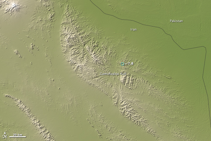
The ongoing collision of two enormous slabs of the Earth’s crust—the Arabian and Eurasian plates—caused a magnitude 7.8 earthquake in southeastern Iran on April 16, 2013. The quake was the largest to hit Iran in more than 50 years. Its epicenter was about 83 kilometers (52 miles) east of Khash, a city with a population of more than 70,000.
Earth’s crust is broken into giant plates that cover the surface of the planet like pieces of a puzzle. Individual plates constantly collide and grind against one another as they slide on top of a somewhat fluid layer of the Earth’s interior known as the asthenosphere, causing earthquakes in the process.
The Arabian plate is sliding north-northeast at a speed of about 37 millimeters (1.5 inches) per year relative to the larger Eurasian plate. Where the two plates collide in an area known as the Makran subduction zone, the Arabian plate plunges beneath the larger Eurasian plate. As it descends into the mantle where it will eventually melt, earthquakes occur deep beneath the surface, along the boundary between the two plates.
According to the U.S. Geological Survey, the earthquake was the result of faulting at an intermediate depth in the Arabian plate lithosphere, approximately 80 kilometers (50 miles) beneath Earth’s surface. The descending Arabian plate has caused quakes as deep as 160 kilometers (100 miles) beneath the surface in this area in the past, though most have been at much shallower depths.
This image, based on elevation data acquired by the Advanced Spaceborne Thermal Emission and Reflection Radiometer (ASTER) on NASA’s Terra satellite, shows the area where the earthquake occurred. Land is shown with shades of green and beige. Higher elevations are lighter in color.
Taken from NASA Earth Observatory Reports
10/2013:
Posted on Monday 15th April 11.50 pm IST
Winter Storm Xerxes: "X" Marks the Northern Plains..Jon Erdman (Weatherunderground)
Xerxes has brought record-breaking snowfall to the Northern Plains.
And lest you think we are using that term lightly, this time we are talking about some serious snowfall records, particularly in Bismarck, N.D.:
Snowiest April day on record: 17.3 inches Sunday broke the record of 15.2" from April 5, 1997.
Snowiest month of April on record: 21.2 inches so far through April 14, breaking the record of 18.7" in April 1984.
Snowiest calendar day, any time of year, in Bismarck history: 17.3 inches Sunday broke the record of 15.5" on March 3, 1966.
Warning for Monday:
Snow in the eastern half of North Dakota and northern Minnesota will gradually wind down through the day. Accumulations should end by sunset but a few light snow showers or flurries may persist into Monday night.
Gusty north to northwest winds will persist over North Dakota and South Dakota, leading to areas of blowing and drifting snow, continuing to make travel very difficult in areas where new snow has fallen. Winds will subside tonight....
9/2013:
Sharp Line in the Clouds

Fast-moving, cool air masses often sweep from east to west across North Africa in the winter, sending surges of dry air over the Atlantic Ocean. When this dry air encounters moister and more stable air masses over the water, the clash can yield distinctive and beautiful patterns in the clouds.
On February 18, 2013, the Moderate Resolution Imaging Spectroradiometer (MODIS) on NASA’s Terra satellite captured this view of a thin layer of marine stratocumulus clouds off the coast of western Africa.
The air mass moving west pushed a wave of cool, dry air ahead of it, much like the bow wave of water that moves ahead of a boat in calm water. When that wave of air met the mass of moist air over the ocean, it pushed the moist air up. As that air rose, it cooled at the peak of the wave, forming a linear wave cloud. As the wave propagated forward, it rose to a slightly lower peak, and so on and so forth, until it eventually dissipated. The series of clouds that formed at the high-altitude peaks produced the rippling pattern seen in the clouds. This type of atmospheric disturbance is known as an undular bore. The air to the east of the bore is almost completely cloud-free because dry air would have eroded any clouds in that area.
The Cape Verde islands had their own noticeable effect on the clouds to the south. Air masses passing over the volcanic islands split into streams, then come back together—a process that creates off-centered areas of low pressure like whirlpools. These low-pressure areas produce thread-like swirls in the clouds downstream of the islands. These are known as Von Karman vortices. The cloud layer is fairly thin in this image, so the vortices are less distinct than they are in other satellite images of the phenomenon.
References
- CIMSS Satellite Blog (2011, April 27)
- NASA GES DISC (n.d.)
- NASA (2007, Oct. 11)
- Washington Post
NASA image by Jeff Schmaltz, LANCE/EOSDIS MODIS Rapid Response. Caption by Adam Voiland, with information from Scott Bachmeier.
x-------------------------------------x------------------------------------------------x-----------------------------------x------------------x------------------------------------------------x---------------------------------------x----------x
8/2013: Latest Updates on U.S. Monster Storm from Mark Vogan and Others:


Two storms have joined forces to bring a major blizzard to New England Friday night into Saturday.The heaviest snow started spreading into Long Island and southeastern New England on Friday evening as the storm ramped up off of the Northeast coast.
-Blizzard currently just east of New England. Pressure of 979 mb similar to a category 1 hurricane. (accuweather)
-Nemo is officially a blizzard - NWS has declared that Portsmouth, NH has satisfied all the criteria (35+ mph winds, 1/4mi vis. for 3 hrs).
-Nemo deepens.. so onshore push of moisture increases & colder air gets ingested = increases convection/snow rates!
-Staffordsville, CT has seen a as much as 6 inches in 1-HOUR! just mentioned on TWC by @parkertwc
-HURRICANE-FORCE: A gust to 76 mph was recorded recently at Boston's Logan Airport!
191,000 customers currently without power in Mass.; 122,000 in R.I.; 34,000 in Connecticut. #nemo
-Islip on Long Island has seen 5" of snow in only 2 HOURS. 3" in just the past hour with thunder and lightning according to @GregPostel
7/2013: Snow Covers most of Britain..all from London to Scotland...superb sat image...
Image of end January 2013

6/2013:"Oswald" Brings Heavy Rains to Northern Australia
A moderate tropical cyclone, Oswald landed from the Gulf of Carpentaria early Tuesday morning, local time, near Kowanyama, spreading torrential rain over much of Cape York.
The first heavy bout of monsoon rain has pelted northern Queensland, from Tropical Cyclone Oswald.
Gusts as high as 100 km/h buffeted Weipa, and rainfall since Sunday was about 390 mms.
Meanwhile, torrential rain struck near Cairns, in the northeast of Queensland, triggering flooding south of the city. Since Sunday, rainfall of at least 300 mms was widespread in the area, the Australian Bureau of Meteorology (BoM) website showed. Bulgan Creek collected 614 mms.
Another Cyclone, "Peta" has formed just off the Pilbara coast. Gales with gusts to 100 kilometres per hour are expected between Karratha and Port Hedland today as Peta moves towards the coast. Gales may extend towards Mardie this evening if the system moves further to the west.


The MSLP charts show the scene, and ITCZ running South of 10S..Normal for this time of the Year...

xxxxxxxx-------------------------------xxxxxxxxxxxxxx--------------------------------xxxxxxxxxxxx---------------xxxxxxxxxxxxxxx--------------------------------xxxxxxxxxxxx
5/2013: Snowy UK Facing a Cold Week
]
Visible satellite shot, taken Monday, Jan. 21, shows widespread clouds, some bearing snow, spread over the U.K. Cold wind flow from the east and southeast is hinted by the cloud patterns. Thick snow cover is seen over southwestern Norway, at the upper right of the image. (Image credit: U.K. Met Office)

Storms Thursday through Sunday 20th Jan left most of England along with much of Wales, Scotland and Northern Ireland mantled in up to 30 cm (12 inches) of snow. At least 3-5 cm (about 1-2 inches) of snow whitened greater London, for instance.
Official warnings for new snowfall and icy roads were spread over the U.K. on Monday, according to the nation's Met Office website. Heaviest snowfall was forecast for the highlands of Scotland and northern England.
Monday 21st, hundreds of schools across the U.K. were shut, owing to snow-covered and icy roads, the BBC News website said.
As of Monday 21st, the highest snow depth observed in the U.K. and Northern Ireland was 19 cm (7.5 inches), metered at both Albemarle, Northumberland, England, and Lough Fea, Northern Ireland. Depths of 18 cm were measured at Sennybridge, Wales, and Redesdale Camp, Northumberland.
In Greater London, depths were 5 cm (2 inches) at both Heathrow and Northolt.


Lowest in UK on Tuesday 22nd:
Andrewsfield -11c, London Stansted AP -10c, Gatwick AP -7c,
Much of Europe is also covered by snow....and UK.....Fully covered

Lowest in Europe on Tuesday 22nd:
Nazimovo (Russia) -41c, Summit Camp Greenland -39c, and Folldal Fredheim in mainland Europe (Norway) -35c.
x------------------------------------------x-------------------------------------------x-------------------------x----------------------------x------------------------------------------x-------------------------------------------x---------------------x
4/2013: We have been reading about the Extreme cold etc..now for some Heat..extreme Heat !!
Severe Heat Wave Down Under in Australia !!

A massive heat wave burning much of Australia has sent temperatures and fire danger soaring.
9th Jan 2013, highest temperatures of up to 49c, or 120 F, were to be found over the hinterland of Western Australia, the nation's huge western state, but with readings still well above 40c (104 F) spread over much of the eastern state of Queensland.
Some of the Severe Highest Day Temperatures on: 5th January: Lihou Reef National Nature Reserve 49c,
6th January: Moomba 47c,
7th January: Port Austa 47c,
8th January 47c at Leonora and
3/2013: Snow in London..and Freezing Fog in U.K.
"Good morning, After a bitterly cold night, you won't be surprised to hear that today may well be staying cold. There are some freezing fog patches around this morning, especially over the Midlands and eastern England. These are going to be reluctant to clear away from some places, and where they do last temperatures will be well below freezing throughout."
The Lowest in U.K. on Wednesday 16th morning was -13c at Aboyne, Marham -12c, Norwich Weather Center -11c, Manchester -6c, Birmingham -5c, Glasgow and Gatwick AP -4c, London Heathrow -3c.The Maximum in London on 15th Tuesday was 3c.
Read also Jim's veiws and report here and Europe report here.
x--------------------------------------------x-------------------------------------------x-------------------------------------------x
2/2013: 9th Jan 2013 48.8c at Leonora an all time high record.
Hobart too broke its highest record when it measured 41.8c.
In Western Australia, readings on 9th Jan 2013 topped nearly as high as the vast state's all-time maximum temperature of 49.8c, or 121.6 degrees F.
The hottest spot, was Red Rocks Point, which soared to 48.6c, or 119.5 degrees F. Red Rocks is located in the southeast of the state, right along the chilly waters of the Great Australian Bight.
Next in line was Eucla, which also lies near the Bight, barely inside the border with South Australia. Eucla reached 48.2c, or nearly 119 F.
In neighboring South Australia, Nullarbor registered 46.8c, or 116.2 F, on 10th Jan.
Deep within the Nullarbor Plain, Forrest registered a sizzling 47.9c, or 118.2 degrees F.
Interestingly, Forrest shares the Western Australia all-time highest temperature of 49.8c -- 121.6 F -- which was reached on Jan. 13, 1979, according to the Australian Bureau of Meteorology (BoM) website. Also in 1979, but on Jan. 3, Mundrabilla Station topped at 49.8c.
The highest temperature ever recorded in more than 150 years of weather history in Sydney is 45.3c (113.5 degrees F), the Australian Bureau of Meteorology (BoM) website showed. For the airport, the historical top is 45.2c. This year it has topped 42c.
7th January, 2013, Hottest Day in History for Australia
Heat-weary Australia has registered its hottest day, on Monday 7th January, 2013, meteorological readings have shown.
Monday 7th Jan, was called the "hottest day on record" after the Australian Bureau of Meteorology (BoM) calculated a national average high temperature of 40.33c (104.6 degrees F), the Australian ABC News website said.
The single average temperature was compiled from between 700 and 800 daily readings spread across the country, the BoM's Dr. Donald Jones said.
The former record high, set in 1972, was part of a comprehensive Australian weather record that dates back to the start of 1911.
(Inputs from Jim Andrews (Accuweather) and Austrailia Met Bur).
First Time a New Colour added !
The giant and record heatwave in Australia has forced the meteorologists to further add 2 new colours, upwards of 45c and 50c in its temperature charts...they have now added, at least till the heat is on..deep purple and pink as the 2 new colours...
This is probably the first time any country has added and re-drawn their temperature charts to take into account temperatures likely to tip and go off the scale hitherto applied and made...Says Bob Ward, of Grantham Institute for Climate Change, London, "Its a measure of the severity of the heat wave...that the National Bureau is struggling to re-calibrate its montoring methods by adding 4c and 2 colours to its scale.."
1/2013:Besides Sub-Continent, let us see the cold elswhere....
Lowest Maximum Temperatures today, 10th Jan 2013:
Asia: Oymyakon: -51c, Verkhoyansk: -50c. ...(Brrrrr)
Europe: Pajala (sweden) -19c,
North America: Rankin AP (Nunavat): -40c.
--Greece: Heavy snow batters parts of Greece (By Robert..IAN)
Heavy snowfall, strong torrential rains, sub-zero temperatures and gale-force winds battered parts of the mainland and the Aegean Sea islands in Greece on Wednesday 9th Jan, for a third day, disrupting land and sea transport.
Several mountainous areas in northern and central provinces, some suburbs of the Greek capital, as well as the southern island of Crete, have been most affected with blocked motorways even for vehicles with snow chains.
The thermometer plunged to -11 Celsius in the northern city of Nevrokopi.
Heavy snow in Athens closes roads and schools, as temperatures dropped to the 0-Celsius mark.
--Record snow in Lebanon..(Thanks to Clay Olson and Argiris Diamantis)
The fiercest winter storm to hit the Mideast in years brought a rare foot of snow to Jordan on Wednesday.
In Israel, snow fell outside Jerusalem and in the northern Golan Heights, according to the Jerusalem Post. Three feet of snow fell on Mount Hermon and flakes were falling in Nazareth as well as in the Galilee. Several roads were closed in the north of Israel due to unusual heavy snowfall.
The unusually heavy snowfall blocked streets in the capital Amman
--This image from the Rutgers Snow Lab shows that there was so much snow in the Northern Hemisphere that it broke a December record.

x-----------------------------------------x----------------------------------------x--------------------------------------x
International Weather Events Summary for 2012.
January:
-Southern Thailand has been hit with damaging floods following extreme rainfall topping 20 inches within two days. Meteorological data showed rainfall of 25.6in within 72 hours at Nakhon Si Thammarat.
-A blizzard that has dumped more than 50cm of snow continues to unleash its fury on southeastern Europe. The worst of the blizzard was bearing down on Bulgaria and southeastern Romania.Accumulation had amounted to 25 inches in the Romanian city of Craiova. Other snow totals in Romania include 10 inches at Sibiu and a fresh 8 inches at Bucharest. In neighboring Bulgaria, 17 inches buried Vratza with 14 inches measured in Pleven.
-It's been an unbelievable winter for many in Alaska. After reaching into the -40F and -50F territory several times this winter across the central and northern part of state, satellite and even an amateur weather station recorded the peak of the cold over the weekend as temperatures dropped to -70F outside of Fairbanks.
February:
-Europe's cold snap has claimed 164 lives.In Poland as the mercury dropped to -32C in some parts, in Ukraine temperatures fell to minus -33C in the Carpathians and -27C in the capital Kiev.In Estonia,temperatures plunged to -30C.
-Several European countries recorded their coldest night of the winter on 2/3 February. These include Sweden, where the temperature in Kvikkjokk in the northern part of Sweden fell to -42.7C which is the lowest temperature in Sweden since 2001 In the capital Stockholm, it was about -14C. It was also the coldest night of the winter in Poland. It was almost -20C, and in the coldest parts in the eastern Poland was almost -30C. Night-time temperatures in Belgium fell to -9C at the coast and -17C on the coldest heights. The normal minimum temperature for this time of year is + 0.4C. In Germany, temperatures fell to -26.4C in Deutschneudorf. The lowest temperature was -11.3C in Powys, Wales. The Siberian air mass reached Portugal which had its coldest night in the last 10 years.
-Frigid air gripping Europe has set the stage for rare snowfall in Rome. One of the major European cities up next to see snow is London. Snow began mixing with rain in Rome during the early morning hours of Friday. Steadier snow followed during the midday and afternoon hours, especially across northern areas. The heavy rate of the snowfall held visibility at or below a half of a mile throughout much of the afternoon hours at the Urbe Airport on the city's northeastern side. Snow is definitely rare in Rome, where afternoon high temperatures typically warm to 12C at this time of year.
-6th: Snow made a rare appearance in Algiers, the capital city of Algeria. Cold air associated with a storm system diving into northern Africa provided for some decent accumulations of snow in the north African country. Reports say the last time Algiers saw this kind of accumulation was in 2005.
-In the last few days of January and at the beginning of February, further extremely cold continental air from Russia arrived and brought ongoing frost to eastern, southeastern, central and large parts of western Europe. Minimum temperatures in Moscow went down to -25C until the beginning of February. Some east European countries (Latvia, Belarus, northeastern Poland, Ukraine) experienced minimum temperatures of around -30C, northern Russia down to -37C. In eastern Germany, minimum temperatures below -20C were measured in many places, in wester n central Europe around -10C to -15C or below (e.g. Luxembourg -13C on 3 February, Strasbourg in France at the Rhine river -15C on 5 February, Basel in Switzerland -17C on 6 February). However, all these minimum temperatures were not new records. The long duration of the cold period, its relatively late onset and the extent of the cold area are noteworthy but not exceptional.
-7th: Snow has blanketed parts of Libya, including the town of Gharyan which is southwest of the capital Tripoli. Snowfall is a rare occurrence in the country.
8th: Temperatures in England plummeted overnight but failed to match the coldest night of the winter so far. Forecasters say the lowest temperatures reached -11.8C in Church Fenton in North Yorkshire. However, this failed to beat the -12.4C recorded at South Newington in Oxfordshire on the night of 3 February. Snow flurries fell overnight around Kent, Sussex and the Thames estuary. Northern Ireland and parts of the north of Scotland remained frost-free. The lowest temperature ever recorded in England during February was -20.6C on 25 February 1947 in Woburn.
March:
-12th: Perth's summer of 2011-2012 has landed in the record books, following a historical first eighth heat wave. The record-breaking hot blast began Friday, culminating in Sunday's high of 41.4C. Monday's high of 40.6C extended March's second major heat wave to a fourth day. A heat wave is defined by the Australian Bureau of Meteorology (BoM) as three-straight days of 35C.
April:
-14th: Tornadic thunderstorms ravaged parts of the Plains (USA) killing six people and leaving behind incredible destruction. According to the Storm Prediction Center, over 100 tornadoes were reported from Oklahoma through Kansas, Nebraska and southern Iowa on Saturday.Some hail reports from this tornados:
Hen egg-sized hail damaged a law enforcement vehicle near Spalding, Neb., around midday Saturday.
Three-inch diameter hail was reported near Petersburg, Neb., early Saturday afternoon.
Quarter-sized hail covered the ground near Ringgold, Neb., Saturday afternoon.
Two to three inches of hail accumulated near Stapleton, Neb., Saturday afternoon.
Hail two and a half inches in diameter was reported in North Platte, Neb., Saturday evening.
Baseball-sized hail was reported just east of Dodge City, Kan., Saturday night.
Tennis ball-sized hail was reported near Greensburg, Kan., Saturday night.
A 97-mph wind gust was reported at the Oskaloosa Airport in Iowa Saturday night.
May:
-25th: After a cool start, around the 20th the UK's weather changed - giving way to a run of dry and fine weather, with some remarkably high temperatures. This included a new maximum May temperature for Scotland - with 29.3C recorded in Achnagart, Highlands, on 25 May, beating the previous record of 29C set in 1992 at Edinburgh Royal Botanic Garden, according to the Met Office.
-29th: The record books for Greenland's climate were re-written when the mercury hit 24.8Cat Narsarsuaq, Greenland, on the southern coast. According to weather records researcher Maximiliano Herrera, this is the hottest temperature on record in Greenland for May, and is just 0.7 degC below the hottest temperature ever measured in Greenland. The previous May record was 22.4C at Kangerlussuaq (called Sondre Stormfjord in Danish) on 31 May 1991. The 25.2C at Narsarsuaq on 22 June 1957 is the only June temperature measured in Greenland warmer than today's reading. The all-time warmest temperature record for Greenland is 25.5C set on 26 July 1990.
June:
-3rd: Stockholm registered its coldest June weekend in 84 years, with temperatures hitting a maximum of just 6C. On Saturday, as blustery winds and heavy rain fell on the capital, "Stockholm reported a high of just six degrees. We have not seen such a low June temperature since 1928," the Swedish Meteorological and Hydrological Institute wrote in a statement.
August:
-10th: A rare fall of snow came to parts of South Africa. Pretoria, South Africa's capital, and Johannesburg were among the cities whitened by snow. While snow is not observed every winter in the city of Johannesburg, it does occur every five years or so.
-11th-13th: The combination of tropical moisture from the south and a frontal boundary arriving from the north led to torrential rainfall across Taiwan. According to observations from the Central Weather Bureau, the heaviest rainfall during 24 hours was in Kaohsiung City where 582 mm fell. Meanwhile, since the rainfall began 1495 mm has fallen over the same area.
September:
-13th: A World Meteorological Organization panel has concluded that the all-time heat record held for exactly 90 years by El Azizia in Libya is invalid because of an error in recording the temperature. The announcement follows a danger-fraught investigation during the 2011 Libyan revolution. Death Valley National Park in California, USA, now officially holds the title of the world’s hottest place - as symbolic for meteorologists as Mt. Everest is for geographers. During 2010-2011, a WMO Commission of Climatology special international panel of experts conducted an in-depth investigation of the long-held world-record temperature extreme of 58C (136.4F). That temperature (often cited by numerous sources as the highest surface temperature for the planet) was recorded at El Azizia, approximately 40 kilometres south-southwest of Tripoli on 13 September 1922. The investigation was conducted with the support of the Libyan National Meteorological Centre for the WMO Commission of Climatology World Archive of Weather and Climate Extremes (http://wmo.asu.edu/), the official WMO world meteorology-verified record of weather and climate extremes.
-18th: This month, Russia's Vostok station has registered some remarkably low late-winter temperatures, even for the coldest known spot on Earth. As of today, the average temperature for the month so far was -73.0C, or -6.7 degC below normal. Three nights have have seen the temperature break through the -80C mark. Coldest of these, on Sept. 15, bottomed at -84.2C. The station's lowest September temperature on record is -85.6C, the Vostok
October:
-18th: The UK has just experienced its "weirdest" weather on record, scientists have confirmed. The driest spring for over a century gave way to the wettest recorded April to June in a dramatic turnaround never documented before. The scientists said there was no evidence of a link to manmade climate change. But they say we must now plan for periodic swings of drought conditions and flooding. The warning came from the Environment Agency, Met Office and Centre for Ecology & Hydrology (CEH) at a joint briefing in London. Terry Marsh from the CEH said there was no close modern precedent for the extraordinary switch in river flows. The nearest comparison was 1903 but this year was, he said, truly remarkable. What was also remarkable - and also fortunate - was that more people did not suffer from flooding. Indeed, one major message of the briefing was that society has been steadily increasing its resilience to floods.
November:
-29th: Parts of eastern Australia are sweltering as heatwave conditions take hold. In Mildura, the temperature is expected to hit 44 degrees today, with 43 expected in Swan Hill and Nhill, 42 in Horsham, 41 in Echuca and 40 in many other cities and towns, including Bendigo, Shepparton, Warrnambool and Rutherglen. A reading of 114.4F at Ouyen set a new high November temperature record for the state of Victoria. The standing state record of 45.0C was set in the early 1900s.
-29th: Moscow was hit by more than 20 cm of snowfall.
December:
-The end of the 2012 hurricane season left an impression, as historic Sandy wreaked immense damage in the Northeast.In 2012 the peak hurricane intensity was as follows:
Category 5 = 0
Category 4 = 0
Category 3 = 1
Category 2 = 3
Category 1 = 6
Tropical storm = 9
-6th: Freezing temperatures have hit much of Scotland and the rest of the UK, shutting schools and causing transport problems on rail networks. More than 50 schools have been affected by snow and ice in the north-east. Two schools in Aberdeenshire were closed and 50 more either closed to pupils having to travel or changed the usual transport routes. Temperatures plummeted on Wednesday night, dropping to -12.9C at Braemar, for example, and to -8.7C at Benson.
6th: Powerful Typhoon Bopha has torn its way through the southern Philippines with winds as high as 130 mph at landfall.
-11th: Snow has also fallen as low as sea level in western and northern Japan, as the first widespread "sea-effect" snows hit the country. By Tuesday, Sapporo had built up a 27 cm snow cover. Also in Hokkaido, but inland, Asahikawa has had as much as 50 cm of snow cover since late last week. The cold has been significant. Seoul, South Korea, has been an average of 5.3 degC colder than normal for the first 10 days of December. Average temperature in Beijing, China, has been 3.1 degC below normal.
This is compiled by the author from various e mails and spinets collected and sent via Brugge. There are many events which are missed out or not published here...
xx------------------------------------x---------------------------------------x---------------------------x--------------------x--------------------------------------x------------------------------------xx
Posted 17th December:
A “cold snap” has walloped much of Iran with heavy snow, leading to the temporary closure of a large section of intercity roads and schools.
The cold weather has dropped as much as one meter (more than 3 feet) of snow in the mountains, and sizable inches in big cities and towns such as Tehran.
Tehran had a high of 6.8c today and the low was 0.4 mms.
Chabahr Port , just near the Pak border, had a heavy rainfall of 230 mms in the 24 hrs ended today evening (Monday).

A general view of a street in Tehran, Iran, 16 December 2012, while heavy snowfall once again paralysed parts of the Iranian capital. EPA/ABEDIN TAHERKENAREH
x------------------------x---------------------------------x-------------------------------x--------x
Posted 21st November:
An Interesting and worth learning Phenomena in Meteorolgy..Cloud Streets:

On November 13, 2012, the Moderate Resolution Imaging Spectroradiometer (MODIS) on NASA’s Terra satellite captured this view of cloud streets amidst northwesterly winds over Hudson Bay.
Cloud streets—long parallel bands of cumulus clouds—form when cold air blows over warmer waters, while a warmer air layer (or temperature inversion) rests over the top of both. The comparatively warm water gives up heat and moisture to the cold air above, and columns of heated air called thermals naturally rise through the atmosphere.
The temperature inversion acts like a lid. When the rising thermals hit it, they roll over and loop back on themselves, creating parallel cylinders of rotating air. As this happens, the moisture in the warm air cools and condenses into flat-bottomed, fluffy-topped cumulus clouds that line up parallel to the prevailing wind.
Cloud streets can stretch for hundreds of kilometers if the land or water surface underneath is uniform. Sea surface temperature need to be at least 21°C to 22°C degrees (39°F to 41°F) warmer than the air for cloud streets to form.
Posted 26th October:
"Frankenstorm" may move up the East Coast of U.S.

Hurricane Sandy made landfall on Cuba early Thursday Oct. 25, 2012 as strong Category 2. Credit: NOAA/National Hurricane Center
Meteorologists keeping an eye on Hurricane Sandy say the storm threatens to move up along the east coast of the United States and could mix with a wintery storm coming from the west to form a monster storm that has been informally dubbed “Frankenstorm.” The hurricane could reach the US coast by this weekend and when the two storms collide, it could continue to pound the eastern seaboard well into the week of Halloween.
Posted on 23rd September 2012:
Fog is simply a fact of life for San Franciscans, particularly those who live near the Golden Gate Bridge.
The Advanced Land Imager (ALI) on NASA’s Earth Observing-1 (EO-1) satellite acquired this view of fog encroaching on the city on August 16, 2012.

The fog is part of the marine layer, a mass of cool, dense air from the sea that was sandwiched beneath a layer of warmer air as part of a temperature inversion. Fog is often present in the lower part of the marine layer, whereas wispy stratus clouds form in the upper part.
Intrusions by the marine layer—and all of the accompanying fog and clouds—are routine in San Francisco during the summer. The intrusions are caused by westerly breezes that push cold air inland to replace the warm air rising off of California’s Central Valley. As it did on the day this image was taken, the marine layer often completely envelops the Golden Gate Bridge in a thick cloak of fog and clouds. (The bridge visible in the lower part of the image is the Bay Bridge; to the north is the Richmond-San Rafael Bridge.)
Below are pics clicked by me during my visit to San Francisco (May 2012)..it was a beautiful site, cannot describe it thru pics..1st picure is the fog setting in , by advection, and gradually thickening...the breeze bringing in the fog was at 16c, while the prevailing temp just 5 minutes before this advent was 25c !
.JPG)


.JPG)
.JPG)
The reflection on the windows of the building shows a superb effect....and this video below taken during the fog event...a treat for any metman !
x---------------------------x----------------------------------x-------------------------------x----------x
Posted on 17th September 2012
Recent Heavy Rains in Sindh...an overview...


These images compare conditions along the Indus River where the borders of Punjab, Balochistan, and Sindh meet. India border is to the right.
Acquired by the Moderate Resolution Imaging Spectroradiometer (MODIS) on NASA’s Terra satellite.
The top image shows flooded conditions on September 13, 2012, and the bottom image shows more normal conditions on September 1, 2012.
Both of these images use a combination of visible and infrared light to increase contrast between water and land.
Water varies in color from electric blue to navy, with darker shades generally indicating deeper water. Vegetation is bright green, and bare ground is pinkish beige. Clouds are pale blue-green and cast shadows onto the landscape below.
x---------------------------------x---------------------------------x-------------------------------x------x
Posted on 14th August...

An Unusual Storm over the Artic Ocean...Today's TOI mentions of Artic Ice breaking off from main chunk...due to "you know what"...But now we now the real reason...

An unusually strong storm formed off the coast of Alaska on August 5, 2012, and tracked into the center of the Arctic Ocean, where it lingered for several days. The Moderate Resolution Imaging Spectroradiometer (MODIS) aboard the Aqua satellite captured this natural-color image on August 7, 2012. The center of the storm was located in the middle of the Arctic Ocean at the time.
The storm had an unusually low central pressure area. “It’s an uncommon event, especially because it’s occurring in the summer,” said Paul Newman, chief scientist for atmospheric sciences at NASA’s Goddard Space Flight Center. “Polar lows are more usual in the winter.” Newman estimated that there have only been about eight storms of similar strength during the month of August over the past 34 years of satellite records.
“It seems that this storm has detached a large chunk of ice from the main sea ice pack,” said Claire Parkinson, a climate scientist at NASA Goddard who studies ice. “This could lead to a more serious decay of the summertime ice cover than would have been the case otherwise, even perhaps leading to a new Arctic sea ice minimum.”
Arctic storms can have a large impact on sea ice, causing it to melt rapidly. Storms can tear off large swaths of ice and push them to warmer sites; they can churn the ice and make it slushier; or they can pull warmer waters up from the depths of the Arctic Ocean.
NASA image by Jeff Schmaltz, LANCE/EOSDIS Rapid Response.
x-----------------------------------x-------------------------------x--------------------------------x-----x
Posted on 7th June:
Which are the Hottest Places on Earth ??
See Video here:
Some places around the world have seen the hottest of summers. Sevilla, Spain has seen temperatures of 122 F (50 C) and Oodnadatta, Australia reached 123.3 F (50.72 C). Another place in Israel called Tirat Zvi recorded temperatures of 129 F/53.9 C.
Rub’ Al Khali in Oman, Saudi Arabia is also a very hot place; this region is predominantly desert and is highly inhospitable for most vegetation and is sparsely populated. Death Valley, California has also recorded temperatures of 134 F/56.7 C. Death Valley hugs the border of California and Nevada and is home to a lot of vegetation and wildlife endemic to the region.
Al ’Aziziyah located in northwestern Libya is also a very hot place. Unlike many other hot regions this one is densely populated. On the other hand, Dasht-e Lut in Iran is a salt desert, so the temperatures reach a searing 159 F/70.6 C. The salt desert also has regions that are covered with black volcano lava, which caters to more absorption of heat keeping the temperatures soaring at all times. The temperature is so hot rendering the place absolutely inhabitable not allowing any form of life to subsist here.
I did not know about this Place in Iran touching 70c !!
Posted on 29th May:
World's Hottest On Tuesday, 29th May: Sibbi (Pakistan): 49c. Makkah and Jacobabad: 48c.
World's Coldest: May 26th 2012; Vostok Satation, Antartica: Maximum Temperature: -78c. Minimum Temperature -81c!
Posted on 10th May;

Scotland:-No sking in March, But full force in June :..For related articles, See International Page and Mark's Blog.
A cold snap has hit Scottish resorts and it is thought it will stick around for up to another month. This will certainly keep skiers and snowboarders happy until the end of June!
Quote Cairngorms Scottish Ski Manager:
“We did not ski at all in March, which is unheard of, so it has been great to have such good snow cover, albeit late in the season.”
After low snowfall during the winter months, the snow-gods have certainly paid a well earned visit to Scotland. Cairngorm Mountain received lots of snow at the end of April and beginning of May, adding hugely to the snow depths on the upper mountain.
At Cairngorm, it’s currently snowing at all levels drifting above 850m (Thursday 10 May). The forecast is for significant snowfall today and tomorrow with high winds/blizzard conditions expected.
Read Full and detailed Reports from Mark's blog..Incidently as Mark himself resides in Scotland.
Posted on 28th March..

March has meant 7,000 weather records broken in the U.S....detailed link here...
A huge, lingering ridge of high pressure over the eastern half of the United States brought summer-like temperatures to North America in March 2012. The warm weather shattered records across the central and eastern United States and much of Canada.
Records are not only being broken across the country, they're being broken in unusual ways. Chicago, for example, saw temperatures above 26.6°Celsius (80°Fahrenheit) every day between March 14-18, breaking records on all five days.
International Falls, Minn., self-promoted as the "Icebox of the Nation",( which saw -48c last winter), tied or broke daily record highs 12 of 13 days from Mar. 10-22. This includes a 79F-degree reading on March 18, which was the warmest day ever recorded during March in International Falls.
Posted on 26th March @9 am
26th Morning saw Dubai overcast and with overnight rains, Priya sends these pictures. Thanks Priya.


Posted on 19th/20th March:

And Now Heading towards S.Pakistan and Gujarat...


An intense dust storm spanned hundreds of kilometers over Iran, Afghanistan, and Pakistan on March 19, 2012. The dust spread southward over the Gulf of Oman and the Arabian Sea, and swept northeastward along the Afghanistan-Pakistan border.
The Moderate Resolution Imaging Spectroradiometer (MODIS) on NASA’s Terra satellite captured this natural-color image on March 19. Some source points for the storm could be seen in southern Afghanistan, and dust blew from these points in southeast-northeast arcs. Most of the dust plumes in this storm were thick enough to completely hide the land and water surfaces below.
A combination of sand seas and impermanent lakes occur along the borders between Iran, Pakistan, and Afghanistan, and the fine sediments from these features often provide material for dust storms. Winds provide the other necessary ingredient, and hot temperatures can increase the likelihood of dust storms by making air near the ground unstable.
Credit Nasa Earth observatory.
Posted on 4th Feb..
Some"Little Ice Age" Headlines:
-Fresh snowfall blocks Srinagar-Jammu highway: Fresh snowfall across the Kashmir Valley from F-1,on Saturday blocked the Srinagar-Jammu highway and an avalanche warning has been issued for people living in the higher reaches,
-Afghan officials hope to reopen Kabul airport after heavy snowfall
-Rome paralyzed by rare snowfall.The streets of Rome were a rare shade of white Saturday after a snowfall blanketed the Italian capital.

-Severe weather alert for England as heavy snowfalls expected
• Snowfall of up to 15cm and temperatures down to -9CHeavy snowfall is expected across much of Britain, prompting Heathrow to cancel around a third of Sunday's flights.
-Snowfall Collapses Steel Bridge in Nagano, Japan:We’ve heard theories fire can melt steel but can heavy snowfall, “crush” a 95-meter steel bridge.A 95-meter bridge in Nagano, Japan, has collapsed under the weight of up to 3 meters of snow.

-Snowfall and frost were reported in most parts of Greece.
-Bustling İstanbul blanketed with snow.

-More than 220 dead as Europe freezes..read here.
Read Here for More details...
Posted on 3rd Feb:
Europe Latest
European Deep Freeze Reaches New Depths, More Deaths, More Hospital Causes
Europe Coldwave Continues, Major Snowstorm Expected From Italy to Russia,
UK On Alert For First Significant, Disruptive Snow Of 2011-12...
Read and see videos, about latest on Europe's deep freeze on our Partner Blog..Mark's Blog.
Posted on 22nd Jan, @11.50 pm


Snow in the Sahara Desert – Video
Snow fell Tuesday 17th Jan, in the province of Bechar in the Sahara Desert in western Algeria.
Strong wind blew the snow across roads and buildings.
Record cold in Canada, 21 Jan report.
Although Canadians are accustomed to cold winter weather, temperatures below -40c are far from commonplace, says this Danish website.
Hendrickson Creek, Alberta, dropped to -41.4c, a new cold record.
The coldest place in Canada over the past days was Teslin in the Yukon, which dropped to -44.0 degrees. The normal day tempoeratur in Teslin in January is -24c.
x------------------------x------------------------------x------------------------------x----------------x--x
Posted on 17th November 2011
Posted on 6th November:
-30s by day and -40s C by night herald the start of winter across Siberian Russia
The 'Pole of Cold' running 8.6C below normal first 5 days of November
Highs at the remote, landlocked and very frozen northeast Asian outpost of Oymyakon, northeastern Siberia has have colder than normal for the first days 5 days of November 2011.
Each day from Nov 1-5 have failed get above -30C (-22F) and lows each night have dropped below -41C. The coldest high was -33.6C (-28F) and the coldest low was -42.6C (-45F). The same first 5 days of November last year weren't quite as cold with highs in the -20s C and lows in the -30s C, still darn chilly by most peoples standards of course for not for these hardly souls.
Incidentally, the average high for November 1st is -23C and on the 5th -26C. Average low is -30C on the 1st and -32C on the 5th.
Posted on 5th November

Next 'omonous' Pacific storm rolls into West Coast, set to bring heavy mountain snows, severe weather and the coldest air of the season to places
The next system in line over the Pacific is now entering the West Coast and pushing wind, rain and snow across the region.
This system as it dives southeastwards over the West, this will force the coldest air of the season all the way down into Arizona and New Mexico, holding daytime highs in the 60s for such cities as Los Angeles, Las Vegas and Phoenix. Normal highs even at this late stage of the year are usually still in the low 80s in
By Saturday, the colder air will have penetrated into the Four Corners and thus the heavy snow clouds will drop down over the mountains of Arizona and New Mexico as the storm's center pushes east into Colorado. This both deepens the trough over the entire West and draws in the cold, covering all of the West from Pacific to Rockies.
FRIDAY NIGHT-SATURDAY: HEAVY SNOW BREAKS OUT FROM NEW MEXICO TO NORTH DAKOTA
By Saturday, the colder air will have penetrated into the Four Corners and thus the heavy snow clouds will drop down over the mountains of Arizona and New Mexico as the storm's center pushes east into Colorado. This both deepens the trough over the entire West and draws in the cold, covering all of the West from Pacific to Rockies.
FRIDAY NIGHT-SATURDAY: HEAVY SNOW BREAKS OUT FROM NEW MEXICO TO NORTH DAKOTA......from Mark's Blog.
Posted on 2oth September:
Winter Arrives Early In The Alps Following Mediterranean Storm..see International Page
By FERGAL TIERNEY -

A potent storm depression centred over Italy caused extremely strong winds and high seas in the western Mediterranean Monday, and also brought some early snowfall to Alpine regions.
The Sardinian Sea saw the worst of the wind, as a storm force maestrale formed through the strong pressure gradient between the low over Italy and a high pressure area over France. The cruise ship Adventure of the Seas, en route from Valencia to Civitavecchia, recorded sustained winds of up to 49 knots (91 km/h), with waves of up to 9 metres.
In the Tyrennhian Sea, 9-metre waves were also recorded by the another cruise ship, Mariner of the Seas. Not exactly what was advertised in the glossy brochure!
In southern France, Cap Cepet (126 m) recorded 42 knot (78 km/h) sustained winds, with a 67 (124 km/h) knot gust, while gale force winds were recorded in western Sardinia. Palermo, in northwestern Sicilia, recorded 74 mm of rain in just 6 hours as a strong cold front moved through. Further heavy rain was recorded in northeastern Italy, Slovenia and Croatia, with up to 90 mm recorded in many areas.
Snow fell in the Swiss Alps overnight on Sunday to levels unseen for the month of September, Swiss weather agency Meteosuisse reported on Monday.
In the ski resort of St Moritz, in the southeast canton of Grison, a total of 45 centimetres (nearly 18 inches) of snow was recorded on Monday morning... the snow line to 800 metres (2,600 feet).
Several other stations in northern Italy, Switzerland and Austria saw up to 40 cms of snow throughout the day, but all but the highest of these should see some thaw during the next few days as the low moves southeastwards towards the the Balkans region.
must be that “Global Warming”... eh?
Posted on 17th August:
First Snowfall in Wellington, New Zealand in 30 Years...see video here.
South Africa snowfall disrupts traffic..see here.
and check Mark's blog for in depth details of International Weather.
Posted on 14th August:
New Zealand In Grip Of Memorable Icy Blast
July 22 – 25th was previously the coldest snap since 1995, with snowfall causing disruption across the South Island and some parts of the North Island. Today’s snowfall been more widespread, however, and snow was reported down to sea level in the city of Wellington and other parts of the North Island. New Zealand Met Service predict falls of 20 – 35 cm above 300 m in the Wellington area, with lesser falls continuing at lower levels.
A Severe Weather Warning issued Sunday evening stated “An extremely cold southerly outbreak has already brought snow to most of the South Island and southern and central parts of the North Island. Snow is forecast to continue tonight and during Monday, with significant accumulations possible in many places. Further heavy snow is likely on Tuesday.”
Snow reached Wellington at about 3pm, then moved up to Palmerston North and Hawke's Bay.
Sleet and hail started falling about 7.30 between the Taranaki towns of Stratford and Hawera. An hour later heavy hail was falling while lightning strikes lit up the sky. Power was cut to parts of South Taranaki. Christchurch experienced snowfall at about 8.30pm, accompanied by winds gusting up to 48kmh.
In Dunedin, the Octagon was covered in snow, with many roads in the city impassable.
Queenstown recorded the lowest temperature at -2 degrees Celsius. Wellington hovered just below 3C for much of the afternoon and early evening.
MetService described the storm as a once-in-a-lifetime experience that would affect the entire country.
For a live camera feed of Wellington, click here.
and more on Mark's Blog.
Posted on 3rd August:
This Year will continue the Cycle of 'Colder & Snowier Than Normal' Winters for the UK
'The 2011-12 winter may be one of worst overall for UK
HIGHLIGHTS
Extreme Cold Will Be a Regular Visitor with Low Temps of between -16 to -24C possible from Scotland 's far north to the Suburbs of London
Another White Christmas is possible for most of the UK , most likely over Scotland
Cold and Snow to Arrive to much of UK
More details on Mark's Blog.
Posted on 23rd July:
U.S. Heat Wave 2011.
The United States is experiencing a heat wave with unbearable temperatures soaring into the triple digits all across the country.
(All Temperatures in F)
The mercury in Newark, N.J., reached 108, the highest temperature ever recorded in the city. Airports near Washington and Baltimore hit 105. Philadelphia reached 104, Boston 103, Portland, Maine, and Concord, N.H., 101 and Providence, R.I., 100. New York City hit 104 degrees, just 2 short of its all-time high, and with the oppressive humidity, it felt like 113.
And the effects of the Heat ??
In Philadelphia, 50 of the city's 70 pools operated on 45-minute cycles to give everyone a chance to get in.
Some New Yorkers were unable to take a dip to cool off at some beaches in Brooklyn and Staten Island after millions of gallons of raw sewage spilled from a wastewater treatment plant.
In New York, people looking to beat the heat were thwarted by warnings urging them to avoid city waterways after a wastewater treatment plant disabled by fire began spewing millions of gallons of raw sewage into the Hudson River.(It happens in the U.S. too)
Horse races were canceled at several tracks.
Emily Robinson, center, of Madame Tussaud's Wax Museum in the District checks to see if her statues of Thomas Jefferson and Abraham Lincoln are melting as temperatures soar.
While the current heat wave has recorded 12 all-time daily highs so far this month, it has also registered 98 all-time overnight highs, the NOAA reported at a briefing on Thursday.
When it comes to a record high for a particular date, 1,279 locations have tied or broken daytime records this month, while 3,128 night-time highs have been tied or broken.
For example, on Wednesday, Eppley Airfield in Omaha, had an overnight low of 82 degrees.
That was a full 5 degrees warmer than the previous warmest overnight on that date, set in 2002.
Newark, New Jersey sets new temp benchmark of 108°, more All-Time Records will fall, Central Park, NYC currently 104°, Philly 102°, Boston 102° at the moment!
Second hottest night ever (tie) in Washington, D.C. (Click)
Posted on 16th July:

Posted on 8th July 2011
The Atacama Desert Experiences Heavy Snowfall...for those interested on International Page.
see link here.

Posted on 8th May;
Detailed Note sent by Neeraj from Nepal:
We in Nepal think of arrival and departure of monsoon in terms of Nepali calender dates. Generally Asar, Shaun and Bhadau are three monsoon months which translates to June 15 to September 15.The farming community fix the dates for sowing and harvesting according to Nepali calender, so 15 Asar is the day they plant rice (esp in the mountains, in the plains there can be more than one harvest of rice). 15 Asar generally falls on July 1st. It is assumed that by this time enough rain has fallen to make the rice fields muddy enough for the planting.
Monsoon enters the country from the east and progresses towards the west. The amount of rain is generally more in the east than the west. And monsoon lingers for more amount of time in the east.
Geographically Nepal can be broadly divided into three regions progressing from the north to the south. The northernmost region is the high Himalaya. The snow line is at 5000 m. So all the peaks above this would be snow capped throughout the year.As far as I know (heard somewhere), the higher peaks are not affected by the monsoon system that much as the monsoonal flow is below them. In the valleys and lower slopes, there is human habitation, and south facing slopes get ample amount of the rains. The same is not true for the north facing slopes. Places to the north of the main peaks of himalaya are in rain shadow, one example is Jomsom whose average annual rainfall is only 250 mms.
The middle part is what we call the mid-mountains or mid-hills. This is the place where most of the people live. And this places get good rain in the monsoon. As far as travelling in monsoon goes, westerners generally do not travel during the monsoon season. Whenever there is a heavy downpour, we get a lot of landslides and roads could be closed for days. And all the rivers are swollen to their fullest during monsoon and in places where there are no bridges, the crossing gets very tricky. And yes, you don't get to see the view of the Himalayan peaks most of the time as they are covered. Some airports (mostly grass field ones) don't operate during the monsoon.But south asian tourists are not as put off by monsoon as much as the westerners.Many Indians do visit during this time as the climate is considerably cooler in the cities like Kathmandu and Pokhara compared to the Indian cities during the monsoon.
The southernmost part is the Terai plains (These days the word "Madhes" is preferred in the place of "Terai"). Madhes stretches from the east to the west. In the east it boarders West Bengal in India and in the west its Utteranchal. The easternmost town is Kakadvitta whose climate is similar to Siliguri in India. And the westermost town is Mahendranagar whose climate would be similar to maybe Dehradun. Madhes is thin strip of land , at places only 10 Kilometers wide. At others around 25 Kms. And of course, it rains more in the east than the west. It true for all three regions. The climate in Madhes is hot to very hot. Cities like Bhairahawa, Nepalgunj and Dhangadi sometimes see temperature climb above 40 degrees mark. During 2008-2009 I was in Bhairahawa and have experienced upto 42 degrees there. That's the highest I have ever endured (i think!).
As far as the kind of rainfall goes, its generally thunderstorms/
But a lot of things depend on Monsoon over here. I think its the same for all of south asia. One thing we lack these days is electricity. As the demand has gone up exponentially, the supply is short and we get many hours of daily power cuts. And during the monsoon, the situation is much better as all the hydro electric stations are generating at full capacity.
If you are interested in photos, this site has some good ones: http://welcomenepal.com/
promotional/downloads.php?page=photographs
Thanks Neeraj. Our readers would find this quite interesting.
X--------------------------X--------------------------------------X------------------------------------X-----------------------
Posted on 7th May 2011.
Monsoon information on Pakistan:
The South-West Monsoon reaches Pakistan towards the beginning of July and establishes itself by the middle of the month. The strength of the monsoon current increases gradually form June to July; it then remains steady, and starts retreating towards the end of August, though occasionally, it continues to be active even in September.
Southern Pakistan, including Karachi, I feel, basically gets its rainfall when
1. An UAC forming over Central India travels westwards (most of them in July/august)
2. If a system forms in the Arabian Sea, and tracks northwards towards the Pakistan coast (mostly in June).
3. If, we find the axis of the Monsoon trough lingering for a longer period of time with its western end over Upper Sindh region.
The Northernmost regions are not directly "in touch" with the SWM, and actually get their monsoon moisture only when the western end of the monsoon axis shifts to the upper most western regions, adding extra moisture to the Intertropical Convergence Zone (ITCZ), referred to as the monsoon.
It was this phenomena, and the dipping of the westerly jet streams, that bought the flooding to the region on 26th - 31st July last year.See attached Diagram of the period.

Monsoon information on Nepal:
As I know the monsoon season in Nepal is between June and August. The weather is hot and wet at times. It rains almost everyday with occasional thunderstorms in the evening.
I think that the monsoon is one of the very best times to travel in Nepal if you want to see the true culture, way and beauty of life in the Himalaya.
 But, many people get put off travel to Nepal during the monsoon.
 Sure, you probably will not see the coveted snow capped peaks of the Himalayas, but the rewards of getting a bit wet and experiancing the Himalayan thunder is worth it. Its a touch of good humour to sit out the down pours and your camera to capture the heart and soul of Nepal.
The monsoon itself is very much the life blood of both urban and rural Nepal. Life here revolves around the arrival and departure of the annual three month deluge.
In the event of the monsoon trough,along its axis, getting stuck along the Himalayas, there can be very heavy rains along the Terai plains, and most of the river sources get torrential rains leading to flooding.
Rainbow in Kathmandu

These are my personal views and assumptions. For any other purposes please refer to official weather departments.
Posted on 8th. April 2011
TODAY'S WEATHER ACROSS UK & EUROPE
By Mark Vogan
United Kingdom enjoys warmest April 6th on record following driest March in over 50 years!...see details of Mark's Bog on International Page of Vagaries.
Santon Downham, Suffolk reaches 23.9C or 77 degrees F.
It was further west from around Cumbria northwards which began seeing heavy rains which lifted north with the trough eventually coming to a halt over Glasgow and the Scottish Highlands. This deep channel of Atlantic moisture flowed from the warm Azores, straight northeastwards into Dumfries and Galloway area. This channel, which was the seperation boundary between warm sub-tropical air and maritime sub-polar air advanced north as the strong southerlies associated with the ridge warmed the upper levels as it progressed up through England and Wales and even into southeastern and eventually northeastern areas. The geographic block of the Scottish Highlands meant that the Atlantic moisture plume was being wrung out once it got so far up and over the Highlands, meaning Moary, Aberdeenshire and down the Scottish East Coast was fine, dry and enjoying the influence of the warm high. This was allowing temperatures to soar from 18 to 21C or 67-70 degrees F.
With the northward expansition of this high spreading all the way into the UK forcing cloud dissipation and warming, temperatures rose 8 to over 10C above seasonal averages for this early point in the year. Readings as warm as 21 to 22C where common from throughout the Greater London area all the way to Yorkshire in the northeast of England. Even further north, Byvie Castle in Aberdeenshire (NE Scotland) reached 21.1C (70F), These highs are a full 10-12C WARMER THAN NORMAL. It should basically be in the low 50s F, not low to mid-70s F.
A reading at Santon Downham, Suffolk, outside of London reached 23.9C, that's a summer-like 75 degrees F and was an actual fact the warmest UK-wide April 6th high on record...
In today's blog, Mark has also put Spain touching 32c, and the latest U.S. Weather.
Posted on 19th. Feb 2011:
TODAY'S WEATHER ACROSS UK & EUROPE
By Mark Vogan
Higher Routes of Scotland, northern England to see snow, possibly significant accummulations.
Roads include the M74 between Blackwood and Beattock Summit and all Highland routes north of Central Belt
Significant snow is possible over the hills of Scotland and the north of England tonight and into tomorrow as yet another band of heavy rain pushes in off the Atlantic along a frontal boundary. As this large band of rain pushes into colder air that's crossing the North Sea and into the eastern side of the UK, the collision of milder, moist Atlantic air and drier, colder air flowing in off the continent will mean, anywhere over perhaps 500, 1000 ft will see snow and perhaps several inches of accummulation. Higher roads including those in the Highland, just north of the Central Belt, even the Campsie Fells just north of Glasgow as well as the M74 from Blackwood/Lesmahagow southwards and particularly the stretch between Happendon and Abington services as well as over Beattock Summit may see treacherous driving conditions by morning.
This will be whilst the southwest of Britain sees temperatures as warm as 10 or 12C with brisk southeast winds and heavy, persistent rain for a good part of tomorrow morning. Though, the coolest areas will be eastern Britain, especially along the North Sea coast where that raw east wind will whistle in, it's going to feel cold but actual air temps will be above freezing. Cold enough for snow to fall but not particularly nasty as the milder air flowing in from the west will modify the eastward moving colder air.
Posted on 17th. Feb. @ 9.30 pm:

One Cyclone Survives around Australia.
Ex-Cyclone "Carlos", is now a low with central pressure at 993 hpa and core winds at 55 kmph. Expected track is maintained at SW along the Western Australia Coast.
While "Dianne" is now a Cat.2 Cyclone with core pressure falling to 972 hpa and winds increasing to 100 kmph with gusts up to 150 kmph.
Now with the fate of Ex-Carlos clear, an upper air trough will steer "Dianne" southwards over the waters, where SST are at 28c.Most likely it will remain off the coast and track S and become a severe cyclonic storm by Friday.
Peak intensity is expected during Saturday 19th February. Dianne is then expected to gradually weaken over cooler SSTs
Oklahoma is up 113 degrees from 6 days ago as Guymon reaches 82 degrees ...see Mark's Blog for details.
Posted on 16th. Feb @11.30 pm
Australia Threatened again by 2 Cyclones;.

Two cyclones, Carlos and Dianne, are breathing down the Australian Coast line, threateningly.
Carlos, near Darwin, is at 993 hpa core pressure and winds at 65 kmph. Gusts are measured at 95 kmph. It is a Cat.1 cyclone. Expected to move South-East, along the Australian Coast. System has already poured 400 mms in Darwin last 48 hours. Winds are bringing down trees and structures in darwin.
Dianne, also Cat.1, is having core pressure of 986 hpa, and winds as per latest reports, are at 75 kmph with gusts measuring up to 100 kmph.Due to an "uncomfortably" close proximity with "Carlos", "Dianne" is stationary as per latest 6 hrs report.
Next report tomorrow morning (IST).
Posted on 11th. Feb
The following are preliminary record low temperatures set or tied this morning across the southern Plains and Southwest, with the previous record in parenthesis:
Courtesy of AccuWeather.com
--Medicine Lodge, Kan.: -17° F (-15° F, 1899)
--Dodge City, Kan.: -10° F (-5° F, 1885, 1981)
--Ashland, Kan.: -20° F (-3° F, 1982)
--Ness City, Kan.: -18° F (-7° F, 2003)
--Liberal, Kan.: -8° F (-4° F, 1933)
--Bartlesville Airport, Okla.: -28° F (-13° F, 1929)*
--Oklahoma City, Okla.: -5° F (4° F, 1899, 1929)
--McAlester, Okla.: -4° F (10° F, 1981)
--Tulsa, Okla.: -12° F (-3° F, 1929)
--Fayetteville, Ark.: -18° F (3° F, 1981)
--Midland, Texas: 5° F (13° F, 1933)
--Austin - Camp Mabry, Texas: 19° F (21° F, 1929)
--Austin - Bergstrom, Texas: 19° F (23° F, 1973)
--Del Rio, Texas: 23° F (23° F, 1973)
--Alamosa, Colo.: -24° F (-19° F, 2004)
--Cottonwood, Ariz.: 17° F (23° F, 2001)
--Victoria, Texas: 24° F (24° F, 1973)
--Topeka, Kan.: -9° F (-8° F, 1982)
--Abilene, Texas: 11° F (11° F, 1933)
--San Angelo, Texas: 12° F (12° F, 1929)
--Corpus Christi, Texas: 26° F (27° F, 1929)..more details on Our Partner's Blog.
Posted on 10th. Feb:
Last night's (Wednesday, 9th. Feb) snowfall is the latest snow Beijing has had in 60 years, Xinhua News Agency reported.
With an Artic wave approaching Russia, Jim (Accuweather) feels Moscow, St. Petersburg and other major cities of European Russia may have their lowest temperature of the winter thus far.
Moscow has been as cold as -23.6c, on Dec. 1. In St. Petersburg, -23.1c was reached on Jan. 26 and 27. Readings here will retest these levels during the coldest nights.
Normal daily low temperatures for Feb. 9 are -13.9c in Moscow and -12.8c in St. Petersburg.
WEATHER TALK
By Mark Vogan
AMARILLO, TX SUFFERED WINDBLOWN SNOW, AN AIR TEMPERATURE OF -2F AND A WINDCHILL OF -41F THIS MORNING!...check Blog for More.
Posted on 8th. February:
Oklahoma City - More than a Year's Snowfall in One Day:
Also breaks daily snowfall record set in 1913.Oklahoma City averages 8.6 inches of snow each year, so the 11.8 inches of snow on the ground when Tuesday's blizzard finally came to an end was more than it usually receives in an entire year.
It also shattered the daily snowfall record of 5.5 inches set in 1913.
Tuesday's snow is also the most Oklahoma City has ever received on any day in the entire month of February. That record - 6.5 inches - was set on Feb. 7, 1986.
The 3.4 inches of snow in Abilene, Texas, broke Tuesday's snowfall record of 1.9 inches from 1985.
And From Our Partner's Bog:
TODAY'S TOP WEATHER STORIES
On Weather & Climate Through the Eyes of Mark Vogan
AUSTRALIA'S EXTREME SUMMER OF 2011 CONTINUES
from sydney's record heat to melbourne's flooding downpours to perth's devastating wildfires, australia is being circled by extreme, devastating weather, what next?
Asks Mark, and explains in his Blog...
Posted on 7th Feb:
Winter Beginning to fizzle with warm, Atlantic drizzle!
NOVEMBER 20TH, 2010 THROUGH JANUARY 10TH, 2011 SAW WORST OF WINTER AND WORST DISPLAY OF WINTER SINCE THE 1800S, SHOULD BE SMOOTH SAILING ALL THE WAY TO SPRING FROM NOW ON!
Story By Mark Vogan
WEATHER TALK
By Mark Vogan
FOR GLASGOW, SCOTLAND, THIS MONTH MAY BE FIRST ABOVE NORMAL METEOROLOGICAL WINTER MONTH SINCE SEASON 2007-08
THE LAST TIME GLASGOW HAS ENDED A WINTER MONTH (DEC, JAN, FEB) ABOVE THE MONTHLY AVERAGE WAS FEBRUARY 2008 WHICH WAS +2F
Both December, 2010 which averaged an incredible 12 degrees below normal (F) and January, 2011 averaging over 1 below normal (F) and December, January and February last season each ending below normal with the greatest departure being over 6 below normal in December 2009, this month appears the most likely to close above normal for the first time season February 2008 which was the last "warm winter".
It's currently averaging 4 above normal for the first 5 days and with the current pattern looking likely to stick around, it's looking highly likely thatGlasgow
By Mark Vogan
FOR GLASGOW, SCOTLAND, THIS MONTH MAY BE FIRST ABOVE NORMAL METEOROLOGICAL WINTER MONTH SINCE SEASON 2007-08
THE LAST TIME GLASGOW HAS ENDED A WINTER MONTH (DEC, JAN, FEB) ABOVE THE MONTHLY AVERAGE WAS FEBRUARY 2008 WHICH WAS +2F
Both December, 2010 which averaged an incredible 12 degrees below normal (F) and January, 2011 averaging over 1 below normal (F) and December, January and February last season each ending below normal with the greatest departure being over 6 below normal in December 2009, this month appears the most likely to close above normal for the first time season February 2008 which was the last "warm winter".
It's currently averaging 4 above normal for the first 5 days and with the current pattern looking likely to stick around, it's looking highly likely that
Posted on 5th. Feb.
Largest departure from a normal high temperature:..From Mark's Blog...
This might be the largest departure from a normal high temperature I’ve ever seen !!
Chihuahua, Mexico had a high/low of (18F/14F), -7.7c/-10c, on Thursday. The average high/low is 21.6c/5c, (71/40). So the high temperature was 53F, or 29.3c, degrees colder than average!
Saltillo, Mexico had a high/low of (36/19F), 2.2c/-7.2c, on Wed. and (37/13F), 2.6c/-10.5c, on Thu. Their average is (70/50F), 21c/10c. They also reported a trace of snow. Monterrey had a high/low of (45/28F), 7.2c/ -4c, compared to an average of 70/50F), 21c/10c.
More in detail on Mark's Blog...
Posted on 4th. Feb.
From Our Partner Blog....Check an in depth detailed feedback of the Biggest U.S. Snowstorm on Mark's Blog:
Headlines on Mark's Blog..
RECORD-BREAKING SNOWSTORM HARNESSES RECORD COLD ALL THE WAY TO MEXICO!!
-18 AT KENTON, OK, -12 AT KANSAS CITY, -5 AT AMARILLO, TX, -13 AT DALHART, TX, 1 AT EL PASO, TX!
Albuquerque, New Mexico hits -6, Angel Fire, New Mexico -36!
Oklahoma boasts reading as low as -19 with Mesonet, -18 at Kenton and Nowata 'officially', A record -6 at Tulsa
Amarillo, Texas hits -5, Dalhart, Texas plunges to -13... El Paso, Texas dips to 1 degree...
Wednesday was the coldest day in almost 50 years in El Paso, with the temperature only rising to 15 degrees. That temperature broke the all-time record minimum high of 17 degrees from Jan. 10, 1962.
A Record Low of -12 was tied this morning at Kansas City International Airport
Temps dipped to as low as 2 or 3 (-16C) in Mexico
Temps dip to 30 at Phoenix Sky Harbor, -23 at Window Rock, NE Arizona.....check Details Here...
Also..TODAY'S WEATHER ACROSS SCOTLAND & UK
By Mark Vogan
NORTHERN UK WEATHER WARNING
SCOTTISH CENTRAL BELT & NORTHERN IRELAND TO SEE GUSTS OF 50-60MPH, HIGHLANDS AND ISLANDS OF SCOTLAND 70-90PH WITH MOUNTAIN TOPS POTENTIALLY TOPPING 110-120MPH TONIGHT!!!!
Posted on 30th. Jan. 2011:
WEATHER TALK
By Mark Vogan
HAS THE NORTHEASTERN USA BECOME SNOWSTORM ALLEY???
It seems like those nearly snowless winters of 06-07 and 07-08 have become a distant memory as winter's have not only become much snowier than normal but record-breaking snowy across the Northeast!
Why such big snowstorms from Philadelphia to Boston this year and from Richmond, Washington, Baltimore and Philadelphia last year? Well, the track of the low pressure train of course is the number one key as of course you need a storm to track across the Northeast tpo produce the largescale, heavy precipiation but in order for it to be snow rather than rain, the low pressure center must be to the south and east of the I-95 in order for the circulation to pull colder air in from the Ohio Valley and north rather than in off the warm Atlantic.
It appears that when low's develop over the northeast Gulf or at least originate in the warm, sub-tropical waters and then move north, northeast around the base of the eastern N.A trough they draw warmer, sub-tropical properties north into a colder environment. Those winters of 06-07 and 07-08 were warm overall and thus any system trying to enter a relatively warm environment would clearly drop precipitation as rain or freezing rain. The cold in those winters were more centered over the Western US and Interior, not the East.
But last winter and this winter has appeared to see a large increase in both severity of cold that's dropped south from the Arctic as well as coverage over the East and particularly Northeast region.
A COLD OF COLD AIR, FURTHER SOUTH WITH LARGE-SCALE BLOCKING OVER CANADA MEANT TO STORM TRACK FOCUSED ON THE SOUTH AND SOUTHEASTERN US IN 2009-10
Last winter saw a classic El Nino storm track and with a heck of a lot of cold air around over the central and southern US during the core of winter and warmth over Canada thanks to large-scale, powerful blocking high's, the storms roamed the South and Southeast, the track was pushed further south (as expected with an El Nino), meaning the snowstorms (thanks to all the cold air getting far south) meant the snow corridor was focussed from Dallas to DC.
When lows form on the tail or base of the trough and this is positioned over the Gulf Coast region, their forced to ride up the East Coast when the trough axis is centered over the Ohio Valley.
The nature of having a cold continent to the west and warm Ocean to the east, with the low cutting inbetween with it's clockwise circulation, as the system gets to the latitude of the Virginia Capes/Hatteras the shape of the coast means that the low crosses a thermal boundary over the ocean surface which rapidly grows colder as the Gulf Stream which it followed from Florida to Jersey shoots off to the northeast and meets the southward flowing the Cold Labrador current meet, this as well the feel of colder air over the Ohio Valley and Ontario, Quebec means a rapid deepening of the low off New England.
Superstorms such as this winter and last occur when you've still got a warm AMO (Atlantic Multidecadal Oscillation), especially in it's later pahse which many believe it is, means warmer waters push closer to shore and thus waters nearer the Northeast are warmer and with lots of Arctic air overhead, this creates high octane fuel for blossoming Nor'easter's to feed off of.
As the winters grow colder over the Northeast and waters remain warm offshore, this means we appear to be in a stormier, snowier pattern in this part of the world.
Geography and current climatic period (perhaps a transition from warmer to colder times) mean we're in a period of an increase in bigtime, major and crippling snowstorms. This area is of course home to some of the greatest snowstorms on earth and we have certainly seen a tremendous display of nature this year and last.
I do see more big storms during February and even March as colder air continues to feed down the heart of the continent.
For those interested in knowing more of the U.S. Weather, check in on our Partner's Blog with ( more) NYC Storm Videos.
Posted on 20th. Jan:
Cold..Colder...Extreme cold ..N.Hemisphere Freezing all Over !
frigid cold intensifies over north america - 19 Jan 11
This morning: International Falls hits 26 below zero, set to get colder, perhaps 35 to 40 below! Yesterday, Montreal, Quebec hit -11 (-24C)
-Mark's Blog.
Record snowfall in Grande Prairie, Alberta - 18 Jan 11
India - Bitter cold kills more than 200 - 9 Jan 11
Deadly extreme cold - Snow worst in decades in northwest China - 100,000 homes flattened or damaged
Severe winter in Mongolia - 800,000 animals lost- 17 Jan 11
Cold kills 9,248 head of cattle in Vietnam-17 Jan 11
8 new record lows in Florida (7 in the teens in F) - 17 Jan 11
Snow in all 49 States - All but Florida - 12 Jan 11
2-3" snow/hr for Boston (75 mms/hr) - 12 Jan 11.
Heavy Snow/Cold hits Myanmar.
Heavy snowfall in northern Kachin State on Sunday caused the collapse of several buildings
Freezing conditions in high-altitude areas of western, eastern and northern Burma at the end of December have continued into the new year, with Hakha and Mindat townships in Chin State and Loilem and Pinlaung townships in southern Shan State experiencing below-zero temperatures at night.
Posted on 16th. Jan;
It has snowed in every state in the U.S.
Yes, even Hawaii has some snow flakes present on its Mauna Kea volcano, but Florida
According to CNN, “69.4 percent of the lower 48 is covered in the white stuff. Even our fellow Southern states find themselves covered”.
It's like the weather God started shouting, "You get some snow! And you get some snow! And you get some snow! Everybody gets some snow!!!! ...Except forFlorida
According to CNN, “69.4 percent of the lower 48 is covered in the white stuff. Even our fellow Southern states find themselves covered”.
It's like the weather God started shouting, "You get some snow! And you get some snow! And you get some snow! Everybody gets some snow!!!! ...Except for

A similar event happened last year, and was reported in Vagaries. In 2010, Florida 's panhandle saw some snowfall, while Hawaii
Posted on 15th. January:
TODAY'S WEATHER ACROSS SCOTLAND, UK AND EUROPE
By Mark Vogan
Posted on 8th. Jan. 2011
MORE SNOW FALLING TONIGHT ON TOP OF THE INCH WHICH FELL LAST NIGHT, MANY AREAS RECIEVED MORE, ENOUGH TO CLOSE EDINBURGH AIRPORT ONCE AGAIN!...more on Mark’s Blog.
Coldest December EVER In South Florida.Miami's average mean temperature in December was 61.4 degrees, which also breaks the record 62.1 set in 1935.
Up to 16 inches of snow for New York
A cold wave gripping much of South America has caused areas where the average temperature is normally above 20c to fall below 0c. These extreme temperatures claimed dozens of human lives in Argentina , Uruguay and Paraguay Bolivia , officials have announced the death of nearly 6 million fish in the eastern province of Santa Cruz
Posted on 4th. Jan.2011;
Weather Limelight shifting from Frozen Europe to North America as Core of Cold crosses the Pole...
UK, Western Europe suffering from a December-to -Remember Hangover? Will we really warm in January?...
All on Mark's blog.
Posted on 26th. December 2010:
Britain endured its coldest Christmas Day in living memory.
The mercury plummeted to -5.9C at Glenlivet in 1996, but that record was smashed last night when temperatures dropped to -17C at Worcester and -18C at Altnaharra in northern Scotland.
Some areas enjoyed a traditional white Christmas, with snow falling in
Edinburgh, Glasgow, Aberdeen and north east England.
Most parts of England, Wales and Northern Ireland were sunny and dry but daytime temperatures are set to remain below freezing.
More records on Mark's Blog.
Snow In Australia too !!
While the bitter freeze in Europe continues, Australia's usual hot and summery December weather was replaced by snow in parts of New South Wales and Victoria, after plunging temperatures and snow swept across the east of the country.
Australia normally experiences temperatures of 86F (30C) at this time of year,
"About 30cm of snow fell at Perisher in NSW yesterday, while Victoria's Mount Hotham received a 10cm dusting on Sunday.
"Charlotte's Pass in the NSW Snowy Mountains also received a 10cm sprinkling of snow, prompting would-be bushwalkers to don clothing more suitable for skiing.
"It was surprising to see the Kosciuszko Chalet Hotel blanketed with snow at this time of year, resort manager Michelle Lovius told The Australian yesterday.
"When you walk in it, it's up past your ankles and it's just started snowing heavily again.
"Sydney yesterday saw unseasonably low temperatures of just 13C. The western suburb of Horsley Park recorded 9.8C and the Blue Mountains dropped to -2C.
But wait, ten years ago we were told snow was a thing of the past. Oops
Posted on 19th. December:
England hits new low of -19C, on the heels of the coldest day in Northern Ireland since records began
Yesterday saw Northern Ireland endure it's coldest day on record where Castlederg, Co Tyrone only "warmed" to -11C after a low of -14C the previous night
Full details and pics on Mark's Blog.Link on the right of page.
Posted on 18th. December:

Coldest December since records began as temperatures plummet to minus 10C bringing travel chaos across Britain
Severest winter keeping our Partner extremely busy !!
Full write up with pics on the deep freeze in U.K. on Mark's Blog. A very unusual and severe winter grips Britain with the possibility of the recording the coldest ever December since records began !
Posted on 12th. December:
U.S. Winter extreme. Monster Storms:

ONE FOR THE AGES: SEVERE WINTERSTORM STRIKES MIDWEST
MIDWEST BLIZZARD: SOME OF THE WORST CONDITIONS YOU'LL EVER FIND!.......
Pick up the full story from Mark's Blog here.Superb and informative.
Please note, Mark's Link is always put up on the Home Page. Please visit his blog for best U.K. and U.S. weather.
Posted on 11th.December:
Record-setting snowfall brings Paris to a standstill
"French motorists camp out as snow smothers Paris,"
says Reuters
"Stuck", headlines the popular daily Le Parisien
"The great freezing of Paris", said Le Figaro
"Freeze brings Paris to a standstill," heralded SOTT
"Icy roads paralysed much of the Paris region Thursday after the heaviest snow in a quarter of a century.
"French Interior Minister Brice Hortefeux asked drivers not to travel unless absolutely necessary the day after 11 cm (more than four inches) of snow fell on Paris.
"He said around 1,000 motorists had to spend the night snow-bound in their cars.
Thousands spent the night at Charles de Gaulle airport after their flights were cancelled, and thousands of stranded motorists were put up in municipal halls and school sports halls around the Paris region.
In Velizy, southwest of Paris, between 7,000 and 8,000 people spent the night in company offices, at a shopping centre and in a sports hall.
Posted on 3rd. December:
LATEST NEWS FROM ARCTIC BRITAIN
For many, last night beats coldest nights of last winter!
-16C at Aberdeen, -13.7C at Edinburgh, -10C at Glasgow, -15C at Eskdalemuir, -20C at Braemar
A superb narration of the cold in U.K. Very well explained and a detaied report, a must reading for all weather enthusiasts.
Story by Mark Vogan. Please read on in our partner Mark's blog.


2 comments:
When I was in Uruguay, it rained really hard. It was crazy!!! I could not believe my eyes when this happened, I mean, we are on the 21st Century in a big city like Montevideo and these things still take place. Everything became flooded. Water got inside buildings. I had never seen anything like this. I felt much safer when I went to Argentina. I stayed in several buenos aires apartments and when it rained nothing happened, no floods. Global warming has a lot to do, but cities have to prevent what is going to happen and do something about it, like the government of Buenos Aires. Now hey have no problems when there is a storm!
Carla: Thanks for your views. And it seems you are from Argentina. When was this heavy rains in Uruguay ? Flooding is common in Big cities...
Post a Comment