Posted 11th May 3 pm IST....Development in Arabian Sea
A detailed analysis of the meteorological situation in the Sea.
System will intensify to cyclone stage finally.
Currently it may move North- North West skirting the West Coast of India. 
Below Analysis by Vineet ( Vagaries Team)
Possibility of cyclone formation in the southeast Arabian Sea and the prevailing ocean conditions in the south Arabian Sea.
By Vineet Kumar Singh (Vagarian and Researcher at IITM)
As on 11 May 2021, the genesis of cyclone in the southeast Arabian Sea likely to be on 14 May 2021 (Figure 1a) with intensification to cyclone category likely on 15 May 2021. As per IMD-GFS cyclone can be very close to Kerala coast on 15 may 2021 (Figure 1b).
Ocean conditions continue to remain extremely favorable for cyclone intensification in the south east Arabian Sea. Figure 2a and 2b shows the SST and tropical cyclone heat potential, very high SSTS (30-31°C) and extremely high cyclone heat potential (~140 kJ cm-2) is observed in the southeast Arabian Sea. In situ observation from RAMA mooring shows that in the south east Arabian Sea the SSTs has increased continuously in last 1 month and latest values there at location 8°N, 67°E is ~31.9°C (Figure 3). Also it can be seen that there is an increase in the depth of 20°C isotherm in the same region (Figure 4). The more depth of 20c isotherm indicates very warm waters even in the subsurface of the ocean. Further the evolution of surface and subsurface temperature shows a warming (see the red colors are seen below surface also in recent days) in the south east Arabian Sea (Figure 5). Thus, the ocean surface and subsurface conditions are highly conducive for cyclone intensification in the south southeast Arabian Sea.

Figure 1: Forecast of 850 hPa winds by IMD-GFS for (a) 14 may 2021 (b) 15 May 2021 showing the genesis of cyclone on 14/15 May. Adapted from: IMD

Figure 2: (a) Sea surface temperatures (SST) on 9 May 2021 (b) Tropical cyclone heat potential (TCHP) on 9 May 2021. Adapted from NOAA

Figure 3: Evolutions of SSTs from 1 April 2021 to 10 May 2021 at locations 8°N, 67°E (southeast Arabian Sea, top figure) and 0°N, 67°E (bottom figure) as observed from RAMA mooring.
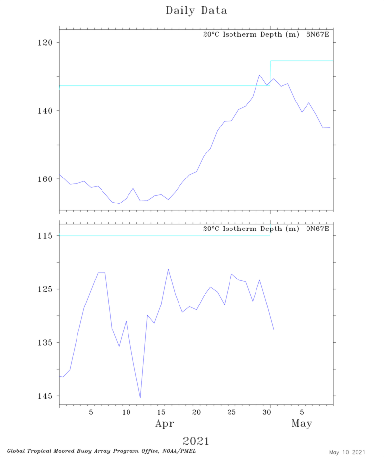
Figure 4: Evolution of depth of 20C isotherm from 1 April 2021 to 10 May 2021 at loactions 8°N, 67°E (southeast Arabian Sea, top figure) and 0°N, 67°E (bottom figure).
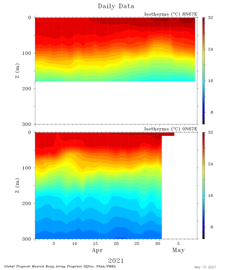
Figure 5: Evolution of surface and subsurface temperatures at location 8°N, 67°E (top figure) and 0N,67°E (bottom figure) as observed from RAMA mooring.


No comments:
Post a Comment