Jet Streams: A short Note on how to connect "Low" formations by reading the Jet Streams...Excerpts from Haby
The jet stream is a fragmented global wind flow that encircles the mid-latitudes in a wavelike pattern. Embedded within this global wind belt are jet streaks. A jet streak is a segment of the jet stream that has relatively high velocity winds. Other terms for a jet streak are a jet max and a jet surge. Jet streaks are caused by a large low-level temperature gradient, thus they are more intense in the cool season when the differential in temperature between the polar regions and tropical regions is largest. Jet streaks are analyzed near the 300-mb level. Find jet streaks on the UNISYS 300 mb panel below:
//weather.unisys.com/nam/300.php
It is a common error for beginning weather analysts to assume that the "entire" jet streak is moving at 160 knots. Think of a jet streak as an analogy to that of a thunderstorm. The thunderstorm moves at a certain speed (say 20 knots) while the winds within the updraft and downdraft of the thunderstorm move at a much faster speed (say 60 knots). The same is true for a jet streak. The jet streak itself may be moving at 25 knots while the winds moving through the core of the jet streak move at 160 knots. The wind accelerates as the air approaches the jet core and decelerates once leaving it.
A jet streak moves within the trough-ridge pattern at the same time it influences the amplification or de-amplification of the trough-ridge pattern. The example below is that of a jet streak de-amplifying a trough. A strong jet streak on the right side of a trough will cause that trough to de-amplify (lift).
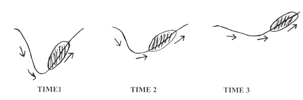
If a strong jet streak is on the left side of a trough, the trough will amplify (dig) as shown below.
The jet stream is a fragmented global wind flow that encircles the mid-latitudes in a wavelike pattern. Embedded within this global wind belt are jet streaks. A jet streak is a segment of the jet stream that has relatively high velocity winds. Other terms for a jet streak are a jet max and a jet surge. Jet streaks are caused by a large low-level temperature gradient, thus they are more intense in the cool season when the differential in temperature between the polar regions and tropical regions is largest. Jet streaks are analyzed near the 300-mb level. Find jet streaks on the UNISYS 300 mb panel below:
//weather.unisys.com/nam/300.php
It is a common error for beginning weather analysts to assume that the "entire" jet streak is moving at 160 knots. Think of a jet streak as an analogy to that of a thunderstorm. The thunderstorm moves at a certain speed (say 20 knots) while the winds within the updraft and downdraft of the thunderstorm move at a much faster speed (say 60 knots). The same is true for a jet streak. The jet streak itself may be moving at 25 knots while the winds moving through the core of the jet streak move at 160 knots. The wind accelerates as the air approaches the jet core and decelerates once leaving it.
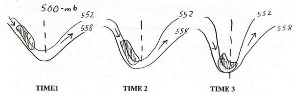
A jet streak moves within the trough-ridge pattern at the same time it influences the amplification or de-amplification of the trough-ridge pattern. The example below is that of a jet streak de-amplifying a trough. A strong jet streak on the right side of a trough will cause that trough to de-amplify (lift).
If a strong jet streak is on the left side of a trough, the trough will amplify (dig) as shown below.


5 comments:
Rayalseema SE Andhra is suffering from heat wave. Schools closed to protect from heat. Wait for NE monsoon (if happens).
Nice info sir. Got to learn something new.
Rajesh Sir what r the forecaste in Mumbai for coming days
Hi Rajesh, you had made a comment about Gujarat on the side snippets ? Could you elaborate a bit more with your current thoughts on when Gujarat could expect the monsoon? Both South and North Gujarat ? I know with the current weak strength it looks a bit far away to state precise dates but request more just as a general idea. Thanks.
Suresh
Raining very heavy in Chiplun. More than yesterday. Looks like 150-200 mm easily today.
Post a Comment