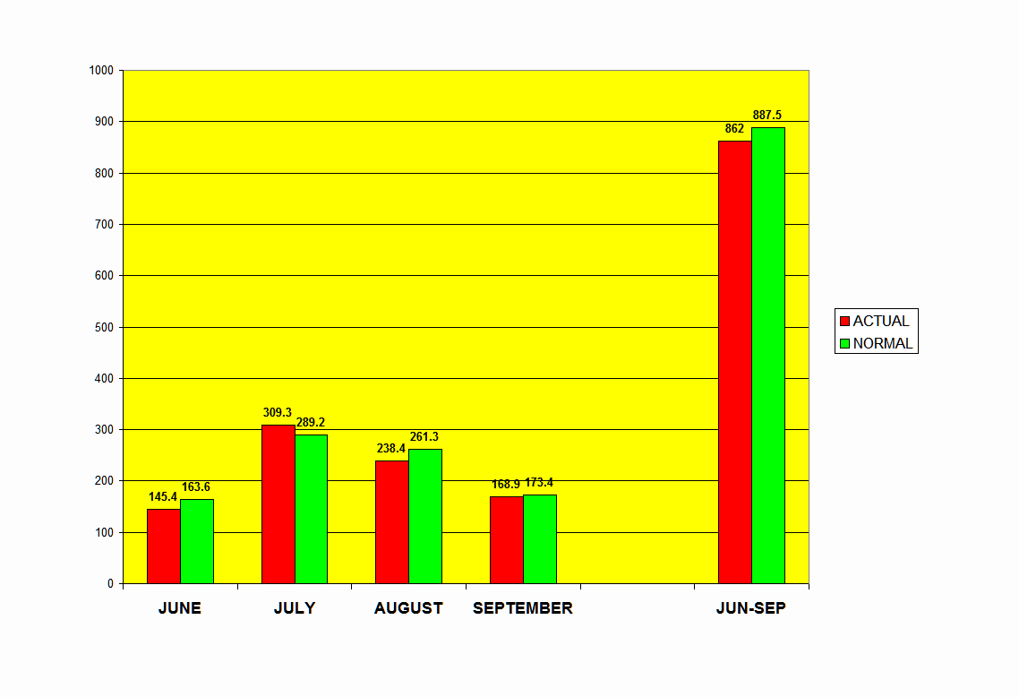
| FINAL MONSOON REPORT (01-6-2016 TO 30-9-2016) |
| TOTAL ALL INDIA RAINFALL this season (as on 30-9-2016) | 862.0 mm |
| SEASON +/- | -2.87% |
| RAINFALL PER DAY from 01-06-2016 to 30-9-2016 | 7.07 mm |
TOP TEN SUBDIVISIONS ACTUAL
| KONKAN & GOA | 3549.8 |
| COASTAL KARNATAKA | 2428.8 |
| SHWB & SIKKIM | 1996.2 |
| ARUNACHAL PRADESH | 1699.1 |
| A & N ISLAND | 1562.6 |
| KERALA | 1352.2 |
| EAST MADHYA PRADESH | 1249.4 |
| ASSAM & MEGHALAYA | 1249 |
| N M M T | 1244 |
| CHHATTISGARH | 1176 |
BOTTOM TEN SUBDIVISIONS ACTUAL
| HIMACHAL PRADESH | 624.5 |
| N. I. KARNATAKA | 525.7 |
| S. I. KARNATAKA | 524.5 |
| JAMMU & KASHMIR | 481.8 |
| SAURASHTRA & KUTCH | 416.9 |
| RAYALASEEMA | 392.2 |
| PUNJAB | 352 |
| HAR. CHD & DELHI | 338.3 |
| WEST RAJASTHAN | 315.8 |
| TAMILNADU & PONDICHERY | 258.1 |
TOP TEN SUBDIVISIONS ABOVE NORMAL
| EAST RAJASTHAN | 32% |
| KONKAN & GOA | 22% |
| MARATHWADA | 21% |
| WEST RAJASTHAN | 20% |
| EAST MADHYA PRADESH | 19% |
| WEST MADHYA PRADESH | 19% |
| TELANGANA | 19% |
| COASTAL ANDHRA PRADESH | 14% |
| MADHYA MAHARASHTRA | 12% |
| VIDARBHA | 9% |
| TAMILNADU & PONDICHERY | -19% |
| COASTAL KARNATAKA | -21% |
| S. I. KARNATAKA | -21% |
| GUJARAT REGION | -24% |
| HIMACHAL PRADESH | -24% |
| LAKSHADWEEP | -25% |
| HAR. CHD & DELHI | -27% |
| PUNJAB | -28% |
| ASSAM & MEGHALAYA | -30% |
| KERALA | -34% |
CATEGORY WISE SUBDIVISIONAL (%)

% DISTRIBUTION ABOVE/BELOW DAILY RAINFALL


2016 RAINFALL IN PERSPECTIVE

source:IMD


19 comments:
well done GSB..well depicted !
Excellent Work GSB!..Very well explained..
Very well done summary. Keep up the good work going.
wonderful as always been ...GSB sir.. lovely for sharing your compilation here
Kudos. Excellent work Sir.
It is very strange -> one day some model map shows"Anti cyclone" over RAJ stating monsoon withdrawl, next day it becomes "cyclone" with UAC - rains over GUJ/RAJ?
Entire GUJ pounding rains -> 200mm max some areas.
South no sign any rains October is passing away soon.....TN heat wave conditions.
Thanks Rajesh Sir and everyone.
I was intending to add the district top and bottom stations to the post but for lack of space and formatting issues did not do so. Will put up a All India district only monsoon toppers and laggards in a day or two.
Gurvinder.
Rajesh Sir, why has IMD declared withdrawal of SWM from some more parts of NW India when the winds are constantly ESE over the region and the moisture content has still not reduced? And why ARE these conditions persisting over NW India in the first place? Its the first time I am seeing such weather conditions during Navaratri in NW India! Usually winds started blowing from the NW with the formation of a strong anticyclone over the region as early as mid- to late-September, and by this time in October we started enjoying cool,crisp nights and misty mornings! Hope this weather ceases soon!
@Rajesh
I have the same question as Ishan.
Late withdrawal and and at the same time September rainfall was way below normal. Take Delhi for example. Almost no rain in the last one month. http://www.cpc.ncep.noaa.gov/products/global_monitoring/precipitation/sn42182_30.gif
Extended monsoon(technically) but no rain
Wind direction criteria not really met. Humidity levels high. It is almost as if out of sheer fatigue IMD is withdrawing the monsoon :).
By the way change seems to be coming. Amritsar morning low went from 7 above to 3 above normal.
Rajesh you did forecast a drop but maybe you can share more details in the next report. Last time you just mentioned Delhi and MP and did not touch upon North India.
Ishan/Saurabh: Please see a brief in Flash Snippets. I see the Monsoon withdrawing from North/West and Delhi by Friday. Yes, it was quite dry last 30 or so days. This was due to a variety of reasons...like Axis remaining South , upper air systems tracking thru Central India and the seasonal Low remaining more South activating the off shore trough in the West Coast.
But, after the current WD, we see a firm anticyclone formation, so technically we can mention withdrawal of the Monsoon.
Nights are bound to get cooler gradually from Sunday as North winds start blowing in the region.This will also bring drier conditions reducing the humidity levels next week.
Towns in Punjab may see a further drop in night temperatures by 2/3c from current 21-23c levels from Sunday. Days may however still remain around 33-35c.
In tropical climatic regions, things can change/differ than the initial forecasts at times. Even models like GFS & ECMWF may give different results for different runs each day. So though you may seem correct @Arjun, there is bound to be some degree of uncertainty especially during the season transition period :)
Rajesh , your technical explanations this monoon has been a fabulous experience for non weather people like me. Very lucid and easy to understand. And this has been backed solidly by the vagaries team like GSB and others by providing data spot on. In a way, it is a pity that we have probably only 3 to 4 days more of SWM to enjoy this. (Even though one particular person thinks that that the S in the SWM is meant to focus only on South !!!!!! )
Suresh
Rajesh, do you also have an outlook for the North East Monsoon this year ?
Suresh
Looking forward to nice and bright days in Mumbai, long long Monsoon season this. Although not much of a winter in Mumbai but I will take whatever reduction in Humidity and drop in temperatures Winter has to offer in Mumbai. Looking forward to the dry weather now.
October 2016 rains ( 1 to 7 Oct 2016 ) at some stations :
Osmanabad (Maha) @ 200 + mms
Surat (Guj)@ 177 mms
Alibag (Maha) @ 157 nmms
Ajmer (Raj) @ 120 mms
Amreli (Guj) @ 110 mms
Ahmedabad (Guj)@ 99 mms
Bhuj (Guj)@ 60 mms
Kolkata (WB) @ 8 mms
Delhi @ 4 mms
Bengaluru @ 0
Thanks Rajesh.
Some related observations
Monsoon of late is not withdrawing in the manner as documented in text books. For example it no longer takes 3 weeks to go from Amritsar to Gorakhpur. It is much more abrupt. For example this year for Amritsar the withdrawal date was 4th October. I will not be surprised if it exits Gorakhpur in the next 4 days.
Mumbai area should lose the monsoon by end of September. Here are the withdrawal dates of the last 5 years.
2015 15 Oct
2014 14 Oct
2013 18 Oct
2012 12 Oct
2011 23 Oct
Big deviation from the normal dates.
Even after the monsoon withdraws the humid weather continues through October so places like Pune have above normal night temperatures right through October similar to what North India is witnessing right now.
Let me clarify upfront, this does not really have any impact on North East monsoon. As i have pointed out in the past, 9 out of the last 12 NEMs have been above average for TN.
India..10 Most Populated Cities ..Rain in mms .. 1 Jun to 8 Oct 2016..
----------------------------------------------------------------------
1) Mumbai SCZ ..2974 mms
2) Kolkata AP ..1329
3) Surat.. 1103
4) Hyderabad .. 869
5) Ahmedabad .. 706
6) Pune AP .. 654
7) Delhi Palam .. 626
8) Jaipur.. 552
9) Chennai.. 537
10) Bengaluru .. 517
Mumbai way ahead of any other city.Hoping Final thunder shower helps to cross 3000mm :)
Post a Comment