Co Authors: GSB, Shreyas Dhavale, Pradeep John, Dr. Vineet Singh

Sunday, August 12, 2012

Saturday was the day of rains for the Central and Eastern regions of Gujarat.

What went right with the forecast :
The vortex formed in the Gulf of Khambat, and Khambat measured 45 mms of rain.
Sinor (Baroda dist) saw 90 mms and Karjan 72 mms.
Saturday Rains went into Gujarat from the East as expected, and having named Ahmedabad, Bharuch and Baroda, these two cities got good rains. Ahmedabad got 42 mms, Baroda 69 mms.
In surat dist, Mangrol saw 80 mms, Umerpada 55 mms and Surat, too got more than forecasted ( 15 mms for Saturday and 30 mms for Sunday) by registering 35 mms.
Bharuch measured 39 mms.
Gandhinagar measured 51 mms. Anand saw 52 mms.
Next in Line, Saurashtra ..
(Mumbai city forecasted is normally restricted to the island City. The city weather differs to a large extent with the weather in the hinter land. The towns  on the mainland get their rainfall influenced to a great extent  by the nearby hills around. Even the annual rainfall diggers from the city average and are much higher. 
The forecast put up for Mumbai cannot be carried to the outer townships. If require, we can put up a seperate forecast for towns across on the main land).

Mumbai Colaba got 23 mms and Scruz got 5 mms with vagaries measuring 7 mms on Saturday. The forecast (10-15 mms) put up (for Mumbai) is the average of these stations. Actual Average = 12 mms.

Coastal Karnataka rainfall shows a  decrease. From the previous days' extremely high 35-45 cms levels. Rainfall was between 15-18 cms on Friday, and even more on Saturday.
Saturday,s highest rainfall in the state was 148 mms at Kundapur.Other coastal stations were between 8-12 cms.

What went wrong with the forecast: 
Delhi NCR received  precipitaion in almost all the areas. Highest were at S'Jung with 18 mms, Palam and Lodhi Road 14 mms. Gurgaon 11 mms and Noida 7 mms. All other places got between 2-5 mms.
Vagaries' estimate was 5-10 mms. The day was at 35c as expected.

Indore got only 4 mms.

Next week's update tonite. 

Thursday, August 09, 2012


Mumbai Readings Updated.
As per Vagaries estimate (for Saturday Forecast below), Vortex forms today in the Gulf of Cambay...  

x--------------------------------------x-------------------------------x-------------------------------x
The axis of the monsoon Thursday runs through Rajasthan (Jaipur), South UP (bordering MP) and then thru W. Bengal into the Bay and thence again due east into Northern Thailand.

At present, on Thursday we see precipitation along the axis. Also, a weakening precipitation is seen along the Karnataka coast. Isolated pockets in coastal Karnataka have recieved upto 190 mms of rain Tursday along the Karnataka ghat regions. (Pradeep's report). This is seen as cumulus anvils in the satellite image of Thursday afternoon.

Possibility of the off shore trough showing signs of "relenting" off Karnataka by Friday.

Outlook for:
Friday 10th: We see the rains continuing along the axis. Rains will be seen in MP and Chattisgarh. More heavy rainfall concentration in West MP and adjoining Gujarat regions. Indore can expect heavy rains Friday evening.
Karnataka coastal regions will get heavy showers, with some stations recording between 12 -15 cms.
Isolated thunder in some pockets North of Chennai.
Friday, the axis remains in Thursday's position.

Saturday 11th: As the axis moves north, rains in the Central and Northern regions decrease. 

An embedded vortex (700hpa) may form for a day in the northern areas of the West coast trough (in the Gulf of Cambay). 
If this forms, the adjoining Gujarat coast (Surat) and the areas Northwards upto Ahmdabad will get good rains. Bharuch and Baroda will be covered in the region.
Simultaneously, the Southern part of the trough weakens, and rains along Karnataka coast will decrease.

Sunday 12th: Precipitation may show marked signs of decreasing in the Northern plains of UP, and in the North MP and Haryana regions. Marked decrease along the west coast too. West coast trough weakens. 
Interior regions of Gujarat get rains on Sunday due to previous moisture incursion. Drought hit Saurashtra may get rains on Saturday and Sunday. But on Sunday, rainfall will vary in Saurashtra between 10-30 mms.
Coastal TN gets some thundershowers. 

Monsoon axis possibly crashing into the Himalayas by Tuesday 14th/Wednesday 15th. Could create a break Monsoon condition early next week. But, shall confirm this by Sunday.

Pakistan Northern regions continue get showers on Friday10th and Saturday 11th. 
Regions East of Karachi, the SE corner of Sindh, can see some rainfall on Sunday.
Karachi will be cloudy, with light drizzles on Sunday. Hyderabad (Sindh) will be dry and windy. Day may touch 40c.
Sukkur will also be hot with gusty dry winds. Days may touch 45c this weekend.
Nepal Eastern parts get heavy showers Friday.

Cities Forecast:

Mumbai: some overnight showers on Thursday Night.
Friday 10th: Cloudy with bright spells. A few showers in some parts. Rain Amount Friday 8.30am-Sat 8.30am: upto 10 mms average.

Saturday 11th: Partly cloudy with sunny spells. Thunder heads may develop by evening. Rain Amount: 10-15 mms.

Sunday 12th: Sunny Spells. Thunder Heads may develop in the evening. A shower in some areas. Rain Amount: upto 10 mms.

Pune: Friday 10th/Saturday 11th/Sunday 12th: Partly cloudy to sunny. Light rains in some areas. Rain Amount 5 mms in areas where it rains.

Surat: Expect heavy rains on Saturday and Sunday. Sunday could be with thunder. The days will be overcast, with intermittent heavy showers. Rain Amounts: Saturday Sturday 8.30 am to Sunday 8.30 am: 15 mms and Sunday : 25-30 mms. 

Delhi: Friday 10th/Saturday 11th/Sunday 12th: Partly cloudy with a thundershower in some areas in the evening. Days will be around 35/36c. Rain Amount: upto 5-10mms/day where it rains.

Bangalore: Friday 10th/Saturday 11th/Sunday 12th: Cloudy, with sunny spells on Sunday. Sunday may see a rise in day temperature to 30c. Rain Amounts: 5-7 mms /day in the areas where it rains.

Hyderabad (India): Do not see any meaningfull rains in the Hyderabad region. Cloudy and warm days. With less than 3 mms/day where it drizzles.

Chennai: Chennai has been reporting between 10-30 mms last 2 days, Wednesday and Thursday. Next 3 days, may see:
Evening thundershowers in some regions on Friday, and possibly on Sunday. Areas which get rains will get upto 10-12 mms /day. 

Wednesday, August 08, 2012

Latest Pics from Mars on Space News Page...

Modak Sagar, one of the lakes supplying water to Mumbai has overflowed..See Mumbai Page for levels of individual lakes..and storage capacity..BTW, press now has reached Vagaries' figure of 238 days water availibility..

A good example below of Image showing perfect clouding along the Monsoon Axis Line..Image from IMD 4.00pm IST..west coast trough off Karnataka getting weak..


Rainfall expected along axis line Thursday..MP, East  Rajasthan and West UP...rains dragging to the west on the weekend.
Rains along coastal Karnataka and Kerala for one more day...
Detailed forecast for Weekend will be put up tonite (Thursday Night).

x------------------------------------x---------------------------------------x-------------------------------x-----------------x
This is the current situation. As it is late by the time i put up this post, and due to time constraint, i am not puting up a forecast now...shall put up next 2/3 days forecast by Thursday 12.30 pm IST.

Vagaries' has imposed the diagram over the IMD Satellite Image showing the Monsoon Axis. (Below)
The Elongated Low over Pakistan is the Seasonal Low...And the otehr lows seen in the axis are normal. 

Actually an axis is the joining line of such lows. Its NOT any system. 
(The "low pressure" mentioned hitherto in the IMD bulletins has never been announced in Vagaries, as, no chart, not even the IMD MSLP charts, show any such system. Vagaries has mentioned an UAC.)
Check the clouding along the axis. 

A trough runs from the Eastern end of the Axis along the east coast. A feeble trough runs South of the Karnataka coast.

Tuesday, August 07, 2012

Mumbai Page Updated with Wed. Morning Readings v/s Estimate.

On Tuesday, the UAC at 850 hpa moved Northwards, to ultimately merge with the Monsoon axis. 
That means, by moving North, it has avoided the Gujarat region, which it was expected to move into on Wednesday.Surat and Bharuch seem to have also been by-passed. 

Rainfall has now shifted along the axis. Delhi NCR can expect good precipitation along with adjoining Rajasthan region. Again, rains may creep into H.P. hills.
The axis has slid slightly southwards along the Rajasthan/Delhi/ UP and North Orissa line.

The 2 day very heavy rainfall patch in Coastal Karnatak and adjoining North Kerala ( Vythri =223  mms) and Southern most Konkan (figures put up by Pradeep)was surprising and largely unexpected.

A brief technical Analysis of the 2 day downppour (without going into too much details):

Though vagaries had mentioned of a "lift" in the trough (on Tuesday), which actually occured on Sunday/Monday, the strengthening was to the extent of vertical depth of -40. This was very breifly mentioned in vagaries on Monday.But, charts show, which ,frankly, i studied after the event, the vorticity at 850 hpa level 80. (raised to -5).

On seeing the maps of Sunday/Monday, i find the wind shear to be unusually low in the coastal Karnataka region, and the Lifted Condensation Level is seen at only 200 meters, and free Convection level fell to 300 meters. This aided with a off shore favourable CAPE, as the charts show, brought in a spell of very heavy rains ranging from 300-500 mms/day, as Preadeep has shown.

Let me admit, this is just an after "the happening "analysis. It was never pre-empted nor foreseen. 
Such is the suddenness and Magic (and Vagaries) of Weather! Keeps you always interested and on your toes. 
Is full of Surprises for the Weather enthusiasts!


Massive Rains in Karnataka (Drought to Floods within 3 days)...From Pradeep.
--------------------
The monsoon that played traunt for more than a year is in full vigour in western Karnataka reviving the lost hopes of people. The Malnad belt of the state from Belgaum district to Kodagu and coastal areas received heavy rains. Karnataka as a state recording a whopping 175% surplus across the four geographical regions in the last 24-hours ending 8.30am today. Malnad and coastal parts including Dakshina Kannada bore the brunt recording 360% and 152% departure respectively from normal weighted average while south-interior and north-interior Karnataka received 86% and 34% surplus rainfall.

24 hrs Rainfall Figures

Some of the 24hrs rainfall in mm ending 8.30 am on 07.08.2012 are as follows

Karauru - 337
Indabettu - 308
Mastikatte - 265
Yadur - 238
Hulikal - 235
Kammardi - 229
Mani - 228 
Nilkund 225
Nariyandada - 222
Thirthahalli - 210
Umbalamani - 203
Devanahalli - 203
Bandal - 203
Kollur - 201
Kalasa - 200
Kalasa - 197
Sringeri - 196
Meguda - 196
Hebri - 190
Perdur- 190
Siddapura - 187 
Subramanya - 187
Vanagur - 187
Dharmasthala - 180 
Hosanagara - 180
Jayapura - 180
Koppa - 180 
Talaguppa - 170
Agumbe - 172


Other Massive Rainfall Figures
--------------
Some of the other massive rainfall stats in past two days are as follows as on 8.30 am on 06.08.2012 -

Birunani - 559 mm
Parakatageri - 508 mm
Teralu - 305 - mm 

Further, Nagara recorded 746 mm rainfall in 48 hrs ending 05.08.2012 

Bisile, Kempuhole, Moorukannugudda, Kenchanakumari and the Bajemane reserve forest received 600 mm of rainfall in the 36 hours ending 05.08.2012

Dam Levels 
----------------
Linganamakki reservoir has reached 1,779 feet against the maximum level of 1,819 feet
Kabini stood at 2,277.35 feet as against the maximum of 2,284 feet.
Harangi reservoir reached 2,856.79 feet against the full level of 2,859 feet
Bhadra reservoir too increased to 150.50 tmc ft against maximum of 186 feet 

Sunday, August 05, 2012

Fantastic Maharashtra Toppers from Pradeep:  1st Aug-6th August..Inter Active Page..

Mumbai Page updated with Tuesday Morning rainfall with estimate comparisons.

Drought affected regions of India (as on 5th August ) map on Current Weather Page ...
Mumbai Lakes Storage as on 6th August put up on Mumbai Page...

The current UAC moves inland over Orissa and is tracking Westwards. 

As the UAC extends from 850 hpa to 500 hpa levels, the clouding in the S/SW quadrant is fairly strong and effective. 
UAC will track westwards and fizzle out by Wednesday,8th. (Weak MJO does not sustain any system for long).


Monday 6th/Tuesday 7th: Rainfall moves into Chattisgarh and adjoining East Vidarbha. Vidharbha and adjoining Marathwada and adjoining MP may get good precipitation. Parts of Northern AP too can expect good showers. 
Nagpur gets heavy rains on Monday/Tuesday. Rain Amount : 50-60 mms.

Relief for flooded rivers of UP as the rainfall in UP and Utteranchal decreases drastically.(flooding was predicted in vagaries' forecast last week). 

Delhi NCR sees no significant increase in rainfall  on Mon/Tues/Wed. Days will be around 35c.

West coast off shore trough, presently very weak (Sunday), just gets a little temporary "lift" on Tuesday, specially off the South Konkan coast, as the trough strengthens "aloft' (700 hpa).

Wednesday 8th: The rain area moves west, and diminishes in area. The heavy rain concentration will be at the meeting point of Maharashtra, Gujarat and MP. Heavy rain in North Maharashtra, adjoining SE Gujarat, and south Rajasthan.
Surat and Bharuch will get good rains on Tuesday night/Wednesday. Surat can get upto 25 mms.
But, west trough backtracks again, and rains remain weak along the entire west coast.

South India remains in the same "phase", with local convection pockets of heavy showers. 
From Wednesday, 8th, an easterly pulse could move in, embedded with an UAC, and precipitate rains commencing from the TN coast inland. 
Much needed rain may greet the TN and adjoining Kerala areas on Wed/Thursday.
Chennai sees a slight increase in rains after Thursday.

Mumbai: 
Monday: Cloudy with 3/4 showers. Not persistent, but a couple of them could be heavy in bursts and in some areas. Rain Amount: 10-15 mms.
Tuesday/Wednesday: Cloudy, with rainfall decreasing. Rain Amount: Upto 10 mms/day.

Pune: Partly cloudy, more sunny on Wednesda, as days will rise to 30c. Rain amounts : 3-5 mms/day.

Pakistan: A WD moving across extreme North Pakistan has interacted with the Easterlies from "above" the axis and brought heavy rains in Northern Pakistan. Vagaries had predicted heavier than normal rains for North Pakistan in its seasonal and monthly forecast. Figures like 139 mms in Islamabad yesterday, and Guranwala got 123 mms yesterday and 83 mms today. Lahore got 79 mms yesterday and 47 mms today. Rawal pndi got 75 mms yesterday.
Rains decrease from Monday 6th in the North.
Very light rains are likely next 3 days in parts of Sindh. Sukkur may get a dust storm or thundersquall.


Week's Analysis of All India Rainfall by GSB on Inter Active Page..must Read.


Saturday, August 04, 2012


Pradeep has done an encore for Vagaries...Latest list of SWM toppers, and a special list of "bottoms" also....On Current Weather Page.Definitely Worth seeing.
Thanks Pradeep on behalf of all Vagaries Readers.


Latest Up Date as on Saturday,4th Aug. 12.30 pm IST

An UAC at 500hpa/700hpa level, and descending weakly to 850 hpa levels has formed off the Orissa coast, and seems to be stabilising.
The UAC, is expected to move west, and cross into Orissa and move into Vidarbha region of Maharashtra from the East.

Saturday: Heavy rains in Orissa, specially Bhubaneshwar. adjoining Chattisgarh and adjoining Vidharbha start getting rains too.
Sunday: Heavy precipitation in Vidharbha and adjoining MP. Nagpur will be overcast with frequent showers, some heavy and persisting.
Monday: Good precipitation in Vidharbha and adjoining Marathwada. MP too gets good rains with heavy falls in the Eastern regions.
Till Monday >Delhi region remains cloudy with no meaningfull increase in rainfall. Almost status Quo.
South also almost the same. Some increase in rains along TN coast and Chennai from Tuesday. Details of next forecast will elaborate on this.

Pakistan: Punjab (Pakistan) gets good rainfall Sat/Sun. Lahore and regions around may get very heavy rains.
Mumbai:Saturday: Cloudy, with 2/3 showers in the evening. May not be too persisting. Night will see a couple of heavy showers in different parts. Rain Amount till 8.30 am Sunday: 20-22  mms.
Sunday: Cloudy, showers frequency increasing to around 4/5 heavy showers. But, again, rainfall variation will prevail in different areas, showing inconsistency in the strength of the trough and rainfall. Rain amount: from 8.30am Sunday -8.30 am Monday: Around 25-30 mms.
Monday Day time forecast.: Cloudy, with overcast at times. But brightening by late evening. Some heavy showers in the day will seem lengthy, but will not last very long.frequency decreasing by evening . Rain Amount till 8.30 pm Monday: 20-25 mms.

Pune: Saturday,cloudy and overcast with light rains till evening.Decreasing later. Rain Amount : 5-10 mms. Sunday/Monday will see lesser rains for Pune.

Curiosity Precisely on Course at T Minus 48 Hours till a ‘Priceless Asset’ Lands on Mars..See Space News Page.

Wednesday, August 01, 2012


Gujarati Newspaper puts up this article on 2nd August..those interested can read it here...and was put up headlines here..


City Wise city performance till July 31st 2012 with diagrams..Current weather Page.

Taking into consideration all the parameters and possibilities, and without going into the details of each place mentioned, i would summerise and estimate the amount of rainfall for August in selected Cities as follows:


Estimate for August Only:
Mumbai : 320-370 mms (Avg of Scruz and Colaba). Normal 496 mms.
Pune: 210 mms (Please note the 87 mms measured on 1st July is taken in August quota as per norms). Normal: 125 mms.
Thane: 470-500 mms. Normal: 637 mms
Ahmadnagar:  50-60 mms. Normal: 98 mms
Surat: 180-200 mms.    Normal 260 mms.
New Delhi: 150-170 mms. Normal 258 mms
Bangalore: 100-120 mms.  Normal 142 mms
Chennai: 80-100 mms.    Normal 140 mms.


As I have mentioned, the All India rains will be around 20-22% deficient for the Month, and the Over All Seasonal deficit end August may be around -18% to-21%.


Special Monsoon Watch for August:-


Deviating from the routine, This additional MW has become necessary due to the SW Monsoon's poor performance in June and July 2012. 


Seasonal Rainfall from 1st June - 31st July 2012;
Indian Regions: 
NE  -10%  NW  -36%  Central  -15%   South Peninsula  -23%.India: -19%.  


Analysis of India as a whole shows: 89% of India is in the deficient range (deficient range is -1% and below. Not -20% as taken by IMD.).
11% is in the normal range. (Normal means actually in the positve range).


The best performance yet is Sikkim and adjoining W.Bengal at +16%.
Most deficient is Saurashtra and Kutch at -79% followed by Punjab at -67%.


What has gone wrong this year?


The reasons for deficient rainfall could be attributed to the late arrival and subsequent weak monsoon conditions over the country, the axis of monsoon trough remaining shifted to the north of its normal position, and non-occurrence of low pressure areas (or land lows) across the country.


Also, uneven spatial and temporal variability within the season may result in deficits in the seasonal mean all-India rainfall (AIR) which can have profound social and economical consequences.


What actually plays an important part for a good Monsoon? 


The years 1965 and 1972 were years of severe drought over India and its surrounding area. The dynamical and thermal features of these seasons are contrasted with those of the normal monsoon. The main local abnormality during drought years is the shift of the monsoon trough northwards and the development of anticyclones over central India in the lower troposphere.


Drought years are associated with lower chances of low pressure areas to intensity into depressions, less westward movement, more horizontal extent, intense pressure departure from normal in comparison with flood years. However, more monsoon disturbances tilt significantly during flood years. The rainfall associated with these disturbances is highly variable and does not depend on the intensity, horizontal and vertical extent of the individual system. More number of lows intensify into depressions during strong monsoon conditions compared to those of weak monsoon conditions. Lows and depressions during strong monsoons have more westward movement and longer life period. Generally, very few lows form during break monsoon and none of them intensify into depression. 
Hence, the presence of mid-tropospheric heating during strong and weak monsoons is essential for the formation of depression. 


Parameters that will influence the August Rainfall:
The main and holding parameter is the location of the Monsoon Axis (Trough). Depending on the alighnment of this axis, the following vary and fluctuate: 


1. Systems form The Bay:-
It is the depressions and cyclonic circulations/storms that play an important role in the distribution of rainfall over the Sub-Continent.
This year, we have had BB1 and BB2 and in reality BB1 was as good as a non starter.
It is, therefore, of interest to know to what extent the absence of these synoptic systems causes deficient rainfall during the individual monsoon months. This aspect has been examined by computing the average rainfall of the different meteorological subdivisions of the Indian plains north of 15 degrees N lat. for monsoon months that were free from depressions and cyclonic storms. 


During the period 1891-1980, there have been 25, 13, 7, and 4 occasions of June, July, Aug., and Sept., respectively, when no depressions or cyclonic storms moved through the Indian land area.


A study also shows that the absence of monsoon depressions and cyclonic storms is not the main factor that causes deficient rainfall and consequent drought conditions in India.


Another study had shown that the occurrence of moderate to heavy rainfall mainly depends upon their frequency, life span, track followed and origin of these disturbances provided there are no inhibiting meteorological factors like `break' monsoon situations.

Initially, no system from the Bay is expected in the first week/10 days of August. A system BB3, is possible later. (See below)


Indicator for this August: Overall Favourable. 

2. MJO:-
The MJO wave shows weakness initially till the 12th at least, as it travels Eastwards. Currently it is still "within the weak circle".
While moving eastwards, it can trigger more typhoons in the West Pacific Ocean, and send a couple of more "pulses" into the Bay..around 12th/13th? 
After the 15th of August, forecasts say the MJO picks up again in the Indian Seas.


Indicator for this August: Favourable for 2/3 systems from the Bay in the second half.


3. ENSO:-
The ENSO conditions are likely to run through the Neutral conditions throughout August. As El-Nino is just on the "threshold" it is not expected to establish itself in August.
For most of month of July, the El Niño-Southern Oscillation (ENSO) demonstrated neutral values. The end of July, saw Niño3.4 at just threshold value. Nino 3 is the only sector above El_Nino threshold. 
Suspicion that the episode now developing in the Central Pacific may not be a normal El Niño and instead could be its variant El Niño Modokai (pseudo-El Niño). However, the latter can be confirmed as an episode only in September. 


During an El Niño Modokai episode, seasonally, it is the North-West region of India that usually bear the brunt of drought, followed distantly by peninsular or South India. Interestingly, this is how exactly the deficiency pattern is panning out this monsoon season.
Tropical cyclones formed during the year prior to the El-Nino years [El-Nino (-1) year] are seen crossing mostly (in 79% of cases) either north of 17 degrees N or recurving in northeastward direction. In other years this kind of behavior is not generally observed. 


Indicator for August: Getting Un favourable by the 3rd week of August.


4. SOI
The SOI is showing the latest as +0.9.


Indicator for August: Favourable for just about Normal rains.


4. SST:-
A preliminary study of synoptic sea surface temperature (SST) measurements made by ships plying over the north Indian Ocean has revealed the existence of an interesting ocean-atmosphere interaction. Large-scale monsoon failures over India during 1965 and 1966 caused an increase in SST in the Arabian Sea and Bay of Bengal. The warm seas may have been the cause of a persistent anticyclone that formed in the upper troposphere over the Indian seas immediately after the 1966 monsoon and persisted there until the monsoon of 1967, which was a normal monsoon. 


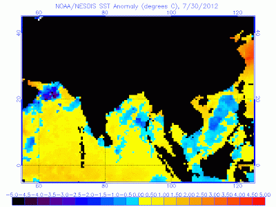
This is one parameter linked to the IOD and the IOD is predicted to be neutral..or mildly positive at +0.18...SST in the Arabian Seas are high presently, and high in the West/SW of the Bay...


Intensity of upwelling over the coastal waters of Somalia and Arabia (which is apparently regulated by the strength of the monsoon) is a factor with a major role in this interaction. These large-scale changes are found to affect the cyclone tracks also. This mechanism could, therefore, be the cause of the 3-yr oscillation in subtropical westerlies /tropical easterlies over south Asia, Indian monsoon rainfall, and tracks of the post monsoon severe cyclones of the Bay of Bengal observed during the decade 1965-1974 and reported by Joseph (1975, 1976).


Indicator for August: Again, just favourable for the Monsoon to "survive" not really "revive"


5. Jet Streams:-
During 1972, a year of large-scale drought in the Indian summer monsoon rainfall, the mean u-field at 150 mb shows a weaker than normal tropical easterly jet stream over south Asia and a stronger than normal subtropical westerly jet stream over Australia; the mean v-field shows that the cross-equatorial northerlies are weaker and displaced eastward by similar to 20 degrees long.


The two years (1970 and 1975) of highest monsoon rainfall for India of the decade 1970-1979 were compared with the two years (1972 and 1979) of lowest monsoon rainfall in the strength of the subtropical jet stream (STJ) over Australia as seen from an analysis of monthly mean u-fields of July and Aug. It is seen that, during the poor rainfall years, the STJ is similar to 20% stronger than in the good monsoon years.


It will be interesting if we find any similar occurrences this year. As yet the Jet Streams over Australia are much stronger. Easterly Jet Streams in the upper Himalayan regions are also very strong. Could possibly lead to rains in Northern Pakistan, possibly if they slide down a bit.


Indicator for August: Negative for good flow.


Forecast for August:


If we see and study all the factors, it’s quite puzzling and not leaning towards any one side..its something like "yes and No'. But that does not answer our question.


To summarise: 
The negative indicators may just about disrupt an ongoing monsoon process, but the the positive parameters, which may ensue later, may be able to at least keep up with the normal tempo. 
Initially, the Axis mves North, and possibly brings about a "break Monsoon" condition in the 1st week. Excessive rains in the Hill states and Upper UP. But east and west off shore trough becomes weak.
A couple of systems are possible from the Bay after the 12th, due to the MJO moving eastwards into the S.China Sea. 
An eastward propagation may lead the MJO into a weak phase during the first half of the month. The MJO phase, seeing its periodical wave, stands a chance of strenghtening after 15th August.
By end Augaust, El-Nino could rear its head, but meekly. 


Consequently, NW India, Interior Southern Peninsula and Gujarat would get deficit rains in the Month of August. 
Central India and NE would be normal, while West coast, Karnataka and Konkan could end up with slightly deficit rains during the month. 

Northern State of UP and the Himalayan Foothills region may get excessive rains, possibly leading to flooding downstream into Bihar.


Over all, on the ALL India Level, August can just about get the normal August quota. This means, the carry forward deficiency could end up around -17% to-21% level..


Pakistan: North Punjab can get normal/ slightly excess rains in the first half of August. We see no meaningfull increase in the Central (South Punjab and Sindh) regions till then.
If, as mentioned above, the couple of systems from the bay develop enough energy to generate rains along its track upto Pakistan (thru India), there is hope of a fairly reasonable revival of the monsoon in sindh and the southern coastal regions.


First half of the month will see very good precipitations in Nepal. Subsequently, normal rainfall will prevail. Nepal is already in excess, and August will further boost the surplus.


Compiled by Rajesh Kapadia with very useful contributions from Rajan Alexander.

Curiosity Landing on Mars..A Huge Event !..4 days from Mars !..See Space News Page.

  16th September;...afternoon Post Mumbai : September 16th : Thick cloud cover in  the day with few showers in spots. Night also with spotty...