Monsoon Watch 5-Arrival Dates.
As always explained, the MW parameters are to represent the progress of the developments in the Monsoon build up. On "as-is-where-is-today" basis, Vagaries calculates and forecasts the arrival date of the Monsoon. Again, these parameters are not referred in this MW for the quantum of rainfall.
The, normally expected and much talked about (in our MW series) low from the Bay came and became a Cyclone, adding much vigour and momentum to the SWM.
Current Status:
Bay factor: In the Bay sector, the SWM has moved into the South Andaman Seas on the 14th of May, and into the rest of Andaman on 16th. This pull was aided by the Cyclonic storm "Mahasen". In the Bay sector,the attached UTH map shows the advancing of a SWM current in the Southern regions

The cross-equatorial wind is re-building and reorganising again across the East Indian Ocean. SW winds are clocking 30 knts South and SW of Sri Lanka.
Onward Monsoon progress Northwards towards the NE States will have to be monitored, but the approximate dates are shown in the map.
The latest winds in the Bay continues to show strong winds rushing Northwards along the East coast of India, and re-curving into a Westerly flow of winds at the South Myanmar coast.
A lone pre-Monsoon low (B-1) had appeared in the region (early May) this year.
Indicator : +ve
The cross equatorial flow: This flow off the African Coast, in the Western Indian Ocean, this was a bit "disrupted" previously, but has now re-formed itself fast, and is strong off the African Coast South of the Equator.
The Somali Current, is getting defined, and blowing strong, with winds at >35 knts off the coast! We will wait for the Somali coastal SST to drop further.

In the map, observe the difference in SST along Somali Coast and Central Arabian Sea.The SST off theSomali coast is 23/24c.
The previously weak factor, the equatorial cross flow South of the Arabian Sea, is steady.
With a Low forming in the SE Arabian Sea by the 19th of May, the winds will gather speed, and enhance clouding in the mid- Arabian Sea.
The Mascarene highs are established at 1030 mb, are are now "pushing" the South-Easterlies from below the Equator.
However, I feel, a real good booster is required for the Arabian Sea branch of the Monsoon.
Indicator: Improved since MW4
Seasonal Low: With the heat factor still lacking absolute "full strength", in the Northern regions, the Seasonal Low core in the Thar Desert is now somewhat "unsteady", with a core pressure at 1000 mb, and requires to spread more westwards, rather than east. This (pulling Eastwards) is happening due to recent WDs (M-1).
The heat waves are just about to revive. However, the minimums still showing vast regions in the below normal range. By this time each year, vagaries normally charts the "above 30c" minimums. But this year as yet, forget 30s, we are still barely reaching 26s in the night, with the odd one out in the NW plummeting to below 20c recently.
And the days ? Good, and 47/48 is just about getting its foothold!
To refresh, reproducing a clipping from Vagaries of 10th May 2011: "Readings of 10th May:
Hottest in Asia: Larkana (Pakistan) 48c, Nawabshah and Jacobabad 47c.
Hottest in India: 45.2c at Khajuraho, Agra 44.7c, 44.5c at Brahmapuri.
Lows above 30c in India: Khajuraho 31c, Gwalior 30.7c, Gondia 30.4c, Kota 30.3c, Satna 30.2c. No lows above 30c noticed in Pakistan".
The Heat wave expected now, in the Western Sector of the Sub-Continent in next few days, will deepen the seasonal low and its core.
A North-South trough indicates the line of wind dis-continuity is unfavourably tilted towards the east in the Peninsula region. Normally, a perpendicular N-S trough is an ideal pre monsoon formation, and is a fore-runner for the seasonal low to stretch its presence over central India.
As mentioned in my MW prevoiusly, the creation of a good gradiant between Kerala pressure and Rajasthan/Sindh pressure is an absolute requirment. And that is a must for creating a pull Northwards for the Monsoon. Overall position in this parameter is improved slightly since MW 4.
Indicator: Neutral
The ITCZ now runs along the Equator from the African coast to Andaman Island. Normal,for it to touch the equator around the 10th. (For more read previous MW).
Indicator: +ve
The 200 hpa jet stream: Normally, they should be Easterlies right upto 20N by May end. This would facilitate the Northward movement of the Monsoon Current. Today, the Easterly jet stream is developing upto 10N. These 200 hpa jets winds normally need to come upto 10N by 15th.of May, so would consider this parameter as doing well.
Then move upto 10-15N before 20th.May, to be in time for the Maldives Monsoon arrival.
The 200 hpa jet streams did get a bit dis- organised in the Bay recently.
Indicator: Normal.
Arrival Time Conclusion:
Vagaries advance map for easy reading.
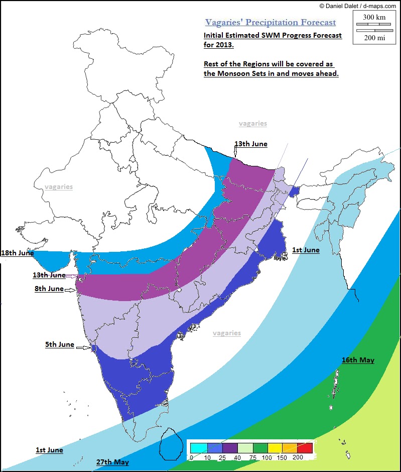
SWM has feebly moved into the Andaman Region.
SWM will start covering the complete Bay Islands to reach the NE states by the 1st of June.
SWM could be expected over the Maldives by the 20th of May.(Normal date 20th). Over Sri Lanka around the 27th of May.
I would estimate the SWM to advance into Kerala around June 1st/2nd could be the date for Kerala, but remain weakish till the middle of June in coastal Karnataka and Kerala.
Initially, as a result of a weak MJO wave, the SWM would be weak in Kerala in June. The further current into Kerala would be "reluctant" to move ahead in a weak MJO, as International forecasters predict the MJO phase in our seas to become weak up to the 10th of June.
Nevertheless, the SWM could progressively advance into Goa/coastal Karnataka from 5th June, and Mumbai by the 9th/10th. of June. .
SWM could delay advance into interior Karnataka and interior Maharashtra by a week from the 10th.
Around 18th of June, I would include entire Mah and South Gujarat as covered by the SWM. I would put the SWM in a weakish phase till the 15th.
Mumbai can get pre-monsoon thunder showers from 28th/29th May.
Pre-Monsoon thunder showers can be expected in the outer townships from the 28th/29th May.
(This Monsoon chase is my personal view, and my personal analysis and deciphering is done as per my assumptions. Should not be used for commercial purposes).
Next MW-6 will be published on 24th May evening.


7 comments:
Arun Kumar: Have put up my estimate of arrival dates...sure initially SWM is weak in interiors
Sam: I think pre monsoon showers will start from 28th/29th in Lonavala also..maybe a day delayed...
Prasad Godase: What can I answer to your question. Vagaries has put up the advance of monsoon in Andamans on 16th
Rajeshbhai, Though you have touched upon the low formation in SE Arabian sea, understandably not used it as a factor for MW-5. But looking forward do you think its track can affect the SWM progress
no signs of rain in bangalore today...its clear and hot so far
clouds formed around 5 and now its raining lightly in bangalore
as predicted by rajesh sir...raining heavily in bangalore!!
Pavan reports" chickmaglur aws 49mm of rain with 19.7°C temp
cool coffee town"
Emkay: This low was the not the "main " event for MW. But, I do not see it effecting the proposed arrival of 1st June, in fact it has gathered energy.
Post a Comment