
Latest on "Biparjoy" as on 12th Evening.
Very Severe Cyclonic storm, Biparjoy" , lost some steam to a small extent, as its winds are now surpassed the peak and slightly less at 145-155 Kmph. Cat.2. Was anticipated yesterday after touching about 20N.
As dry air entry is increasing, the overall convection cover is reducing. A band of convection still covering the circulation, the JTWC terms the core as a "Quasi Eye".
With the ridges alongside, expected track..heading towards the North Kutch/International border region.
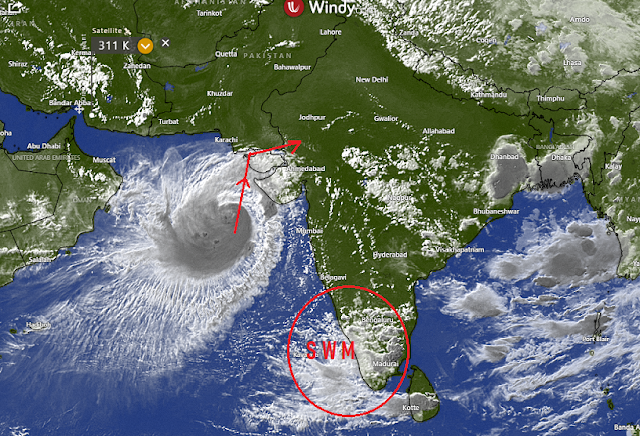
Alert: Very heavy rainfall and squally winds in Kutch, Western Saurashtra from 14th. Rains commence into North Gujarat and South Rajasthan from 16th.
Karachi & Southern Sindh will get heavy showers and rain from 14th to 15th, with squally winds.
Monsoon advance beyond South Konkan may be halted for a few days, as the Cyclone moves inland and disturbs the gradient along the West Coast.
Mumbai:
*Next 3/4 days will get light to medium Pre Monsoon showers. Squall winds around 30 Kmph.
*A slight reduction in rains after Wednesday 14th. No major increase in rainfall this week.
*A distinct absence of the usual thunderstorms is noticed. This is as "multi Layer" clouds are not seen. But thunder activity will soon resume.
*Days will be a shade better at around 33/34c, but humid. Real feel will be high (38c). Nights around 27c will be warmish.
*Wait for proper Monsoon is frustrating !😖
Pune: With warm days around 35c, will be almost dry, with few localised scattered rain patches.
Goa: Monsoon looses steam after Wednesday 14th...with little rains as the pull of the system reduces.

No comments:
Post a Comment