Posted Saturday Night:
The South Bay Low, BB-10, ( 9.1N & 85E) seems to be gaining as expected....currently and about 1006 mb now, and Well Marked, will now deepen and move towards the TN coast.
Chennai will get have a wet Sunday with occasional showers and rains increasing by Sunday night. Monday will be very wet and cool, with around 110-120 mms expected.
See the rain rate compared with BB-10 and AS-3...(Recent)

 "Megh" has strengthened, and now estimated core pressure is an average 990 mb. (See Graph below)
The core winds estimation is also varying a lot, and differs between 45 knts and 75 knts, averaging 60 knts (110 kmph). (See Graph Below).


Is "Megh" finally a cyclone ?...No...its not...yes it is ....Ok, So, JTWC says... let's call it a "Midget Size Cyclone"....

The South Bay Low, BB-10, ( 9.1N & 85E) seems to be gaining as expected....currently and about 1006 mb now, and Well Marked, will now deepen and move towards the TN coast.
Chennai will get have a wet Sunday with occasional showers and rains increasing by Sunday night. Monday will be very wet and cool, with around 110-120 mms expected.
See the rain rate compared with BB-10 and AS-3...(Recent)

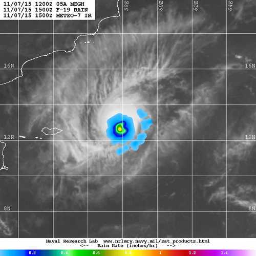
The various agencies differ on the estimate, as the Satellite imagery shows mixed and broken convective banding.. Graph shows the pressure regularly declining gradually last few days.
The core winds estimation is also varying a lot, and differs between 45 knts and 75 knts, averaging 60 knts (110 kmph). (See Graph Below).


Is "Megh" finally a cyclone ?...No...its not...yes it is ....Ok, So, JTWC says... let's call it a "Midget Size Cyclone"....
And this is from Rohit..at usual at his best...See Rohit's Page for Latest.
See Mumbai Page for last 30 days Temperature graphs


3 comments:
u said it - by Laxman (Rohitji)
West coast heats up today !! Some max temp below dated 7-11-2015:
Palghar IMD AWS 37.6c
Mumbai Scruz & Ratnagiri 36.5c
Thane IMD AWS 36.3c
Surat 36.2c
Murud IMD AWS 36.1c
The western side of Scotra received more than 41 centimetres (16 in) of rain from Cyclone Chapala in November 2015.Scotra is referred to as earths most alien looking place. 2nd cyclone is in pipeline - yemen desert??
Post a Comment