Posted Friday 26th Afternoon>>>
BB-2 is a Depression now. Core wind speed estimated at 40-45 kmph.
Likely with favorable conditions to deepen into a Deep Depression and possible (2) tracks shown.


------------------------------------------------------------------
Chances of CYCLONE FANI FORMing IN Southern BAY OF BENGAL
Today, a cyclogenisis initial stage is seen as cyclonic circulation over extreme Southeast Bay of Bengal and adjoining Equatorial Indian Ocean.
A Low is likely to form in the Southern Bay South East of Sri Lanka, around 5N and 90E, by 25th April.
That is BB-2 ...Models are indicating that the system would be initially moving in northwest direction. It is likely to get more marked during the next 24 hours from 25th and would be inducing a low pressure area by April 25.
That is BB-2 ...Models are indicating that the system would be initially moving in northwest direction. It is likely to get more marked during the next 24 hours from 25th and would be inducing a low pressure area by April 25.
BB-2 is to intensify into a Depression and track North West. Favourable atmospheric conditions would be further enhancing the strength of the depression.
1. Sea Surface Temperatures: Currently in favourable SST at 30c, but can go into cooler waters after 15N.
2. Vertical wind shear helping the system initially.
3. MJO (Madden–Julian oscillation): It is another key factor as movement of MJO through Indian Ocean at this time would lead to enhanced conditions for sustenance and rapid deepening of BB-2
This may turn into a deep depression and finally into a tropical storm in the subsequent three days i.e. April 29.
Season’s first cyclonic storm is most likely to be formed and be active.
When BB-2 strengthens into a cyclonic storm, it would be named as ‘Fani’
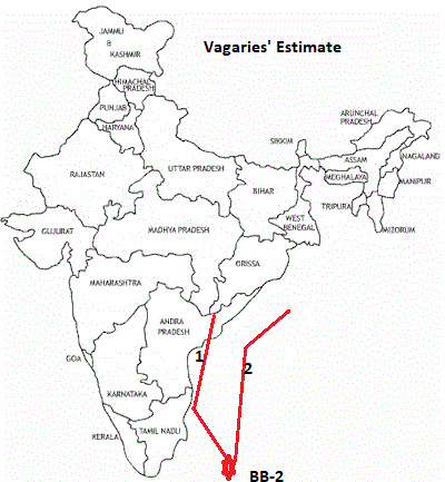
In both the scenarios, Tamil Nadu and Chennai would see rains and thundershowers . Scenario 1 would give some torrential rains over Tamil Nadu including Chennai but in scenario 2, the state would see light to moderate rains only.


8 comments:
Kindly use the latest Indian map
Very nicely presented- nice to have both the tracks depicted on map - lets wait and see it chooses the track-
Rajesh sir,your in depth analysis has never been proved wrong by nature...
Will low pressure cross Tamil Nadu / South Andhra to give blessing rains to 5 years drought impacted areas or move away to North East - Hope it crosses south east India...
Thanks a lot for your analysis on upcoming cyclone. One question will this herald an early onset in andaman this year.
Looks like Thithli route towards Orissa or NE India...
Tragedy for SE India - no rain.
This cyclone will take second path shown in the map ..
COURTSEY IMD
for more visit
http://www.rsmcnewdelhi.imd.gov.in/images/cyclone_pdfs/indian_1556357293.pdf
BOB/02/2019 :
The depression over East Equatorial Indian Ocean & adjoining southeast Bay of Bengal
moved further northwestwards with a speed of about 20 kmph in last six hours, intensified into a deep depression and lay centred at 0530 hrs IST of 27th April, 2019 near latitude 4.5°N andlongitude 88.0°E, about 870 km east-southeast of Trincomalee (Sri Lanka), 1210 km southeast ofChennai (Tamil Nadu) and 1500 km south-southeast of Machilipatnam (Andhra Pradesh).
It is very likely to intensify into a Cyclonic Storm during next 12 hours and further into a Severe Cyclonic Storm during subsequent 24 hours.
It is very likely to move northwestwards off Sri Lanka coast during next 72 hours and reach
near north Tamilnadu & south Andhra Pradesh coast on 30th April 2019 evening.
Post a Comment