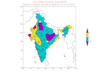
A moderate cold wave has been sweeping the Northern regions
of the sub-continent since 14th of December.
In the plains of India ,
we have seen a low of 1c at Churu on the 17th, and frequent lows of 2c at Amritsar , Karnaul, Agra Delhi
In Kashmir, Leh plunged to -13c as its lowest this season,
and Srinagar
Due to dry conditions, and absence of rains, the entire
southern peninsula was around 2c below normal.
The cold, even normal minimums, evades the coastal belt of
Mah. and Gujarat . Mumbai S'Cruz has not gone
below 16c, that too on one occasion and Colaba has reached only 21c on a single
night. The reason is obvious. See on the * below.
Across the Western border in Pakistan too, it has been cold in the
plains, with the capital Islamabad hitting below
freezing, at -1c continuously on several nights.Lahore, Gujranwala
and Faisalabad
In the Sindh region, Nokkundi has been bottoming 1c on a
couple of occasions, and the interiors of the region are cold at around 2-4c,
with Sibbi constantly at 2c.
The coastal city of Karachi
#For the entire region, I would attribute this cold wave not
to a W.D. but to a weather condition which i have explained in this blog
earlier.
It is due to a stationary high pressure zone over the
region. A constant high pressure area causes the skies to clear and a cold
front encroaches the area. In reality, it is an aftermath of a W.D. Currently
there is no precipitation.
* Hence, actually, there is no cold wind sweeping the
regions from the North, like it happens after a W.D.When the cols wave is due
to a direct W.D. effect, we have cold NW winds sweeping down and covering the
entire region and the West coast.*
Now, we have a weakish W.D. coming by the 20th. Weak,
because it is an upper air system. Being such, it should bring precipitation to
the upper hilly regions of the sub continent, and some good snowfall in Kashmir from the 20th. But rains will be scanty in the
plains of Punjab and Haryana.
That translates to an abetment of the current cold wave.
Mumbai, on the other hand will now
see more civilized day temperatures. The days at S’Cruz have been constantly
between 34-35c, almost since the beginning of this month. And obviously that is
above the normal of what this city should expect.
From the 19th/20th onwards,
I expect the day temperatures not to exceed the 31/32c mark. A gradual fall of
around 3c, and that too in the day. Most welcome I am sure !
The nights in Mumbai would be around the current level till the 25th.
Should hover around the 17c/18c mark at S”Cruz and around 21c at Colaba. From
the 25th to the 31st, I expect the nights to drop. Not too
much, but to around the 15c level, with an odd night at 14c, at S’Cruz, and to
the 19c level, with an odd night at 18c for Colaba.
On the other hand, I think Pune should expect the nights to
come back to the 13c/14c level, and drop again to 10c after the 25th
of December.
For the South, an easterly wave is expected to bring in a
spell of rain of the NEM. Around the 20th of December. Rains will concentrated
in the extreme south of the peninsula. Would be heavier in Sri Lanka
Another spell. Could be the ultimate, is pushing in to reach
the T.N. shores by the 25th.


2 comments:
Hi Rajesh, Its been long time.
Late December and early January Cyclones: Will it happen during 2011 or 2012
----------------
Many models predict cyclone to come close to Tamil Nadu coast during last week of December 2011. Off late GFS is not so accurate in its forecast.
I have compiled some of the cyclones which have formed in December and have crossed Tamil Nadu coast since 1950.
http://tamilnaduweatherman.blogspot.com/2011/12/late-december-and-early-january.html
hello Pradeep: Doesn't look like a cyclone this year. a depression at the end of the year.
Post a Comment