Co Authors: GSB, Shreyas Dhavale, Pradeep John, Dr. Vineet Singh, Gokul

Monday, June 14, 2010

The pulse from the bay "low" has fulfilled its duty!The predicted upper air cyclonic circulation is in the forming stage off the west coast today (IMD Map). The Maharashtra coast has been spotted with heavy rains since Sunday night 


(IMD rain Map), and Mumbai getting a drenching on Monday morning with a heavy thunderstorm.Sawantwadi recieved 230mms,Vengurla got 190mms,Goa 65mms and Ratnagiri 46mms. 

During this week the system could start attracting the flows towards itself and cover the entire west coast. 
FNMOC forecast shows a swath of rains along the Konkan-Mumbai-Gujarat coast from Tuesday, this week.The system, with the off shore trough, will be raining down over the western coastal areas over the rest of the week.

On the contrary, the eastern coast, comprising Tamil Nadu, A.P, and Orissa, will be much drier with scanty rains during the week in discussion. I see the "low" fizzling out "on-the-spot" near the T.N.coast itself by Monday itself. But the region North of Orissa coast would continue to get heavy rains.

After Wednesday 16th,, some model forecasts show the Northern most point on the west coast( read Gujarat), upto Mumbai, getting drier comparitivly, to some extent. But, the precipitation outlook from NCEP and FNMOC suggest  the west coast as a whole would receive fiarly good amounts of rainfall during the week ending June 20.
Resultantly, we should see the entire peninsula and the southern parts Gujarat and M.P. covered by the monsoon during this period.

Mumbai Colaba had recieved 30mms of rain upto 08.30 hrs on Monday. As per my forecast put up yesterday (13th.), the city should see an increase in rain from evening onwards,peaking tomorrow.
From Friday 18th, Mumbai may see the rainfall intensity diminishing, maybe to around 15-20mms /day.


From Our Partner Blog:
"your america today forecast". A detailed write up on America very well written by Mark.Read blog.

Sunday, June 13, 2010

Detailed Mumbai Forecast  for next 3 days:
A moderately strong Monsoon current will cover Mumbai region from Monday. An off shore low, embedded in the trough will precipitate rains starting from Monday.
Monday:
Day will be overcast with some drenching showers. Rain/Thunder frequency increasing by night.Good Chance of a Thunderstorm.
High: 31c. Real feel temperature will be 35c.Rain quantum (day and night) around 35-40mms.

Tuesday:
Day will have frequent spells of heavy rains/thunder, with chances of flooding and water logging. A typical monsoon day with gusty winds.
High will be 29c, and real feel temperature around 30c.Rain quantum (day and night) about 90- 100mms.

Wednesday:
Heavy rains will continue with occasional thunder and strong off shore winds. Water logging possible in the pre noon hours. Rain intensity might taper off after night. 
Rain quantum during the day about 65mms and 35mms during the night.

Saturday, June 12, 2010

IMD has announced the arrival of the Monsoon into Mumbai and Pune on the 11th. of June. IMD has based the arrival on certain criteria they have specified in their web site.
Maybe, but the monsoon current, according to me is still lagging (as on writing this) at the Goa coast, and today is not strong enough to progress Northwards.
The momentunm and push  into Konkan will occur when the vortex is formed off the Goa/Konkan coast, and the off shore trough is energised with the resultant clouding. And, as I have said earlier,(10th.blog),this should happen from Monday,14th.The low as a counterpart system  in the Arabian Sea off the Konkan coast could be formed as early as Sunday and should track off Konkan ( Mumbai included)-Gujarat coast by 15th. June.


But, the Monsoon has progressed into parts of Telangana, coastal Andhra Pradesh. The rain accumaltion map(NRL) of 12th. June (day only) shows the rainfall along the A.P. and Orissa coast. Western region is devoid of meaningful rains, except in Kerala. Extreme Northern rains are due to an upper air W.D.
Ok, in technical terms, we can say conditions are favourable for further advance into Maharashtra and Andhra Pradesh and southern parts of Gujarat, Chhattisgarh and Orissa during the next 2 days.
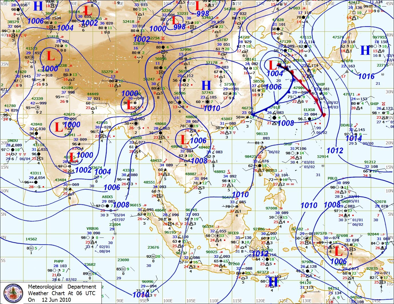
With the low pressure in the bay, now creating a "pulse" (see Thai Map) into the southern peninsula regions,monsoon winds  flow over Arabian Sea and Bay of Bengal would further intensify during the next 2/3 days.


Meanwhile due to the formation of a good off shore trough along the west coast, very heavy rains are possible over north Kerala and adjoining coastal and south interior Karnataka.


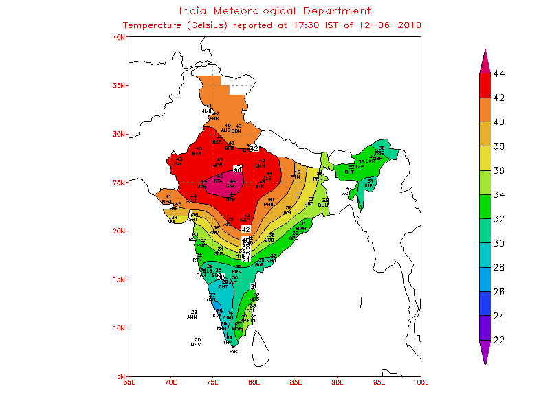
The required pre monsoon heat wave, discussed in the 9th blog, has resurfaced. Kota topped it today with 45.2c, and Delhi airport jumped to 44c. Several places have recoreded day temperatures in the 43-45c range.
Systematically falling in place, against 1002 mb seen on the 9th, the core pressure has fallen to 998 mb.Now we can hope for  the pressure in the seasonal low in the Sindh/Rajasthan region to fall a bit further and create the required gradiant to pull up and speed up the the monsoon winds along the Northern areas of the west coast.

Saturday,12th, June:
Highest in Asia: Basrah(Iraq): 49c
Highest in Pakistan: Sukkar: 46c
Highest in India: Brahmapur (Maharashtra) 46.1c

Mumbai: Rain on Friday (day and night); Colaba 1.7mm and Santa Cruz 1mm. Saturday no rain during the day.
 I stick to my earlier forecast, in fact I will copy/paste it from my blog dated 9th.
"Sunday/Monday will be overcast and more rainy, with rains measuring upto 20 mms/day.
Monday night and Tuesday will get very heavy rains, upto 150-200mms, with gusty winds. Typical monsoonish flooding weather on Tuesday,15th".
Add: rains will extend into Wednesday.

kapadias@gmail.com

Thursday, June 10, 2010

If we have a look at the rain fall distribution map of 10th. morning (IMD), we see some fairly good amounts of rain in Kerala and the North-East on Wednesday.The NRL rain accumalation map for the day of 10th. June shows some rainfall in South Konkan and Goa, and some parts of coastal Gujarat.
What I am coming to is still there is very sparse rainfall north of the Karnataka coast. I would justify an advance (of the Monsoon) North of Karnataka  only after the predicted Low comes into effect off the Goa coast.


The formation of a trough off the Goa coast (see map), still in the initial stage seen as an upper air low,and forming, may have inspired the announcement of the advance into South Konkan. In the MSLP map, a weak ridge is still visible in the Arabian Sea. (The reason for the North-West winds). This needs to be eliminated, to ensure a full fledged monsoon along the west coast, and for further progress into the interiors thence.
Progress in the sequence forecasted in yesterday's blog: The low in the Bay seems to be creeping inland, and is now a "pulse", which is expected to track westwards through Karnataka. All pieces must fall in place and the low must re-emerge in the Arabian Sea for the monsoon to move north from Monday as estimated.
Shall keep this space updated on the progress.
 
Hottest in Asia: Dammam Airport (Saudi Arabia)       47c
Hottest in Sub-Continent: Jacobabad (Pakistan):      44c
Hottest in India: Akola (Maharashtra) ;                        45.4c
Hottest Night: Chandrapur (Maharashtra):                 32.8c


kapadias@gmail.com

From Our Partner Blog: Football Special,For those countless football fans,
Winter World Cup Kicks Off Friday:
The 2010 FIFA World Cup kicks off this Friday and ends July 11, making it the very first World Cup to take place on African soil, and the first to take place during the winter since Argentina hosted in 1978.
 
A Winter World Cup?
South Africa is a nation of varying climate and landscape. During the Southern Hemisphere winter, South Africa transitions from warm days to mild and cooler nights.
In the mountains in the northeastern part of the country, temperatures can drop to near or below freezing overnight. In July, the city of Bloemfontein has an average high temperature of 17 degrees C (63 F) and an average low temperature of -2 C (28 F), according to the South Africa Weather Service.
Cities on the coast can also be cool due to sea breeze and current. The warmest cities during the World Cup will likely be inland cities that are low in elevation.
Coastal South Africa will be in the midst of a rainy season during the tournament. The rainy season brings considerably more rainfall to the coast than to areas inland.
Cape Town averages about 93 mm (3.66 inches) of rain in the month of June, and 96 mm (3.78 inches) in July. This may not seem like a lot of rainfall, but compared to Johannesburg's average of 7.6 mm (0.3 inches) in June, there is quite a difference between the two locations.

Altitude
Rainfall and temperature are not the only things players and spectators will have to deal with this time around. The altitude will be a huge factor and will likely have an effect on the ball and players' performance. Some teams chose to undergo altitude training to acclimate to the conditions.
In 2007, a FIFA ruling declared that no international matches can be played in an elevation above 2,500 meters (8,202 feet). Although the elevation in the mountain cities of South Africa is lower than the limit, someone not used to the altitude could still be affected.
Since each of the 32 teams will play throughout the country, a team may play one match at sea level and play their next one more than a mile above sea level. Six of the 10 stadiums used in the tournament are situated at least 4,000 feet above sea level.
To put things into perspective, both teams playing in the final match in Soccer City Stadium in Johannesburg, a high-altitude venue, will have played their semifinal match at sea level.
However, these sea-level semifinals are not as even-matched. Both semifinal matches will be played between a team that won its quarterfinal at sea level and a team that won its quarterfinal at altitude.

Weather for Opening Weekend
As for the first few days of group play, rain is expected this weekend along the coast. Cape Town could pick up more than 1 inch of rain from Saturday through Monday as a cold front comes through.
This rain could be seen during gametime, as Cape Town Stadium will host matches on Friday and Monday evenings. Across the inland locations, rain is not expected.
From Mark's blog.

Wednesday, June 09, 2010

Rains and Pleasant Weather in North:
Since Phet crossed into Northwest India, widespread rainfall has been reported from many parts in the region, as the system had interacted with a prevailing western disturbance, and formed the mini W.D,
The ongoing rainfall due to this in the North/Northwest has pushed the heat further South and South-east to cover pockets of  Bihar,  Orissa, and Chhattisgarh.
Also, as anticipated, heavy unseasonal snow  in Lahaul-Spiti and widespread rain in middle and lower hill areas provided much-needed relief to people from sweltering heat and dry spell.
The twin valleys of Lahaul and Sipti recorded heaviest snow for June for the past several decades. Keylong, the district headquarters, had received 10 inches of snowfall by the evening and it was still continuing. The Kunzum Pass and Kibber and other higher areas received even more.


The core pressure of the Monsoon seasonal low over the Rajasthan/Sindh region has suddenly gone up to 1002 mb, against a normal required at this time of 994 mb.Temperatures were well below normal since the last 2 days.(IMD Maps).
The Monsoon had not advanced beyond the Northern limit aligned Southwest to Northeast along Karwar, Bangalore, Cuddapah, Bapatla, Agartala, Dhubri and Gangtok which has been held on since on Monday.
Heat is again required to create the steep gradiant to pull up the Monsoon.

Heat Wave Forecast: 
I do not rule out the possibility of an extreme heat wave over Gujarat, Rajasthan, Vidharbh, and delhi/Haryana regions from Friday thru Sunday (11th/12th/13th). The regions in Gujarat and Rajasthan will have to gear up to face temperatures upto 46/47c, with an exceptional 48c in some pockets of Rajasthan.

Forecast for Monsoon Progress:
The Bay  has spun up a cyclonic circulation on Tuesday, which forecast to intensified as a “low”on Wednesday.This would track west and cross close to the Chennai coast.
The system would continue to track to the west and re-emerge into the Arabian Sea, near Goa by Monday, 14th. June. On entering the Arabian Sea, it seems it could get embedded in a offshore trough along the west coast. This could would help intensify the system, maybe into a depression, or a deep depression, and push it northward along the coast, according to international model outlook.
According to the ECMWF, the intensified system would be pulled up towards Mumbai-south Gujarat around June 15.
Most models forecast the system  would track India's west coast and head towards the Mumbai-Gujarat coast.

What is apparently becoming a certain possibility is for heavy rains over the Konkan/Mumbai/Gujarat region from June 15.
After the system enters into the Arabian Sea arena, say by Sunday,the Northward progress towards Mumbai would be watched carefully.The Monsoon arrival over Mumbai could be around Sunday/Monday.

Mumbai Forecast: Cloudy and passing showers, with the same hit and miss showers continuing in parts of the city till Saturday.
Sunday/Monday will be overcast and more rainy, with rains measuring upto 20 mms/day.
Monday night and Tuesday will get very heavy rains, upto 150-200mms, with gusty winds. Typical monsoonish flooding weather on Tuesday,15th.

Tuesday, June 08, 2010

The remnants of "Phet", while passing over the baked and over heated mainland in the Northern/North-Western Sub-continent regions, has precipitated fairly good rains and helped cool down the parched landmass substantially.Ironically,the Thar Desert on either side of the International Border,received the maximum amounts of rain in the past 2 days. And has resulted in bringing a "comfort zone" in the region .
In Pakistan, the heaviest rains were given in yesterday's blog, while even on Monday,some heavy falls were measured: (In Cms): Hyderabad=6Chhor=5,Nawabshah=4.Mirpurkhas=2,Chor=2.
On the Indian side, the heaviest falls in Rajasthan on Sunday/Monday in cms were: Pokran 12, Jaisalmer 11,Phalodi 9,Jaisalmer Tehsil 9,Nokh 7 and Fatehgarh 6.In Gujarat: Kalyanpur 11, Mandvi 9,Lalpur 8,Rajkot AP 7, Jamnagar 7, Bhuj 6.

From an unbelievable 53c in the Sindh onin the last week of May, cities in the region like Sibi cooled down to a high of 38c on Monday. And the late May record heat, with several 52s and 53s in the region, is over and forgotten, with the highest yesterday in Turbat peaking 39c.  On Monday, even the the frequent topper, Nawabshah was at 34c.


Again,on Monday, 8th. June,traditional hot spots in the Indian Thar Desert region too were in a "comfortable position" temperature wise. Bikaner, yesterday topped 21.9c, 20c below the normal for this day. Night in Bikaner was pleasant at 19.6c (9c below normal). And to think it was 46c just a few days ago !


Most of the Rajasthan/Punjab/Haryana/Gujarat cities are also down to tolerable temperature levels now.
Places topping 48c have now come down to the mid 30s since yesterday.Jaisalmer day temperature touching 28c was 13c below normal, Amritsar at 30c was marked 10c below the normal. Delhi's day was at a "comfortable" 32.8c, the coolest 7th. June in 5 years, and Ahamdabad at 31c was 9c below. All these have peaked 45c in the last week of May and early June this year.Hissar, the city which had gone up to 48c, was in the day/night range of 25c and 17.7c !


The remant low has now reached the Himalayan foothills near H.P. Reaching a couple of days earlier than forecasted, it will soon fizzle out in a day.But we can expect rains in H.P. and Utteranchal on Tuesday, with snow in the upper reaches. High reach  tourist spots in H.P.can receive snow, much to the delight of the holiday crowd escaping the heat of the plains.

The Arabian sea South-Westerlies now get a full chance,maybe from Wednesday, to re-organise and gain speed to push the monsoon momentum. This could be assisted, it seems likely now, with the help of a "sympathy" low taking shape in the Bay.
The low vortex predicted near Goa, may form around Friday, and precipitate heavy rains in the region.
The further progress of the monsoon, into Goa and Northwards, can be estmated on these developments.

Mumbai:Tuesday and Wednesday, Partly cloudy with a shower or two. Thursday/Friday: Partly cloudy, with a couple of showers, most probably in the afternoon/evening.
Weekend will be cloudy to overcast, with  heavy passing showers in some areas.


 26th August. .. Sambhajinagar : Sunny intervals with light rains at times. -------------------------------------------------------------- M...