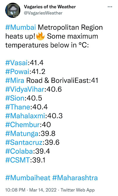
14th March Mumbai Regional Highs
Vagaries© of the weather.blog written by rajesh kapadia & co-authors concentrating on meteorology of the Indian sub continent and extreme world weather since 55 years For Any Information taken from here, due credit must be given to Vagaries.
Co Authors: GSB, Shreyas Dhavale, Pradeep John, Dr. Vineet Singh, Gokul
Monday, March 14, 2022
Subscribe to:
Post Comments (Atom)
1st January 2026 ... Mumbai starts new year with Inaugural Rains..several parts get early morning showers

-
Much Awaited Monsoon Analysis to Date from ..None Other than Our GSB..on "Stats and Analysis" Page..Just Recieved On Saturday ...
-
Short Narration: Monday 1st/Tuesday 2nd : The heaviest rains are in Madhya Maharashtra, Marathwada, North Interior Karnataka and No...


1 comment:
Credit Australian Government Bureau of metereology latest issued 15 03 2022
Issued 15 March 2022
The latest Climate Driver Update and Climate Model Summary are now available on the Bureau's website.
La Niña retreat stalls as trade winds strengthen
The 2021–22 La Niña event continues but is past its peak. However, trade winds remain stronger than average in the western Pacific, which has delayed further weakening of the La Niña over the past fortnight. Latest outlooks indicate a return to neutral El Niño–Southern Oscillation (ENSO) levels—neither La Niña nor El Niño—late in the southern hemisphere autumn. Even as La Niña weakens, it will continue to influence global weather and climate.
Atmospheric and oceanic indicators over the Pacific persist at La Niña levels. Persistently strong trade winds over the past fortnight have driven a cooling to La Niña levels of the central tropical Pacific. This has also cooled water beneath the surface, pausing the warming trend seen during January and February. Warming below the surface of the Pacific Ocean typically foreshadows a breakdown in La Niña, and usually occurs in the southern hemisphere autumn. In the atmosphere, indicators largely remain at La Niña levels, with decreased cloudiness along the Date Line, strengthened trade winds in the western Pacific, and a positive Southern Oscillation Index (SOI).
La Niña events increase the likelihood of tropical cyclones within the Australian region, as well as increasing the chances of above average rainfall across large parts of eastern Australia during autumn.
A pulse of the Madden–Julian Oscillation (MJO) is strengthening over the Indian Ocean. Most climate models suggest the MJO is likely to move into the western Maritime Continent region, to Australia's north, in the coming week. Typically, when the MJO is in the Maritime Continent, there is an increased likelihood of above-average cloudiness and rainfall across northern Australia and the islands to our north. The risk of tropical cyclone development is also expected to be elevated across parts of northern Australia and the tropical South Indian Ocean in the coming fortnight.
The Southern Annular Mode (SAM) is currently neutral. It is forecast to remain neutral over the coming three weeks. A neutral SAM has little influence on Australian climate.
The Indian Ocean Dipole (IOD) is neutral. It typically has little influence on global climate from December to April due to the influence of the monsoon. Outlooks for the IOD indicate a neutral IOD is most likely for the remainder of autumn. Model outlooks have low accuracy beyond this time.
Climate change continues to influence Australian and global climate. Australia's climate has warmed by around 1.47 °C for the 1910–2020 period. Rainfall across northern Australia during its wet season (October–April) has increased since the late 1990s. In recent decades there has been a trend towards a greater proportion of rainfall from high intensity short duration rainfall events, especially across northern Australia.
More information
Media enquiries: (03) 9669 4057 media@bom.gov.au
Next update expected on 29 March 20
Post a Comment