Maharashtra/Mumbai Outlook for next week 28th February - 3rd March.
Mumbai:
Gradual diminishing of the "winter nip" Of the last few weeks. Days getting warmer to 34/35c ( currently 30/32c).
Nights not yet getting stuffy or warm as it may hover around 21/23c.
Low humidity and low sweat conditions will be the added advantage yet.
Pune: Days are warm today at 35c..will see next week slightly warmer days now onwards around 37c. Nights pleasant still to remain comfortable around 18/19c.
Interior Konkan, (Karjat, Bhira, Badlapur Thane) where there are AWS & "part time" Weather Stations ( Non IMD), days next week may shoot to touch 40/42c.
Rest Maharashtra will be warming up, specially Vidharbh. ( 35/38c)
All of Gujarat, and more South Gujarat coast may see some 2/3c rise in next week.
Bharuch expected to reach 40c coming week.
Other weather Outlook:
Quick snippets:
NCMRWF forecast for next week ⬇⬇⬇
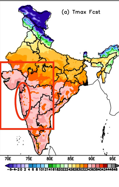
Gujarat, Maharashtra and peninsular India (N.I.Karnatak )warming up gradually. ... 35/38c.
A low pressure area BB-2 is likely to form in the Bay of Bengal by March 1 and move in a northwest direction towards Tamil Nadu coast. Parts of coastal Tamil Nadu can get some rain during 3-4 March.
A weak WD will affect western Himalayas during 2-3 March.
Assisted by Vagarian Shreyas.


1 comment:
Credit Australian Government Bureau of metereology latest issued 01 03 2022
Issued 1 March 2022
The latest Climate Driver Update and Climate Model Summary are now available on the Bureau's website.
La Niña to persist until mid-autumn
The 2021–22 La Niña is past its peak, with outlooks indicating a return to neutral El Niño–Southern Oscillation (ENSO) levels—neither La Niña nor El Niño—during the southern hemisphere autumn. As La Niña weakens, it will continue to influence global weather and climate.
Atmospheric and oceanic indicators over the Pacific remain at La Niña levels. Eastern tropical Pacific sea surface temperatures remain cooler than average despite a slow warming of deeper waters. Warming below the surface of the Pacific Ocean typically foreshadows a breakdown in La Niña, and typically occurs in the southern autumn. In the atmosphere, several indicators remain at La Niña levels, including decreased cloudiness along the Date Line, strengthened trade winds in the western Pacific, and a positive Southern Oscillation Index (SOI).
La Niña increases the likelihood of tropical cyclones within the Australian region, as well as increasing the chances of above average rainfall across large parts of eastern Australia during autumn.
The Madden–Julian Oscillation (MJO) recently weakened while in the Australian region and is now indiscernible. Most climate models suggest the MJO is likely to remain weak for the coming fortnight, meaning it is unlikely to influence tropical climate during this time.
The Southern Annular Mode (SAM) is neutral and is forecast to remain neutral over the coming three weeks. A neutral SAM has little influence on Australian climate.
The Indian Ocean Dipole (IOD) is neutral. It typically has little influence on global climate from December to April due to the influence of the monsoon.
Climate change continues to influence Australian and global climate. Australia's climate has warmed by around 1.47 °C for the 1910–2020 period. Rainfall across northern Australia during its wet season (October–April) has increased since the late 1990s. In recent decades there has been a trend towards a greater proportion of rainfall from high intensity short duration rainfall events, especially across northern Australia.
More information
Media enquiries: (03) 9669 4057 media@bom.gov.au
Next update expected on 15 March 2022
Post a Comment