Pakistan Update on Vagaries Pakistan..Updating India Weather here tonight.
All 50 U.S. states feel freezing temperatures, four dead in New York...Including Hawaii...Full Details here
Mumbai was hot at 35.8c (Scruz) and 35.3c at Colaba.
Thursday will be hot at 35c. Hazy skies .
Thursday:
Showers in South TN and Southern Kerala. Dry weather in rest of India.
Weekend Forecast coming up on Friday Night.
Seasons of Indian Air Quality:
The skies over the Indo-Gangetic Plain—a river valley that includes parts of Pakistan, India, Nepal, and Bangladesh—are among the haziest in the world. Those four countries regularly come in near the bottom of annual rankings for air quality. In 2014, the World Health Organization listed Delhi as the city with the most polluted air in the world.
However, such rankings do not properly reflect the complexity and variability of the region’s air, said Hiren Jethva, a scientist at NASA’s Goddard Space Flight Center. “Air pollution is a real and growing concern over certain cities, but too often people generalize and assume the entire region is constantly blanketed by thick, gray industrial pollution.”
Indeed, the Indo-Gangetic Plain is remarkable for how much air quality varies throughout the year. This set of images from the Moderate Resolution Imaging Spectroradiometer (MODIS) on NASA’s Aqua satellite helps illustrate the range of factors—some natural, some not—that contribute to the variation.
The main types of airborne particles, or aerosols, that affect visibility over the Indo-Gangetic Plain are dust, organic carbon, black carbon, sulfates, and nitrates. Sand storms in the Thar Desert loft most of the dust. Agricultural fires in the western part of the Indo-Gangetic Plain and forest fires in the eastern part produce significant amounts of organic carbon; so do the many wood stoves and cooking stoves throughout the region. Millions of automobiles, power plants, incinerators, smelters, and other industrial sites in urban areas are prolific producers of sulfates, nitrates, and black carbon.
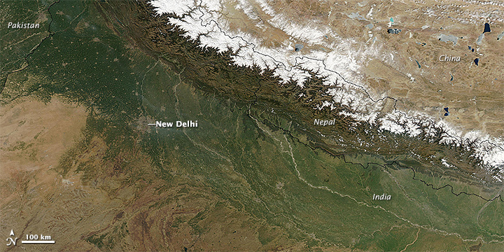
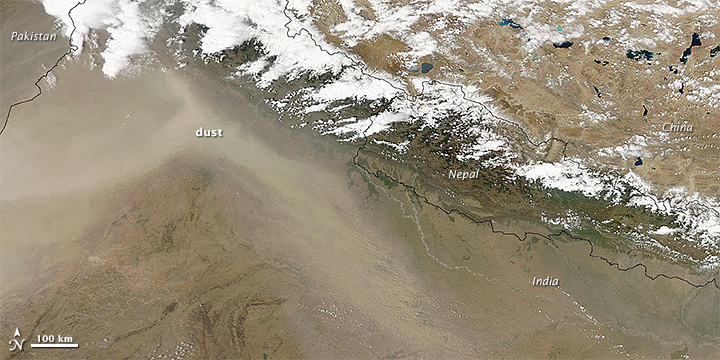
The abundance and proportion of these aerosols vary throughout the year. Spring brings the clearest skies of the year. When MODIS captured the top image on March 9, 2010, skies were clear enough to pick out cities such as New Delhi amidst the green background of farms. As spring progresses, dust increasingly fills the air and comes to dominate by mid summer. The second image shows just such a dust storm obscuring most land features in April 2010.
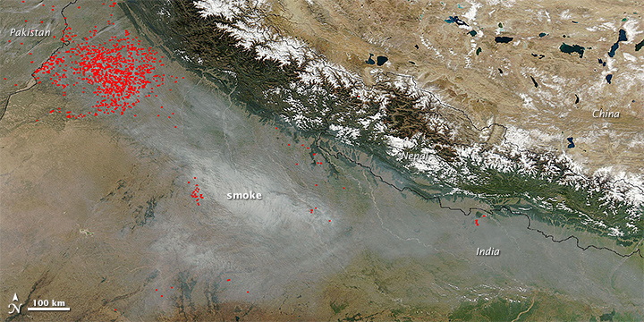
After the rains of the summer monsoon clear the dust, the composition of the air shifts in the fall crop-burning season (October and November) for farmers, particularly in the northwestern Indian states of Punjab and Haryana. When MODIS passed over on November 4, 2010, the sensor observed numerous small fires and a large smoke plume lingering downwind.
“In the fall, we start to see a decrease in coarse dust particles and a real jump in the abundance of the finer particles that predominate in smoke and industrial pollution,” said Ritesh Gautam, an aerosol specialist at the Indian Institute of Technology.
The cool months of December and January are best known for producing thick fogs and aerosols hazes. Cooking and heating stoves in rural areas add smoke; so do a smattering of agricultural fires that continue through the winter. Urban areas contribute nitrates and sulfates that come from vehicles, coal-fired power plants, and other industrial sources.
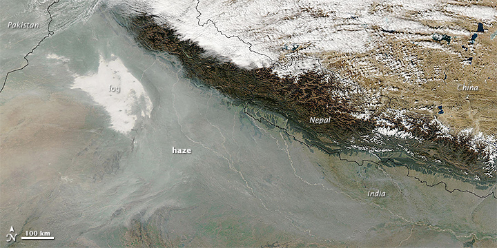
As seen by MODIS image on December 26, 2010, most overnight fog burns off in the morning but leaves some patches of fog amidst an aerosol haze. These fog and aerosol hazes likely amplify each other. On one hand, aerosol particles serve as “seeds” that make it easier for fog and clouds to form. On the other, fog droplets accelerate the conversion of gaseous pollutants into haze-causing aerosols. Damp conditions also amplify haze because high humidity increases the size of many aerosols, making them more likely to block light.
“The other piece to keep in mind if you want to understand why this part of the world has such a problem with air quality is its unique geography,” said Gautam. “Air masses get hemmed in by the Himalayan mountains in the north and the Vindhya mountains in the south. When temperature inversions occur, all the smoke, dust, and industrial pollution entering the atmosphere ends up piling up over the Indo-Gangetic plain because it can not get over the mountains.”
Earth Obseravtory.


3 comments:
very nice and informative article....clearly tells the reasons of high AQI over northern plains...its more of geographical and natural factors, not just because of generally perceived industrial pollution.
Sir I am vising uttrakhand in village from 23- 26 nov. The location is near devprayag in pauri garhwal district . The elevation is about 1200- 1300m . Sir will there be any significant weather during this time. Will there be very cold?
Anoop: sorry for last minute reply...do not see any adverse or rough weather in Uttarakhand during your stay. Could be cold as we expect a WD on 25th in Kashmir...
Post a Comment