25th September Evening Post:
South West Monsoon likely to bid goodbye from Punjab, Haryana, Delhi and Rajasthan by Thursday 29th/ Friday 30th September.
Now, rain activities will reduce significantly over Northwest India including Punjab Haryana Delhi and western parts of Uttar Pradesh.
An anticyclone is expected to develop over southwest Rajasthan by September 27, and northwesterly dry winds will commence over most parts of Northwest and Central India.
Seasonal Rainfall (in mm) since 01 June 2022 till 25 September 2022 EAST & NORTHEAST INDIA -17% ,
NORTHWEST INDIA +1%
CENTRAL INDIA +19%
SOUTH PENINSULA INDIA +24%
COUNTRY AS A WHOLE 909.3 mms (Actual) .. 848.5mms ( Normal) +7%
Currently, the Country as a whole is in Surplus by +7%.
But N.E, Jharkhand and U.P.are in deficit. These states can recover if the UAC in West Bay tracks N/NW...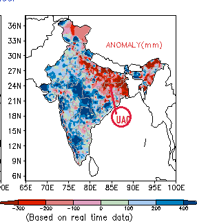
Navratri Forecasts for first 5 days:
Mumbai: From 26th thru 29th,. Celebrating Navratri Garba will be .with few showers in certain areas, but hopefully without major rain interruptions and without hindrance.
30th onwards, will review if thundershowers can occur.
Pune: Pune can get the evening thunderstorms from 27th or 28th thru the week.
Aurangabad District. From 27th/28th/29th, can get moderate to heavy thundershowers in pockets. Some patches may see hit or miss. Thundershowers can occur thru till Friday.
औरंगाबाद जिल्हा. 27/28/29 पासून, अनेक ठिकाणी मध्यम ते जोरदार पाऊस पडू शकतो. शुक्रवारपर्यंत मेघगर्जनेसह पाऊस पडू शकतो.Gujarat: The first 5 days of Navratri Celebrations will be rain free in Saurashtra.
However, some patchy showers can be expected in Gujarat Region. Bharuch, Surat on 27th,/28th.


2 comments:
Heat wave south east India tamilnadu and south andhra 38-49c. When will northeast monsoon start?
Credit Australian government Bureau of metereology
Issued 27 September 2022
The latest Climate Driver Update and Climate Model Summary are now available on the Bureau's website.
La Niña under way in the tropical Pacific
La Niña is underway in the tropical Pacific and the Bureau's ENSO Outlook remains at LA NIÑA.
La Niña increases the chance of above average rainfall for northern and eastern Australia during spring and summer.
Both atmospheric and oceanic indicators of the El Niño–Southern Oscillation (ENSO) are consistent with an established La Niña, including tropical Pacific sea surface temperatures, the Southern Oscillation Index (SOI), trade wind strength, and equatorial cloudiness.
Models indicate the La Niña may peak during spring and return to neutral conditions early in 2023. Sea surface temperatures in the tropical Pacific have weakened a little compared to two weeks ago while the SOI has continued to rise and is currently well above La Niña thresholds.
The negative Indian Ocean Dipole (IOD) event continues. The IOD index has satisfied negative IOD thresholds (i.e. at or below −0.4 °C) since June. Models indicate that the negative IOD is likely to persist at least until late spring. A negative IOD typically increases the chance of above average spring rainfall for most of the eastern two thirds of Australia.
When La Niña and negative IOD conditions combine, the likelihood of above average rainfall over Australia is further increased, particularly for the eastern half of the continent.
The Southern Annular Mode (SAM) is currently positive and is likely to remain generally positive throughout spring into early summer. During the spring months, positive SAM increases the chance of above average rainfall for parts of eastern New South Wales, eastern Victoria, and south-eastern Queensland, but has a drying influence for western Tasmania.
Most models indicate the Madden–Julian Oscillation (MJO) will strengthen over the Maritime Continent in the coming week and maintain moderate strength as it moves east towards the western Pacific. While active in the Pacific at this time of the year, the MJO increases the chance of above average rainfall over the eastern half of Australia.
Climate change continues to influence Australian and global climate. Australia's climate has warmed by around 1.47 °C for the 1910–2020 period. There has also been a trend towards a greater proportion of rainfall from high intensity short duration rainfall events, especially across northern Australia.
ENSO Outlook
Our ENSO Outlook provides
up-to-date information on the likelihood of an El Niño or La Niña developing.
Current status: LA NIÑA
More information:
Media enquiries: (03) 9669 4057 media@bom.gov.au
Next update expected on 11 October 2022
Post a Comment