Co Authors: GSB, Shreyas Dhavale, Pradeep John, Dr. Vineet Singh, Gokul

Wednesday, March 11, 2015

El Nino....Likely This Year ? El Niño forecast indicates brightening chances of El Niño forming after June  2015.

The central to western regions of the tropical Pacific Ocean have warmed by 0.2 °C to 0.3 °C over the past fortnight, while monthly sub-surface temperatures were more than 2 °C above average over a large area for February. This is largely the result of weakened trade winds and tropical surface currents in recent weeks.

Warmer-than-average temperatures in the tropical Pacific Ocean and models indicate that further warming is likely in coming months. 

Weakened trade winds are forecast to continue, and this may induce further warming.
All international models  indicate that central tropical Pacific sea surface temperatures (SSTs) are likely to remain warmer than average, but within the neutral range, until at least May. 


indications point that SSTs will exceed El Niño thresholds. 


The most recent Southern Oscillation Index (SOI) value is −0.5 to 8 March 2015, and the latest sea surface temperature anomaly in the central Pacific (NINO3.4 region) is +0.5 °C. 

Sustained positive values of the SOI above +8 may indicate La Niña, while sustained negative values below −8 may indicate El Niño. Values of between about +8 and −8 generally indicate neutral conditions.

There is evidence that the MJO influences the ENSO cycle. It does not cause El Niño or La Niña, but can contribute to the speed of development and intensity of El Niño and La Niña episodes.
Overall, the MJO tends to be most active during ENSO neutral years, and is often absent during moderate-to-strong El Niño and La Niña events. The MJO activity during late 2007 and early 2008, which occurred during La Niña conditions, is unusual but not
unprecedented.


No strong MJO seen till mid April in our seas ( North Indian Ocean).
Excerpts from Aust.Bur of Met

 ************************************


Maharashtra continues to get rains, ending 8.30 am on 12.03.2015

The trough at mean sea level from Lakshadweep area to north Konkan now extends from Lakshadweep area to Gujarat region across coa stal areas of Karnataka and Maharashtra.

in mm (min 25 mm)

Anturli - 59
Akole - 55
Patur - 46
Vihigaon - 41
Alegaon - 40
Pachgani - 39
Dhad - 38
Amalner - 37
Ambegaon - 37
Manikodh - 35
Jawala - 35
Dhaba - 35
Amalgaon - 35
Chowka - 35
Sasti - 34
Bharwas - 34
Khaknar - 32
Shirud - 32
Agar - 31
Jalgaonamod - 30
Channi - 30
Wazar - 30
Umara - 30
Kalegaon - 29
Medshi - 29
Sanglud - 29
Sawalikheda - 28
Wadner - 28
Wadshingi - 28
Babhulgaon - 28
Wawade - 28
Khadkwasla - 27
Dhanora - 27
Akolkhed - 27
Adgaon - 26
Kalmodi - 26
Wyala - 26
Akot - 26
Pimpalgaon - 25
Ansing - 25
Kapustalani - 25
Pankanhergaon - 25
Shelu - 25
Anjangaon - 25
Jafrabad - 25
Shiravali - 25
Madh - 25
Moleshwari - 25
Raver - 25

Vagaries Rainman 

Tuesday, March 10, 2015


Maharashtra is getting rains, while entire country is dry, ending 8.30 am on 11.03.2015

The trough of low at mean sea level  from  Lakshadweep  area  to  south  Madhya  Maharashtra  now  extends  from  Lakshadweep  area  to  north  Konkan  across  coastal
Karnataka.

in mm (min 30 mm)

Kundal - 73
Kasari - 60
Yelavi - 60
Pendgaon - 52
Morigiri - 51
Shalgaon - 48
Kolgoan - 46
Marali - 44
Saswad - 44
Borivade - 44
Pimpalgaon - 44
Khanapur - 42
Wangi - 42
Goregaon - 42
Tarali - 41
Supane - 41
Waduj - 41
Bembali - 40
Kirloskarwadi - 37
Palus - 37
Mhalasjawala - 36
Chandoh - 35
Umbraj - 34
Chichondi - 34
Madha - 34
Upshinghe - 33
Kale - 32
Pusesavali - 32
Channi - 32
Wathar - 30
Sonat - 30
Temghar  - 30
Yelgaon - 30
KoparadeHaveli - 30
Tasgaon - 30
Mungala - 30
Muthe - 30
Kumbharwalan - 30
Maulagi - 30
Sasawad - 30
Lokhandi - 30

Monday, March 09, 2015

Thunder showers expected in Muscat on Wednesday 11th night.Cold day on Thursday at 22/23c as maximum...

Mumbai:
Tuesday 10th: Sunny with few clouds. High around 34c. 
Wednesday 11th: Partly Cloudy with day around 33/34c. Light rain in evening in some parts.
Thursday 12th: Partly Cloudy with light rains in parts of City. By evening rain measured maybe upto 5 mms.

Pune : Tuesday and Wednesday: Partly cloudy with light to medium showers. Day around 31c. With rain about 3-5 mms /day.
The forecasted showers in Pune on Tuesday afternoon....sent by Cmdr Potey...


Aurangabad:
Tuesday 10th: Partly cloudy, getting totally cloudy by evening. Some light showers in afternoon and evening, with day temperature around 30/31c. Would expect around 3 mms/
Wednesday 11th: Cloudy with showers in the day. Around 5 mms in the day, and a few medium showers by evening/night.
Thursday 12th: Rains decrease.
Friday 13th: Heavy showers expected in many regions and parts of city.

Akola Region
Tuesday 10th and Wednesday 11th will be cloudy with medium rains in most parts of region. 
Thursday 12th: A slight decrease in rains, only to increase on Friday 13th.

New Delhi NCR: Tuesday 10th/Wednesday 11th/Thursday 12th will be cloudy. Days hovering around 30c. Rains commencing on Friday 13th.

Kolkata: Warm...or hot ! get ready for 35c next few days.


Widespread Rains continue in Karnataka, ending 8.30 am on 10.03.2015

A trough at mean sea level extends from Lakshadweep area to south Madhya Maharashtra across coastal & north interior Karnataka.

in mm (min 25 mm)

Yemmedoddi - 96
Shahpur - 76
Gududar - 64
Nesargi - 64
Dharwad Hos - 51
Uppinangady - 50
Bhagavathi - 49
Dharwad - 48
Kurugodu - 47
Hethur - 45
Katageri - 44
Kulageri Cross - 42
Sutagatti - 40
Katkol - 38
Soundathi - 36
Deodurg - 40
Havangi - 34
Talaguppa - 32
Thogarsi - 32
Nalwar - 32
Kurikuppa - 32
Vijaypura - 31
Bailhongal - 30
Kerur - 30
Pradhani - 28
Devihosur - 28
Sedam - 28
Tigadi - 28
Bheemarayangudi - 26
Tilavalli - 26
Udevu - 26
Haveri - 26
Hulikatti - 25
Tadas - 25
Hirebagewadi - 25
Sukravarsanthe - 25
Yergatti - 25
Ajekar - 25
Sammasgi - 25

2nd day of rains in Maharashtra, ending 8.30 am on 10.03.2015

A trough ( LWD mentioned in 6th March Post) at mean sea level extends from Lakshadweep area to south Madhya Maharashtra across coastal & north interior Karnataka.

in mm (min 20 mm)

Manora - 78
Nagthana - 57
Kondhala - 45
Pardi Takmor - 42
Pendgaon - 41
Dhapewada - 40
Pardi Aasare - 35
Goregaon - 34
Washim -34
Kekatumara - 32
Mangarulpir - 31
Mohpa - 31
Aasegaon - 30
Ansing - 30
Aundha - 28
Kondhali - 27
Shelu - 27
Poti - 26
Kauthal - 26
Kolha - 26
Rithad - 26
Vairag - 26o
Vita - 25
Visapur - 25
Nevari - 25
Bambhora - 24
Inzhori - 24
Dhanora - 24
Kalemeshwer - 23
Semadoh - 23
Darvha - 22
Bhar - 21
Rajgaon - 20
Lawul - 20
Kupata - 20
Amaravati - 20
Sindkhedraja - 20
Nawasari - 20
Talegaon - 20
Soegaon - 20
Shrigonda - 20
Karjat - 20
Giroli - 20
Yelavi - 20
Diganchi - 20

Moderate rains in Telangana, ending 8.30 am on 10.03.2015

A trough at mean sea level extends from Lakshadweep area to south Madhya Maharashtra across coastal & north interior Karnataka.

in mm (min 5 mm)

Mahabubabad - 71
Tandur -  41
Peddemul - 35
Malyal - 27
Bhiknur - 16
Navangidi - 15
Malchelma - 11
Domakonda - 11
Bijwar - 10
Chinnajatram - 8
Mominpet - 8
Gangadhara - 7
Dharur - 7
Utkoor - 7
Yellandu - 7
Marpalle - 6
Gundlamachanur -6
Vikarabad - 6
Bayyaram - 6
Bodhan - 5
Zaffergadh - 5
Gundamal - 5
Lingaipalle - 5
Madanpalle - 5
Makthal - 5
Maganoor - 5
Bomraspeta - 5

Moderate rains in Kerala, ending 8.30 am on 10.03.2015

A trough at mean sea level extends from Lakshadweep area to south Madhya Maharashtra across coastal & north interior Karnataka.

in mm (min 5 mm)

Kayamkulam - 68
Thariode - 25
Mavelikkara - 25
Kuppady - 24
Nedumangad - 23
Kollengode - 18
Irikkur - 18
Taliparamba - 18
Thenmala - 15
Vadakara - 13
Chittur - 11
Anchal - 10
Kurudamannil - 8
Thalassery - 8
Haripad - 7
Kuttiyady - 5
Meenagadi - 5
Chengannur - 5

Maharashtra gets renewed spell of rains from LWD, ending 8.30 am 09.03.2015

The trough / wind discontinuity in the lower levels now extends from Lakshadweep area to east Madhya Pradesh across north interior Karnataka and interior Maharashtra

in mm (min 10 mm)

Gosikhurd - 57
Patan - 41
Joiti - 39
Korpana - 37
Dudhani - 34
Akkalkot - 28
Chatgaon - 28
Pench Asolamendha - 27
Udgir - 21
Hanegaon - 20
Markhel - 18
Malegaon - 18
Pendhari - 16
Borol - 15
Sagroli - 15
Aheri - 15
Erai - 14
Desaiganj - 12
Bhamaragad - 12
Murumgaon - 11
Shankarpur - 11
Mulchera - 10
Kini - 10
Kundalwadi - 10
Wadsa - 10
Dewani - 10
Deoni -10
Mukramabad - 10
Ashti - 10
Wadner  - 10
Gadchiroli - 10
Brahamani - 10
Mohali - 10

Himachal gets next Spell of rains from WD, ending 8.30 am on 09.03.2015

Western Disturbance as an upper air cyclonic circulation lies over north Pakistan and adjoining  Jammu  & Kashmir  and extends upto mid tropospheric levels with a trough aloft runs roughly along Long. 72°E and north of Lat 25°N.

in mm (min 20 mm)

Jubbal - 65
Kheri- 51
Chamba - 43
Rampur - 43
Udaipur - 43
Seobagh - 36
Kangra - 35
Gaggal - 35
Bhuntar - 35
Arki - 35
Mehre - 32
Nagrota Suriyan - 32
Gohar - 32
Rohru -32
Solan - 31
Dharamshala - 31
Bajaura - 31
Banjar - 30
Joginder Nagar - 30
Rajgarh - 30
Harimpur - 28
Kandhaghat - 25
Sundernagar - 25
Annu - 25
Shahpur - 25
Mandi - 24
Kalatop - 21
Shimla - 20
Palampur - 20
Bilaspur - 20

Karnataka gets Widespread heavy rains due to LWD, ending 8.30 am 09.03.2015

The trough / wind discontinuity in the lower levels now extends from Lakshadweep area to east Madhya Pradesh across north interior Karnataka and interior Maharashtra

in mm (min 35 mm)

Javagal - 192
Kiraganduru - 116
Dharwad HOS - 93
Suntnoor - 86
Koppa - 84
Hiremaralihalli - 77
Bidar - 72
Bidar PTO - 69
Vastare - 67
Dharmasthala - 67
Ramapura - 66
Agumbe - 65
Annigere - 62
Bellatti - 61
Belur - 60
Bikkodu - 56
Dummawad - 55
Jayapura C - 53
Chickmagalur - 53
Abbigere - 51
Nagenahalli - 47
Bennihalli - 47
Kadaba - 45
Mundwad - 43
Dundasi - 43
Kannangi - 45
Kalaburgi - 40
Hospet - 40
Laxmeshwar - 39
Banavara - 39
Dharawad - 38
Hosaritti - 38
Eedu - 37
Bankapur - 37
Savanur - 37
Amminabhavi - 36
Gulbarga - 36
Kanguvalli - 36
Janwada - 35
Idagundi - 35
Nagnur Byaraj - 35
Nimberga - 35


Widespread heavy rains in Telangana due to LWD, ending 8.30 am 09.03.2015

The trough / wind discontinuity in the lower levels now extends from Lakshadweep area to east Madhya Pradesh across north interior Karnataka and interior Maharashtra

in mm (min 40 mm)

Sirpur - 84
Madanpalle - 78
Vikarabad - 72
Bantaram -71
Bollaram Patti - 70
Hathnoora - 69
Marpalle - 68
Malchelma - 64
Mominpet - 63
Birkoor - 60
Kosgi - 58
GundlaMachanur - 58
Peddemul - 57
Almaipet - 51
Tandur - 51
Kandi -50
Banswada - 49
Sadasivanagar - 47
Nathinoipalle - 46
Medak - 44
Dharur - 44
Sanrangapur - 43
Jharasangam - 43
Peddemul - 42
Jukkal- 41
Pulkal - 40
Manoor - 40
Meerkhanpet - 40
Minipur - 40
Digwal - 40
Nyalkal     - 40
Naggareddipet - 40


Fresh Spell of heavy rains in Kashmir from WD, ending 8.30 am on 09.03.2015

Western Disturbance as an upper air cyclonic circulation lies over north Pakistan and adjoining  Jammu  & Kashmir  and extends upto mid tropospheric levels with a trough aloft runs roughly along Long. 72°E and north of Lat 25°N.

in mm (min 10 mm)

Shalimar - 99
Srinagar IAF - 78
Pahalgam - 72
Banihal - 72
Batote - 66
Bhaderwah - 54
Srinagar - 54
Quazigund - 52
Kukernag - 50
Gulmarg - 40
Baramullah - 19
Kawa - 17
Katra - 14
Jammu - 12

Sunday, March 08, 2015

Breaking News - Only for Vagaries from Pradeep John, our Rainman, - will furnish all rainfall details as it is happening. No need to wait for IMD Mumbai Report for rain. Significant rainfall will be reported first here in Vagaries.


Flash Floods in Coonoor as heavy rains lash at mid-night, ending 8.30 am on 08.03.2015 


A trough / wind discontinuity in the lower levels runs from Lakshadweep area to west Madhya Pradesh across coastal & north interior Karnataka and interior Maharashtra.

in mm (min 5mm)

Coonoor PTO - 125
Coonoor - 88
Ooty Agro - 38
Buraliar - 20
Ketti - 18
Ayikudi - 15
Pillur - 15
Kothagiri - 13    
Tirupattur - 12
Kodhai - 12
Pegumbahallah - 12
Thenkasi - 10
Porthimund - 10
Periyakulam - 10
Sivagiri - 9
Parsons Valley - 8
Bodinaickanur - 8
Uthagamandalam - 8
Kundha Bridge - 7 
Upper Bhavani - 7
Emerland - 7
Avalanche - 6
Andipatti - 6
Kodaikanal - 5
Servalar - 5


Vagaries Rainman 


Margala Hills of Islamabad got snowfall today... very very rare happening in month of March... further Murree got 12 inches of snowfall in last 36 hours... its also rare for these days of season....Islamabad saw a high of 14.5c.
Pic from islamabad !!..

.Report and Pic sent by Waqas from Islamabad.

Total rain in Delhi this march...
Palam: 102.9 mm
Safdarjung: 81.6 mm..Thanks Arpit

Friday, March 06, 2015

Srinagar measured 36 mms on Sunday and 10 mms on Saturday..46 mms in last 2 days.Day's high was 3.4c.

Saturday 7th: Gujrat City in Pak saw a max of 15.5c on Saturday (Vagaries' estimate was 18c), and 22 mms against forecasted 20-25 mms. Islamabad saw 28 mms on Saturday, with another 7 mms on Sundayagainst estimated 50-55 mms for Sat and Sun combined.Karachi had no rains.

Delhi Sjung measured 14 mms and Palam 19 mms. Meerut 17 mms and Hindon 8.6 mms. Some Northern parts had no rainfall.
Thunder Storm with very Gusty winds in many parts of Delhi NCR on Saturday Evening...

For Aurangabad Readers; (Vagaries column in Lokmat Times Sunday)
"Weather Watch
March seems to be getting off to a wet start ! Already last week's rains are keeping the day temperatures below the normal for this time of the year.
Another spell of rains coming ....and Aurangabad will be getting another rain spell on Monday 9th March. This time, the rains will be persisting till Wednesday. Cool and cloudy days will be the start of next week.Wednesday will be cool. Would expect around 15-20 mms in 3 days of rainfall.
But, surely it will be not so good news for the farmers. The standing wheat crops in the fields are recommneded to be left uncut. The cutting and harvesting would be damagaing as it would be difficult to keep the cut product dry. However, the harvested wheat needs to be kept safe. The mango flowers and raw fruits would see further damage and rotting. It would be a severe damage if the rains persist as expected. All other crops should be left un cut and safe in fields as exposing them would be damaging." (See Vagaries' Aurangabad Forecast here...Page 2
http://epaper.lokmat.com/lokmattimes/epapermain.aspx?queryed=78)

Vagaries' mentioned LWD rain continues in Karnataka, ending 8.30 am on 08.03.2015 

The mentioned trough / wind discontinuity in Vagaries in the lower levels runs from Lakshadweep area to west Madhya Pradesh across coastal & north interior Karnataka and interior Maharashtra.
   
in mm (min 15 mm)

Doddabygathavalli - 72
Ganjalagodu - 72
Mushigeri - 53
Dundalli - 53
Arasalu - 44
Arkalgud - 41
Kondaguli - 40
Yalawar - 40
Belagatta - 35
Dudda - 34
Halekote - 33
Honnahalli - 31
Bindiganavole - 31
Turuvanur - 30
Kerehalli - 30
Koradakera - 29
Shirahatti - 29
S.Bidare - 29
Magadipalya - 27
Madraki - 27
Gorur - 26
Koyyuru - 25
Roudalabanda - 25
Ainolli - 23
Madgal - 23
Kudatini - 21
Marola - 21
Bendaganavele - 18
Deodurg - 17
Kaggere - 16
Dharmasthala - 16
Bhimalkhed - 16
Udabanalli - 15
Boodigere - 15
Kottigehara - 15
Tyagadabaji - 15
Madapura - 15
Basarikatte - 15

Vagaries Rainman

Posted Friday 6th March Noon (IST):

The expected Western Disturbance M-2 Moves into Pakistan from the West on Saturday 7th. A deep trough at 200 hpa level, and an induced Low over Punjab at Sea level brings Rainfall spreading from Balochistan into Pak Punjab by evening.

Sunday sees the WD continue to bring good precipitations to North Pakistan (Punjab) and move into Northern and NW India. Islamabad will see a wet weekend, thunder showers pouring around 50-55 mms this weekend. Saturday and Sunday.
Gujrat City in Pak Punjab can expect 20-25 mms. Cool Saturday at 18c Max. . 
Karachi: Cloudy on Saturday with light drizzles in parts of City. North winds dominate.

Rains possible on Sunday 8th  in Kashmir, HP, Punjab and Haryana and Northern Rajasthan. 
Sunday evening showers possible in N.I. Karnatak (Belgaum) and adjoining Southern regions of Maharastra.

Late Sunday Night and early Monday 9th morning we see heavy rains in some parts of Pak Punjab (Gujrat City) and adjoining Western parts of Indian Punjab.
Due to the LWD of North Winds from the WD and South/South East winds over Maharshtra,  rains increase in Maharashtra from Sunday night to move into Marathwada (Aurangabad) and  Vidharbha(Akola and Nagpur).


Heavy spells in parts of both Punjabs on Monday 9th. 
Showers on 9th Monday pop up  in Marathwada and Vidharbha. Some regions of Madhya Maharashtra, specially north get heavy showers. Possible to see some showers drift into Interior Central Konkan areas ( Roha, Panvel).

Cities Estimate till Monday 9th:
Mumbai: May not see much clouding or rainfall till Wednesday. Weekend and into Monday, the day temperatures will rise to reach 32c, and nights may go up to 21c (from current range of 30c_ 16c at Santa Cruz).

New Delhi: Weekend till Monday, partly cloudy, with stray shower in some parts of NCR on Saturday/Sunday. Gusty S/SE winds. Otherwise, day will be at 28c.

Pune: As the day becomes warm this Sat/Sund at 33c, thunder showers in some parts will cool the city on Monday 9th evening. Rains on Tuesday also. 

Belgaum: Showers from Sunday night into Monday.

Akola: The region will see a warm weekend with days possibly rising to 33/34c. But light showers on Sunday evening, and light rains on Monday will cool the atmosphere on Monday. Would expect around 5-7 mms rains from sunday night to Monday night. More rains  and cloudy next week.

Nagpur: Aftre a warm partly cloudy weekend, a thundershower possible on Sunday night. Maybe around 10 mms till Monday morning.

Surat and Bharuch will be warm or hot. Possible showers by mid next week.

================================

Moderate Rains in Tamil Nadu, ending 8.30 am on 07.03.2015

The upper air cyclonic circulation over Lakshadweep and adjoining Maldives area extending upto 0.9 km above mean sea level persists.

in mm (min 5 mm)

Devala - 52
Anjatti - 30
Hogenekal - 30
Pennagaram - 25
Hosur - 25
Coimbatore AP - 20
Periakulam - 20
Kulasekahram - 18
Lower Nirar - 14
Dekanikottai - 14
Valparai - 14
Chinnakalar - 13
Thalavadi - 10
Eraniel - 10
Uthagamandalam - 9
Bodi - 9
Theni - 8
Pechiparai - 7
Yelagiri - 7
Munchirai - 7
Porthimund - 7
Jolarpet - 6
Manjalar - 5

Interior Karnataka continues to get widespread rain, ending 8.30 am on 07.03.2015

The upper air cyclonic circulation over Lakshadweep and adjoining Maldives area extending upto 0.9 km above mean sea level persists.

in mm (min 25 mm)

K.Shettihalli - 80
Salagame - 65
Markandeyanakere - 64
Udbooru - 63
Nariyandada - 62
Gullahalli - 59
Malur - 56
Dugnoor - 52
Palya - 50
Arebommanahalli - 49
Chimkod - 49
Jayapura - 47
Somayajalpalli - 45
Mudabalu - 44
Badavanahalli - 35
Badanaguppe - 35
Bagur - 34
Mysuru - 33
Nanjangud - 33
Anekal - 31
Huliyurdurga - 31
Midigeshi - 30
Ramanagara - 30
T.Narasipura - 28
Dudda - 28
Mirle - 28
Ravandur - 27
Bilikere - 26
Srirangapatna - 25
Harohally - 25
Kallur - 25
Shantigrama - 25
Duddamagge - 25
Hassaan - 25
Alur - 25
Rayapura - 25
Namagondlu - 25
Madlagiri - 25
Manyaramasalawada - 25

Telangana Rainfall ending 8.30 am on 07.03.2015


The upper air cyclonic circulation over Lakshadweep and adjoining Maldives area extending upto 0.9 km above mean sea level persists.

in mm (min 20 mm)

Siddipet - 96
Gudur - 43
Enugallu - 43
Dornakal - 40
Redlawada - 39
Bayyaram - 37
Karepalli - 33
Thiramalapur - 32
Bachannapeta - 29
Vattemla - 28
Malliyal - 27
Mahabubabad - 25
Proddatur - 24
Parvathagiri - 24
Kandikatkoor - 23
Pashamylaram - 23
Edulur - 22
Paladugu - 21
Shammirapet - 20
Alladurg - 20
Rajapet - 20
Ramachandrapuram - 20
Komalavancha - 20
Mallaram - 20
Manal - 20
Garla - 20
Nyalkal - 20
Keesara - 20
Nekkonda - 20


Coonoor gets a battering, Tamil Nadu rainfall ending 8.30 am on 06.03.2015

The cyclonic circulation extending upto 0.9 km a.s.l. over Lakshadweep-Maldives areas now lies over Maldives-Lakshdweep areas. Whenever, a system goes into Arabian Sea from Comrin Sea the steering winds lock the moisture over Coonoor valley and they get very heavy rains. Yesterday was no different.

in mm (min 5 mm)

in mm (min 5 mm)

Runnimedu - 184
Kalrayanhills - 120
Coonoor - 118
Corsely - 116
Coonoor Pto - 113
Kothagiri - 88
Kolakombai - 78
Kundha Bridge - 65
Kundah - 56
Mettur - 50
Ammapet - 35
Lower Kodayar - 30
Ketti - 26
Kodaikanal - 20
Valparai taluk office - 20
Sultanpet - 18
Pegumbahallah - 16
Panamarathupatti - 15
Tiruvallur - 13
Kadamparai - 12
Sankarankoil - 12
Thellar - 11
Mecheri - 11
Yercaud - 10
Upper Aliyar - 8
Periyar - 8
Vaniyambadi - 7
Kadayam - 7
Thunnakkadavu - 6
Mukurthy - 5
Sandayanallah - 5
Vembakottai - 5
Ammapettai - 5
Vagaries Rainman

Wednesday, March 04, 2015


Tamil Nadu continues to get Intense Thunderstorms, rainfall ending 8.30 am 05.03.2015

The cyclonic circulation extending upto 0.9 km  a.s.l. over Comorin area and adjoining south Tamil Nadu now lies over Lakshadweep-Maldives areas.

in mm (min 10 mm)

Edappadi - 113
Ammapet - 88
Chennimalai - 83
Sankaridurg - 59
Palacode - 58
Nambiyur - 56
Vaigai Dam - 52
Erode - 49
Kangeyam - 48
Karur Paramathi - 47
Kadamalaigundu - 45
Orthapalayam - 44
Jawadhu Hills - 43
Erode Pto - 43
Periyakulam - 42
Omalur - 42 
Bodinaickanur - 40
Alangayam - 40 
Pochampalli - 40
Thoockanaickenpalayam - 37
Puthen Dam - 36
Perunchani - 36
Mecheri - 33
Elathakuttaimedu - 33
Thammampatty - 30 
Valparai Pto - 29 
Kulasekharam - 28
Dharmapuri Pto - 28
Penucondapuram - 26
Shoolagiri - 26
Olathapalayam - 25
Kaudampadi - 24
Sathyamangalam - 24 
Hosur - 22 
Koliporvilai - 20
Periyar - 20
Kumarapalayam - 19 
Pechiparai - 18
Sothupparai - 18
Mulanur - 18
Muthur - 18
Denkanikottai - 17
Barur - 17 
Kadayanallur - 17
Porthimind - 16
Watrap - 16
Avinasi - 16 
Ayikudi - 15
Bhavani - 15
Macdonaldschoultry - 15
Vellakoil - 15 
Anthiyur - 14
Rajapalayam - 14
Srivilliputhur - 13
Chittar II - 13
Konganapuram - 13
Chinnakalar - 12
Mettupalayam - 12
Suralode - 12
Thondamuthur - 12
Balmore - 11
Aranmanaipudur - 11
Perundurai - 11
Arasulur - 11 
Tirupathur Pto - 10
Kodaikanal - 10
Kalrayanhills - 10
Madhanur - 10
Uttukkuli - 10
Koodiveri - 10 
Gobi - 10


Not Global Warming....Unusual excessive formation of ice in the Arctic Region is the sole reason for the heavy snowfall in America.
Heavy Rains or Cold Wave or Heat Wave...the trend is to Blame it on "Global Warming"....The universally ecepted "Scape Goat".....
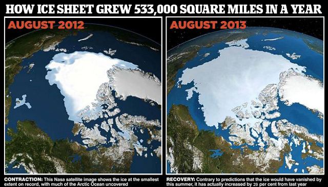
The heavy snowfalls during the months of December 2013 and January 2014 were caused by the excessive snow and ice deposits formed in the Arctic region during August 2013.
Last year, fifty states in the U.S. experienced heavy snowfalls during the months of December 2013 and January 2014. Based on the information released on the internet, I found out that the snowfall was the aftermath of the unusual formation of extensive ice deposits in the Arctic region. However, it is explained on the basis of the “Global Warming” conception.
We are told that the ice deposits on the surface of the sea in the North Polar Region melted and the resultant sea water on the surface evaporated with the heat and rose up. This affected the polar vortex, which usually circles the middle and upper troposphere and extends into stratosphere. This further altered the path of the polar vortex, which widely spread over the entire North American continent causing heavy snowfall. http://www.dailymail.co.uk
But the British Meteorological Department has found out from the records of 30,000 stations which recorded weather that during the past seventeen years, i.e. from 1997 to 2014, the world’s temperature had not risen at all. 
Hence the explanation given for the widespread snowfall in America last year, during the months of December 2013 and January 2014 on the basis of the “Global Warming” conception is totally wrong.
In the year 2007, BBC released a news item stating that a study conducted by Prof. Dr. Wieslaw Maslowski and researchers of NASA has predicted that particularly in the month of September 2013, the North Polar Region might be ice-free. http://news.bbc.co.uk/2/hi/science/nature/7139797.stm
But contrary to the predictions of those “Global Warming” scientists, the Arctic Region was not only not sea ice-free, but that ice had unusually formed in an area of around 5,33,000 square miles amounting to 29 percent of additional ice formation in the Arctic Region, and this was captured in the satellite images of NASA.
It proves that the unusual excessive formation of ice in the Arctic Region is the sole reason for the heavy snowfall in America.
There is also a possibility that this incident would recur if excessive ice is again formed in the Arctic Region. So, America, Canada and European nations may be alerted on these grounds.
...by Ganapathy Ponmudi is an independent scientist from Chennai, India.

========================================


Arunachal gets 1st spell of the pre-monsoon season, ending 8.30 am on 05.03.2015

An upper air trough from Bangladesh to coastal Odisha now runs from Western parts of Assam to North Bay of Bengal across Bangladesh and extends up to 0.9 km asl.

in mm (min 10 mm)

Anini - 99
Tuting - 93
Arzoo - 77
Etalin - 65
Tezu - 36
Passighat - 19
Khupa - 15
Geku - 12
Basar - 12

South AP continues to get much needed rains, ending 8.30 am 05.03.2015

The cyclonic circulation extending upto 0.9 km  a.s.l. over Comorin area and adjoining south Tamil Nadu now lies over Lakshadweep-Maldives areas.

in mm (min 15 mm)

Kuppam - 62
Santhipuram - 52
Botlagudur - 50
Vaddadi - 49
Rapur - 45
Gaadhirai - 39
Gudipalle - 38
Irala - 29
Kangundi - 29
Penumuru - 29
Lakkanapalle - 27
Cheedikada - 26
Chodavaram - 26
Kolamasanapalle - 23
Sydapuram - 22
Madugula - 20
Pakala - 19
Chandragiri - 16
Pathikonda - 15
Puthalapattu - 15
Torragudipadu - 15
Thota Kanuma - 15
Agarala - 15
Perumalpalle - 15
Dharmavaram - 15
Dubagunta - 15


Kanyakumari district gets heavy rains, ending 8.30 am on 04.03.2015

The cyclonic circulation extending upto 0.9 km a.s.l. over Comorin area and adjoining Srilanka now lies over Comorin area and adjoining south Tamil Nadu. Kulasekaram and Thirvattur have reported hail storms.

in mm (min 5 mm)

Chittar I - 64
Palacode - 44
Kulasekaharam - 41
Thoppampatti - 39
Thackalai - 39
Sankarankoil - 37
Pechiparai Agro - 35
Madhanur - 33
Anaikadangu - 32
Hogenekal - 30
Chittar II - 27
Kurunthancode - 26
Munchirai - 23
Kodaikanal Boat club - 21
Mettupalayam - 20
Omalur - 20
Kaveripakkam - 20
Wallajah - 20
Marandahalli - 20
Melalathur - 20
Kodaikanal - 19
Valparai - 18
Kannimar - 17
Pechiparai Dam - 16
Gudiyatham - 16
Macdonaldschoultry - 15
Nemili - 15
Dharmapuro - 14
Dindugul - 14
Timiri - 14
Eraniel - 13
Karumandurai - 13
Yercaud - 13
Periyar - 12
Marudhanadi - 12
Valparai Taluk office - 12
Dindigul - 12
Arani - 11
Udumalaipettai - 10
Neyoor - 9
Boothapandy - 9
Yelagiri - 9
Pochampalli - 9
Tondi - 8
Tiruttani - 8
Peranai - 8
Karamadai - 7
Paiyur - 7
Uthokottai - 7
Dharapuram - 6
Kodumudiyar - 6
Aralvoimozhi - 6
Pegumbahallah - 6
K.V.Kuppam - 5
Reddiyarchatiram - 5
Adyamadai - 5
Thunnakkadavu - 5
Virinijipuram - 5


1st spell of Pre-monsoon rains in Kerala, ending 8.30 am on 04.03.2015

The cyclonic circulation extending upto 0.9 km a.s.l. over Comorin area and adjoining Srilanka now lies over Comorin area and adjoining south Tamil Nadu.

in mm (min 5 mm)

Mavelikkara - 90
Thodupuzha - 76
Kozha - 46
Anchal - 31
Idamalayar - 28
Nedumangad - 18
Konni  - 17
Kanjirappally - 14
Poringal - 13
Punalur - 12
Peermade - 9
Lower Sholayar - 8
Neyyattinkara - 8
Pamba - 8
Kayamkulam - 6
Piravom - 6
Ponmudi - 6
Munnar - 6
Parambikulam - 5
Cherathla - 5
Thenmala - 5
Meenkara - 5

Dry regions of South AP gets good rains, ending 8.30 am on 04.03.2015

The cyclonic circulation extending upto 0.9 km a.s.l. over Comorin area and adjoining Srilanka now lies over Comorin area and adjoining south Tamil Nadu.

in mm (min 20 mm)

Kanduru - 63
Maavaturu - 58
Tallampadu - 56
Agarala - 54
Govindapuram - 49
Tirupati - 48
Gangudupalle - 45
Nimmanapalle - 44
Madakasira - 42
Chandragiri - 34
Penukonda - 34
Pedda Bodhanam    34
Dharmavaram - 33
Sri Bommaraju Puram - 31
Arogayavaram - 28
Peddamanthur - 28
Vempalle Juvupalli Road - 26
Cheedikada - 24
Chatlamitta - 23
Karani - 23
Koppunuru - 23
Lingala  - 23
Nandayal - 23
Puttaparthi - 20
Valasapalle - 20
Settigunta - 20
Yerrabalem - 20
Anantpur - 20

Sunday, March 01, 2015

Maharashtra Day temps on 3rd March below...

Uttrakhand continues to get heavy rains, ending 8.30 am 03.03.2015

Western Disturbance (W.D) M-1 as an upper air cyclonic circulation now lies over north Pakistan and adjoining Jammu & Kashmir and extends upto 4.5 km above mean sea level with a trough aloft roughly along Longitude 70.0°E and north of Latitude 20.0°N.

in mm (min 30 mm)

Nainital - 82
Champawat - 81
Dehradun - 71
Haridwar - 70
Mukteshwar - 62
Banbasa - 60
Haripur - 57
Jollygrant - 54
Deoprayag - 54
Pithoragarh - 51
Joshimath - 51
Naugaon - 48
Pantnagar - 47
Nandkeshri - 47
Koteshwar - 47
Rishikesh - 46
Ranichawari - 44
Tuini  - 44
Tehri - 41
Bharsar - 40
Marora - 39
Kalagarh - 38
Almora - 36
Roorkee - 36
Matela - 36
Srinagar - 33
Hathiari - 32

Day Temps in Maharashtra on Tuesday 3rd March 2015:

MADHYA MAHARASHTRA*

 POONA                    26.2(-7.9)     10.9(-2.9)

 LOHGAON               26.5(-8.5)     12.6(-3.4) 

 AHMEDNAGAR         27.5(-7.1)     10.1(-5.7) 

 JALGAON                27.4(-8.3)     14.2(-2.4) 

 KOLHAPUR             28.1(-6.5)     16.6(-1.7) 

 MAHABLESHWAR    21.5(-8.0)     08.8(-7.2) 

 MALEGAON            28.0(-6.8)     11.0(-3.7) 

 NASIK                    25.7(-7.9)     08.1(-5.8) 

 SANGLI                 28.8(-6.7)     15.3(-1.7) 

 SATARA                 27.6(-6.4)     12.0(-5.0) 

 SOLAPUR               30.1(-5.9)    16.0(-3.9) 

KONKAN AND GOA*

 BOMBAY                     27.9(-3.3)         19.6(-2.0) 

 SCZ                           28.0(-4.8)         15.0(-4.8) 

 ALIBAG                      26.3(-4.1)         16.9(-2.7)

 RATNAGIRI                 27.7(-4.0)         17.6(-3.2) 

 PANJIM                      30.8(-1.3)         19.3(-2.8) 

 MARATHWADA*

 OSMANABAD              29.0(-5         13.4(-5.7)

 AURANGABAD            26.4(-7.5)     14.2(-1.9)

 PARBANI                    29.4(-6.1)     17.4(-1.2)

 NANDED                    29.0(-6.7)     15.0(-2.4) 


Mumbai SCZ 2015 averages :

Jan - > 30.4 c / 16.3 c ( 0 mms )

Feb - > 32.2c / 17.8 c ( 0 mms )


Himachal Pradesh gets extended spell of heavy rains,  ending 8.30 am on 03.03.2015

in mm (min 30 mm)

Arki - 111
Naina Devi - 63
Jateon Barrage - 62
Kandaghat - 62
Dharmpur - 57
Paonta Sahib - 56
Kotkhai - 55
Sarahan - 54
Nahan - 52
Kheri - 52
Solan - 51 
Gohar - 49
Nauni - 47
Renuka - 46
Una - 45
Shimla CPRI - 45
Amb - 44
Jubbarhatti - 40
Bharwara - 39
Shimla - 38
Tinder - 38
Dharamshala - 36
Seobagh- 36
Bhandal - 36
Palampur - 30
Shahpur - 30
Yaswant Nagar - 30


2nd day of rains in Uttra Pradesh, ending 8.30 am 03.03.2015

Western Disturbance (W.D) as an upper air cyclonic circulation now lies over north Pakistan and adjoining Jammu & Kashmir and extends upto 4.5 km above mean sea level with a trough aloft roughly along Longitude 70.0°E and north of Latitude 20.0°N.

in mm (min 20 mm)

Baheri - 70
Puranpur - 67
Bareilly - 49
Muhammadi - 43
Nighasan - 43
Nighasan - 40
Hindon - 35
Hasanpur - 33
Chayal - 31
Allahabad - 30
Bara - 30
Narora - 28
Nareni - 26
Aligarh - 24
Muzaffarnagar - 24
Tundla - 21
Sambhal - 21
Agra - 20
Shahbad - 20
Lalganj - 20
Kanpur - 20
Moradabad - 20


A quick Observation:
As on 2 nd March (Monday ) Morning :

New Delhi:  Max 19.0c   Min 14.8c  and  Rain 56.8 mms
Pune:           Max 18.9c   Min 14.8c  and  Rain 10.5 mms


Maharashtra 's Phenomenal Day temperatures for 1st March...Shown as  Max (1st March), Dep from Normal, Min , Dep from normal and day's rainfall.

MADHYA MAHARASHTRA*

 POONA                            18.9(-14.4)                 14.1( 0.9)                   08.0  (44 mms overnight)
 LOHGAON                       19.6(-14.4)                 15.0( 0.0)                  12.0

 JALGAON                         25.8(-8.8)                  14.8(-0.5)                    13.0
 KOLHAPUR                      24.0(-10.0)                 16.6(-1.0)                   11.0
 MAHABLESHWAR         15.9(-13.0)                 12.2(-3.0)                   019.0  (36 mms overnight)
 MALEGAON                     21.0(-13.2)                 16.0( 2.2)                   nil nil
 NASIK                               20.5(-12.2)                 15.0( 1.9)                   00.2
 SANGLI                             22.8(-12.1)                 17.0( 0.9)                   06.0
 SATARA                           20.6(-12.3)                 15.0(-0.7)                   06.0
 SOLAPUR                        27.8(-7.6)                    15.9(-3.3)                   00.5

KONKAN AND GOA*
 BOMBAY                         26.5(-4.0)               19.4(-1.7)         nil nil
 SCZ                                 28.3(-3.8)              18.6(-0.5)           nil nil
 ALIBAG                            27.2(-2.7)               18.2(-0.9)          00.3
 RATNAGIRI                     28.5(-3.3)              18.0(-2.3)           32.0
 PANJIM                           30.6(-1.5)               21.5( 0.0)          12.0
 DHANU                           27.0(-2.3)               19.8( 0.7)           08.0

MARATHWADA*

OSMANABAD                  23.0(-10.8)               13.0(-5.0)               02.0
AURANGABAD               17.6(-15.6)               13.0(-2.0)              10.0
PARBANI                         22.3(-12.4)               16.2(-1.4)               06.0

BEED                              19.5(-14.5)                15.1(-1.2)

VIDARBHA*

AKOLA                      20.1(-13.8)         16.1(-1.3)                  08.0 
AMRAOTI                 18.0(-15.9)          15.0(-3.2)                 17.0
BULDHANA              16.7(-14.7)          13.8(-3.9)                13.0
BRAMHAPURI          28.1(-5.3)            19.3( 2.2)                 01.0
CHANDRAPUR         32.0(-2.8)            20.0( 2.0)                nil nil
NAGPUR                    22.0(-11.1)          17.9( 1.5)                06.0
Washim                      19.0                    15.4                         nil nil
WARDHA                   20.7(-12.8)           16.5(-0.8)               12.0
YEOTMAL                 17.0(-16.3)          14.0(-4.7)                18.0

Author's Note:
Day's high in New Delhi was lower than Vagaries' estimate of 21c...it was 19c on Sunday..17 mms rains was measured..Safdarjung total: 25.2 mm from this WD till 5:30 pm..and will continue as given in previous post.Vagaries' target ..45 mms till Monday evening
,
we had predicted a high of 21c, against which we saw 19c in Delhi on Sunday. And as far as rains are concerned, it almost matches with the map put up for Sunday,,Waqas just confirmed the heavy rains in Lahore and sialkot (as per the green colour shown)..." downpours in Gujrat,sialkot and Lahore ... Lahore reported 25 mm in 50 minutes...still continue"


2nd day of very heavy rains in Maharashtra, ending 8.30 am on 02.03.2015

Western Disturbance (W.D) as an upper air cyclonic circulation now lies over north Pakistan and extends upto 3.6 km above msl with a trough aloft roughly along Longitude 68.0°E and north of Latitude 15.0°N. Due to deepening of the westerly trough into central Arabian sea, wind confluence is continuing over central India and neighbourhood.

in mm (60 mm)

Ratnara - 130
Mundikota - 130
Paraswada - 117
Kardi - 110
Tiroda - 110
Rajoli - 110
Bhandara - 100
Ravanwadi - 98
Bela - 98
Thanegaon - 95
Gangazari - 94
Kargaon - 93
Kamtha - 92
Wadegaon - 90
Mahagaon - 90
Pachkhedi - 89
Mohadi - 86
Malewada - 85
Mandhal - 84
Varthi - 83
Akodi - 78
Weltur - 75
Tulasani - 74
Pahela - 74
Sakoli - 72
Davva - 72
Bhiwapur - 71
Mauda - 69
Dasgaon - 68
Nand - 68
Dhanla - 65
Nimkheda - 65
Mohadi - 65
Makardhokda - 64
Devrukh - 63
Khamari - 62
Kuhi - 62
Salwan - 62
Turkewadi - 62
Shivani - 62
Kodamendi - 61
Lamaj - 60
Kanhalgaon - 60
Khat - 60
Dhargaon - 60
Kondha - 60
Pavani - 60
Aamgaon - 60
Satephala - 60
Khapari - 60
Kandri - 60

Uttar Pradesh's Rainest day, ending 8.30 am on 02.03.2015

Western Disturbance (W.D) as an upper air cyclonic circulation now lies over north Pakistan and extends upto 3.6 km above msl with a trough aloft roughly along Longitude 68.0°E and north of Latitude 15.0°N. Due to deepening of the westerly trough into central Arabian sea, wind confluence is continuing over central India and neighbourhood.

in mm (20 mm)

Tilhar - 84
Khekra - 74
Shamli - 71
Chitrakoot - 53
Muzaffarnagar - 52
Kanpur - 49
Baraut -43
Banda - 41
Meerut - 38
Nareni - 37
Hardoi - 30
Charkari - 29
Lucknow - 27
Hapur - 24
Sikandra - 24
Hasanpur - 23
Lalganj - 22
Allahabad - 21
Nighasan - 20

Haryana's heaviest spell of rain this year, ending 8.30 am on 02.03.2015

Western Disturbance (W.D) as an upper air cyclonic circulation now lies over north Pakistan and extends upto 3.6 km above msl with a trough aloft roughly along Longitude 68.0°E and north of Latitude 15.0°N. Due to deepening of the westerly trough into central Arabian sea, wind confluence is continuing over central India and neighbourhood.

in mm (30 mm)

Jhahhar - 146
Naraingarh - 122
Karnal - 97
Narvana - 91
Uchani - 87
Ganaur - 82
Chacchrauli - 78
Narayangarh -75
Ambala - 73
Sonipat - 70
Chandigarh - 64
Kurukshetra - 63
Barara - 62
Panchkula - 61
Beri - 47
Kaul - 46
Faridabad - 45
Kaithal - 42
Hissar - 35
Balsamand - 35
Kalanur - 30
Hansi - 30
Palwal - 30
Sadalpur - 30

3rd day of Heavy rains in Kashmir, ending 8.30 am on 02.03.2015

Western Disturbance (W.D) as an upper air cyclonic circulation now lies over north Pakistan and extends upto 3.6 km above msl with a trough aloft roughly along Longitude 68.0°E and north of Latitude 15.0°N. Due to deepening of the westerly trough into central Arabian sea, wind confluence is continuing over central India and neighbourhood.

in mm (30 mm)

Katra - 129
Udhampur IAF - 100
Banihal - 79
Jammu - 72
Batote - 68
Chatha - 67
Govindapura - 66
Bhaderwah - 63
Qazigund - 59
Kukernag - 43
Kawa - 41
Pahalgam - 35
Srinagar - 35
Gulmarg - 34
Khudwani - 30
Kupwara - 30

Uttrakhand gets widespread rains, ending 8.30 am on 02.03.2015

Western Disturbance (W.D) as an upper air cyclonic circulation now lies over north Pakistan and extends upto 3.6 km above msl with a trough aloft roughly along Longitude 68.0°E and north of Latitude 15.0°N. Due to deepening of the westerly trough into central Arabian sea, wind confluence is continuing over central India and neighbourhood.

in mm (20 mm)

Dehradun - 72
Deoprayag - 72
Ranichwari - 71
Jollygrant - 63
Mussorie - 60
Nainital - 60
Kasya - 60
Koteshwar - 53
Mukteshwar - 50
Srinagar - 47
Pantnagar - 46
Champawat - 46
Marora - 45
Haridwar - 44
Uttarkashi - 42
Bharsar - 41
Roorke - 38
Tehri - 37
Rishikesh - 35
Kalagarh - 31
Nandkeshri - 30
Jakholi - 28
Pithoragarh - 24  
Joshimath - 23
Karnaprayag - 23
Rudraprayag - 20

Heaviest Rains in Himachal this year, ending 8.30 am on 02.03.2015

Western Disturbance (W.D) as an upper air cyclonic circulation now lies over north Pakistan and extends upto 3.6 km above msl with a trough aloft roughly along Longitude 68.0°E and north of Latitude 15.0°N. Due to deepening of the westerly trough into central Arabian sea, wind confluence is continuing over central India and neighbourhood.

in mm (40 mm)

Renuka - 149
Sirmaur - 122
Kandaghat - 122
Dharmpur - 120
Kasauli - 119
Nahan - 116
Sangraha - 115
Solan - 89
Amb - 85
Rajgarh - 84
Nauni - 83
Palampur - 81 
Una - 81
Kahu - 80
Mehre - 79
Chail - 78
Annu - 70
Bangana - 70
Gohar - 69
Bhandal - 68
Jubbarhatti - 68
Jhandutta - 67
Berthin - 66
Sarahan - 66
Paonta Sahib - 66
Kothipura - 65
Bilaspur - 60
Bharwara - 59
Dharamashala - 58
Hamripur - 57
Manali - 54
Rohru - 52
Chelsea - 51
Kasol - 47
Shimla CPRI - 45
Shimla - 44
Sundernagar - 43
Hipa - 42
Shahpur - 41
Kangra - 40

All India Highest 24hr rainfall of 2015 in Maharashtra, ending 8.30 am on 01.03.2015

The Western Disturbance as an upper air cyclonic circulation over Afghanistan & adjoining Pakistan extending upto 3.1 km above mean sea level persists with a trough aloft roughly along Latitude 15.0°N. Due to deepening of the westerly trough into central Arabian sea, a wind confluence is continuing over central India and neighbourhood.

in mm (min 40 mm)

Murtajapur - 169
Akot - 105
Telhara - 90
Barshitakli - 90
Mangaon - 70
Asegaon - 55
Yeotmal - 54
Mahuli - 54
Yedgaon - 53
Pune Pashan - 53
Pirangut - 53
Dawargaon - 53
Patur - 50
Ghuikhed - 50
Akola - 50
Tala - 50
Tiwasa - 49
Kude - 49
Shendurjan - 49
Rajgurunagar - 48
Wada - 48
Pune Chinchwad - 47
Warha - 47
Kadus - 47
Mozari - 47
Vayphad - 46
Chandur - 45
Pune City - 44
Pune Cagmo - 44
Talegaon - 44
Pune City - 44
Chincholi - 44
Pune AP - 43
Nandgaon - 43
Rajgurunagar - 43
Khed - 43
Parasapur - 43
Wadali - 42
Aambawade- 42
Pabal - 42
Pune Magarapatta - 41
Warkhed - 40
Mulshi - 40
Pawana - 40
Sangamner - 40
Gunjawani - 40
Chikhaldara - 40
Dhamangaon - 40
Golegoan - 40
Kurha - 40
Paud - 40
Kale - 40
Arvi - 40
Babulgaon - 40
Alandi - 40
Badanera - 40
Shivani - 40
Palaskhed - 40
Talegaon - 40
Bhatkuli - 40
Dattapur - 40
Giroli - 40
Pune Lavale - 40
Loni - 40
Pune NDA - 40
Otur - 40
Papal - 40
Benoda - 40
Dhamangaon - 40
Dhamangaon - 40
Male - 40
Ghodegaon - 40
Sawalikheda - 40
Mahuli - 40
Shirkhed - 40


2nd day of rains in Tamil Nadu as Dindugul gets battered, ending 8.30 am on 01.03.2015

The cyclonic circulation over Comorin area and adjoining Sri Lanka has also become less marked.

in mm (min 5 mm)

Manjalparapu - 91
Thadiyankudisai - 72
Marudhanadi Dam - 50
Idappadi - 36
Kulesekharam - 31
Pongalur - 32
Avinasi - 31
Thandikudi - 27
Kangayam - 25
Pegumbahallah - 24
Vellakoil - 23
Konganapuram - 21
Pechiparai - 20
Sivagiri - 18
Periyanayakkanpalayam - 17
Morappur - 17
Kundha Bridge - 16
Nambiyur - 15
Karur - 14
Srivilliputhur - 12
Kadamaparai - 13
Sarcarsamakulam - 11
Tiruppur - 10
Pappireddipatti - 10
Sankarankoil - 10
Kovilpatti - 10
Chennimalai - 9
Harur - 9
Manamadurai - 8
Sattur - 8
Pykara - 8
Macdonaldschoultry - 6
Glenmorgan - 6
Perundurai - 5
Gobi - 5
Uttukkuli - 5
Manur - 5
Periyar - 5
Pillur - 5
Annur - 5
Manalar - 5
Upper Kodayar - 5


Vagaries Rainman

  6th September  The Low is stuck because of 700 resistance winds. .