Monday 31st January...Dry, Cold Weather Prevails in North!


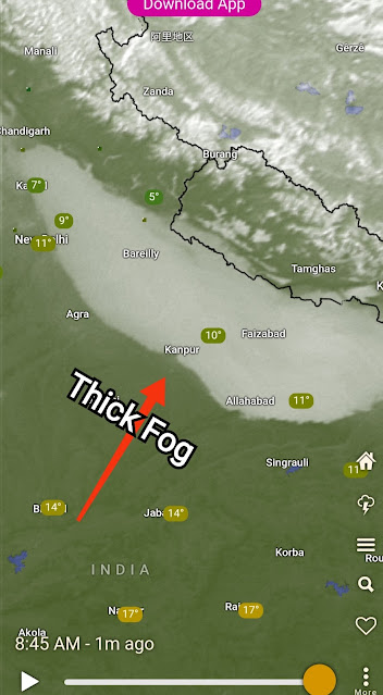
Fog in U. P. On Monday Morning
Mumbai/Pune Weather forecast for next 3 days (31st Jan, 1st and 2nd Feb)...published 10:45 pm on Sunday 30th Jan
Mumbai and Pune minimum temperature has remained slightly lower than forecasted, more dryness leading to drop in night temperature and large variation between day and night temperatures.
Sunday,Relative humidity was just 43% in Santacruz, Mumbai and 28% in Pune.
Next 3 days will see maximum temperature of around 31-32°C in Mumbai while minimum may remain around 17°C. Interior konkan and Thane district can see min around 13°C.
Pune to witness a rise in max temperature to about 32°C due to westerlies and minimum can remain around 11-13°C.
A fresh Western Disturbance F-1 will start affecting the country from 2nd/3rd February which may bring another round of cold weather.
More updates soon.


1 comment:
Credit Australian Government Bureau of metereology latest issued 01 02 2022
Issued 1 February 2022
The latest Climate Driver Update and Climate Model Summary are now available on the Bureau's website.
La Niña likely to persist until early autumn
A mature La Niña event remains active in the tropical Pacific. Climate models suggest the 2021–22 La Niña is near or at its peak, with a return to neutral El Niño–Southern Oscillation (ENSO) likely early in the southern hemisphere autumn. Autumn is the usual time of the year in which ENSO events decay and return to neutral. La Niña increases the chance of above average rainfall across much of northern and eastern Australia during summer. Significant weather can still occur as La Niña weakens, especially as the peak of the Australian tropical cyclone season is around February/March.
Oceanic indicators of ENSO continue to show a clear La Niña signal, with cooler than average sea surface temperatures in the eastern tropical Pacific, and cooler sub-surface waters supporting the cooler waters at the surface. However, these cooler sub-surface waters continue to ease. Most atmospheric indicators also show clear La Niña patterns, with decreased cloudiness along the Date Line and trade winds either close to average or slightly increased. While the 30-day Southern Oscillation Index (SOI) has experienced some short-term fluctuation, the 90-day SOI is still firmly in La Niña territory.
The Madden–Julian Oscillation (MJO) is currently weak, but models indicate it may strengthen in the eastern Indian Ocean or western Maritime Continent in the coming week. Typically, when the MJO is in the eastern Indian Ocean it may provide a boost to La Niña by encouraging strengthened trade winds in the Pacific Ocean. As the MJO approaches the Maritime Continent, an increase in cloudiness and rainfall over northern Australia is more likely.
The Southern Annular Mode (SAM) index has recently risen to positive levels. It is forecast to remain positive, but gradually weaken, over the next three weeks. A positive SAM during summer typically brings wetter weather to eastern parts of Australia, but drier than average conditions for western Tasmania.
The Indian Ocean Dipole (IOD) typically has little influence on global climate from December to April.
Climate change continues to influence Australian and global climate. Australia's climate has warmed by around 1.44 °C for the 1910–2019 period. Rainfall across northern Australia during its wet season (October–April) has increased since the late 1990s. In recent decades there has been a trend towards a greater proportion of rainfall from high intensity short duration rainfall events, especially across northern Australia.
More information
Media enquiries: (03) 9669 4057 media@bom.gov.au
Next update expected on 15 February 2022
Post a Comment