Monsoon Watch -3 2013 (Additional)...April 30th.
The arrival date is calculated seeing todays position. Further from today, we presume the normal rate of progress of the Monsoon (In cricket parlance:projected score at the current run rate).
This initial estimated dates are subject to some changes, and will be finalised around mid-May, when the puzzle pieces look well arranged.
As of today, there seems to be a slight delay in both, Arabian Sea and Bay Branches of the Monsoon. There continues to be a doubt on the timely arrival of the Monsoon in the Bay branch.
Bay branch needs to wait a few days for the embedded Lows to fizzle out, and to get going.

Arabian Sea Branch: Though there is some improvement in most of the parameters, there is still much to be achieved, and most parameters are still lagging behind time, and are -ve.
The Arabian Sea branch, may not be affected by the temporary "dis-organisation " in the equatorial winds at the equator. ( Provided they regroup fast).
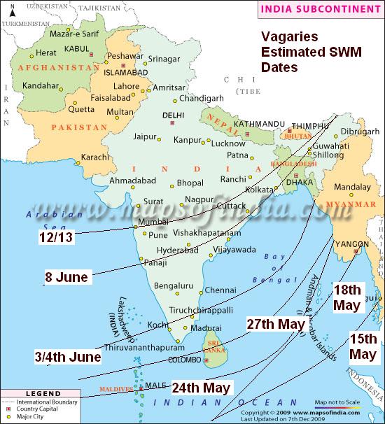
(Dates in brackets are the normal dates of arrival).
On these calculations, Vagaries would maintain the Monsoon to reach Maldives around the 24th of May 2013(20th May), Sri Lanka around 27th/28th of May (25th May).
Kerala by the 3/4th June (1st June).
Hence, maintaining and presuming the normal rate of progress, Goa should get Monsoon rains by around 8th June (5th June).
Mumbai by 12/13th June (9th June). Regular Pre Monsoon thundershowers could start from around 6/7th June 2013.
Bay Branch: SWM should hit South Andaman Sea around 15th.May (12th May), and rest Andaman Islands by 18th-20th May 2013.
Generally moves up (normally) the Bay at a sustained speed, and Kolkata should see Monsoon arrival by the 9th of June, along with the NE states.
We stop at this initial progress, and work out further region wise progress at a later date (as is the usual practice in Vagaries' MWs).
These Dates are worked out and estimated as per my personal calculations and may not be used for commercial purposes.The dates are not binding on anyone and no responsibility is taken if used for any purposes.
The arrival date is calculated seeing todays position. Further from today, we presume the normal rate of progress of the Monsoon (In cricket parlance:projected score at the current run rate).
This initial estimated dates are subject to some changes, and will be finalised around mid-May, when the puzzle pieces look well arranged.
As of today, there seems to be a slight delay in both, Arabian Sea and Bay Branches of the Monsoon. There continues to be a doubt on the timely arrival of the Monsoon in the Bay branch.
Bay branch needs to wait a few days for the embedded Lows to fizzle out, and to get going.
Arabian Sea Branch: Though there is some improvement in most of the parameters, there is still much to be achieved, and most parameters are still lagging behind time, and are -ve.
The Arabian Sea branch, may not be affected by the temporary "dis-organisation " in the equatorial winds at the equator. ( Provided they regroup fast).
(Dates in brackets are the normal dates of arrival).
On these calculations, Vagaries would maintain the Monsoon to reach Maldives around the 24th of May 2013(20th May), Sri Lanka around 27th/28th of May (25th May).
Kerala by the 3/4th June (1st June).
Hence, maintaining and presuming the normal rate of progress, Goa should get Monsoon rains by around 8th June (5th June).
Mumbai by 12/13th June (9th June). Regular Pre Monsoon thundershowers could start from around 6/7th June 2013.
Bay Branch: SWM should hit South Andaman Sea around 15th.May (12th May), and rest Andaman Islands by 18th-20th May 2013.
Generally moves up (normally) the Bay at a sustained speed, and Kolkata should see Monsoon arrival by the 9th of June, along with the NE states.
We stop at this initial progress, and work out further region wise progress at a later date (as is the usual practice in Vagaries' MWs).
These Dates are worked out and estimated as per my personal calculations and may not be used for commercial purposes.The dates are not binding on anyone and no responsibility is taken if used for any purposes.


15 comments:
Hail the Master !! A T-20 Suspense indeed !!
hello rajesh sir is there any chance for the el nino to get stronger in the near future
nice explaination sir...
Overall it looks like a 3 to 4 days delay as of now.
Emkay how is the heat in panvel? Thane seems to be always 2/4°c hotter than scruz . Awaiting the pleasant late may early June climate...
@GSB. Badlapur between 39-40c from past 6 days. Hot winds start from 11am onwards from N/NW. Missing SW winds with low clouds in morning /night time which were daily appearing till 22 Apr..
yesterday, in the evening south Goa received thundershowers.
Parts of Goa including Panjim, Porvorim received showers from 7.30 pm to 9.30 pm. Coastal South Goa was completely dry.
Naveen: El-Nino is not present at all, so no question of getting stronger. Its neutral now, and expected to be till July at least.
Storm in Mahableshwar on May Day records 24 mms. Panchgani strong winds claim 2 lives (as per shiraz)
Again bad news for South India (south,SE India - KAR,TN,KER). Some of the models predict below normal 2013 monsoon. KAR is facing 3 years of sucessive drought, BANG city lowest rain in 2012, TN complete 2012 NE monsoon failure.
http://newindianexpress.com/cities/bangalore/Monsoon-may-play-hide-and-seek-again/2013/04/27/article1563887.ece
http://newindianexpress.com/cities/bangalore/Monsoon-may-play-hide-and-seek-again/2013/04/27/article1563887.ece
Any reason for this shifting dry areas snd massive climate change.
GSB sorry didnt see ur mesg b4.
Panvel was relatively stable in heat over past 3 days but increased humidity and also some pleasant winds post 9 PM last 2 days
Hello sir
Even though SWM not yet started than Why are we seeing a big cloud cover in northeast india.
Are they just pre monsoon showers.
Hello sir
Even though SWM not yet started than Why are we seeing a big cloud cover in northeast india.
Are they just pre monsoon showers.
As per rajesh sir's prediction, a thick cloud cover is seen forming in the bay , we might soon see a low forming in the bay .
Rajesh Sir
GFS models are predicting a cyclonic circulation in the bay which might cause widespread rains up to central India.If this happens what will be the prospects of monsoon progress.
Vinod: The NE rains are not unusual, as we should have the trough there in place at this time...it is normal and positive.
Sam: yes, the MJO wave has to be monitored now, and its Bay impact..good observation.
Saeed Ahmed: What impact the visualised Low (if it forms) will depend on its track, strength and where it forms..
we will monitor it in vagaries. I am putting up a note late tonite..(Thursday)
Post a Comment