Change of weather for parts of Maharashtra and Madhya Pradesh this week...chances of thunderstorms!
We waited before issuing the forecast...as it is expected around 5th March onwards.
Forecast from 5th - 9th March:
Combination of:
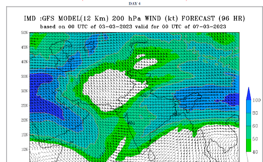
- A strong dip in westerly jet stream (mid-upper level westerly trough 500 - 200 hPa),
- Low level trough (850 hPa) in easterlies
- Moisture from Arabian Sea and Bay of Bengal
may lead to thunderstorms forming in central and western parts of the country.
Parts of north Maharashtra - Dhule, Nandurbar, Jalgaon, Nashik, Ch. Sambhaji Nagar, Ahmednagar, Akola may get rain/thunderstorms in patches. Some places may get hail.
Parts of Pune district can also see some cloud build-up and light rain/thunderstorms during 6th-9th March. Rain belt may shift east to cover Jalna, Akola, Washim, and Amravati districts after 6th March.
Mumbai and konkan - No major change in weather, but some increase in humidity is expected.
Madhya Pradesh: Western parts of the state close to Gujarat, and cities like Indore, Bhopal, Khandwa can get thunderstorms with chance of hail from 5th March onwards. Rain belt may spread to cover eastern and northern parts of the state on 6th-7th March.
Rajasthan: Light showers/thundershowers in western parts of the state tomorrow on 4th March. Eastern and southeastern parts of the state such as Jaipur, Udaipur, Kota can get thundershowers during 5th - 7th March.
More details by weekend/early next week...


No comments:
Post a Comment