12th July...
Kutch covering annual rains soon...desert bonanza
Mumbai Live Storage spurts to 50%..6 Months Stock !
----------------------------------------------------------------------
Ukai Dam Gujarat Storage at 44% ........👉
Posted 11th afternoon...BB-6 could induce a mid level vortex/MTC near North Maharashtra/south Gujarat region, which could result in the heavy rain event
Rains could increase further along North Konkan, northern western Ghats and south Gujarat from tonight for 2-3 days.
Mumbai: From 11th Monday Night, frequent showers of Heavy rain expected for Mumbai region. Strong winds on Wednesday. Exceeding100 mms/ Day
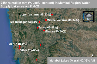
Mumbai Lakes at 40% Storage ......👉Pune: Next from Monday night, for 2 days, Parts of Pune could also see moderate to heavy...Exceeding 25-30 mms/day.
Possibility of very heavy rains over parts of Thane, Palghar, Nashik districts on 11 and 12 July. Jalgaon ( Tuesday heavy..about 60-70 mms) , Dhule and Nandurbar districts of Maharashtra may see moderate to heavy rain.
Weather likely to be very windy over northern western Ghats, mainly from Mahabaleshwar to Trimbakeshwar stretch. Visibility could be low due to clouds and heavy to very heavy rains. Avoid travel in these areas.
Places in Gujarat from Navsari to Surat as well as Vadodara region could see heavy rain during this period.
Bharuch...Heavy rains next 2 days...Exceeding 60 mms/day
Surat: Heavy showers next 2 days...Exceeding 60-75 mms/day.
Valsad: Heavy rains Monday/Tuesday..exceeding 90-100 mms/day.
Bodeli, the district has seen over 530 mms in last 24hrs..will see a decrease in rain intensity.


7 comments:
As of now is Gujarat wettest place beating konkan in terms of highest 24hrs rain intensity ?
With bodeli gujarat recording 540mm in 24hrs.
Will monsoon revive over kerala, South AP ?
What is the meaning of mid level Vortex/MTC?
What will be the situation in Ahmedabad?
sir maharastra ghat ke rainfall data daily upload kro please
Hiren...Our team puts ghats rainfall when the Amounts are high. They make another of effort to compile.
Pratik...Atmospheric Circulation In Midlatitudes
As of now on west coast Kerala is driest with no proper rains since June. No system over lower latitudes. South AP, interiors of KAR no rains.
As usual SWM will be dominated by GUJ MAHA
Kutch is no longer desert. Gujarat is becoming wetter every passing year. Has advantage of both bay and as systems.
Driest places are south AP rayalseema, parts of TN and interiors of KAR which are dependent on NEM.
Welcome back SSET.
Refer to India rainfall map.
https://mausam.imd.gov.in/imd_latest/contents/index_rainfall_state_new.php?msg=C
All the regions you mentioned are doing pretty well.
Kerala got huge surplus in May and the seasonal rainfall for Kerala is way over normal.
Our met department uses a arbitrary cut off date of 1st June. If we could get the map from 1st May to today, Kerala would be showing a good surplus. Even since 1st June Kerala has received 70 cm rain which is very good.
On the other hand as of now UP is-60% since 1st June with almost no rain in April and May. It has got only 8 cm rain since 1st June.
Good to go by facts. I have never understood why you make up stories that don't stand up to any scrutiny.
Post a Comment