The Arabian Sea system is now a depression.
It was stationed at 15.5N and 63.5E at 5.30pm IST today, 31st, that is 1050 Kms South-West of Mumbai.Core pressure is now 1001 Hpa, and the wind speed is 25 Knots.
System is expected to intensify,as the SST is conducive at 31c.
As expected,it has moved North-West,and is likely to continue in that direction for the next 24Hrs.Subsequently,it should encounter the W.D, and as mentioned yesterday in my write up, recurve towards the India/Pakistan border by the 3rd. of June.
Effectively, I maintain that the rainfall will decrease in Kerala and Karnataka coast from 1st. June.
But, Goa and Maharashtra coasts will get light to moderate rains from Wednessday till around the 6th. whilst the interior regions of Maharashtra, Karnataka and entire T.N will remain practically dry till the 8th./9th. of June at least.
Readings of 31st. May 2010:
Higheat in Asia: Dadu (Pakistan): 48c
Highest in India: Ganganagar: 46.4c
Hottest Night: Bikaner: 31.1c
Mumbai today: Colaba: 36.4c, Santa Cruz:35.2c.
Mumbai will get its pre-Monsoon showers from Wednessday.
Forecast till Saturday is that days will be sweaty and hot, as there will be cloudy skies and some rain.
Monday, May 31, 2010
During last week,the observed progress of the Monsoon has been tardy and slow. We were expecting a slow movement Northwards after moving upto Karnataka, but, the progress slowed down just after the monsoon had reached the Southern tip of Kerala.
Now, the reasons could be attributed to the succesive movements of the W.Ds in the north, and the resultant slow de-forming of the ridge in the Arabian Sea last week.
The latest development, 94A, a low pressure area,now shows the churning of the Western branch of the monsoon. The Arabian Sea has livened up.
But what can the rain hungry Western Indian region expect now?
There are 2 different estimates for the system.
1.Some models, predict 94A, now at the low pressure stage, to strengthen and become a depression. The forecasted movement is in the North-Northwest direction. By the 4th./5th, it is predicted to move towards the Oman coast, and then fizzle out.
Resultantly, only moderate rain, could be expected along the West coast of India from the 2nd. upto the 6th. of June. But, as the system moves away from the Indian coast, rainfall would diminish in Kerala. If this option prevalis,a lot of moisture and clouds could be sucked into the depression from the Arabian Sea effecting the rains along Western India.
2. Other models, including ECMWF forecasts 94A to develop into a depression, and move North. It is estimated to hit the Gujarat coast by the 5th.
The rain result would be good rains along the west coast of India, and into Gujarat's Saurashtra region from the 3rd.
With these 2 options open, we will monitor the system and check its behaviour.
Personnaly,I would go in for a mixture of the 2 options.A re-curving option after moving towards Oman. With a W.D. approaching around the 3rd, the system would re-curve towards the Northeast around the time the W.D. moves along Pakistan. The land striking region in this case would be near the India/Pakistan Border region.
In this case, the Monsoon would initially cover Kerala, and maybe South coastal Karnataka, and then weaken to some extent till the "to be" depression fizzles out.
Highest in Asia on 30th. May: 48c Nawabshah (Pakistan).
Highest in India: Chandrapur: 46.6c.
Mumbai today: Colaba 35.8c, Santa Cruz: 34.8c.
Due to the depression forming in the Arabian Sea, Mumbai can expect Pre-Monsoon showers on the 2nd. Some pre-monsoon rainfall can be expected in Mumbai thereafter till the 6th. But weatherwise, it will get stuffy and humid once the pre-monsson rains commence.
Sunday, May 30, 2010
Spectacular 26 MAY 2010 ..one of the most important days in the history of Meteorology.
On 26th. May 2010, we have pushed Mother Nature to its Limit !!Record breaking heat in Pakistan
Highest maximum temperature was recorded 53.5°C in Mohen ju Daro and 53c in Sibbi.
Lake Hvasu City 128F (53.3C) of June 1994 is OUSTED FROM THE SECOND PLACE.
1-NEW ASIAN RECORD
2- NEW WORLD RECORD FOR MAY
Also , the Pakistan Heat Wave shows the other extremes as: 52.5c in Jacobabad, Larkana and Padidan.52c in Nawabshah, and 50c in Rahim yar Khan, Dadu and Sukkar.
In India, we had Ganganagar at 49.3c and the Cool Clime Simla in the Himalayan State of Himachal at its highest ever of 32.4c.
Sorry for the late report. Publishing the latest on the Arabian Sea system and Monsoon update by tonite, 30th.
Tuesday, May 25, 2010
Monday, May 24, 2010
Its getting Unbearable Now !
Gujarat continued to reel under the continuing heat wave as its impact was felt by the common man.
The heat wave claimed five lives in Gujarat while the northern belt continued to reel under intense hot conditions today with the mercury settling above the 46/47-degree mark at several places.
Hundreds fell ill in Ahmedabad due to intense heat.The locals are having a tough time with temperatures soaring over 45c in city.
Heat Wave is continue in entire Rajasthan.Tempreture is above 45/46c at most of the places in the states. "Yesterday, mercury crossed 49c at Phalodi in Jodhpur District." Unconfirmed report.
Delhiites had to bear with scorching heat as the maximum hovers around at 44c, 4 notches above normal, while the minimum is around 30/31c degrees.
A diagram showing the Above Normalcy of the last 1 month in some of the "Hot spots" in India.


The South -West winds in the Arabian Sea seem to have tapered a bit. From my last report, when they were speeding at an ideal 30 knts, they seem to be below that now.The wind chart shows the maximum gusts in the Bay, and near the Somali coast. A little delay, again, for Kerala? After having advanced into Sri Lanka, and the extreme tip of India,( My assumption), it now seems the slight "pause" is taking effect.
As on now, I see the Monsoon advancing into Karnataka coast by 1st June, and Goa south Konkan around 5th.June.

The seasonal low over the desert regions is now at a core of 996 hpa. And is widening its base, what with the 49-51c range in Sindh and Rajasthan.

Today's (Monday,24th.) Readings:
Hottest in Asia: 51c in Nawabshah, Larkana and Jacobabad.
Hottest in India: 48.2c in Kota, and 48.1c at Ganganagar.
And now,the real hot stuff ! Hottest Night: 34.4c(+8c) in Jaipur and 33.5c in Ajmer.
Today's day in Mumbai was at 36.0c Colaba, and at 34.8c S'cruz. .Night was a gruelling 29.3c. This week will be partly cloudy and sweaty. Nights are getting to the 30c forecasted yesterday :)
No rain expected till Sunday, at least.
Next week's forecast after my return from the Kumaon Himalayas, where I will be camping till Sunday. Next blog posting earliest on sunday, 30th. May.
News from our Partner Blog:
Increasing heat in U.K. In detail account of it on Mark's blog."High pressure dynamics which is allowing a possible 30C high for London and south tomorrow"
kapadias@gmail.com
Gujarat continued to reel under the continuing heat wave as its impact was felt by the common man.
The heat wave claimed five lives in Gujarat while the northern belt continued to reel under intense hot conditions today with the mercury settling above the 46/47-degree mark at several places.
Hundreds fell ill in Ahmedabad due to intense heat.The locals are having a tough time with temperatures soaring over 45c in city.
Heat Wave is continue in entire Rajasthan.Tempreture is above 45/46c at most of the places in the states. "Yesterday, mercury crossed 49c at Phalodi in Jodhpur District." Unconfirmed report.
Delhiites had to bear with scorching heat as the maximum hovers around at 44c, 4 notches above normal, while the minimum is around 30/31c degrees.
A diagram showing the Above Normalcy of the last 1 month in some of the "Hot spots" in India.


The South -West winds in the Arabian Sea seem to have tapered a bit. From my last report, when they were speeding at an ideal 30 knts, they seem to be below that now.The wind chart shows the maximum gusts in the Bay, and near the Somali coast. A little delay, again, for Kerala? After having advanced into Sri Lanka, and the extreme tip of India,( My assumption), it now seems the slight "pause" is taking effect.
As on now, I see the Monsoon advancing into Karnataka coast by 1st June, and Goa south Konkan around 5th.June.

The seasonal low over the desert regions is now at a core of 996 hpa. And is widening its base, what with the 49-51c range in Sindh and Rajasthan.

Today's (Monday,24th.) Readings:
Hottest in Asia: 51c in Nawabshah, Larkana and Jacobabad.
Hottest in India: 48.2c in Kota, and 48.1c at Ganganagar.
And now,the real hot stuff ! Hottest Night: 34.4c(+8c) in Jaipur and 33.5c in Ajmer.
Today's day in Mumbai was at 36.0c Colaba, and at 34.8c S'cruz. .Night was a gruelling 29.3c. This week will be partly cloudy and sweaty. Nights are getting to the 30c forecasted yesterday :)
No rain expected till Sunday, at least.
Some rainfall figures during precipitated by "Laila". Information given by Pradeep
Cyclone Laila rainfall toppers
Addanki received the highest rainfall of 522 mm
Maddipadu 510 mm,
Kothapatnam 258 mm
Ongole 142 mm
Next week's forecast after my return from the Kumaon Himalayas, where I will be camping till Sunday. Next blog posting earliest on sunday, 30th. May.
News from our Partner Blog:
Increasing heat in U.K. In detail account of it on Mark's blog."High pressure dynamics which is allowing a possible 30C high for London and south tomorrow"
kapadias@gmail.com
Sunday, May 23, 2010
Readings as on 23rd. May:
Hottest in Asia: Sibi and Nawabshah (Both Pakistan): 50c
Hottest in India: Churu (Rajasthan): 47.7
Hottest Nights:Bikaner:32.9c,Chandigarh:32c, Sibi and Larkana(Pakistan):32c
Mumbai day temperatures Colaba:36.0c, Mumbai S'Cruz:34.5c.And 29.2c the minimum.
Mahableshwar:31.2c
Next few days, Mumbai will have partly cloudy skies, hot and humid, with nights possibly going upto 30c.
Saturday, May 22, 2010
Readings as on 22nd. May: IT's 51c !!
Highest in Asia:Larkana (Pakistan): 51c, Sibi (Pakistan) 50c, Jacobabad: 50c.Incidently,the evening humidity in Larkana was 5%.
Highest in India: Ganganagar: 48.9c,Hissar: 48.0c,Jaisalmer:47.7c, Kota:46.7c.
Hottest Night:Jodhpur:31.0c, Ahamdabad:30.6c.

That's Hot ! Its the desert state of Rajasthan and adjoining Pakistan that is bearing the brunt of very gruelling heat! Highs of 51c in Pakistan and 48.9c in India now,is hopefully going to shape up the "tardy" development of the seasonal low in Rajasthan/Sindh. A core pressure of 998 hpa is now prevailing, but its been the same since "Laila's" formation. Forecasts show it the pressure coming in the region down to 996 hpa, by the 25th.of May.
Our blog poll is getting interesting now. With the Monsoon staging a "come and go" attitude, the % of the different dates go on varying. Now, the first 3 options are suddenly running neck-to-neck !! Surprising turn !
News from Our Partner Blog:
And now, U.K. has started getting "warm".I put it in comas,as readers in the sub-continent may not agree to calling this "warm" !
"Britain warms to Meditereanean levels as High sits overhead".
-By Mark Vogan
Monsoon Watch - 9:
By Friday late night, the depression (erstwhile "Laila") over coastal Andhra Pradesh moved north-northeastwards and weakened into a well-marked low pressure area over coastal Andhra Pradesh and Telengana. The rainfall area has now moved into the coastal Orissa region, but much less in intensity.We can see the winds in the 30-40 knts range around the 2 systems.(IMD Wind Map).
With the development of a low level convection over Comorin Area, we can expect the Monsoon to further move Northwards,covering the Comorin area, and the whole of Sri Lanka.With the Westerlies now at 30 knots,we can expect this within the next 2 days. Hence, the Monsoon's Arabian Sea branch will be at the doorstep of peninsula India.

Further 2 days ahead, after the advance into Sri Lanka by today/tomorrow, I think we can get a surety of its advance into Kerala around the 24th./25th. of May.
The only hesitation on my thinking on this is the ITCZ. The wind map shows the ITCZ along the equator stretching from Africa upto the Bay of Bengal.This parameter, the line, should move into the 5N region around the South Arabian Sea to carry the embedded Monsoon current along with it. Normally, I do not have doubts that this will hold up the advance, as In the Bay, the ITCZ is at 5N.

As on today, I pesonally still feel the Monsoon's advance will halt for 4/5 days after reaching upto coastal Karnataka. This may happen, as discussed before, because the thrust we see now is a result of a "rebpond reaction", and may fizzle out temporarily.
21st. May was a real HOT day in the desert state of Rajasthan and Gujarat. Notice the abrupt cooling towards the eastern areas. IMD map indicates the extreme heat over the regions.Even in adjoining Pakistan we see a blistering heat wave.

Hottest in Asia: Daddu (Pakistan): 50c
Hottest in India: Idar (Gujarat): 48.5c. The highest ever in Idar. The TOI says its the highest temperature ever recorded in Gujarat State. I have yet to confirm that.
Some HotSpots in these 2 States:
Gujarat; Ahmadabad: 46.8c, Bhuj:46.0c,Baroda:45.2c,Rajkot:45.5c.
Rajasthan:Jaisalmer:47.2c,Ganganagar:46.3c,Bikaner:45.6c,Kota:45.2c
Mahableshwar: Day 29.6c, Night 19.5c
Mumbai: Colaba:35.0c, S'Cruz: 34.4c.
Mumbai will have partly cloudy skies this weekend, and days and nights will be hot and humid. Westerly breeze may bring some respite, but more humidity alongwith it. Pre Monsoon rains expected in Mumbai around 1st. week of June.
Thursday, May 20, 2010
Readings as on 20th. May:
Hottest in Asia : Nawabshah (Pakistan):48c
Hottest in India: Akola: 47.1c
Hottest Nights:Jodhpur:32.0c,Satna: 31.8c, Jaisalmer: 31.2c
Mumbai:Colaba:34.8c,S'Cruz:34.0c.Thane(AWS) 36.7c
great britain, europe
UK Heat ready to push highs between 22-28C from London to Inverness
-Mark Vogan
Hottest in Asia : Nawabshah (Pakistan):48c
Hottest in India: Akola: 47.1c
Hottest Nights:Jodhpur:32.0c,Satna: 31.8c, Jaisalmer: 31.2c
Mumbai:Colaba:34.8c,S'Cruz:34.0c.Thane(AWS) 36.7c
News form our Parner Blog:
And now, after a cold spell, the typical "English Weather' is showing its vagaries ! A heat wave now!(Nothing like the Sub-Continet heat though).great britain, europe
UK Heat ready to push highs between 22-28C from London to Inverness
-Mark Vogan
Update on "Laila".
Today,Thursday,cyclone 'Laila' has crossed the coast at Bapatla (A.P.) and weakened.Maximum SURFACE wind speed is estimated to be about 45 KNOTS around the system centre. The core pressure is about 992hpa.
Gale force wind with speed reaching 100-110 kmph gusting to 120 kmph likely along and off Andhra Pradesh coast during next 12 hours.Storm surge of 1.5 to 2 metres above the astronomical tide is likely.
Very heavy rainfall was recorded in Coastal A.P./North Coastal T.N. Some of the heaviest figures of rain (Cms) in the last 24 hrs:
Ongole and Achampet (Guntur dt ) recorded extremely heavy rainfall of 32 and 27 Centimetres respectively.
Narasapur 18, Ponneri (Tiruvallur dt) 17,Tada (Nellore dt) and Tanaku (West Godavari dt) 15 each, Sullurpet (Nellore dt) 14, Amalapuram (East Godavri dt) and Cholavaram (Tiruvallur dt) 13, Machilipatnam and Bhimavaram (West Godavari dt) 12 each, Chennai, Anna University (Chennai dt), Tamaraipakkam (Tiruvallur dt), Kaikalur and Avanigadda (both Krishna dt) and Kakinada 11 each. Several stations had between 5-10cms.
A senior scientist involved in tracking the cyclone said that the strong upper winds at an altitude of around 10 km were steering 'Laila' in a Northerly direction.
Now on, it will graze the coast (I think I've used this word too often last 2 days, anyway...) and then there are signs of it re-emerging in northern Bay of Bengal over the weekend as a weak system (mentioned in previous blog).
There have been precedents of cyclones re-emerging after landfall and the movement of 'Laila' was not an unusual one.
Aila to Laila: Will the cyclone have any effect on the monsoon? FAQ on the blog.
Last year’s monsoon was severely weakened by both the El Nino effect as well as by cyclone Aila, which hit the Bay of Bengal just as the Monsoon was setting in.
This year brings its own difficult portents.
El Nino — is not as strong as it was in 2009. As for Cyclone Laila in the Bay of Bengal, we can only hope that it will dissipate before it can do any real damage.
We hope for no "damage" as North India is suffering its hottest summer in a century and predictions of a normal monsoon had been most heartily welcomed.
Arabian Sea branch, as mentioned, I see the re-grouping of the south-west winds to monsoon speed and strenght in a couple of days. Then,a pause still seems to be a possibility.
"Laila" yet to strike:
01B (LAILA), LOCATED APPROXIMATELY 150 KMS NORTH-EAST OF NELLORE, HAS TRACKED NORTH-NORTHWESTWARD
AT 06 KNOTS OVER THE PAST SIX HOURS.WIND SPEED AT 55 KNOTS AND PRESSURE 986 HPA.
 EXPECTED MAKE LANDFALL TODAY NEAR MACHILLIPATNUM.WINDS AT LANFALL COULD BE UPTO 70 KNOTS IN GUSTS.
 THEN RECURVE ALONG THE COAST AS A LOW FOR NEXT 2/3 DAYS, AND WEAKENING. GFS FORECASTS SLOW WEAKENING AND ERRATIC TRACK SUBSEQUENTLY !
01B (LAILA), LOCATED APPROXIMATELY 150 KMS NORTH-EAST OF NELLORE, HAS TRACKED NORTH-NORTHWESTWARD
AT 06 KNOTS OVER THE PAST SIX HOURS.WIND SPEED AT 55 KNOTS AND PRESSURE 986 HPA.


Wednesday, May 19, 2010
Update on TC "Laila":
The latest position of TC Laila is 14.3N 81.2E, that is 150 Kms. North-East of Chennai.Now,that is the nearest it has got to Chennai,and with the track turning North,it should strike land near Machillipatinum by tonite.
Maximum winds speed at 65Knts,and a core pressure of 986 mb,"Laila" maintains its Severe cyclone status.
But,after landfall, "Laila" is expected to weaken, and might not even reach the Orissa coast while tracking North-Eastwards.In fact,it is expected to dissipate within 72 hrs of landfall.
So,as Chennai starts clearing up from tomorrow evening,the brunt of the rains will be borne by coastal A.P,but not much penetrating in the interiors of the states.
Today,there was widespread rain in Tamil Nadu.Recording today morning, Chennai recieved 82 mms,Thiruvarur and Musiri 70 mms and various other stations between 30-50 mms.
After the "giant" dies down, and starts weakening,the south-west monsoon winds will re-organise in the Arabian Sea. The regular South-West monsoon moisture flow should start by the 22nd. of May,first into Sri lanka, followed by Kerala. As I discussed earliar,I expect this flow to start initially as a "rebound" to being subdued, and may last on for a few days on Kerala/Karnataka for the time being. The monsoon may take a small pause of 5/6 days at Karnataka coast.
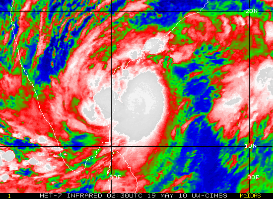
TC 02A has also formed in thre Arabian Sea.But, it will have no effect on the Sub-Continent coasts.It will enter the Gulf of Aden.As this gulf is cooled by the Somali current, the TC should weaken rapidly.
Satellite image (10.30pm Wednessday) of both the systems either side of India.

Readings as on 19th. May:
Hottest in Asia: Nawabshah (Pakistan) 49c.
Hottest in India: Akola (Maharashtra): 47.2cHottest Nights: Amraoti:33.8c, Chandrapur: 33.6c,Jodhpur: 33c,Khajuraho: 32.3c, Aurangabad: 32.2c,Jabalpur: 32c.(Now i'm not going below 32c).
Mumbai today, Colaba:34.8c, Santa Cruz:33.0c.
kapadias@gmail.com
The latest position of TC Laila is 14.3N 81.2E, that is 150 Kms. North-East of Chennai.Now,that is the nearest it has got to Chennai,and with the track turning North,it should strike land near Machillipatinum by tonite.
Maximum winds speed at 65Knts,and a core pressure of 986 mb,"Laila" maintains its Severe cyclone status.
But,after landfall, "Laila" is expected to weaken, and might not even reach the Orissa coast while tracking North-Eastwards.In fact,it is expected to dissipate within 72 hrs of landfall.
So,as Chennai starts clearing up from tomorrow evening,the brunt of the rains will be borne by coastal A.P,but not much penetrating in the interiors of the states.
Today,there was widespread rain in Tamil Nadu.Recording today morning, Chennai recieved 82 mms,Thiruvarur and Musiri 70 mms and various other stations between 30-50 mms.
After the "giant" dies down, and starts weakening,the south-west monsoon winds will re-organise in the Arabian Sea. The regular South-West monsoon moisture flow should start by the 22nd. of May,first into Sri lanka, followed by Kerala. As I discussed earliar,I expect this flow to start initially as a "rebound" to being subdued, and may last on for a few days on Kerala/Karnataka for the time being. The monsoon may take a small pause of 5/6 days at Karnataka coast.
TC 02A has also formed in thre Arabian Sea.But, it will have no effect on the Sub-Continent coasts.It will enter the Gulf of Aden.As this gulf is cooled by the Somali current, the TC should weaken rapidly.
Satellite image (10.30pm Wednessday) of both the systems either side of India.

Readings as on 19th. May:
Hottest in Asia: Nawabshah (Pakistan) 49c.
Hottest in India: Akola (Maharashtra): 47.2cHottest Nights: Amraoti:33.8c, Chandrapur: 33.6c,Jodhpur: 33c,Khajuraho: 32.3c, Aurangabad: 32.2c,Jabalpur: 32c.(Now i'm not going below 32c).
Mumbai today, Colaba:34.8c, Santa Cruz:33.0c.
kapadias@gmail.com
POSITION of "Laila" NEAR 13.6N 81.7E. Winds at 65 knts and pressure 974 mb.
TC 01B HAS RAPIDLY INTENSIFIED OVER THE PAST 24 HOURS (35 TO 65 KNOTS).ANIMATED WATER VAPOR IMAGERY INDICATES GOOD RADIALOUTFLOW.

FORECAST TO TURN NORTHWARD TO NORTH-NORTHEASTWARD NOW ONWARDS IN RESPONSE TO AN
APPROACHING W.D.
Note from a reader (Pradip):Chennai has BEEN BATTERED BY THE RAIN SINCE LAST EVENING, AND recorded 8.19 CM. And till now 12:27pm rainfall is continuing.
Rainrate will reduce towards late evening as "Laila" re-curves and moves North-North-East. Then the heavy rains would bre in the coastal A.P. regions. See actual rain map below.

Tuesday, May 18, 2010
Readings as on 18th. May:
The scene shifts from the Sub-Continent !
Hottest in Asia: Makkah (S.Arabia): 48c.
Hottest in India: Wardha (Maharashtra) 47.4c. Nagpur:46.2c,Satna:46c.
Hottest Nights: New Delhi(Palam): 34.0c,Chandrapur:34.0c,Kota:33.8c, Hissar:32.6c,Nagpur:32.0c,, New Delhi (S'Jung):32.0c,Jaipur:31.8c, Aurangabad (Maharashtra) 31.7c.
Mahableshwar hotter than Mumbai today !!
Mahableshwar max. 35.1c
Today's Mumbai day temps:Colaba:34.9c, S'cruz:35.5c.
Monsoon forecast: I think tthe Cyclone is moving as per the expectations in my blog written yesterday. Striking the coast near the A.P./Orissa border, and then sort of grazing it, and moving North-East. What happens to the Monsoon? My personal assumptions are:The energy gets sucked into the system, and suddenly we find a drop in the rain rate around the Andaman Islands.This will stall the further movement of the Bay branch, by 4/5 days. A lot of rain will move up the east coast during the next 4/5 days. Can this be called Monsoon rains? Technically no. And,subsequently, as the Bay waters will cool down a bit, fresh momentum required for the monsoon may take another week.Monsoon will advance into North-eastern region in the first week of June.
The Arabian Sea branch gets the initial pull from the cyclone,at the time the cyclone enters the land.Subsequently, the south-west flow of clouds and moisture can continue into Kerala uninteruppted. Hence, it is very possible, that regular monsoon winds can enter Kerala by the 25th./26th. Further movement Northwards may then take another week to gather momentum. The 200 hpa winds are not yet regrouped. The cyclone may have delayed this important parameter a bit,though their is no direct co-relation between the jet streams and the cyclone.

Monsoon movement into Karnataka and Northwards could be in the first week of June.
News from our Parntner Blog:
Joining up the pieces of atmospheric change
A well written article on the "warmth" coming up in the U.K. and the Indian region heat wave.
Update on TC "Laila":
Latest position at 13.3N 83.3E. With pressure dropped to 985mb and winds at 50 knts.

Possible area of striking coast near Kakinada,on 19th.evening, and then tracking along the East coast.As expected, it will turn to North-Northeast on hitting landmass.
Will strike the coast as Cat1 TC, and may maintain this intensity for at least 24/36 hrs. due to its proximity to the sea.Heavy supportive clouding seen in interior Karnataka.But this will vanish as the system moves away.
Rainfall upto 250 mms initially expected along A.P.coast, and 50-70 mms in interior A.P. and North T.N. coast.and winds will reach 70 knts aalong the shores.
Update of Cyclone:
Latest position is 12.4N 84.5E. That is 285 Nm east-southeast of Chennai. It has tracked west-northwest at 13 knots in the last 6 hrs.Peak winds are at 40 knots and gusts at 45 knts in the southeast and southwest quadrant. Pressure still at 996 mb. Likely to deepen now onwards.
Expected to take the North-North-west track initially, and later after 30 hrs. recurve in a North-Northeast direction. Might just be "on and off" the coast while just hitting the coast south of Vizag.Will graze the east coast after that while moving North-East.
Ofcourse, heavy rains along the path, and gusty winds and rough seas along the T.N. and A.P. coast with the movement of the cyclone will prevail.
Update on 01B:
The deep depression over southeast Bay of Bengal moved westwards since last observations,6 hrs. ago,intensified into a Cyclonic Storm ‘LAILA’,as per IMD status given, and lay centered at 0530 hrs IST of today,the 18 th May near Latitude 11.50N and 86.50E, about 700 km east-southeast of Chennai, 800 km southeast of Visakhapatnam.
The current winds are at 35 knots, 63 Kmph.and core pressure constant at 996 mb
Internationally, it is still in the "Tropical Storm" category. "TS" means winds upto 35 knts. Cat1 would mean the storm upgrading to "Cat 1" (severe cyclone) would be if winds are in the 34-63 Knts, 63-118 Kmph range.
This system is forecasted to reach Cat 1,or severe cyclone status within the next 36 hrs.
Expected movement will be North-West, initially. Strong possibilities of re-curving Northwards, or even North-East just before striking the coast.See Track from Tropical Storm Risk.

01B Update
No longer the Deep Depression, the Bay system, 01B. now has matured to TC status, and at 996 mb core pressure, and winds at 35 knots (on minute average),is situated at 11.8N and 86E, 420 NM South-East of Chennai, at 00Z 18th.May.

As the latest imagery of precipitation shows, its south-west quadrant is moisture heavy, and shows good signs of growth.
having tracked north-west till now, it should continue in the same direction initially, along the ridge which is steering it at present.
But, after 24 hrs, it may re-curve to the north-east direction, as it encounters a low trough aloft,(W.D.). This change of direction is totally based on the exact location of the W.D. then. It may turn and graze the coast as it moves on, or may just strike the coast at A.P. depends on the strenght and positioning of the trough aloft then.
NOGAPS and ECMWF theorise this scenario.
kapadias@gmail.com

Readings as on May 17th:
Hottest in Asia:
New Delhi (Palam) : 47.6c ..This is an all time high record for Palam for any month.And lots of other stations in India and Pakistan recording 46c,
Allahabad/Bamhrauli 46°
Nawabshah (Pakistan) 46°
Bahawalnagar (Pakistan) 46°
Pbo Raipur (India) 46°
Hissar Airport ( India) 46°
Satna (India) 46°
Nagpur Airport (India) 46°
Gwalior (India) 46°
Chhor (Pakistan) 46°
Kota Aerodrome (India) 46°
Hottest Nights: Kota: 35c, Chandrapur: 33c, Hissar:32c, Palam: 31c, Amrisar:31c (+9c), Jaipur:31c..and due to long list,upgraded the base level from 30c to 31c :)
Day temp of Mumbai,Colaba: 35.0c, S'Cruz: 34.2c
It’s a sizzling summer: A searing heat wave across India:
An IMD report says the heat across the Northern, Eastern and Southern regions had intensified as temperatures ranged up to 5/7c above normal.
The heat wave continued unabated in Northern India today, and has claimed more than 150 lives, and with temperatures touching the 48c and 47c mark at places in Rajasthan and Haryana.
With the mercury settling above the 45c mark at many places in Rajasthan, the desert state,Sriganganagar was the hottest place for the second consecutive day as it sizzled at a high of 47.8 degrees.
National capital New Delhi recorded maximum temperatures averaging 43c all through last week, and finally Palam topping 47.6c on Monday.
Wardha, Chandrapur and Brahmapuri in Maharashtra state have been the hottest city in the country as the temperature rose to a record 47 again, through last week.
As many as 22 people died heat-related deaths in southern Andhra Pradesh state since Thursday, PTI news agency reported. Hyderabad touched 45.5c.
In Punjab and Haryana, Hisar was the hottest in the region with a daytime temperature of 47c, 7c above normal.
In Gujarat,Ahmedabad saw a sharp rise in the maximum temperature and reportedly it was beyond 45c mark.
And finally for Mumbai: Municipal commissioner Swadhin Kshatriya said, “It is the worst situation in more than 100 years. The lake levels in Mumbai were never so low and wells have reached the lowest drawable levels at two places. We are exploring other sources such as borewells and have imposed water cuts. The city has enough water till July 15, but if the monsoon gets delayed, there could be problems.”
kapadias@gmail.com
Monday, May 17, 2010
Update on Bay System
Rightly said ! One of our readers has rightly said that the Bay has "bounced back." After sending negative signals throughout the last 1 month,in a rapid development, a low formed in the Bay on Sunday, and within 24hrs, now on Monday night, it is a deep depression.
A deep depression yes, but the core pressure is at 1000 mb, and the wind speed at the centre is 30 knots.
Now, the IMD forecasts it to move North-West, and deepen into a cyclonic storm, to cross the A.P. coast by the 20th.
JTWC estimates it to be a depression, and is still not declared its point of crossing the coast.
ECMRWF estimates a depression to move along the East coast, and cross the coast at Orissa.
I would personally go by that estimate. The said depression/deep depression would eventually move towards the A.P. coast till the 19th, and then graze the coast ,and cross maybe somewhere at the Orissa/ W.Bengal coast by the 23rd. That's my personal view point, and in weather, one can never be too sure or accurate. My reasoning for the system's "along the coast" movement is the W.D. moving in the Northern regions of the country. This W.D.aloft, can push the depression off course, and steer it into Orissa/ W.Bengal coast.
But things can appear and disappear in the weather mechanism within a day.
So if the W.D. vanishes.....things can be different. Therefore,alongwith paying attention to this depression, I would be focused on the W.D.s up North.
Resultantly, the Monsoon has moved into the middle Andaman regions.
Now, we wait and watch for its further progress here.
For T.N. heavy rains will commence once this system approaches the coast. Then it all depends on its steering course.
For Kerala, heavy precipitation on Wednessday/Thursday, till the effect of the system is intact. Then again ...depends..? IMD may advance the Monsoon into Kerala during this period, but I woulds be cautious. If the system crosses into T.N.or A.P. and re-emerges into the Arabian Sea, it might just pull off the Monsoon energy Northwards or North-Westwards.
Situation is too fluid now..but will monitor, and update this blog frequently from tomorrow, at 4/6 hourly intervals.
Sunday, May 16, 2010
Readings as on 16th. May:
Hottest in Asia: Larkana (Pakistan): 50c. Also,Nawabshah:49c,Jacobabad:48c (Pakistan).Hottest in India: Ganganagar:47.8c,Hissar 47c,
Hottest Nights (above 30c): Jodhpur 31.6c,Kota 32.3c, Raipur 32.0c,
Mahableshwar:32.2c, Simla 29.2c.
Mumba,Colaba:35.8c, Mumbai,S'Cruz:34.0c.Thane (AWS) 36.0c.
Warm weather with temperatures around 35c in the day for Mumbai. Cloudiness increasing from Wednessday.
For Mumbai Readers:TOI Front page news today( Sunday) says Mumbai touches 40c.recorded in April and March!Totally misleading and unproffesional, just ignore.
The Heat is ON ! The first 50c of the year was recorded in Larkana, Pakistan, today.
The entire stretch from Sindh (Pakistan) into India covering the states of Rajasthan, Haryana, Delhi, M.P, Vidharbh and Gujarat are under a severe heat wave. IMD map of today's high shows the deep red area covering the region.
The entire stretch from Sindh (Pakistan) into India covering the states of Rajasthan, Haryana, Delhi, M.P, Vidharbh and Gujarat are under a severe heat wave. IMD map of today's high shows the deep red area covering the region.

Nawabshah (Pakistan) 49°
Jacobabad ( Pakistan) 48°
Hissar Airport (India) 47°
Brahmpuri (India) 46
Wardha (India) 46
Nagpur Airport (India) 46°
Satna (India) 46°
Bahawalnagar (Pakistan) 46°
Bikaner Airport (India) 46°
Gwalior (India) 46°
Chhor (Pakistan) 46°
Khanpur (Pakistan) 46°
The Sub-Continent list of over 46s is long today. And I must have missed out a few .In addition, there are 45s today too !
This intense heat will give be a booster for the fast formation and deepening of the seasonal low over the Sindh/ Rajasthan region, and its spreading into the heart of India in the East, and Westwards into Pakistan and Iran.
The North-South trough runs through from East Madhya Pradesh to south Tamilnadu across Vidarbha, Marathawada and Karnataka, hence the line of wind discontinuity persists.
North-East India has been enjoying much cooler weather, with pre-monsoon showers. All stations in this region have rain in excess for the pre monsoon season. Cherrapunji,the wet spot, has recieved 4277 mms of rain in March and April, which is 2766 mms more than the normal for this period !!
We see the low in the Bay, mentioned in yesterday's blog,taking shape and the cloud mass increasing. But,I see the system pulling the clouds from the Andaman Islands,and weakening the monsoon current there to some extent.
Conclusion: The Monsoon will advance into Andaman Islands within 2 days, but the Bay branch may stagger later. Arabian Sea branch? Like we discussed earliar, I feel it depends on the direction the depression takes after it crosses the T.N. coast. There are too many ifs and buts to this sector.
News from my Partner Blog: A superb write up on the " Summer Heat & Daily downpours showing in prime areas" Please read it and see how the other regions of the globe are facing summer, while Spain and the U.K. are "cooling Off ".
kapadias@gmail.com
Subscribe to:
Posts (Atom)
7th May

-
 Wettest Monsoon Day in 2013 for maharashtra...See pradeep's Page BB-4 lingers on, and on Tuesday, was located as a weak low over N...
 -
Pune recorded 87 mm ending 8.30am today. With this achieved 1000 mm mark! Seasonal Rainfall stands on 1018 mms now. Last night Widespread...
