Co Authors: GSB, Shreyas Dhavale, Pradeep John, Dr. Vineet Singh, Gokul
Author's Page
The notable meteorological point is that 50°C temperatures are not a new phenomenon in the India–Pakistan region. The Sindh belt has been recording such values for decades, and Rajasthan has periodically approached or crossed the mark during strong pre-monsoon heating years.
.
This is why Vagaries often emphasizes that while climate trends are important, a 50°C reading by itself is not unprecedented in the historical records of northwest India and Pakistan.
-----------------------------
How Reliable are Climate Models.
Courtesy Roy Spencer Blog
At a glance
So, what are computer models? Computer modelling is the simulation and study of complex physical systems using mathematics and computer science. Models can be used to explore the effects of changes to any or all of the system components. Such techniques have a wide range of applications. For example, engineering makes a lot of use of computer models, from aircraft design to dam construction and everything in between. Many aspects of our modern lives depend, one way and another, on computer modelling. If you don't trust computer models but like flying, you might want to think about that.
Computer models can be as simple or as complicated as required. It depends on what part of a system you're looking at and its complexity. A simple model might consist of a few equations on a spreadsheet. Complex models, on the other hand, can run to millions of lines of code. Designing them involves intensive collaboration between multiple specialist scientists, mathematicians and top-end coders working as a team.
Modelling of the planet's climate system dates back to the late 1960s. Climate modelling involves incorporating all the equations that describe the interactions between all the components of our climate system. Climate modelling is especially maths-heavy, requiring phenomenal computer power to run vast numbers of equations at the same time.
Climate models are designed to estimate trends rather than events. For example, a fairly simple climate model can readily tell you it will be colder in winter. However, it can’t tell you what the temperature will be on a specific day – that’s weather forecasting. Weather forecast-models rarely extend to even a fortnight ahead. Big difference. Climatetrends deal with things such as temperature or sea-level changes, over multiple decades. Trends are important because they eliminate or 'smooth out' single events that may be extreme but uncommon. In other words, trends tell you which way the system's heading.
All climate models must be tested to find out if they work before they are deployed. That can be done by using the past. We know what happened back then either because we made observations or since evidence is preserved in the geological record. If a model can correctly simulate trends from a starting point somewhere in the past through to the present day, it has passed that test. We can therefore expect it to simulate what might happen in the future. And that's exactly what has happened. From early on, climate models predicted future global warming. Multiple lines of hard physical evidence now confirm the prediction was correct.
Finally, all models, weather or climate, have uncertainties associated with them. This doesn't mean scientists don't know anything - far from it. If you work in science, uncertainty is an everyday word and is to be expected. Sources of uncertainty can be identified, isolated and worked upon. As a consequence, a model's performance improves. In this way, science is a self-correcting process over time. This is quite different from climate science denial, whose practitioners speak confidently and with certainty about something they do not work on day in and day out. They don't need to fully understand the topic, since spreading confusion and doubt is their task.
Climate models are not perfect. Nothing is. But they are phenomenally useful.
-------------------------------------------
In the real-world, people don’t experience climate as yearly or monthly temperature anomalies, they experience weather on a day to day basis, where one day may be abnormally warm, and another might be abnormally cold. Sometimes new records are set on such days. This is normal, but such records are often portrayed by the media as being evidence of “climate change” when if fact it is nothing more than natural variations of Earth’s atmosphere and weather systems. In fact, is doubtful humans would even notice the mild warming we’ve had in the last century at all, given that the human body often can’t tell the difference between 57°F and 58°F in any given moment, much less over a long term.
Essentially, what we know as climate change is nothing more than a man-made statistical construct. You can’t go outside and hold an instrument in the air and say “I’m measuring the climate.” Climate is always about averages of temperature over time. It’s a spreadsheet of data where daily high and low temperatures are turned into monthly averages, and monthly averages are turned into yearly averages, and yearly averages are turned into graphs spanning a century.
But, such graphs used in press releases to the media and broadcast to the public don’t really tell the story of the data honestly. They omit a huge amount of background information, such as the fact that in the last 40 years, we’ve had a series of El Niño weather events that have warmed the Earth; for example, 1983, 1998 and in 2016. The two biggest El Niño events are shown coinciding with temperature increases in Figure 3.
Figure 3. GISTEMP global temperature data, in 12-months running average (anomalies relative to the first 30 years). Source: RealClimate.org
These graphs also don’t tell you the fact that much of the global surface temperature measurements are highly polluted with Urban Heat Island (UHI) and local heat-sink related siting effects that bias temperatures upward, such as the wholesale corruption of climate monitoring stations I documented in 2022, where 96% of the stations surveyed don’t even meet published standards for accurate climate observations. In essence – garbage in, garbage out.
But, all that aside, the main issue is how the data is portrayed in the media, such as The Guardian example shown in Figure 2.
To that end, I have prepared a new regular feature on WUWT, that will be on the right sidebar, combined with the long-running monthly temperature graphs from the state of the art (not polluted or corrupted) NOAA operated U. S. Climate Reference Network and the University of Alabama Huntsville (UAH) satellite derived temperature global record
In this calculation, the “normal” temperature of the Earth is assumed to be 57.2°F. and that is simply added to the anomaly temperature reported by NASA GISS to obtain the absolute temperature.
There is no such phenomena as anthropogenic climate change because most of the earth is water, rocks, sand, ice and snow. Activities of humans are not going to effect the climate of the vast Pacific ocean, the Andes mountains or the Sahara desert. However, activities of humans in urban areas can effect local climate due to the UHI effect. In some countries, humans can cause local desertification by stripping the land of plants for firewood and for food for animals.
One extreme weather event are Atlantic hurricanes , the frequency of which has greatly declined since 1900. So far this hurricane season has been a bust.
Death Valley World Record of 134 deg. F Debunked in New Paper
Several meteorologists over the years have questioned the plausibility of the 134 deg. F world record hottest temperature recorded at Greenland Ranch, California, on July 10, 1913, but quantitative evidence has been lacking. We used 100 years of temperatures recorded at higher-elevation (and thus cooler) locations to find a range of temperatures that most likely occurred on that date.
The answer was 120 (+/-2) deg. F, typical for Death Valley in July, and well below the world record value of 134 deg. F. I have previously blogged on the evidence against this value and how and why it might have been recorded.
While I remain a skeptic of anthropogenic climate change being a net threat to human health and welfare, unlike some other skeptics I have never considered a temperature on a single day (especially over 100 years ago) as being any kind of evidence related to climate change. We follow the data, which is what we did in this new study.
Sea Ice Data Cut-off: Climate Alarmists Panic, But Is It Really a Crisis?
I’ve spent years at Watts Up With That debunking the overhyped narratives surrounding climate science, particularly the obsession with sea ice as a supposed “canary in the coal mine” for global warming. The recent Space.com article, dated July 10, 2025, titled “US military cuts climate scientists off from vital satellite sea-ice data,” has predictably stirred up alarmist rhetoric about the loss of data from the Special Sensor Microwave Imager/Sounder (SSMIS) operated by the Department of Defense.
The article claims this move blinds scientists to a critical climate indicator, but let’s take a step back and examine why this might not be the catastrophe it’s made out to be—and why sea ice data, in the grand scheme, isn’t the climate proxy it’s cracked up to be. The Space.com piece details how the National Snow and Ice Data Center (NSIDC) at the University of Colorado, Boulder, will lose access to SSMIS data, which tracks sea ice coverage. The article paints this as a devastating blow, tying sea ice loss to catastrophic glacier melting and sea level rise, while also noting commercial benefits like shorter shipping routes.
Sea ice has long-been a poster child for climate alarmism, but as we’ve discussed extensively at WUWT it’s a flawed and noisy proxy for climate change. First off, Arctic sea ice, while lower than its 1979-2000 average, has not vanished as predicted. Since the notable low in 2007, Arctic sea ice extent has stabilized at a new, lower plateau, fluctuating year to year but showing no consistent downward spiral toward an “ice-free Arctic” summer, despite endless model-based forecasts and bloviations from Al Gore.
Figure 1: Shows satellite derived summer minimum Arctic Sea ice extent values from 1979 to 2023, with dashed line showing the linear trend. The added trend line in red shows no change in summer minimum extent since 2007. Image source: NSIDC. Red trend line from 2007 and trend line examples under the title added by A. Watts
For example, we’ve covered how Arctic sea ice has remained stable for nearly 20 years. Meanwhile, Antarctic sea ice tells an even more inconvenient story. Contrary to models predicting ice loss in a warming world, Antarctic sea ice has shown periods of growth, particularly in recent years. We reported on this in 2014, noting that Antarctic sea ice reached a new record high extent. This growth directly contradicts the narrative that a warmer planet universally melts sea ice, exposing the oversimplification of tying ice extent to global temperature.
it’s influenced by far more than just temperature. Wind patterns, ocean currents, and natural variability like the Arctic Oscillation play massive roles. For instance, we’ve discussed how changes in wind patterns affect Antarctic sea ice. In Antarctica, changes in atmospheric circulation, not just temperature, drive ice variability.
In short, the Space.com article is another example of climate alarmism dressed up as science. Sea ice isn’t the climate oracle it’s made out to be, and the loss of SSMIS data is more inconvenience than catastrophe. Arctic ice has stabilized, Antarctic ice has grown, and natural variability trumps simplistic warming narratives.
The bottom line: Tracking daily sea ice provides, at best, a rough indication of what’s happening in the polar regions, heavily filtered by natural variability and technical limitations. For actual climate science, it’s a highly indirect, noisy, and unreliable metric—one that tells us less about the climate than about the limitations of our models and the persistent urge to find a simple answer to a complex system. The scientific value is, therefore, minimal—especially when compared to the breathless importance often assigned to it.
In sum: Sea ice measurements have niche utility, but they are no oracle for climate or policy. Their scientific value, outside of specialized polar research, is overstated and often used as a proxy for arguments that lack better evidence.
Why Is It Getting Colder If The Earth Is Getting Hotter Due To "Global Warming"
Despite global warming, North India faces intense cold due to natural phenomena like the polar vortex. The disrupted climate system sends cold air southward, affecting the jet stream and causing severe cold outbreaks. This simple explanation highlights how regional weather complexities, influenced by global warming, lead to unexpected and harsh winter conditions.
It's because of air circulation. In the polar zones, air circulates rapidly in a circular shape, keeping those areas extremely cold. Meanwhile, hot areas experience subtropical jet streams. In a normal situation without global warming, these winds would flow balanced. But with higher temperatures, the speed of cold winds in polar zones
The weakened cold winds expand, reaching polar zones. The cold air weakens and flows toward warmer areas, creating a climate system called the polar vortex. This system impacts India, bringing Western Disturbance due to the pressure of cold air in Central Asia. The cold air enters India from the west, making North India exceptionally cold.
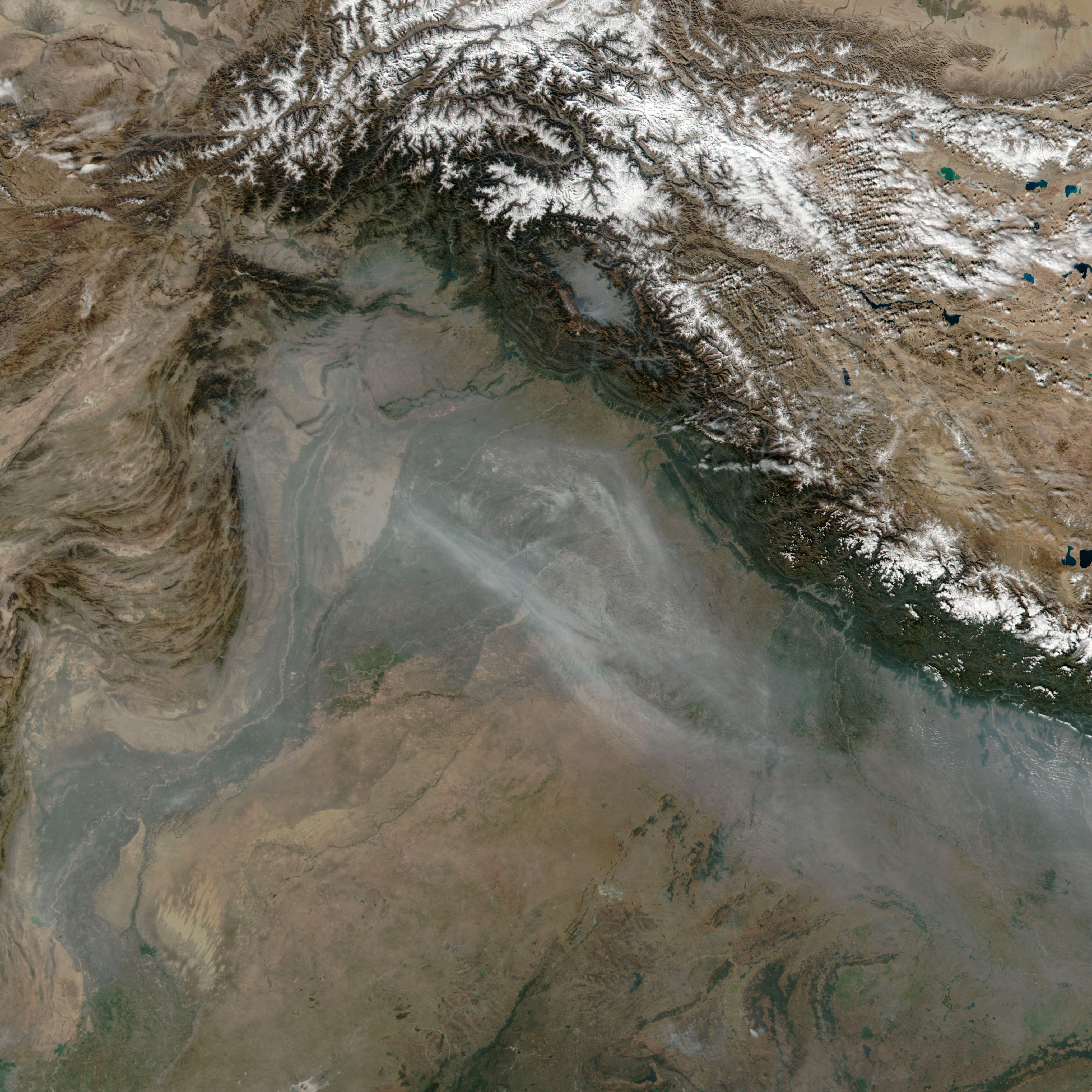
Every November, satellites detect large numbers of small smoke plumes and heightened fire activity in northern India and Pakistan as farmers burn off excess straw after the rice harvest. Many farmers, particularly in the Punjab region, use fire as a fast, inexpensive way to clean up fields before planting winter wheat crops. However, the influx of smoke to the densely populated Indo-Gangetic Plain often contributes to a sharp deterioration of air quality in October and November.
Levels of air pollution soared during the last week of October and first week of November in 2024 as weather patterns kept air bottled up in the Indo-Gangetic Plain. On November 3, 2024, the VIIRS (Visible Infrared Imaging Radiometer Suite) on the Suomi NPP satellite acquired this natural-color image of plumes of smoke streaming from large numbers of small fires burning in Pakistan and India.
Air quality sensors in Lahore, Pakistan, recorded concentrations of fine particulate matter (PM2.5) at hazardous levels—above 300 on the air quality index (AQI)—on several days in October and November, according to data posted by AirNow.
U.N. Predicts Disaster if Global Warming Not Checked
PETER JAMES SPIELMANNJune 30, 1989
UNITED NATIONS (AP) _ A senior U.N. environmental official says entire nations could be wiped off the face of the Earth by rising sea levels if the global warming trend is not reversed by the year 2000.
Coastal flooding and crop failures would create an exodus of ″eco- refugees,′ ′ threatening political chaos, said Noel Brown, director of the New York office of the U.N. Environment Program, or UNEP.
He said governments have a 10-year window of opportunity to solve the greenhouse effect before it goes beyond human control.
As the warming melts polar icecaps, ocean levels will rise by up to three feet, enough to cover the Maldives and other flat island nations, Brown told The Associated Press in an interview on Wednesday.
Coastal regions will be inundated; one-sixth of Bangladesh could be flooded, displacing a fourth of its 90 million people. A fifth of Egypt’s arable land in the Nile Delta would be flooded, cutting off its food supply, according to a joint UNEP and U.S. Environmental Protection Agency study.
″Ecological refugees will become a major concern, and what’s worse is you may find that people can move to drier ground, but the soils and the natural resources may not support life. Africa doesn’t have to worry about land, but would you want to live in the Sahara?″ he said.
UNEP estimates it would cost the United States at least $100 billion to protect its east coast alone.
Shifting climate patterns would bring back 1930s Dust Bowl conditions to Canadian and U.S. wheatlands, while the Soviet Union could reap bumper crops if it adapts its agriculture in time, according to a study by UNEP and the International Institute for Applied Systems Analysis.
Excess carbon dioxide is pouring into the atmosphere because of humanity’s use of fossil fuels and burning of rain forests, the study says. The atmosphere is retaining more heat than it radiates, much like a greenhouse.
The most conservative scientific estimate that the Earth’s temperature will rise 1 to 7 degrees in the next 30 years, said Brown.
The difference may seem slight, he said, but the planet is only 9 degrees warmer now than during the 8,000-year Ice Age that ended 10,000 years ago.
Brown said if the warming trend continues, ″the question is will we be able to reverse the process in time? We say that within the next 10 years, given the present loads that the atmosphere has to bear, we have an opportunity to start the stabilizing process.″
He said even the most conservative scientists ″already tell us there’s nothing we can do now to stop a ... change″ of about 3 degrees.
″Anything beyond that, and we have to start thinking about the significant rise of the sea levels ... we can expect more ferocious storms, hurricanes, wind shear, dust erosion.″
He said there is time to act, but there is no time to waste.
UNEP is working toward forming a scientific plan of action by the end of 1990, and the adoption of a global climate treaty by 1992. In May, delegates from 103 nations met in Nairobi, Kenya - where UNEP is based - and decided to open negotiations on the treaty next year.
Nations will be asked to reduce the use of fossil fuels, cut the emission of carbon dioxide and other greenhouse gases such as methane and fluorocarbons, and preserve the rain forests.
″We have no clear idea about the ecological minimum of green space that the planet needs to function effectively. What we do know is that we are destroying the tropical rain forest at the rate of 50 acres a minute, about one football field per second,″ said Brown.
Each acre of rain forest can store 100 tons of carbon dioxide and reprocess it into oxygen.
Brown suggested that compensating Brazil, Indonesia and Kenya for preserving rain forests may be necessary.
The European Community istalking about a half-cent levy on each kilowatt- hour of fossil fuels to raise $55 million a year to protect the rain forests, and other direct subsidies may be possible, he said.
The treaty could also call for improved energy efficiency, increasing conservation, and for developed nations to transfer technology to Third World nations to help them save energy and cut greenhouse gas emissions, said Brown.
U.N. Predicts Disaster if Global Warming Not Checked
PETER JAMES SPIELMANNJune 30, 1989
UNITED NATIONS (AP) _ A senior U.N. environmental official says entire nations could be wiped off the face of the Earth by rising sea levels if the global warming trend is not reversed by the year 2000.
Coastal flooding and crop failures would create an exodus of ″eco- refugees,′ ′ threatening political chaos, said Noel Brown, director of the New York office of the U.N. Environment Program, or UNEP.
He said governments have a 10-year window of opportunity to solve the greenhouse effect before it goes beyond human control.
As the warming melts polar icecaps, ocean levels will rise by up to three feet, enough to cover the Maldives and other flat island nations, Brown told The Associated Press in an interview on Wednesday.
Coastal regions will be inundated; one-sixth of Bangladesh could be flooded, displacing a fourth of its 90 million people. A fifth of Egypt’s arable land in the Nile Delta would be flooded, cutting off its food supply, according to a joint UNEP and U.S. Environmental Protection Agency study.
″Ecological refugees will become a major concern, and what’s worse is you may find that people can move to drier ground, but the soils and the natural resources may not support life. Africa doesn’t have to worry about land, but would you want to live in the Sahara?″ he said.
Shifting climate patterns would bring back 1930s Dust Bowl conditions to Canadian and U.S. wheatlands, while the Soviet Union could reap bumper crops if it adapts its agriculture in time, according to a study by UNEP and the International Institute for Applied Systems Analysis.
Excess carbon dioxide is pouring into the atmosphere because of humanity’s use of fossil fuels and burning of rain forests, the study says. The atmosphere is retaining more heat than it radiates, much like a greenhouse.*
The most conservative scientific estimate that the Earth’s temperature will rise 1 to 7 degrees in the next 30 years, said Brown.
The difference may seem slight, he said, but the planet is only 9 degrees warmer now than during the 8,000-year Ice Age that ended 10,000 years ago.
Brown said if the warming trend continues, ″the question is will we be able to reverse the process in time? We say that within the next 10 years, given the present loads that the atmosphere has to bear, we have an opportunity to start the stabilizing process.″
He said even the most conservative scientists ″already tell us there’s nothing we can do now to stop a ... change″ of about 3 degrees.
″Anything beyond that, and we have to start thinking about the significant rise of the sea levels ... we can expect more ferocious storms, hurricanes, wind shear, dust erosion.″
He said there is time to act, but there is no time to waste.
International Women's Day is an occasion to remember and celebrate talented female scientists from across the world. Today we pay a small tribute to the most distinguished Indian female meteorologist - Miss Anna Modayil Mani.
Miss Mani was born on Aug. 23, 1918 in Kerala, studied and researched in Chennai, Bengaluru and London. She was a student of CV Raman and later served as the deputy director general of the Indian Meteorological Department.
Her contribution to ensuring self-reliance in measuring aspects of weather is considered her biggest achievement for independent India.
She focused on accuracy of Indian weather measurement instruments for solar radiation and wind strength hence laying a solid foundation for today's solar and wind power as alternative sources of energy.
Anna Mani has also led a team of scientists who developed the Indian ozonesonde, a balloon-borne instrument to measure ozone levels as early as in 1967. The collected data became a real treasure to identify the dangerous changes in the atmosphere.
Happy international Women's Day!
Being a woman scientist at has been a great challenge which Anna Mani overcame with ease and firmness. We salute all the Indian women scientists of yesteryears and look forward to see many more in the future. Happy International Women's Day!
UNITED NATIONS (AP) _ A senior U.N. environmental official says entire nations could be wiped off the face of the Earth by rising sea levels if the global warming trend is not reversed by the year 2000.
Coastal flooding and crop failures would create an exodus of ″eco- refugees,′ ′ threatening political chaos, said Noel Brown, director of the New York office of the U.N. Environment Program, or UNEP.
He said governments have a 10-year window of opportunity to solve the greenhouse effect before it goes beyond human control.
As the warming melts polar icecaps, ocean levels will rise by up to three feet, enough to cover the Maldives and other flat island nations, Brown told The Associated Press in an interview on Wednesday.
Coastal regions will be inundated; one-sixth of Bangladesh could be flooded, displacing a fourth of its 90 million people. A fifth of Egypt’s arable land in the Nile Delta would be flooded, cutting off its food supply, according to a joint UNEP and U.S. Environmental Protection Agency study.
THE 300 / 200 MB CHART METEOROLOGIST JEFF HABY One of a forecaster's first thoughts when confronted with the 300/200 mb chart is the jet stream. The jet stream is a high velocity river of air that flows completely around the Earth at the mid-latitudes. During winter, the jet core is located generally closer to 300 millibars since the air is more cold and dense in the vicinity of the jet stream during the cool season. The 200 millibar chart is used for the jet stream in the warm season but either chart in most instances will suffice. Many hot air balloonists have tried to ride this river of air around the world with not much success for most. The river of air is not continuous. Embedded within the jet stream are higher velocity jet streaks. Jet streaks are segments of faster wind speed within the jet stream. At 300 mb, the air density is much smaller than near the surface. A 100-knot wind at the 200/300 millibar level does not feel as strong as a 100 knot wind at the surface. Even though the density is smaller, these air currents have the power to drive the movement of storm systems and build troughs and ridges. One jet streak can turn a beautiful Monday into a severe storm Tuesday, as we will see in an example later. Troughs and ridges are not only carved by warm air and cold air advection but also by the high momentum air of jet streaks. A significant jet streak has winds over 100 knots. Look at the 300 mb chart in this section labeled "Time 1". A jet streak exists from Colorado to Montana. The highest wind speeds in the jet streak (aka jet core, jet surge) are 130 knots (150 miles per hour) in southern Wyoming. Parcels within the jet streak are diving to the southeast. The air's momentum forces a trough to develop across the Central US. In "Time 2", the chart from 12 hours later, the jet streak has moved further to the southeast and the associated trough is becoming more amplified. At "time 3" the jet streak has turned the corner and is in the base of the trough. The trough is at maximum amplification. The trough will now move to the east and eventually to the northeast. It is difficult to determine the four quadrants of a jet streak when one "turns the corner". Divergence and rising motion are strongest to the north of the jet axis, such as in Tennessee during highly curved jet streaks. RULE OF THUMB: If a jet streak exists on the left side of a trough and winds are stronger to the left of the trough (as it is in our example in "Time 1"), the trough will become more amplified with time and will "dig" in a southerly direction. If a jet streak exists on the right side of a trough and winds are stronger to the right of the trough, the trough will become less amplified with time and "lift out" in a northeasterly direction. If the winds are about the same on each side of the trough, it will stay at about the same amplification. This knowledge will make you a better forecaster! A jet streak progression is shown below. The jet stream is useful for the prediction of temperature. The jet stream divides colder air to the north from warmer air to the south. The transition between temperatures on each side of the jet is very abrupt. Heights are higher to the south of the jet and lower to the north. In the upper levels, this creates relatively high heights to the south of the jet and relatively low heights to the north. The Pressure Gradient Force flows from a southerly to northerly direction. However, the Coriolis force shifts the wind flow to the right of the path of motion. Therefore, the jet stream flows from the west to east. When a trough builds over a region it often indicates cooler temperatures due to cloudier weather and northerly winds. A ridge builds by low level (between the surface and 700-mb) warm air advection and upper level forcing (negative vorticity). Air in a ridge is sinking and is thus expanding and creating higher heights. Therefore, temperatures are warmer than normal in a ridge due to warmer temperatures and sunnier weather. This is especially true when a ridge occurs in high latitudes. Below is a diagram showing the development of the polar jet and the wind pattern the PGF and Coriolis produce. Certain regions of jet streaks are more favorable for rising or sinking air. Where convergence occurs in the upper levels, sinking motion results. Where divergence (evacuation of mass) occurs in the upper levels, rising motion result. Convergence and divergence in a jet streak is caused by an imbalance of forces as a parcel accelerates into a jet streak then decelerates out of the jet streak. The depiction below shows the balance and imbalance of forces in a jet streak. Lets look at each of the 5 numbers and letters. MOTION WITHIN A JET STREAK (1) Pressure Gradient Force and Coriolis are in balance. Wind is geostrophic (parallel to height contours) (2) Parcel enters region of higher wind speed. This increases the Pressure gradient force at the same time the Coriolis has not been changed much. Wind will tend to flow toward the longest vector, which is the PGF. This causes convergence in the Left Rear Quad (sinking air at letter A) and divergence in the Right Rear Quad (rising air at letter D). The tropopause is just above jet stream level. Convergence at the jet stream level forces air to sink because the highly stable tropopause prevents air from rising. (3) The Coriolis once again balances the Pressure Gradient Force. (4) As a parcel leaves the jet streak it must decelerate. The Pressure Gradient Force weakens at the same time the Coriolis has not had time to adjust and decrease. This causes convergence in the Right Front Quad (sinking air at letter B) and divergence in the Left Front Quad (rising air at letter C). (5) Pressure Gradient Force and Coriolis once again balance This example has been for a jet streak in a zonal flow. A jet streak in a curved flow, such as the case when a jet streak is in the base of a trough, will have divergence and rising air to the north of the jet and convergence and sinking air to the south of the jet. The jet stream is a powerful forecasting tool. Not that it can give exact highs/ lows/ and precipitation chances, but because it gives information such as when to expect the next storm system and whether temperatures will be above or below normal. It gives clues to how the upper levels will promote rising air or sinking air. It gives clues to the character of the next storm system. Jet streaks alone provide much information of how a trough or ridge will develop over the next couple of days. WHAT TO LOOK FOR ON 300/250/200 chart: (1) Jet stream *The jet stream is a river of air with segments of higher speed winds embedded within the mean flow *Areas North of jet stream tend to have cooler than normal temperatures especially in the mid-latitudes *Areas South of jet stream tend to have warmer than normal temperatures, especially in higher latitudes (2) Jet Streaks *Rising air occurs in the right rear and left front quadrants of jets *Sinking air occurs in the left rear and right front quadrants of jets *Rising air occurs north of jet axis if jet is in a highly curved flow *Winds over 120 miles per hour constitute a significant jet streak *Upper level divergence enhances rising air, especially if warm air advection is occurring in lower levels of atmosphere (3) General trough/ridge pattern *Momentum of jet stream carves the trough ridge pattern. If the jet stream winds are greater on the LEFT side of a trough, the trough will become more amplified and move further south. If the jet stream winds are greater on the RIGHT side of a trough, the trough will become less amplified with time and move further north.
Heat Wave & Cold Wave Criteria: Hot Day: Whenever the maximum temperature remains 40o
C or more
and minimum remains 5o
C or more above normal, provided, it
is not satisfying the heat wave criteria. Heat wave Departure of maximum temperature from normal is + 4o
C to
+ 5o
C or more for the regions where the normal maximum
temperature is more than 40o C and departure of maximum
temperature from normal is + 5o
C to + 6o
C for regions where
the normal maximum temperature is 40o
C or less
(Heat Wave is declared only when the maximum temperature
of a station reaches at least 40O
C for plains and at least 30O
C for Hilly regions).
When actual maximum temperature remains 45°C or more
irrespective of normal maximum temperature, heat wave is
declared. Severe heat wave conditions Departure of maximum temperature from normal is +6 OC or
more for the regions were the normal maximum temperature
is more than 40 OC and +7 OC or more for regions were the
normal maximum temperature is 40 OC or less.
(Heat Wave is declared only when the maximum temperature
of a station reaches at least 40O
C for plains and at least 30O
C for Hilly regions) Cold Day In the plains of north India, foggy conditions prevail during
winter for several days or weeks. The minimum temperature
on these days remains above normal, while maximum
temperature remain much below normal. This creates cold
conditions for prolonged period.
When maximum temperature is less than or equal to 16°C in
Plains, it will be declared “Cold Day”. Cold Wave Wind chill factor is taken into account while declaring the cold
wave situation.
The wind chill effective minimum temperature (WCTn) is
defined as the effective minimum temperature due to wind
flow. For ex. When the minimum temperature is 15 OC and the
6
wind speed is 10 mph, WCTn will be 10.5 OC.
Departure of WCTn from normal minimum temperature is from
–5
oC to–6
oC where normal minimum temperature > 10oC and
from –4
oC to –5
oC elsewhere, Cold Wave is declared.. For
declaring cold wave etc. WCTn only is used and when it is
< 10OC only, cold wave is considered (this criteria does not
hold for coastal stations).
Also cold wave is declared when WCTn is < 0oC irrespective
of the normal minimum temperature for those stations. Severe cold wave Departure of WCTn from normal minimum temperature is –7
oC
or less for the regions where normal minimum temperature is
> 10oC and –6
oC or less elsewhere. (departure of WCTn from
normal minimum temperature is from –5
oC to
–6
oC where normal minimum temperature > 10oC and from –
4
oC to –5
oC elsewhere) Computer Forecasts The forces, or if you like, the equations governing the weather are also non-linear. Over short timescales, weather can be quite predictable, but over longer timescales, very small variations in conditions can produce dramatically different outcomes. MIT physicist Edward Lorenz found this in modeling weather systems on a computer. He found that if he changed the least significant bit of the input that designates the starting point, he obtained dramatically different results. In finding this exquisite sensitivity to tiny changes in the initial conditions, Lorenz asked the famous question, “Does the flap of a butterfly’s wings in the Brazil set off a tornado in Texas?”
Therein lies an intrinsic limitation on predictability. Our computers cannot possibly capture every tiny detail of the temperatures, pressures, and wind speeds at every point on the earth, so the inputs are necessarily imprecise. Since the forces governing weather are intrinsically non-linear, the resulting predictions only have so much precision that we can be assured of, and forecasts are generally not very good for more than five days in advance.
In point of fact, the local observer can often out-do computer forecasts, because you, the observer can witness the behavior of weather on shorter distance scales and shorter timescales than the networks of sensors, or the distances over which the computers must average the behavior of weather. You, the observer, in many ways can often outdo the computer models by taking careful observations locally.
What is a Drought Year ? With 7.6% Deficient (All India), would 2012 be termed as a drought Year ?..27th March 2013 (comments on that page) Droughts in India has resulted in tens of millions of deaths over the course of the 18th, 19th, and 20th centuries. Indian agriculture is heavily dependent on the Monsoons in India: a favorable southwest summer monsoon is critical in securing water for irrigating Indian crops. Some of the major drought-prone regions are southern and eastern Maharashtra, northern Karnataka, Andhra Pradesh, Orissa, Gujarat, Bengal, Bihar and Rajasthan. But why has this been repeatedly happening since the last 200 years? 200 years is a long enough period given to overcome the situation and prevent the people's suffering by providing adequate means and inter regional water storage and transfer. And knowing the weather, it is almost natural, that either of the above mentioned regions is bound to get below normal deficient rainfall in any year. Do we literally have to wait for a surplus rainfall in each and every region of the country. If yes, than thats poor management and governance of water resources. We should be capable with providing the shortfall by the excess available in some other region. Nature's bounty is always merciful on us, but are we ever ready? Do we know how to store and preserve water, rather than just let it drain in the two seas on either side. Most of the SWM rains drain off in the seas. Is India really water starved ? This article ( July 2012) published in Vagaries is most apt and suited for the topic under discussion....and the article ended with ..otherwise .....Otherwise we see the same old story in parts of the country today.
Then what is a drought Year ? Was 2012 a drought Year ? Out of the total 36 meteorological subdivisions, 23 subdivisions constituting 67.3% of the total area of the country received excess/normal season rainfall and the remaining 13 subdivisions (32.7% of the total area of the country) received deficient season rainfall.
To really analyse the "drought" situation this year, let us take into consideration of the five Peninsula states... TN, Kerala, Gujarat, Maharashtra and Karnataka, which, the officials tell us are the worst effected... Karnataka: End Season, Coastal Karnatak was 0%, N.I.Karnataka was -36% and S.I.Karnataka was -23%. Average deficiency for the state: -19.6%. Maharashtra: End Season: Konkan -3%, Madhya Maharashtra -25%, Marathwada -33% and Vidharbha +8%. Average State deficiency: -17.6% Gujarat: Saurashtra and Kutch:-34%, Gujarat Region: -28%. Average State deficiency: -31%. Tamil Nadu State Deficiency: -23%. And Kerala -24%. It can be noticed, from the above figures and map, that the drought regions are all "linked " to each other North/South. Providing and implementing the waters from the coastal regions to the interiors would have been a boon and would have mitigated the losses. The severest amongst them is Gujarat. However, Gujarat has somewhat marginally lessened the woes by diverting the river waters to water starved Saurashtra and Kutch. Remember, Saurashtra by itself is deficient by -43% ! Maharashtra reservoirs are showing levels as follows as per latest levels available.. Konkan Reservoirs 55%full (last year at this date 49%), Marathwada 10% (24%), Nagpur 37% (35%), Pune 35% (39%). Overall Maharastra Reservoirs: 32% (36% in 2012 and 50% in 2011). Situation is manageable and could be kept under control. Now, in the modern day and era, we have to consider the average of all the regions. The overall Monsoon performance is taken considering India as a whole..Excess and deficient regions. Any developing and established nation like ours would have considered the excess rains that its coastal/mountainous belt gets, to divert the huge amounts of water to its interiors. The coastal regions of Maharashtra and Karnataka get between 2000-6000 mms, and a few places even boast of over 7500-8000 mms as normal..now that's a fantastic amount of rain by any standards. Maharashtra has Mahableshwar with five rivers running and originating from there, and from Nasik district the state has the Godavri river, running through the water starved regions of Marathwada ! The State has ample scope to put things in perspective, by irrigating the "normally" low rainfall regions. The state would never complain of a water scarcity !! July 17th 2012 from Rajan'Take:
Indian Monsoon: What’s brewing in the Pacific is more likely a Modokai than a normal El Niño
Just when it looked as if a traditional El Niño was getting its sea legs, the event is now looking a bit less canonical. This prompted the following analysis. This post is jointly written by Rajan Alexander who administers the blog, Rajan’s Take: Climate ChangeandRajesh Kapadia who administers the blog,Vagaries of the Weather.
The Indian press has been going gaga, spreading hysteria about the supposedly El Niño effect messing up the current monsoon. After June whetted their appetites of gloom with very poor rains, their prophecy of doom has now hit a huge speed break with the apparent monsoon revival seen so far this month.
Bob Tisdale is perhaps one of the world’s best known authorities on sea-surface temperatures and related oceanic climate phenomena. In his blog he observed that an analysis of historical data suggests that the (summer) El Niño usually crossed its threshold values by late May. This year, it did so only by June second week. Since theoretically there is a time lag of at least 3 months for any El Niño effect to significantly impact the monsoon, this delay could give the current monsoon season a reprieve of sort.
Going by the current rate of El-Nino development, the earliest it can impact the monsoon is most likely by beginning of September, a month which accounts for less than 16% of total rainfall of the South West Monsoon (SWM). This also raises hope that August rainfall may have a fair chance of recording “near” normal rainfall viz. around 93-95% of Long Period Average (LPA).
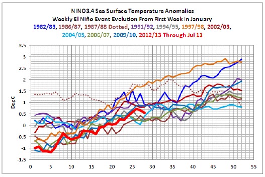
Comparison ofthe evolutions of El Niño events
Bob Tisdale’slatest postcompared the current El Niño’s evolution with others historically. The following are his findings:
1.NINO3.4 sea surface temperature anomalies (a commonly used ENSO index) have been above the +0.5 deg C threshold of an El Niño for 4 weeks. While it’s far from an “official” El Niño, it appears that it’s likely to become one.
The first thing that stands out in the graph is how there really is nothing typical about the evolution of El Niño events. Five started from ENSO-neutral conditions; that is, with NINO3.4 sea surface temperature anomalies between -0.5 and +0.5 deg C.
Five, including the current one, started from La Niña conditions, with the NINO3.4 sea surface temperatures cooler than -0.5 deg C. And there’s the outlier, the 1987/88 portion of the 2-year 1986/87/88 El Niño.
Other than having the coolest NINO3.4 sea surface temperature anomalies at one point, there’s nothing remarkable about the evolution of the NINO3.4 sea surface temperature anomalies this year.
2.The graph below compares the evolution of the El Niño events that started from La Niña conditions. This year’s NINO3.4 sea surface temperature anomalies had been tracking along at the pace of the most recent El Niño, the one that occurred in 2009/10, until recently. Over the past two weeks, NINO3.4 sea surface temperature anomalies have been cooling.
3.NINO3.4 sea surface temperature anomalies appear as though they’re being suppressed by the cooler-than-normal waters being circulated southward from the North Pacific, which should be feedback from the back-to-back La Niña events.
It will be interesting to see how long the cooler waters from the North Pacific can suppress the central sea surface temperatures in the east-central equatorial Pacific.
4.The NINO1+2 region is in the eastern tropical Pacific, just south of the equator. The coordinates are 10S-0, 90W-80W. This year the NINO1+2 sea surface temperature anomalies warmed before the NINO3.4 region, but they also have been cooling.
5.There’s still a pocket of elevated anomalies at depth in the eastern equatorial Pacific, and there’s a long way to go before the peak of the ENSO season.
El Niño Modokai
Till recently, it was thought that the El Niño had only one mode - a periodic warming in the eastern tropical Pacific that occurs along the coast of South America. In 2004, it was discovered to have also a second mode that occurs around 12% of the time.
A Japanese team led by T. Yamagata (that included a prominent Indian climatologist, Dr Venkata Ratnam) noticed the 2004 El Niño was warming more strongly in the Central Pacific region and accordingly stumbled on the discovery of its second mode by sheer accident. They called such an El Nino as Modokai, which is a classical Japanese word which means“similar but different”. The phenomenon is also known as a Pseudo or Central Pacific (CP) El Niño. It was then adopted by K Ashok and colleagues in a 2007 Journal of Geophysical Research paper to refer to central-Pacific–weighted El Niños more generally. Its basic signature is as follows:
1. Weakening of equatorial easterlies related to weakened zonal sea
2. Surface temperature gradient lead to more flattening of the thermocline.
The US, CPC-International Research Institute in a press notesaid average sea sub-surface temperatures persisted in thefareastern Pacific and had recently spread westwards. This has taken place in the eastern half of the equatorial Pacific but recent values of upper ocean heat anomalies continue to reflect ENSO neutral conditions. Equatorial sea surface temperatures (SST) are greater than 0.5°C above average across the eastern Pacific Ocean though the atmospheric circulation over the tropical Pacific reflects cool-to-neutral ENSO conditions.
So there we have sort of a confirmation that the Niño is moving westwards instead of the typical eastward direction.
Further - just when it looked as if a traditional El Niño was getting its sea legs, the event is now looking a bit less canonical. Just take a look at last week’s US-CFS v2 forecasts for Niño regions 1+2 from where it could be observed that the warmest anomalies have been centred in the eastern portion of the ENSO monitoring area.
However, as also seen in the forecast, there is now more of a potential for the temperatures to be much lower. One explanation is that the Niño maybe dying off!! The only other explanation is that the heat is merely transferring westwards - a fact validated through the latest SST departures. The western bias to this summer’s warming pattern is what brings to suspect an El Niño Modoki development rather than a typical El Niño.
The question is that if the heat transfer is taking place westward instead of eastward as typically, are we seeing an El Niño Modoki developing instead of a normal El Niño as commonly assumed? This is not easy to answer as Niño regions 1+2 also appears now to be cooling off along with NINO3.4 SSTs. However such cooling could be temporary and not unusual.
So what’s an El Niño Modokai?
But before we can understand El Niño Modokai variant we need to have to understand El Niño itself. It is part of the El Niño-Southern Oscillation (ENSO) that alternately gives us warm El Niños and cool La Niñas.
An ENSO is a physical oscillation of ocean waters from side to side of the tropical Pacific Ocean. It is kept going by trade winds that push the water westwards along the north and south equatorial currents. Between these two currents is the equatorial counter current and the water piled up in the western Pacific eventually comes back east via that counter current. It does so periodically as a massive wave, observable as a Kelvin wave, because the oscillation is caused by wave resonance and the resonance period is determined by the dimensions of the ocean basin.
As and when an El Niño wave reaches South America at the equator it splashes ashore and spreads out. This creates a large area of warm water, the air above gets warm, an updraft forms that interferes with trade winds, and global temperature rises by half a degree Celsius. But any wave that runs ashore must also pull back. As the El Niño wave retreats water level behind it drops half a meter or more, cold water from below wells up to fill the space, and a La Niña gets started.
But in the case of Modokai, only 20% of the time a La Niña emerges. More often, the Niño dips below the La Niña threshold, but do not remain there long enough to be considered an official La Niña. So if an El Niño Modokai is indeed confirmed this year, it is most likely next year we should be having an ENSO neutral year, rather than a La Niña year. This means, if the El Niño factor is considered as the prime one, we can expect 2013 monsoon season to be within the normal-above average range.
Modokai is but a chaotic variation of a typical El Niño pattern, absent the current gyres that usually form at the eastern terminus. This unique warming in the central equatorial Pacific associated with a horse-shoe pattern is flanked by a colder sea surface temperature anomaly (SSTA) on both sides along the equator. This year, as seen in the above graph, there is a lot of cold water circulating from Alaska down the west coast of Canada, the US and Mexico. This cold water is mixing with equatorial Pacific waters and keeping SSTs in equatorial Pacific down.
The real difference between the normal El Niño and El Niño Modokai isn’t their locale within the Pacific, it is the mode of energy release and it’s spreading out. The former is predominantly a localised event at the sea surface, because a huge spike in humidity which traps emerging energy and spreads it globally via the resulting winds.
Whereas El Niño Modokai is more a global emission of energy from the ocean, resulting in a general humidity increase worldwide rather than a localised blanket of water vapour around a localised emission event, followed by rapid heat loss to space once the warm air is spread out. That is why lower tropospheric temperatures can be expected to remain high as long as 4-6 months after the Pacific event petered out.
So from this month to maybe first quarter next year, global temperatures maybe expected to spike moderately and maybe the last hurrah for global warmists. Once the event is over, global lower tropospheric temperatures can be expected to fall very fast, particularly once the NH winter kicks in. Due to the loss of humidity over the cold land masses; the 2014 northern hemisphere winter could be expected to be extremely cold.
El Nino Modokai’s Effect on Weather
In a paper by Venkata Ratnam et al entitled “Pacific Ocean Origin for the 2009 Indian Summer Monsoon Failure”; effect the following were postulated as effects of El Niño Modokai on weather:
During the boreal (northern hemisphere) summer season rainfall anomalies during the June-September season of the seven positive El Niño Modoki years 1986, 1990, 1991, 1992, 1994, 2002, and 2004. Statistically significant surplus rainfall anomalies are seen in the central equatorial Pacific region flanked on both sides by the negative rainfall anomalies in the equatorial western and eastern Pacific.
The atmospheric condition associated with the western pole located in the equatorial western Pacific is strongly suspected of influencing rainfall from Indonesia, Malaysia, Singapore etc, with the teleconnection extending northwest up to south India and also Sri Lanka.
The teleconnection associated with the positive rainfall anomaly in the central pole (equatorial central Pacific) seems to extend westward via the Philippines, Myanmar to northern eastern India.
In the East Asian region, southern Japan suffers droughts during these years owing to the Pacific-Japan pattern [cf. Nitta, 1987]. The deficit rainfall in the western Pacific region is seen to extend southward to southeastern Australia, influencing a significant part of eastern Australia. The negative rainfall anomalies over the equatorial eastern Pacific extend over western coast of North America.
The result in the Pacific Ocean is less wind shear and therefore more hurricanes/cyclones - the warmer water is also a necessary factor. The result in the Atlantic Ocean is more wind shear and fewer hurricanes/cyclones.
El Niño Modokai Index (EMI)
The Japan Agency for Marine-Earth Science & Technology (Jamstec) developed an El Niño Modokai Index (EMI) as above. The index currently shows that the EMI is still weakly negative but expected to turn weakly positive by this month end or during August.
An El Nino Modoki event is called ‘typical’ when its amplitude of the index is equal to or greater than 0.7α, where α is the seasonal standard deviation. This means even if what is developing is indeed an El Nino Modoki though presently mistakenly assumed an El Niño , this could be confirmed at the earliest only by end of September or October though we could possibly have the first preliminary indication by August end.
Past Impact of El Niño Modokai (summer) on Indian Monsoon
Seasonal rainfall wise, there seem to be alot of variation within El Niño Modokai years ranging 769.9 (87%) to 1,001 mm (113%) of rainfall of Long Period Average (LPA). The average however is 845 mm or 95% of LPA.
Instead of around 175 mm average rainfall for June, this year the country received 115.5 mm or a 29% deficiency. If this year is indeed an El Niño Modokai year, then this should be a new record low relegating 1986 to second place.
With June rainfall poor, does it mean rainfall would get progressively worse? Let’s look at 1992, presently occupying the bottom rung with a 27% rainfall deficiency in June. At the end of the season it still managed to reduce the deficiency to 6% overall. So it is possible that July-September rains to be normal even if June rains fail.
However, this is a simplistic analysis. The performance of the monsoon will depend on other variables such the behaviour of the Indian Ocean Dipole (IOD); Madden Julian Oscillation (MJO), summer temperatures, snow cover, Mascaerne Highs, etc. Nevertheless let’s use the same technique to understand what possible impact El Niño Modoki could have in relation spatial distribution of rainfall as demonstrated historically.
We find that North India, both east and west, relatively tend to suffer a higher rainfall deficiency as compared to the Southern Peninsular with Central India coming out practically unscathed.
Conclusion
What we can conclude with high confidence is that with the El Niño crossing threshold values two weeks later than normal, this is likely to be a positive development in relation to rainfall for rest of the monsoon season.
Should the El Niño be of the Modokai variant, then its adverse impact on rainfall is most likely to be relatively weaker than those of a normal El Niño.
It is too early to confirm the development of an El Niño Modikai this season. We should have better idea by mid August but an official confirmation would be possible only after the monsoon season ends.


.png)
.png)
.png)
.png)
.png)
.png)