Sunday, June 30, 2013

check pages

June 2013 and Overall SWMonsoon over the years... superb comparitive Stats by GSB..on Stats and Analysis Page

Pradeep's Page Updated with June SWM Toppers

Mumbai Page has details of Mumbai Region June Rains and State capitals Pictorial Designed by Rohit Aroskar

June Results of Monsoon Contest Declared..See June Result Page...July Entries Open


Posted Sunday Night 11.55 pm IST

1. As on Sunday evening, Monsoon Axis slips into the Himalayan Foothills, with Low embedded in UP region. Axis runs from Himalayan Foothills thru Low pressure and thru Gaya into another low over Gangetic W.Bengal.

2. Axis will persist in the North for  a couple of days, and will support an Upper air trough over Northern MP by Tuesday. This Upper air trough will have an UAC embedded at 700 hp, also over the North MP region.Axis may slide a little Southwards in the North MP, Southern UP region. Precipitation in the Jaipur-Gwalior-Lucknow line.

3. Due to this developments, and weakening MJO over our seas, West coast trough will remain, and fluctuate mildly next week.

4. From 3rd July, 200 mb jet streams, hitherto unfavourable , being westerlies and forming a high over Northern regions, start becoming favourable for NW India and Sindh from 3rd July. SWM remains stagnant over the regions shown in vagaries' map, refusing to move further.

Another regional report on Monday.

Friday, June 28, 2013

Western USA staggers under massive heat wave; 1 dead

Temperatures in Las Vegas shot up to 115 degrees on Saturday afternoon, just two degrees shy of an all-time record, as the Desert Southwest continued to stagger under a relentless heat wave.

In Southern California, Palm Springs peaked at 122 while the mercury in Lancaster set a record at 111, according to the L.A. Times.
The forecast for Death Valley in California called for 128, but it was a few degrees shy of that, according to unofficial reports from the National Weather Service. Death Valley's record high of 134, set a century ago, stands as the highest temperature ever recorded on Earth.
Phoenix hit 119 by mid-afternoon, breaking the record for June 29 that was set in 1994.
Pics from Vagaries' Meet on 30th June 2013 on Inter active Page

Posted on 28th June, Friday Evening:

The 2 day Saturday Sunday forecast is put up in map form:City forecast below.


Mumbai: Saturday will be cloudy with some showers in different parts of City. Gusty winds  from SW at 30 kmph, with more showers by evening/night,. Rain Amounts will be 25-30 mms average.
Sunday will be more cloudy with rain frequency increasing. Heavy showers expected by late afternoon or evening. Rain Amount for city and suburbs 30-35 mms avg.

Delhi NCR: Saturday/Sunday:Partly cloudy with thundery developments in vicinity. Some drifting in Eastern parts possible. Day will be around 37c.
Heavy showers expected on Monday night into Early Tuesday.Rain Amount will be given later as the conditions develop, but could be in excess of 45 mms.

Chennai: Warm and stuffy, with chance of showers in some areas on Sunday night.

Kolkata: Good chances of Thunder Showers on Saurday evening/Night, with precipitation amounting to 25 mms. Sunday will see a decrease with rain in some areas.

Lucknow will get heavy rains this weekend. Rainfall may be > 100 mms on Saturday/Sunday. Kanpur will too be lashed by Heavy rains.

Bhutan can recieve very heavy rainfall on Saturday.

Similarly, Heavy rains are expected along the lower plains of Nepal on Saturday and Sunday. Kathmandu can get thunder showers on both the days, amounting to 20-25 mms.

Saturday/Sunday: Northern Pakistan, North of Punjab will get some rain showers. Nawabshah, Sukkur will be around 42c, Sindh and Central regions will be dry and hot. We see temperatures touching 48c in Nokkundi.Sindh will need to wait for a few days more for meaningful rains, as even the rains in the North decrease early next week.

x-----------------------------x----------------------------------x----------------------------------x
June 27th ..SWM June Position for India...5th Best in 113 years

This Year , as on 27th June,  (IMD takes last Wednesday as the June %), All India SWM surplus by +38%. 
On record, we have only  4 years ( prior to 2013) with SWM surplus over 38%  (June End)  in the last 113 years  ! 

1913; +38%,  1917: +37.8%,  1936: +48.9%,  1938: +56.6%, 1971:+43.1%,  1980: +37.7%,  2013 :+38%

(Just for Information:On all the above years, July of the above years have been deficit !)


The SWM performance Map of 2013, as on 27th June, shows most regions in surplus or excess. Rarely do we see such a superb performance map ! Uttrakhand Surplus by +231% !
But it should be remembered that the premature arrival of the Monsoon in a major part of NW and Northern India added to the surplus rains.
Charts will be put up showing the actual June end position by 3rd July.

Due to non availability of reservation, Vagaries' Sunday meeting will be held in South Mumbai. Meeting scheduled for Atria Mall, Worli on Sunday 30th ,at 5 pm ...Thanks and please make it convenient to attend.

Wednesday, June 26, 2013

Fastest to 2000 mm in last 5 years..?? See Answer on Pradeep's Page
Mumbai -Pune -Nashik triangle...from Rohit Aroskar...See Stats and Analysis Page


Vagaries' Monsoon Meeting has been arranged for Sunday 30th June at a venue to be decided in Thane...Meeting and Inter Action will be at 4 pm...All are requested to please make it convenient and attend...Await Venue Details...

Posted on Wednesday @ 00.30 am IST

1.      -BB-4 Situated on Tuesday Night in the Northern Chattisgarh and adjoining East Mp region. An UAC lies to the SW of this system, where maximum clouds are associated.
2.       -System likely to move N/NW and enter Southern Up. Consequently it will merge with the monsoon axis.
3.       -West Coast off shore trough persists in current strength.
4.      - Heaviest rainfalls  ( 70-120 mms) next 2 days will be concentrated in the Central Up (Lucknow) area, Northern Bihar and Northern West Bengal.
5.      - Moderate  (30-70 mms) heavy rains along west coast of India, Southern regions of Uttarakhand.
6.      - Light to medium rains (10-30 mms) in West UP, Delhi NCR, Interior Maharashtra, Saurashtra , Gujarat Region and Kerala. 

Forecast for 2 days, Wednesday/Thursday:
Mumbai will get occasional showers, some heavy, but not persistent. Rainfall next 2 days will be around 30 mms /day (average).
Outer townships will have heavy passing showers, with bright intervals at times.

Pune: Cool cloudy days, at around 27c. Decrease in rainfall next 2 days. Light rains in some parts and 5-7 mms/day.

Delhi NCR: Rain chances decrease as BB-4 curves More towards North, and merges with the axis and pushes it Northwards by Thursday. However, isolated thundery developments are possible, with precipitation in some parts of NCR. Where it rains, precipitation could amount to around 10 mms. More chances on Wednesday, as clouding and associated UAC will dissolve in the Northern MP region. Northern MP and adjoining Rajasthan (Jaipur) can get the isolated Thunder storm , and the odd one could travel to NCR (Wednesday).

Surat: An increase in rainfall on Wednesday could bring 15-20 mms in form of some sharp showers. Thursday also will get passing showers amounting to 10-15 mms.


Chennai: Chances of thunder and rain in some parts of Chennai on Wednesday. Measurable amount would be about 7- 10 mms

Sunday, June 23, 2013

 Pradeep's  Page Updated with new Information....

Posted on Sunday @  20.00 hrs IST on 23rd June 

BB-4 is positioned off the Orissa coast and at 996 mb pressure. It has an associated Upper Air Trough towards the SW, in the interior Orissa and Chattisgarh/Vidarbha region. 
The system moves Westwards on Monday. 

Sunday Night/Monday, we see heavy rains in Orissa State, with concentrated heavy rain in the Sambhalpur-Rourkela belt.Southwards towards Balangir we see heavy rains. The rain belt stretches along the coast into Coastal W.Bengal. Kolkata gets increased rainfall on Monday.

Tuesday, as BB-4 moves inland, we see precipitation in the Vidharbh and Marathwada regions of Maharashtra. Nagpur,Gondia, Khamgaon and Akola regions get heavy showers.
By Tuesday evening, rainfall moving into adjoining MP, with Ujjain region and the Indore -Itarsi belt getting heavy rains.
Rains move into Eastern Gujarat also.

Wednesday, precipitation seen in Eastern Gujarat region.But the eastern quadrant of the system brings rainfall to the Western MP region, especially the Itarsi-Indore belt. Adjoining Kota in Rajasthan can possibly  get rains also.

Along the west coast we see an increase in precipitation Northwards of Goa from Monday night.

Mumbai could see some increase in rain intensity from Monday night and thru Tuesday, the frequency of rain showers will increase.But moderate, as stations along Coastal Karnataka and Konkan average between 20-40 mms/day for next 3 days.

Likewise, Pune will see more cloudy overcast conditions from Monday or Tuesday with increase in rain frequency on Tuesday.

Light rains/Thunder showers creeping into the Delhi NCR  on Tuesday with around 10 mms expected. But Wednesday (an Upper Air trough takes position) could see a heavy thunder shower in some parts, with up to 25-30 mms. May break again, depending on the axis.

The Monsoon axis could possibily shift North from Thursday...But we will wait and watch the BB-4 final movements. 

Uttarakhand will get showers on Monday and more heavy showers after 27th June. We presume the axis shifts Northwards.
Nepal can get excessive rains if this happens.

Hot and dry for Sindh and Southern Pakistan. Hottest spots reaching 47c...Sukkur may touch 45c and Karachi hot and dry at 35 (Heat Index 40c !)

x--------------------------x------------------------------x-----------------------------x------------
As a token of appreciation and acknowledgemnet of Pradeep's consistent devotion and hard work, Vagaries has devoted a seperate Page on its main blog exclusively for Pradeep. This is for the first time in its 5 year history that Vagaries has alloted a separate page for an individual.

Vagaries' readers are assured of Pradeep's contribution and expertise enhancing  the fair name of the Blog Internationally.

Wednesday, June 19, 2013

A day ahead of vagaries' forecasted date, BB-4 Forms on Saturday  off the Orissa coast...initially at 998 mb..

For Nagpur Readers..Lokmat Times Nagpur Shares my views here.."Monsoon Takes a Break..."

City wise outlook for  Friday 21st/Saturday 22nd/Sunday 23rd June :

Mumbai: Friday;
Sunny Spells. A few sharp showers post noon. Average rain amount: 20 mms.
Saturday: Cloudy with some bright periods. Several parts will see occasional sharp showers of 10/15 minutes durations in the day amounting to around 25 mms.
Sunday: Partly cloudy interrupted by brief sharp shower or two. Rain amount around 20 mms.

Some of the Outer townships
will have rain amounting to 45-55 mms /day Saturday and Sunday.Sunday may be accompanied by thunder.

Pune: Friday/Saturday/Sunday:
Partly cloudy. A shower or two in some parts. Amounts will be 5-10 mms/day.Day temperature around 29/30c.

Surat: Frequent showers on Saturday amounting to 25-30 mms. Decrease on Sunday. But showes will be occuring and rain amount will be 15-20 mms.Pleasant day around 30/31c.

Nagpur: after a hot Saturday, the evening can see a heavy thundershower, amounting to 30-35 mms. Increased rainfall on Sunday, with very cloudy sky.
Heavy thunderstorms on Sunday will dump around 50 mms of rain by evening
Monday willl see good rainfall.


Delhi NCR: Friday/Saturday/Sunday will see scattred clouds and hot day. With west winds blowing, the day's hugh will be 38/39c. Maybe touching 40c in some regions.Thundery development possible on Sunday evening.

Karachi: Friday/Saturday/Sunday: Cloudy and windy . Though day's will be around 34c, heat index high at 38/40c. Light rain possible on Saturday night /Sunday.

Sukkur will be dry and hot. Day temperatures rising to 45c !
 

Kathmandu: Heavy Thunderstorm likely on Friday night. Saturday overnight rains may add up to 35-40 mms. Saturday and Sunday, otherwise, Normal evening thundershowers possible on the odd day . Between 5-10 mms precipitation.

x----------------------x--------------------------------x----------------------------------x------------------------x
All India Actual SWM Performance from 1st June -19th June 2013: 130.7 mm, Normal: 84.7 mm and Departure: +54% (last year to date -26%).. June Month normal total rain 173 mms.
State Capitals of IndiaRain till June 20th 2013..Another Graphics by Rohit Aroskar..see Stats ad Analysis Page

The Sub_Continent Expectations from Thursday 20th June till Sunday 23rd June:

1. An UAC forming around the Andaman Islands in the Bay will travel NW. Will, mostly, descend to sea level on Sunday 23rd, and BB-4 will be off the Orissa coast.
Another UAC forms off the TN coast, but merges in the trough (formed by the UAC) in the Bay.
Thursday Report: UAC forms over Bay located NW of Andaman Islands.

2.The west coast trough will persist as a weak trough.The Northern end of the trough is supported by an Upper Air trough in the Sea. Some spill over showers in Saurashtra. 
Possibly, a vortex may form for a couple of days off the Karnataka coast on the weekend.Heavy rains ( 40-100 mms) in Coastal Karnataka (weekend). Variable (10-40 mms) rainfall along rest of west coastline. Average/Below average rainfall in interior Mah.and Karnataka.

3. A weak low forms in the Arabian Sea off the Oman Coast on Thursday 19th. It imminently moves inland. Some light rains in Eastern Oman.
Thursday Report: Weak low moving inland into Southern Oman
The resultant SW winds into SE Sindh may bring light rains to SE Sindh region and corresponding coast. 

4.The Monsoon axis runs along the Himalayan foothills. Almost merging into Nepal on Friday.Heavy rains in Nepal. 
The extended eastern arm remains weak. Maybe just extending to Meghalaya by Saturday.Heavy rains in Northern Bangladesh and Meghalaya.
Almost dry and no meaningful rains in NW India and most of Pakistan. SWM remains stationary.

City specific forecasts if required.

SWM monsoon rainfall .. Till 19th June 2013..
Konkan , Ghats and some parts of Madhya Maharahtra. Pictorial composition by Rohit Aroskar....see Stat and Analysis Page 


Venus’ Winds Are Mysteriously Speeding Up to....
400 km/h (250 mph) in 2012. That’s nearly double the wind speeds found in a category 4 hurricane here on Earth!...See Space News Page

Lake Levels of water supply to Mumbai and General Maharashtra Position..See Mumbai Page

Tuesday, June 18, 2013


City Forecast for Wednesday, 19th June:

Mumbai can expect cloudy skies, with sunny and bright intervals as the day progresses.
showers at times, with a few heavy.Showers amounting to around average 30 mms will be distributed during the day. Hence not very persisting showers.

Pune: Cloudy skies, with brisk Westerlies blowing. Light rains in some parts, with the odd medium shower possible. Rain amount 7-10 mms.

Surat, cloudy, but brightening bu late afternoon. A couple of showers possible, an amount less than 10 mms possible.

Kolkata: a couple of showers in the day. The odd one can be heavy in some parts. Rain amount would be around 15 mms though.

Delhi NCR: Though it will be almost calm, Sparse clouding could prevent the sun from shooting the day over 36c. No system to  precipitate any rain over NCR.


x----------------------------x------------------------------x--------------------------------x
Immiedietly on Setting, SWM throws its weight in many States of India. Severe flooding of main rivers in Uttarakhand has left many dead and marooned
Some Prominent Rainfall Amounts in cms in 24 hrs ended Tuesday Morning (17th June):

In Uttarakhand: Dehra Dun 37, Mukteshwar 24, Hardwar 22, Uttar Kashi (CWC) 21, Kosani 21, Haldwani 20, Nainital 18, Tharali 17, Tehri 17, Tehri (CWC) 17, Deoprayag 16, Bageshwar 16, Mussoorie 15, Roorkee 15

In UP: Saharanpur 20, Harpur 16, Narora 16, Nakur 15
In HP:Paonta Sahib 41, Kalpa 19, Renuka 15, Sangrah 11

In Haryana, Delhi and C'Garh:Chhachhrauli 27, Chhachrauli (ARG) 27, Bilaspur 27, Jagadhari 26, Delhi (Palam) 12

In MP: Gohad gets 23 cms.

In Gujarat: Khambhalia 21, Babra 18, Rajula 15, Lathi 14, Hansot (ARG) 18, Hansot 14, Pardi (ARG) 14, Balasinor 12, Halol 12, Mahesana 12

In Konkan :Matheran 27, Uran 26, Panvel 26, Karjat 23, Mumbai (Colaba) 21, Khalapur 20, Pen 19, Ambernath 19, Khed 17, Murbad 17, Ulhasnagar 16, Mumbai (Santacruz) 15
Mahableshwar 29 cms


In Kerala :Irikkur 18, Kannur 18, Piravom 14, Vadakara 12


All Model Calculations go for a toss..a fresh Voretx form unexpectedly, overnight, off the N.Konkan coast. Subsequent strengthening of the trough off the West Coast of India..
Embedded Vortex seen strongest till 700 hp level ..
Mumbai sees rain force gaining again..can raise estimate to 100-125 mms next 24 hrs


Sunday, June 16, 2013

 SWM moves in to Kutch...95 mms rain in Anjar, 75 mms in Mundra, 52 mms in Gandhdham (Kutch) and 38 mms in Rapar and 32 mms in Nakhatrana...good enough begining for Kutch..Posted on Monday 17th Evening

Rainfall Figures in mms for Raigadh and Thane District as on Monday Morning 17 th june...see Mumbai Page for complete List

1. BB-3 has fizzled out on sea level, but maintains strength as an UAC.
2. The UAC in the Arabian Sea, at the head of the off shore trough, will stabilise more prominently in the South Gujarat region, and get the trough in a "vertical" position.
The UAC will move NE and cross Gujarat coast near Veraval on Sunday night.

Resultantly: On Monday 17th: Heavy rains in South Gujarat (Surat >100mms and Bharuch), South coastal Saurashtra (Veraval and East of it),  In Guj: Ahmadabad, Baroda, Surat, Bharuch, Gandhinagar, Bhavnagar and Palanpur).
Monday very heavy rains in Uttarakhand and adjoining UP and some sharp showers in adjoining NCR.

Tuesday 18th: Heavy rains in region where Guj/Raj/MP borders meet. In MP:Indore, Ujjain, Ratlam, Barwani and In Rajasthan:Kota, Udaipur and Banswara.

Wednesday 19th: Rains move towards Delhi NCR as UAC gets weaker. The trough runs from Delhi SW towards Gujarat. 

Next 3 days: West coast gets good rainfall as trough remains intact.
Rainfall for a day more in Nagpur. Monday may see showers and about 5-10 mms of rain. But sharp decrease from Tuesday, and day temperature climbing to 34/35c in East Vidharbha again.Showers continue in Western Vidharbh.

South Eastern Peninsula remains almost dry. Chennai cloudy but just a stray shower possible.

Mumbai: Rainfall decreasing from Monday. Monday will be cloudy and 3/4 showers, some heavy. Tuesday and Wednesday will see sunny intervals. Occasional showers next 3 days. Some showers will be heavy but not prolonged. Rain amount for Monday 35 mms, Tuesday and Wednesday 25-30 mms (average).
Outer townships will see some sharp longer duration showers on Monday, but decrease in rains from Tuesday. Rainfall amounts 40-50 mms on Monday slight decrease next 2 days.
Pune: On Monday, Showers up to 10 mms in some parts. Decreasing from Tuesday .

Delhi NCR: Monday: Some showers. Eastern parts can get sharp showers adjoining UP State.Average rain amount 10-15 mms.
Decrease for a day on Tuesday, with sunny intervals, and slight increase on Wednesday in rain frequency.Average rain amount for Wednesday 10/12 mms.

Surat: Heavy rains from Monday night thru Tuesday. Excessive amounts. Rains tapering off from Tuesday.

Isolated Thunder Showers on Monday, Tuesday and Wednesday in Central Sindh. Nawabshah and Sukkar have a hit and miss chance, or evening showers in the vicinity.
Islamabad also gets warmer next few days as rains move away..maybe touching 40c soon.

SWM has moved in to Nepal. Heavy showers in West Nepal on Monday. Kathmandu has recieved 130 mms in June, so around half the June total. The normal June total 236 mms will be achieved. Next 3 days will be cloudy with some evening showers. Days will be around 27c and nights 19/20c.

SWM Covers all parts of India eaxcept West Rajasthan and Part of Kutch. OLR and other humidity parameters (as per IMD) do not confirm total advance in these regions...see Monsoon Advance Page.

UAC off Saurashtra coast moving NE. Heavy rains for South Gujarat (Surat and Bharuch), ujarat region (Ahmadabad and Baroda) and south coastal Saurashtra on Monday. Rains decrease in Mumbai ..BB-3 becomes UAC and is pushed NE towards Delhi....details being written for blog now,,and will be published in an hour...SWM advances into all parts except Rajasthan and Kutch..

Thursday, June 13, 2013

Much Awaited Monsoon Analysis to Date  from ..None Other than Our GSB..on "Stats and Analysis" Page..Just Recieved

On Saturday Evening, Vortex Forms Off the West Coast of India near North/Central Konkan...See Current Weather Page here
Heavy rains lashing Central and Southern Mumbai since last nigh, with thunder /Lightening.
Scruz measured 57 mms in 21 hrs till 05.30 am IST.  ...48 mms till Saturday mid night  and 9 mms  after mid night till 05.30 am into Sunday, Vagaries measured 75 mms till Saturday mid night and 32 mms after mid night till 07.30 am Sunday,

BB-3 Current Position (In Yellow)  as on Saturday evening Redrawn on the 14th June Track Chart (Moved along "designated   Path as original  in the Thursday blog below)..


Brief Saturday, 15th June Report as on 5.30 pm for Mah:..Mumbai Page
Lakes Levels supplying Water to Mumbai City as on 14th June..See Mumbai Page

Posted on Thursday Night @ 11.00 pm IST

The axis of the Monsoon runs from SE Sindh thru Southern Rajasthan MP through Centre of BB-3 and into the Bay.The western end of the axis is "supported" by the low which normally appears in the Southern Sindh region of Pakistan (to support" the axis),some time around Mid July.
This would normally be the natural position of the axis in mid-July. 
The continuing SW winds into the UAC over Punjab have "introduced" rains in the newly formed Low over the SE Sindh region. Tyronne reports of good showers in Karachi.

Now, with BB-3 as a well marked Low, we will see this system tracking along the axis route in the next 3 days.


Saturday, very heavy rains in Vidharbha and adjoining Northern AP.Heavy rains in Western Vidharbha  Hyderabad in AP can receive heavy showers too.

Sunday and Saurashtra and Eastern Gujarat may see very heavy rains.Places may see > 125-150 mms.
Almost negligible rain in South-Eastern Peninsula


Mumbai: Friday will be cloudy with heavy showers interspersed with gaps in rainfall.Rainfall increasing on Friday night.
By Saturday morning, Mumbai may get around 60 mms.
Saturday will be overcast with intermittent showers and heavy spells. 
Increasing rains again leading to a wet Sunday.Saturday will get around 60 mms.
Sunday may well see 80-90 mms of rains.
Pune: Friday and Saturday partly cloudy with light showers in some parts. Sunday cloudy and increase in rains, maybe upto 25-30 mms on Sunday.

Surat will see an increase in rainfall from Saturday Night.Sunday i see a possibility of >100 mms.

Next 3 days for Delhi NCR will see a Thunder Shower in some parts or vicinity. Rainfall chances are more on Saturday and Sunday, with around 25 mms possible.
.
Karachi which has seen some rain from the Low, will see a decrease in rainfall from Friday itself. Generally cloudy and some rain in vicinity on Friday. 

Tuesday, June 11, 2013

 vagaries had put up the expected course of BB-3 (it had not formed then) in the current standing article on blog. With BB-3 now formed, we shall observe the course parametres like 200 hp winds, 700 trough and sea level "corridor" and estimate its path. Would not jump to conclusions now, and then change..but, will put up on vagaries tonite..

Synoptic Situation as on Tuesday Night (11th June)

1. The 200 hpa jet streams have become westerlies in the absolute North of  the sub continent.This indicates an easier movement of systems from the Bay to move inland without any sort of "resistance."

2. The UAC in Northern most regions of India and Pakistan are attracting SE winds interaction with SW winds. Along with the heated lands, it has brought about massive clouds and thunderstorms. Rawalpindi had a severe dust storm with rain on Tuesday evening.

3.The trough at the 700 hpa level will strengthen in the NWI and Northern India regions in the next few days. Due to resistance from 850 hpa level in Central India (the UAC), the upper air trough (700 hpa) will precipitate thunder showers  some severe, along the plains of UP, Haryana and the foothills of Himalayas till Saturday 15th June.  (SWM advance could be announced)

4.Today's newly formed UAC in the Bay will now, in all probability track W/NW and move along the Central Indian regions.From Thursday 13th June, precipitation will move westwards thru Orissa and Chattisgarh.

By Sunday 16th June, we may see precipitation in Gujarat and west coast of India (details later as we approach the dates), and move into Coastal Sindh and Karachi early next week.
Southern and interior peninsula may see a relatively "less rainfall" period till Monday 17th.

We will monitor this daily, and On Thursday, vagaries will put up another detailed forecast schedule...

Mumbai: Rainfall remaining weak till Saturday. Increase in rains from Saturday.
Delhi NCR: Some showers on Wednesday night/Thursday morning. Rainfall in 24 hrs period around 15 -20 mms.

Chennai generally cloudy.

Kolkata chances of Thundershower in some parts on Thursday.Major rainfall still evasive in Bengal.


Much Awaited SWM Toppers list as on 10th June. On Stats and Analysis Page....from Pradeep (of-course)

Monday, June 10, 2013


10th June: SWM Moves into Ahmadabad, more parts of Saurashtra and Kolkata...see Monsoon Advance Map

In a fresh development, an UAC can form in the Bay off the North Andhra/South Orissa coast by the 12th of June.
The system, may form a low, or travel W/NW as an UAC. Along the track, we can expect heavy precipitation into Orissa and later into Chattisgarh, East Vid, MP and Southern UP. Delhi and North Rajasthan from 13th through 17th June.

West coast can expect "sympathy" rains if the UAC is strong enough.
We shall monitor the progress as the UAC forms. 

Mumbai on Monday night will get frequent showers, some heavy. Tuesday will see several showers, some of prolonged duration and heavy.

The Elongated Vortex off the Northern region of the West Coast of India. This vortex, at 700 hpa, has now elongated till South Gujarat Coast. Map of 8.30 am Monday...Predicted an afternoon let up in Mumbai Rains as vortex not very deep ..


Sunday, June 09, 2013

June 10th Last Day for Vagaries' June Contest....See June Contest Page for Details

Outlook for Monday, 10th June..
Mumbai: Cloudy skies, with intermittent showers.Few heavy showers in some parts of City. Rain Amount (average): 45-55 mms.
Rainfall decreasing on Tuesday.

Pune: Cloudy and cool day. Some showers in parts of city. Rain Amount 7-10 mms.

Delhi NCR: Hot day, maximum around 42c. Thundery developments may be far South of NCR in Rajasthan. Some Dust Storms may drift towards the Southern Parts.
Inter action of Easterlies from the Bay and SW winds from the Arabian Sea, could result in pre Monsoon Showers in Delhi NCR from 14th June.

Chennai: Warm humid and partly cloudy. Maximum at 37c. Thunder clouds may drift in some parts of city by evening.


Friday, June 07, 2013

Posted @  4.00 pm IST Sunday:  SWM advances into North Konkan and .Marathwada up to 20N ..Upper trough runs horizontal along 20N line.....stagnant in Eastern Branch as per Vagaries Map

Posted @ 22.45 IST Saturday: 

Same position as the morning 5.30 am IST ….. The off shore vortex is stagnant around the S.Konkan region as per the 1200 hrs Charts..

The upper air trough is persistently remaining in the “horizontal” position, and extends from the mid Arabian Sea UAC  towards the vortex. Clouding seen is around the mid sea UAC and along the S.Konkan coast.

It seems from the current conditions, that the UAC will dissolve, and the vortex will strengthen. It will possibly move a bit Northwards towards Central Konkan region  by Sunday.

In this circumstances, I could hold on to my Sunday forecast for Mumbai. Expecting around 65-85 mms in Mumbai (average) on Sunday. . By Sunday, with the vortex, the SWM could move Northwards towards Mumbai.
Peak vortex location could get in excess of 150 mms on Sunday (Central and S.Konkan).

On Sunday, we could see the off shore trough extending from Saurashtra to Kerala. Hence rains along the Gujarat coast and Saurashtra would be prominent on Sunday Night/Monday


As the vortex persists in the S.Konkan region, and the OLR not yet going below the 200 count, I would maintain the SWM at the same position as shown in the vagaries map (at S.Konkan).

Tentative Estimate of the SWM progress into Northern India and then into Pakistan…

A trough in the 500-700 hpa region  can form from the heat low over NW India. It could possibly form around the 14th/15th of June. This will be of extra benefit, as it will attract and pull moisture from the Arabian Sea into the NWI regions thru Gujarat.
As this will be a low covering a fairly large area, from 14th/15th June, we could see the moisture flowing into Southern and Central Pakistan region also.

The low in the upper regions will also attract the Easterly winds into Northern and NE India, from the Bay of Bengal.

Later, maybe after the 15th  June, as a result of the inter action of the Easterlies and SW winds from the Arabian Sea, we could see the SWM progressing into UP and then into Delhi NCR.

More on this later, as I do not take credit of Long Term Forecasting…

x-----------------------------x-----------------------------------------------x----------------------------------x

Posted @ 1.30 pm IST Saturday: Anticipated Vortex at 700 hpa forms over South Konkan !! Mapped and Charted at 8.30 am IST Saturday..


Vagaries expects the vortex to get embedded in the off shore trough..more as it happens !

Fantastic Maharashtra rainfall amounts posted in comments by abhijit.

Posted @11.30 pm Friday: A trough is getting stabilised at the 700 hpa level off the west coast of India. As anticipated earlier, the likelihood of an embedded vortex in the trough remains a possibility. Studying the wind shear and other factors, it seems the vortex can form as early as Sunday.

The vortex, in all probability, can form anywhere between Dahanu and Goa on the west coast. The region and area of vortex may be small. But, we can expect  >100 mms of rain on Sunday, or when the vortex forms.

Lets keep a watch on this..if it happens...

Thursday, June 06, 2013

7th June 2013: SWM advances into South Konkan and S.Maharashtra and most parts of AP...see Monsoon Advance Page for Updated Map..

Mumbai Expected to get heavy rains on Friday: Heavy Thunder Storm expected on Friday afternoon /evening as Upper air trough at 700 hpa forms and aligns itself as an off shore trough. Since morning, the sea level pressure is low at 1003 mb, and humidity high.
 

Upper air trough expected to "push into the coast" in the N.Konkan region by Sunday.
Sunday Mumbai should see heavy rains. I would put accumulated rainfall from Friday 7th -Friday 14th at around 220 mms...

SWM advancing into S.Konkan  today...


Monsoon Outlook bright for forecasted Advance along  West Coast:
(For detailed learners, see note on yesterday’s blog first, and then proceed with this blog)

With the expected formation of an upper air trough (at 700 hpa), roughly in the 20N line in the Arabian Sea, we see enhanced prospects of the Monsoon “respecting” vagaries’ expected date of arrival along the west coast of India.
This trough is expected to extend Eastwards, and form an off shore west coast trough, tilting westwards by Friday 7th.

On Thursday 6th, we see an embedded UAC near 60E (off the Oman coast). 
Soon, within 2 days, it will align itself from Saurashtra  downwards thru  Konkan  upto  Kerala.

As the SW wind strength and depth will be upto the 700 hpa levels, we can expect the Monsoon to  advance into Goa and South Konkan by Friday 7th. Heavy falls expected in Goa and South Konkan next 2 /3 days.

Seemingly good support from a NW India upper air low, we can safely assume SWM to move into North Konkan and Mumbai by Sunday, 9th. (a day later than vagaries’ forecast map).

Evening Thunder Showers in parts of Mumbai on Thursday, increasing on Friday and Saturday.
 Rain Amount (average) for Friday and Saturday:  10 mms/day. Sunday we can expect a slight  increase in rainfall amounting to 15-20 mms.
Outer townships: Friday  almost all regions can get thunder showers.  can expect heavy thunder showers on Saturday and Sunday. Rain amounts will be more than Mumbai figures.
Thunder Showers in the evening for Pune..though not very clear of SWM advance this week end !
Saurashtra will be getting thunder showers and rains this week end.
Though estimating rains in Saurashtra, Surat may not get the full brunt of rains till middle of next week

SWM Advance Forecast Map Updated  on Wednesday to cover Sub-Continent...See Monsoon Advance Position Page


Tuesday, June 04, 2013

For Participants..The results of the Tutorials posted on 4th June @ 11 pm IST...on Inter Active Page 
SWM Advance Forecast Map Updated to cover Sub-Continent...See Monsoon Advance Position Page

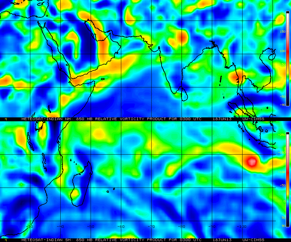
Posted on Wednesday @ 11.30 pm IST
SWM advancing into SE Bangladesh and NE States….SWM precipitation to increase in Coastal Karnataka and Kerala from Friday..

The West coast trough, though weak, runs from Goa to Kerala.
Another trough runs from S.Konkan and North –Westwards  towards Oman coast.

An UAC will be embedded in the mid sea trough. This trough will start tilting towards the N.Konkan coast from Friday. It will be part of the off shore west coast trough by Sunday.
Rainfall along N.Konkan , as a result, will start increasing from Friday onwards.

Forecast for Thursday Heaviest Rains:
Maharashtra: Heavy thunder showers in Pune and Southern vicinity. Nanded  and South Marathwada.
AP: West of Hyderabad, Medak and Nizamambad disricts.
MP: West and East  Dimmar, Ujjain and Indore regions .

: An early afternoon  thunder shower in Bangalore and vicinity.
: Mumbai will be partly cloudy. Thundery developments over the eastern ghats. Drifting of some thunder showers possible in evening over parts of City and outer townships.
City rainfall up to 7-10 mms possible.

x--------------------------x---------------------------x---------------------------x
Posted on Tuesday 4th June @ 4.30 pm IST:


1.       The west  coast  off shore trough runs from Goa southwards.

2.     The UAC in the Arabian Sea has descended as a low, and at 1000 mb is situated at 19.7N and 64.5E.

3.       This low, will  form a trough, running East West at around 20N.

4.     The trough will slant NW/SE and gradually join the existing off shore trough,  become the west coast trough running from Gujarat to Kerala. This phenomena will bring the SWM up the Konkan coast and into Interior Mah and Gujarat.

5.    How many days ? We shall observe this development, but anything  between  4-7 days from June 4th

Meanwhile, Mumbai forecast remains as mentioned yesterday, there will be the thunder shower in parts of the city and vicinity by evening...

Pune and rest forecast too maintained as yesterday.

There will be some sharp showers in Southern Oman and Salalah regions for a day on Wednesday. Chances of rain in the Muscat region are less, only cloudy skies. .It seems at this stage  System will not move directly in to Oman, but weaken and form a trough towards the East.
We shall observe the system.

We are not the Centre of anything..not even our own Galaxy !..See Space News Page

Monday, June 03, 2013

Posted on Monday 3rd June at 11.50 pm IST:

South West Monsoon has  further advanced into Coastal Karnataka and some parts of S.I.Karnataka.
Progress was initiated by a strengthened Line of Wind Discontinuity running thru central Peninsula, and strong W/SW winds from the Arabian Sea.Sufficient isobar gradient also got the SWM Northwards.
Monsoon progress shown on Monsoon Advance  Page…


Forecast for Tuesday 4th/Wednesday 5th/ Thursday 6th June:


City Forecasts for next 3 days, 4th/5th/6th June:
Mumbai will get a few Thunder Storms in some parts of city  and in vicinity.. Rainfall around 5-7 mms/day
Some outer townships can get thunder storms.

Pune will get thunder showers in some parts of the city.

Delhi NCR region rising to 44/45c by Thursday. Night temperature likely to rise to 32/33c.

No meaningfull precipitation for Surat and Nagpur.

Surat may get light rain on Wednesday.

GFS Forecast map for 3rd June - 9th June from Jim (Accuweather) on Inter Active Page..
x------------------------------x----------------------------------------x-----------------------------x-----------------x
Today (Monday)  rain in Maharashtra  till 5.30 pm


...Mahableshwar 37 mms, Satara 28 mms, Ahmadnagar 17 mms, Pune 7 mms,  Pune AP 5 mms, Kolhapur 9 mms, Panjim 0.9 mms and Rgiri 0.6 mms.

Mumbai Colaba 2.6 mms, Scruz 1.0 mms and Vagaries 0.2 mms till 8.30 pm IST

Forecasted East rough  Let's look into the 3rd week of March ( 17th - 21st). Mumbai : Hot weather likely for Mumbai region this week, ty...